ATL: DORIAN - Models
Moderator: S2k Moderators
-
SFLcane

- S2K Supporter

- Posts: 10281
- Age: 48
- Joined: Sat Jun 05, 2010 1:44 pm
- Location: Lake Worth Florida
Re: ATL: DORIAN - Models
06z Euro is even closer to FL coast what 30-40 miles from that graphic? 
0 likes
-
hohnywx
- Category 2

- Posts: 511
- Age: 34
- Joined: Sun Jul 19, 2009 8:34 pm
- Location: Hastings-on-Hudson, NY

Re: ATL: DORIAN - Models
That's a significant shift West compared to 00z. A lot of people have been saying this for a while, but one more of those shifts and we could be looking at a landfall. The 12z runs will be nailbiting.
0 likes
-
gatorcane

- S2K Supporter
- Posts: 23708
- Age: 48
- Joined: Sun Mar 13, 2005 3:54 pm
- Location: Boca Raton, FL
Re: ATL: DORIAN - Models
gatorcane wrote:USTropics wrote:00z UKMET ensembles:
Yes they shifted east some but many through Florida

Bumping to new page. Do they run these at 06Z?
1 likes


Re: ATL: DORIAN - Models
gatorcane wrote:gatorcane wrote:USTropics wrote:00z UKMET ensembles:
https://ruc.noaa.gov/hfip/tceps/2019/2019090100/esrl.eps.ukmo.hit.05L.2019.168.png
Yes they shifted east some but many through Florida
Bumping to new page. Do they run these at 06Z?
Yeah they do but it takes awhile. Probably come out around 9:30est.
1 likes
-
DelrayDude
- Tropical Wave

- Posts: 9
- Joined: Fri Aug 30, 2019 9:07 pm
Re: ATL: DORIAN - Models
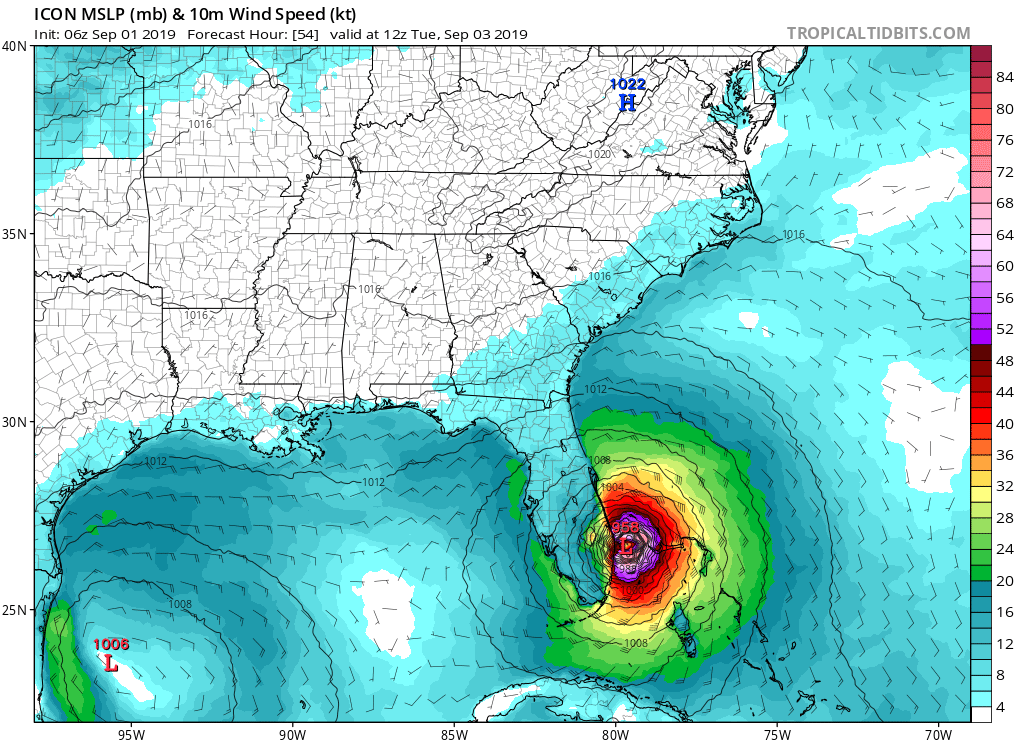
gatorcane wrote:06 ICON is slightly west of 00Z and more NE of yesterday’s runs:
https://i.postimg.cc/LsfPMPbz/icon-mslp-wind-seus-19.png
What direction is icon going at this point? Is it stalling?
0 likes
-
Shell Mound
- Category 5

- Posts: 2432
- Age: 33
- Joined: Thu Sep 07, 2017 3:39 pm
- Location: St. Petersburg, FL → Scandinavia
Re: ATL: DORIAN - Models
06Z ICON shows landfall near Stuart, FL
0 likes
CVW / MiamiensisWx / Shell Mound
The posts in this forum are NOT official forecasts and should not be used as such. They are just the opinion of the poster and may or may not be backed by sound meteorological data. They are NOT endorsed by any professional institution or STORM2K. For official information, please refer to products from the NHC and NWS.

Re: ATL: DORIAN - Models
Another just 4 hours of sleep last night, waking up to not so great news 
According to the latest 06 Euro, hurricane force wind gusts for the Treasure Coast Tuesday late morning and early afternoon.

According to the latest 06 Euro, hurricane force wind gusts for the Treasure Coast Tuesday late morning and early afternoon.
2 likes

-
HurricaneFrances04
- Category 2
- Posts: 597
- Joined: Mon Jun 25, 2012 8:09 am
- Location: Fort Lauderdale, Florida
Re: ATL: DORIAN - Models
That is a noticeable enough shift by the 6Z Euro. The 0Z had the 60 mph gusts offshore of Palm Beach.
20 to 30 miles isn't a big difference 36 hours out, but it can mean very different conditions.
20 to 30 miles isn't a big difference 36 hours out, but it can mean very different conditions.
1 likes
-
chris_fit

- Category 5
- Posts: 3261
- Age: 43
- Joined: Wed Sep 10, 2003 11:58 pm
- Location: Tampa Bay Area, FL
Re: ATL: DORIAN - Models
Just a reminder, this thing is forecast to stall out for 1.5+ days on the Bahamas.... that would be 72 hours from now - Forecast error at 72 hours is over 100 miles..... Just Sayin'
5 likes
-
Blown Away

- S2K Supporter
- Posts: 10253
- Joined: Wed May 26, 2004 6:17 am
Re: ATL: DORIAN - Models
12z TVCN shifted W again. Also the Clipper went from recurve to NW landfall, just says climatology favors a landfall over recurve now.
1 likes
Hurricane Eye Experience: David 79, Irene 99, Frances 04, Jeanne 04, Wilma 05… Hurricane Brush Experience: Andrew 92, Erin 95, Floyd 99, Matthew 16, Irma 17, Ian 22, Nicole 22…
Re: ATL: DORIAN - Models
I'm hoping for an OTS track, but I'm getting a bit nervous tbh. Can't imagine what people in the region and officials are going through right now, still so much uncertainty at this point about the possibility of a landfall. No matter what happens, I think this will be a storm I and most other people on this forum will remember for quite a few years, because of its erratic behavior and constant windshield wiping by models, especially a few days ago.
0 likes
Re: ATL: DORIAN - Models
06z Euro loop, shows hurricane force winds in gusts along the coast from Jupiter on north.

1 likes
-
seahawkjd
- S2K Supporter
- Posts: 632
- Joined: Wed Sep 10, 2003 4:12 pm
- Location: Morehead City, NC
- Contact:
Re: ATL: DORIAN - Models
What does the 6Z Euro do in relation to NC?
1 likes
Gloria, Hugo, Emily, Bertha, Bonnie, Dennis (twice), Fran, Floyd, Isabel, Irene, Arthur, Matthew, Florence, Dorian (and many tropical storms and nor'easters).
-
drewschmaltz
- S2K Supporter
- Posts: 351
- Joined: Thu Aug 27, 2015 8:19 pm
Re: ATL: DORIAN - Models
kevin wrote:I'm hoping for an OTS track, but I'm getting a bit nervous tbh. Can't imagine what people in the region and officials are going through right now, still so much uncertainty at this point about the possibility of a landfall. No matter what happens, I think this will be a storm I and most other people on this forum will remember for quite a few years, because of its erratic behavior and constant windshield wiping by models, especially a few days ago.
Hate to be the sensitive guy in the group but... My friends in Hope Town Bahamas would be confused by "OTS". The next 48 hours will change their lives. And have the models really moved that much? Or, is the downstream effect just greater because of the shape of the US coastline VS forecasted track.?
1 likes
I HAVE ABSOLUTELY NO IDEA WHAT I'M TALKING ABOUT. PLEASE CONSULT SOMEONE WHO DOES. START WITH THE NHC. ALL POSTS ARE FOR ENTERTAINMENT PURPOSES ONLY.
-
Blown Away
- S2K Supporter
- Posts: 10253
- Joined: Wed May 26, 2004 6:17 am
Re: ATL: DORIAN - Models
Tailspin wrote:https://i.imgur.com/cJAJHPC.png?1
Hmmm, 06z Euro goes inland over GA/SC vs sharp turn, usually means sensing higher pressure.
0 likes
Hurricane Eye Experience: David 79, Irene 99, Frances 04, Jeanne 04, Wilma 05… Hurricane Brush Experience: Andrew 92, Erin 95, Floyd 99, Matthew 16, Irma 17, Ian 22, Nicole 22…
-
hurricaneCW
- Category 5
- Posts: 1799
- Joined: Wed Mar 03, 2010 6:20 am
- Location: Toms River, NJ
Re: ATL: DORIAN - Models
Blown Away wrote:Tailspin wrote:https://i.imgur.com/cJAJHPC.png?1
Hmmm, 06z Euro goes inland over GA/SC vs sharp turn, usually means sensing higher pressure.
It's an individual ensemble track.
1 likes
Who is online
Users browsing this forum: No registered users and 7 guests