

ATL: DORIAN - Post-Tropical - Discussion
Moderator: S2k Moderators
Re: ATL: DORIAN - Hurricane - Discussion
So how deep is that water?
0 likes
Very useful information on the Dvorak Technique --
https://severe.worldweather.wmo.int/TCF ... kBeven.pdf
https://severe.worldweather.wmo.int/TCF ... kBeven.pdf
-
supercane4867
- Category 5

- Posts: 4966
- Joined: Wed Nov 14, 2012 10:43 am


-
AutoPenalti
- Category 5
- Posts: 4091
- Age: 29
- Joined: Mon Aug 17, 2015 4:16 pm
- Location: Ft. Lauderdale, Florida
Re: ATL: DORIAN - Hurricane - Discussion
NDG wrote:I hope Jim Edds who went to Elbow Cay thinking that the eye was going to go north of him not thinking that it would go directly over him is OK and alive, the eye right over the Cay right now, he has not reported on twitter in over 3 hours now.
https://i.imgur.com/BgDJvZA.gif
Are my eyes playing with me or has that slowed down considerably...?
0 likes
The posts in this forum are NOT official forecasts and should not be used as such. They are just the opinion of the poster and may or may not be backed by sound meteorological data. They are NOT endorsed by any professional institution or STORM2K. For official information, please refer to products from the NHC and NWS.
Model Runs Cheat Sheet:
GFS (5:30 AM/PM, 11:30 AM/PM)
HWRF, GFDL, UKMET, NAVGEM (6:30-8:00 AM/PM, 12:30-2:00 AM/PM)
ECMWF (1:45 AM/PM)
TCVN is a weighted averaged
-
HurricaneEnzo

- Category 2

- Posts: 744
- Joined: Wed Mar 14, 2018 12:18 pm
- Location: Newport, NC (Hurricane Alley)
Re: RE: Re: ATL: DORIAN - Hurricane - Discussion
Tied strongest in Atlantic only behind Haiyan and Meranti worldwide.Highteeld wrote:160 knot landfall makes it the 2nd strongest land falling storm in recorded history, no?
Sent from my SM-N975U using Tapatalk
Last edited by HurricaneEnzo on Sun Sep 01, 2019 11:52 am, edited 1 time in total.
1 likes
Bertha 96' - Fran 96' - Bonnie 98' - Dennis 99' - Floyd 99' - Isabel 03' - Alex 04' - Ophelia 05' - Irene 11' - Arthur 14' - Matthew 16' - Florence 18' - Dorian 19' - Isaias 20' (countless other tropical storms and Hurricane swipes)
I am not a Professional Met just an enthusiast. Get your weather forecasts from the Pros!
I am not a Professional Met just an enthusiast. Get your weather forecasts from the Pros!
Re: ATL: DORIAN - Hurricane - Discussion
Hypercane_Kyle wrote:Highteeld wrote:160 knot landfall makes it the 2nd strongest land falling storm in recorded history, no?
*the* strongest, tied with the Labor Day hurricane.
Haiyan at 165 should be the record
0 likes
Very useful information on the Dvorak Technique --
https://severe.worldweather.wmo.int/TCF ... kBeven.pdf
https://severe.worldweather.wmo.int/TCF ... kBeven.pdf
ATL: DORIAN - Hurricane - Discussion
I hope Tolakram posts a high definition satellite image...
I want to capture it and save it...
I want to capture it and save it...
4 likes

Re: ATL: DORIAN - Hurricane - Discussion
I never thought I would live to see Labor Day 35 matched. There are no words.
8 likes
-
Hypercane_Kyle

- Category 5
- Posts: 3465
- Joined: Sat Mar 07, 2015 7:58 pm
- Location: Cape Canaveral, FL
Re: ATL: DORIAN - Hurricane - Discussion
Highteeld wrote:Hypercane_Kyle wrote:Highteeld wrote:160 knot landfall makes it the 2nd strongest land falling storm in recorded history, no?
*the* strongest, tied with the Labor Day hurricane.
Haiyan at 165 should be the record
Sorry, meant as far as the Atlantic goes -- 2nd overall behind Haiyan in 2013.
0 likes
My posts are my own personal opinion, defer to the National Hurricane Center (NHC) and other NOAA products for decision making during hurricane season.


Re: ATL: DORIAN - Hurricane - Discussion
That youtube 'live feed' I posted was a loop someone posted to get hits. Sorry about that.
What a day. The Bahamas will not forget this. Hopefully everyone is staying as safe as possible out there.
What a day. The Bahamas will not forget this. Hopefully everyone is staying as safe as possible out there.
Last edited by Jr0d on Sun Sep 01, 2019 11:56 am, edited 1 time in total.
3 likes
Re: ATL: DORIAN - Hurricane - Discussion
TheDreamTraveler wrote:Latest advisory has Dorian moving at 8mph instead of 7mph now still due west...I thought it was supposed to slow down? I feel like a 1mph change can make a difference here.
Better hope it starts a wnw direction change soon.
0 likes

Re: ATL: DORIAN - Hurricane - Discussion
Highteeld wrote:Hypercane_Kyle wrote:Highteeld wrote:160 knot landfall makes it the 2nd strongest land falling storm in recorded history, no?
*the* strongest, tied with the Labor Day hurricane.
Haiyan at 165 should be the record
So it can still get the record with all the other landfalls that he has left to make.
0 likes
Personal Forecast Disclaimer:
The posts in this forum are NOT official forecast and should not be used as such. They are just the opinion of the poster and may or may not be backed by sound meteorological data. They are NOT endorsed by any professional institution or storm2k.org. For official information, please refer to the NHC and NWS products.
The posts in this forum are NOT official forecast and should not be used as such. They are just the opinion of the poster and may or may not be backed by sound meteorological data. They are NOT endorsed by any professional institution or storm2k.org. For official information, please refer to the NHC and NWS products.
-
eastcoastFL

- Category 5
- Posts: 3996
- Age: 44
- Joined: Thu Apr 12, 2007 12:29 pm
- Location: Palm City, FL
Re: ATL: DORIAN - Hurricane - Discussion
AutoPenalti wrote:NDG wrote:I hope Jim Edds who went to Elbow Cay thinking that the eye was going to go north of him not thinking that it would go directly over him is OK and alive, the eye right over the Cay right now, he has not reported on twitter in over 3 hours now.
https://i.imgur.com/BgDJvZA.gif
Are my eyes playing with me or has that slowed down considerably...?
Per nhc it’s moving faster now at 8mph
0 likes
Personal Forecast Disclaimer:
The posts in this forum are NOT official forecast and should not be used as such. They are just the opinion of the poster and may or may not be backed by sound meteorological data. They are NOT endorsed by any professional institution or storm2k.org. For official information, please refer to the NHC and NWS products.
The posts in this forum are NOT official forecast and should not be used as such. They are just the opinion of the poster and may or may not be backed by sound meteorological data. They are NOT endorsed by any professional institution or storm2k.org. For official information, please refer to the NHC and NWS products.
-
supercane4867
- Category 5
- Posts: 4966
- Joined: Wed Nov 14, 2012 10:43 am
Re: ATL: DORIAN - Hurricane - Discussion
URNT12 KNHC 011648
VORTEX DATA MESSAGE AL052019
A. 01/16:23:30Z
B. 26.50 deg N 076.93 deg W
C. 700 mb 2324 m
D. 913 mb
E. 280 deg 18 kt
F. CLOSED
G. C13
H. 171 kt
I. 131 deg 6 nm 16:21:30Z
J. 229 deg 154 kt
K. 131 deg 7 nm 16:21:00Z
L. 177 kt
M. 341 deg 9 nm 16:27:00Z
N. 073 deg 161 kt
O. 343 deg 10 nm 16:27:30Z
P. 8 C / 3057 m
Q. 24 C / 3044 m
R. 4 C / NA
S. 12345 / 7
T. 0.02 / 1 nm
U. AF302 2805A DORIAN OB 30
MAX FL WIND 161 KT 343 / 10 NM 16:27:30Z
Last edited by supercane4867 on Sun Sep 01, 2019 11:56 am, edited 1 time in total.
0 likes
-
storminabox
- Category 1

- Posts: 263
- Joined: Sun Jul 09, 2017 10:50 pm
Re: ATL: DORIAN - Hurricane - Discussion
Hurricane Dorian’s max potential has been realized... this is a very scary situation for the Bahamas. I never thought I’d see it reach anywhere near this intensity
0 likes
Re: ATL: DORIAN - Hurricane - Discussion
Ken711 wrote:TheDreamTraveler wrote:Latest advisory has Dorian moving at 8mph instead of 7mph now still due west...I thought it was supposed to slow down? I feel like a 1mph change can make a difference here.
Better hope it starts a wnw direction change soon.
It would soon have to start moving NW to get to where these models say he is going to go, he is moving WSW right now, I know just barely but he is moving south of west.
4 likes
Personal Forecast Disclaimer:
The posts in this forum are NOT official forecast and should not be used as such. They are just the opinion of the poster and may or may not be backed by sound meteorological data. They are NOT endorsed by any professional institution or storm2k.org. For official information, please refer to the NHC and NWS products.
The posts in this forum are NOT official forecast and should not be used as such. They are just the opinion of the poster and may or may not be backed by sound meteorological data. They are NOT endorsed by any professional institution or storm2k.org. For official information, please refer to the NHC and NWS products.

Re: ATL: DORIAN - Hurricane - Discussion
storminabox wrote:Hurricane Dorian’s max potential has been realized... this is a very scary situation for the Bahamas. I never thought I’d see it reach anywhere near this intensity
you sure? still on path to go over the Gulf Stream...
0 likes
Just like Jon Snow..."I know nothing" except what I know, and most of what I know is gathered by the fine people of the NHC
-
supercane4867
- Category 5
- Posts: 4966
- Joined: Wed Nov 14, 2012 10:43 am
Re: ATL: DORIAN - Hurricane - Discussion
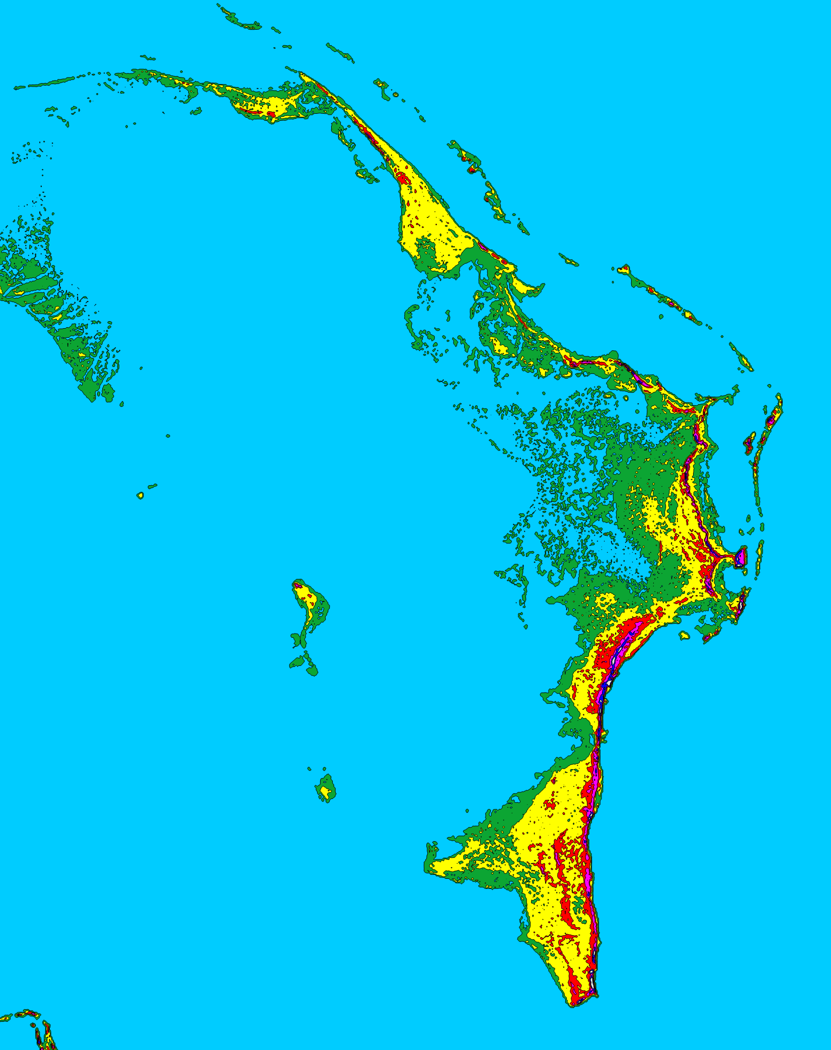
What a 25ft storm surge can do to the Abaco Islands. All area in green would be inundated
Last edited by supercane4867 on Sun Sep 01, 2019 11:58 am, edited 1 time in total.
3 likes
Re: ATL: DORIAN - Hurricane - Discussion
storminabox wrote:Hurricane Dorian’s max potential has been realized... this is a very scary situation for the Bahamas. I never thought I’d see it reach anywhere near this intensity
Why do you say he has reached it's max potential, there is still really nothing to hinder or reduce him in the near future, he still has the Gulf Stream to get additional energy.
1 likes
Personal Forecast Disclaimer:
The posts in this forum are NOT official forecast and should not be used as such. They are just the opinion of the poster and may or may not be backed by sound meteorological data. They are NOT endorsed by any professional institution or storm2k.org. For official information, please refer to the NHC and NWS products.
The posts in this forum are NOT official forecast and should not be used as such. They are just the opinion of the poster and may or may not be backed by sound meteorological data. They are NOT endorsed by any professional institution or storm2k.org. For official information, please refer to the NHC and NWS products.
Re: ATL: DORIAN - Hurricane - Discussion
Does anyone have a link they will share to closeup satellite loops with latitude and longitude lines? I've been googling like crazy and can't find any although I've seen a few loops posted here as attachments. Thanks in advance.
0 likes
Personal Forecast Disclaimer:
The posts in this forum are NOT official forecasts and should not be used as such. They are just the opinion of the poster and may or may not be backed by sound meteorological data. They are NOT endorsed by any professional institution or storm2k.org. For official information, please refer to the NHC and NWS products.
The posts in this forum are NOT official forecasts and should not be used as such. They are just the opinion of the poster and may or may not be backed by sound meteorological data. They are NOT endorsed by any professional institution or storm2k.org. For official information, please refer to the NHC and NWS products.
Re: ATL: DORIAN - Hurricane - Discussion
AutoPenalti wrote:NDG wrote:I hope Jim Edds who went to Elbow Cay thinking that the eye was going to go north of him not thinking that it would go directly over him is OK and alive, the eye right over the Cay right now, he has not reported on twitter in over 3 hours now.
https://i.imgur.com/BgDJvZA.gif
Are my eyes playing with me or has that slowed down considerably...?
According to recon it's still moving west at 8 mph. Don't see much change there. If it doesn't slow
down and turn more north over night, all hell is going to break loose.
1 likes
Who is online
Users browsing this forum: No registered users and 44 guests