
Radar showing the entire SW quad collapsing now.
Seeing CAPE over FL at about 1000, stable air.
Dorian is choking.
ATL: DORIAN - Post-Tropical - Discussion
Moderator: S2k Moderators

Re: ATL: DORIAN - Hurricane - Discussion
dspguy wrote:hipshot wrote:supercane4867 wrote:WOW this is insane. Like 70% of the island is gone???
I don't know about "gone" but it is certainly flooded.
Gone isn't entirely inaccurate. If the ocean washes over an island due to rising water levels or sinking land, it is "gone" from our terrestrial viewpoint.
But yeah, the water will recede back to the ocean. I do wonder how much the coastline eroded though.
I can only imagine the level of erosion, completely filled channels and cuts, and newly created cuts that the ocean surge and wind must have created. I'm guessing there must be newly created islands where continuous land/road previously existed which will only further hamper rescue and evacuation efforts.
0 likes
Andy D
(For official information, please refer to the NHC and NWS products.)
(For official information, please refer to the NHC and NWS products.)

Re: ATL: DORIAN - Hurricane - Discussion
Time to start nowcasting to see how close or how far away from the FL coast Dorian will track over the next 36 hours. Heights are beginning to go up over the Carolinas momentarily before the next short wave knocks them down again, how strong that temporary narrow ridge builds during the day today and night will dictate how close it will get to our FL coast tonight, so now that Dorian's core is weaker the hurricane force winds at least in gusts could get closer to our coast.The incoming trough will finish opening up the path for Dorian to track towards the Carolinas.

6 likes
-
northjaxpro

- S2K Supporter

- Posts: 8900
- Joined: Mon Sep 27, 2010 11:21 am
- Location: Jacksonville, FL
Re: ATL: DORIAN - Hurricane - Discussion
HurricaneEnzo wrote:While there is a lot of dry air around this looks to be upwelling induced more than anything.
No doiubt . It is a combination of both.upwelling and dry air entrainment from the west contributing in collapsing the western quad of the inner core..
3 likes
NEVER, EVER SAY NEVER in the tropics and weather in general, and most importantly, with life itself!!
________________________________________________________________________________________
Fay 2008 Beryl 2012 Debby 2012 Colin 2016 Hermine 2016 Julia 2016 Matthew 2016 Irma 2017 Dorian 2019
________________________________________________________________________________________
Fay 2008 Beryl 2012 Debby 2012 Colin 2016 Hermine 2016 Julia 2016 Matthew 2016 Irma 2017 Dorian 2019
-
northjaxpro
- S2K Supporter
- Posts: 8900
- Joined: Mon Sep 27, 2010 11:21 am
- Location: Jacksonville, FL
Re: ATL: DORIAN - Hurricane - Discussion
Yeah I am still concerned about a last surprise shift west in the next 24-36 hours. Any shift west would bring hurricane wind gusts closer to the Northeast Florida Coast. Really watching this like a hawk NDG.
6 likes
NEVER, EVER SAY NEVER in the tropics and weather in general, and most importantly, with life itself!!
________________________________________________________________________________________
Fay 2008 Beryl 2012 Debby 2012 Colin 2016 Hermine 2016 Julia 2016 Matthew 2016 Irma 2017 Dorian 2019
________________________________________________________________________________________
Fay 2008 Beryl 2012 Debby 2012 Colin 2016 Hermine 2016 Julia 2016 Matthew 2016 Irma 2017 Dorian 2019

Re: ATL: DORIAN - Hurricane - Discussion
CronkPSU wrote:11:00 AM EDT Tue Sep 3
Location: 27.1°N 78.6°W
Moving: NW at 2 mph
Min pressure: 955 mb
Max sustained: 110 mph
It's speed doubled!
13 likes
-
Hypercane_Kyle

- Category 5

- Posts: 3465
- Joined: Sat Mar 07, 2015 7:58 pm
- Location: Cape Canaveral, FL
Re: ATL: DORIAN - Hurricane - Discussion
Classic upwelling. A lot like the more intense typhoons in the WPAC that get stalled out. I wouldn't be surprised if it can restrengthen back to a Cat 3 on its way north, but overall the trend should be weaker.
3 likes
My posts are my own personal opinion, defer to the National Hurricane Center (NHC) and other NOAA products for decision making during hurricane season.

Re: ATL: DORIAN - Hurricane - Discussion
northjaxpro wrote:Yeah I am still concerned about a last surprise shift west in the next 36 hours. Any shift west would bring hurricane wind gusts closer to the Northeast Florida Coast. Really watching this like a hawk NDG.
You are not alone with concerns. A 'temporary' ridge is supposed to build in today before the next trough sweeps Dorian away. It won't take much of a wobble west to seriously affect Florida.
Last edited by Jr0d on Tue Sep 03, 2019 10:40 am, edited 1 time in total.
2 likes

Re: ATL: DORIAN - Hurricane - Discussion
NDG wrote:Time to start nowcasting to see how close or how far away from the FL coast Dorian will track over the next 36 hours. Heights are beginning to go up over the Carolinas momentarily before the next short wave knocks them down again, how strong that temporary narrow ridge builds during the day today and night will dictate how close it will get to our FL coast tonight, so now that Dorian's core is weaker the hurricane force winds at least in gusts could get closer to our coast.The incoming trough will finish opening up the path for Dorian to track towards the Carolinas.
https://i.imgur.com/IzoYClY.gif
thanks for posting this, as someone in eastern Orange County, still worried about expanded wind field or wobbles west
1 likes
Just like Jon Snow..."I know nothing" except what I know, and most of what I know is gathered by the fine people of the NHC
-
Aric Dunn
- Category 5
- Posts: 21238
- Age: 43
- Joined: Sun Sep 19, 2004 9:58 pm
- Location: Ready for the Chase.
- Contact:
Re: ATL: DORIAN - Hurricane - Discussion
SOme ridging has nosed in up thorugh 300mb.. between the two SHort waves. slight more nw motion maybe ?


4 likes
Note: If I make a post that is brief. Please refer back to previous posts for the analysis or reasoning. I do not re-write/qoute what my initial post said each time.
If there is nothing before... then just ask
Space & Atmospheric Physicist, Embry-Riddle Aeronautical University,
I believe the sky is falling...
If there is nothing before... then just ask
Space & Atmospheric Physicist, Embry-Riddle Aeronautical University,
I believe the sky is falling...
Re: ATL: DORIAN - Hurricane - Discussion
WV imagery showing feeder band on the north taking a big hit very rapidly.
0 likes
Re: ATL: DORIAN - Hurricane - Discussion
HurricaneEnzo wrote:While there is a lot of dry air around this looks to be upwelling induced more than anything.
Yeah, according to satellite estimates, that I guess they can see through the clouds, that shallow layer body of water north of Grand Bahama cooled down into the mid to upper 70s.
4 likes
-
Aric Dunn
- Category 5
- Posts: 21238
- Age: 43
- Joined: Sun Sep 19, 2004 9:58 pm
- Location: Ready for the Chase.
- Contact:
Re: ATL: DORIAN - Hurricane - Discussion
GCANE wrote:WV imagery showing feeder band on the north taking a big hit very rapidly.
The dry air coming down the peninsula is being moderated by the convection building over land from day time heating. show up well on WV>
https://weather.cod.edu/satrad/?parms=c ... =undefined
1 likes
Note: If I make a post that is brief. Please refer back to previous posts for the analysis or reasoning. I do not re-write/qoute what my initial post said each time.
If there is nothing before... then just ask
Space & Atmospheric Physicist, Embry-Riddle Aeronautical University,
I believe the sky is falling...
If there is nothing before... then just ask
Space & Atmospheric Physicist, Embry-Riddle Aeronautical University,
I believe the sky is falling...
Re: ATL: DORIAN - Hurricane - Discussion
Hypercane_Kyle wrote:Classic upwelling. A lot like the more intense typhoons in the WPAC that get stalled out. I wouldn't be surprised if it can restrengthen back to a Cat 3 on its way north, but overall the trend should be weaker.
I think it'll hit cat 3 again but no more than that. Convection is already starting to fire again. Dorian has been nothing but a fighter it's entire life span. I hope people aren't getting lulled a bit by this current short term weakening trend. We have a long way to go.
Last edited by Vdogg on Tue Sep 03, 2019 10:40 am, edited 1 time in total.
4 likes
-
northjaxpro
- S2K Supporter
- Posts: 8900
- Joined: Mon Sep 27, 2010 11:21 am
- Location: Jacksonville, FL
Re: ATL: DORIAN - Hurricane - Discussion
The first significant outer band of Dorian.is currently impacting Saint Johns County and in particular Flagler County around Palm Coast currenty with heavy rainfall and strong winds . I am pretty sure they are bringing tropical storm force wind gusts currently.
I just had northeast wind gust to 31 mph already here at the home
station.
BTW, I have made the decision to ride out the conditions here at home. I thought seriously of leaving, but.last night' s developments and NHC taking Jax area out of the cone of uncertainty, I decided to stay. However , it still it will be some very significant impacts coming, especially the next 30 hours as Dorian makes his closest approach to Jax.
I will do my best to keep everyone abreasted to the conditions here as I am safely able to do so.
9 likes
NEVER, EVER SAY NEVER in the tropics and weather in general, and most importantly, with life itself!!
________________________________________________________________________________________
Fay 2008 Beryl 2012 Debby 2012 Colin 2016 Hermine 2016 Julia 2016 Matthew 2016 Irma 2017 Dorian 2019
________________________________________________________________________________________
Fay 2008 Beryl 2012 Debby 2012 Colin 2016 Hermine 2016 Julia 2016 Matthew 2016 Irma 2017 Dorian 2019
-
northjaxpro
- S2K Supporter
- Posts: 8900
- Joined: Mon Sep 27, 2010 11:21 am
- Location: Jacksonville, FL
Re: ATL: DORIAN - Hurricane - Discussion
Aric Dunn wrote:SOme ridging has nosed in up thorugh 300mb.. between the two SHort waves. slight more nw motion maybe ?
http://tropic.ssec.wisc.edu/real-time/atlantic/winds/wg8dlm1.GIF
http://tropic.ssec.wisc.edu/real-time/atlantic/winds/wg8dlm2.GIF
http://tropic.ssec.wisc.edu/real-time/atlantic/winds/wg8dlm4.GIF
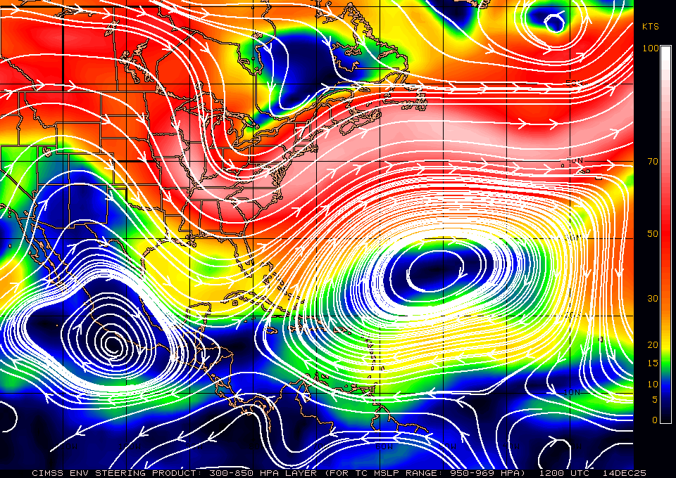
Yeah I have really been watching the CIMSS analysis very closely and yeah there is narrow ridging already takng place nosing in as you pointed out Aric. This has me very concerned that Dorian just may get close enough in the.next 24 hours to really smack our area with potential hurricane force winds and conditions , especially at the coast.
Last edited by northjaxpro on Tue Sep 03, 2019 10:48 am, edited 2 times in total.
3 likes
NEVER, EVER SAY NEVER in the tropics and weather in general, and most importantly, with life itself!!
________________________________________________________________________________________
Fay 2008 Beryl 2012 Debby 2012 Colin 2016 Hermine 2016 Julia 2016 Matthew 2016 Irma 2017 Dorian 2019
________________________________________________________________________________________
Fay 2008 Beryl 2012 Debby 2012 Colin 2016 Hermine 2016 Julia 2016 Matthew 2016 Irma 2017 Dorian 2019
Re: ATL: DORIAN - Hurricane - Discussion
I was looking at the FL beach web cams, what a difference between west coast beaches and east coast beaches, St Pete area beaches water is nice thanks to the offshore winds while straight east towards Sebastian Inlet is completely the opposite.


5 likes
Re: ATL: DORIAN - Hurricane - Discussion
Thought i'd add to the "now-cast" discussion regarding anticipated winds over East Central and Northeast Florida. Best to focus on those winds and distance from Storm center that are depicting "NW" and "SW" quadrants. Based on forecast wind radii, it appears that the immediate coastal areas from perhaps Vero all the way up to Jax, are likely to get 50 knot winds in squalls (possibly sustained conditions as well). As Dorian begins to make a NNW or NW forward motion, it would appear that the NW quadrant that would be primarily impacting inland East Central Florida (including the greater Orlando region and cities north and south from there), will not likely result in 50 knot winds (with exception to those squalls that might bring brief gusts). Inland areas however DO appear likely to still be impacted by at least 24 hours of 39 mph (min. Tropical Storm force) within the increasing number of outer bands and squalls that will be generally approaching from the north (turning to west and southwest later Wednesday as the storm pulls further north).
As noted below, the stronger 50 knots winds are only expected to reach about 60-70 miles to the west, however 34 knot winds are expected to reach between 130 - 150 miles to the west. Factors impacting small forward jogs west or east, continued weakening (or restrengthening), and/or ongoing impact of dry air being en-trained and decreasing convection over the western side of storm could impact realized conditions felt over inland and coastal Florida.
My own thoughts are that inland areas south and north of the Orlando area will experience less T.S. conditions then anticipated unless/until some more westward motion and restrengthening of the hurricane occurs.
This from the 11:00 a.m. forecast -
FORECAST VALID 04/1200Z 29.2N 79.4W
MAX WIND 95 KT...GUSTS 115 KT.
64 KT... 50NE 45SE 30SW 45NW.
50 KT... 80NE 80SE 60SW 70NW.
34 KT...150NE 150SE 90SW 130NW.
2 likes
Andy D
(For official information, please refer to the NHC and NWS products.)
(For official information, please refer to the NHC and NWS products.)
-
Aric Dunn
- Category 5
- Posts: 21238
- Age: 43
- Joined: Sun Sep 19, 2004 9:58 pm
- Location: Ready for the Chase.
- Contact:
Re: ATL: DORIAN - Hurricane - Discussion
hmmmm..... furthering the nowcasting.... I think a unforecast mid level low has formed over NE florida that is moving sw.. you can see the outflow and moisture the last couple hours all of a sudden expand ans spread to the nw..
that is interesting.. becasue if that feature is truly there thenDOrian may take a larger nw bend later as that feature drops to the SW of dorian..
keep watching. wont get to the FLorida coast but could bring it even closer.
https://weather.cod.edu/satrad/?parms=s ... =undefined
that is interesting.. becasue if that feature is truly there thenDOrian may take a larger nw bend later as that feature drops to the SW of dorian..
keep watching. wont get to the FLorida coast but could bring it even closer.
https://weather.cod.edu/satrad/?parms=s ... =undefined
6 likes
Note: If I make a post that is brief. Please refer back to previous posts for the analysis or reasoning. I do not re-write/qoute what my initial post said each time.
If there is nothing before... then just ask
Space & Atmospheric Physicist, Embry-Riddle Aeronautical University,
I believe the sky is falling...
If there is nothing before... then just ask
Space & Atmospheric Physicist, Embry-Riddle Aeronautical University,
I believe the sky is falling...
-
northjaxpro
- S2K Supporter
- Posts: 8900
- Joined: Mon Sep 27, 2010 11:21 am
- Location: Jacksonville, FL
Re: ATL: DORIAN - Hurricane - Discussion
GCANE wrote:northjaxpro wrote:Down to 110 mph Steong Cat 2.
Yeah dry airontinues getting entrained into the eestern eyewall. It is been thzt way since I woke up at 4 a.m. this morning.
Storm continues to expand as expected in size. Teopical Storm gorce winds will ecpand as far as 170 miles from the eyewall by this evening.
Hope you are breathing a bit easier JAX.
Well, only just a little bit. However GCANE, I won't feel 100% better until Dorian gets north of 30.2 N, which is Jacksonville's Latitude.
4 likes
NEVER, EVER SAY NEVER in the tropics and weather in general, and most importantly, with life itself!!
________________________________________________________________________________________
Fay 2008 Beryl 2012 Debby 2012 Colin 2016 Hermine 2016 Julia 2016 Matthew 2016 Irma 2017 Dorian 2019
________________________________________________________________________________________
Fay 2008 Beryl 2012 Debby 2012 Colin 2016 Hermine 2016 Julia 2016 Matthew 2016 Irma 2017 Dorian 2019
Who is online
Users browsing this forum: No registered users and 36 guests