All it takes is one short wave as you can see in the gfs. It’s 12 days out ridge could be gone. Let’s wait to see if something actually develops.
https://twitter.com/burgwx/status/1170731659492241408
Wave well east of Lesser Antilles (Is INVEST 96L)
Moderator: S2k Moderators
Forum rules

The posts in this forum are NOT official forecasts and should not be used as such. They are just the opinion of the poster and may or may not be backed by sound meteorological data. They are NOT endorsed by any professional institution or STORM2K. For official information, please refer to products from the National Hurricane Center and National Weather Service.
-
SFLcane

- S2K Supporter

- Posts: 10281
- Age: 48
- Joined: Sat Jun 05, 2010 1:44 pm
- Location: Lake Worth Florida
Re: Wave east of 94L
1 likes
-
Shell Mound
- Category 5

- Posts: 2432
- Age: 33
- Joined: Thu Sep 07, 2017 3:39 pm
- Location: St. Petersburg, FL → Scandinavia
Re: Wave east of 94L
LarryWx wrote:SFLcane wrote:Yeah ATL ridge gone this run.
Sure enough, much weaker WAR means a pretty easy OTS in relation to the CONUS. The 12Z GFS instead threatens Bermuda.
The 12Z GFS certainly fits the seasonal trend. Most storms thus far have had a poleward bias to the mature stages of their tracks. Given the relatively strong, persistent TUTT axis, the stable/sinking air mass over the MDR, and poleward displacement of the ITCZ (active African monsoon/wet Sahel), one should not be surprised to find that storms are mainly developing and/or intensifying to the north of the deep tropics in 2019. Fortunately, in relation to the CONUS, the Bermuda High has been considerably weaker in 2019 vs. 2016–8, despite the recent +AMO trend over the past month, thanks in part to the persistent -NAO/+PMM/+PDO regime. So the overall oceanic and atmospheric configuration has favoured troughs along or near the Eastern Seaboard in 2019. This is not enough to spare the Bahamas or eastern Caribbean from significant impacts, of course, as DORIAN amply illustrated, and it does not shield the northern Gulf Coast from BARRY-type homegrown development. But it does tend to protect the East Coast from peak-season major impacts.
3 likes
CVW / MiamiensisWx / Shell Mound
The posts in this forum are NOT official forecasts and should not be used as such. They are just the opinion of the poster and may or may not be backed by sound meteorological data. They are NOT endorsed by any professional institution or STORM2K. For official information, please refer to products from the NHC and NWS.
Re: Wave east of 94L
Unfortunately for those wanting an easy OTS with regard to the CONUS, the 12Z GEFS (based on older GFS) suggests that the 12Z GFS (FV3) has too weak a WAR and that that's an outlier. However, even so, most of the GEFS members recurve east of the CONUS. Actually, more recurve east of the CONUS than the prior 2 GEFS runs and Bermuda is threatened more (similar to yesterday's 18Z run). That being said, the very strong signal for a major TC in the western basin in ~2 weeks remains on this run.
Last edited by LarryWx on Sun Sep 08, 2019 12:41 pm, edited 1 time in total.
0 likes
Personal Forecast Disclaimer:
The posts in this forum are NOT official forecasts and should not be used as such. They are just the opinion of the poster and may or may not be backed by sound meteorological data. They are NOT endorsed by any professional institution or storm2k.org. For official information, please refer to the NHC and NWS products.
The posts in this forum are NOT official forecasts and should not be used as such. They are just the opinion of the poster and may or may not be backed by sound meteorological data. They are NOT endorsed by any professional institution or storm2k.org. For official information, please refer to the NHC and NWS products.
-
cycloneye

- Admin

- Posts: 149223
- Age: 69
- Joined: Thu Oct 10, 2002 10:54 am
- Location: San Juan, Puerto Rico
Re: Wave east of 94L
Still no mention on the 2 PM TWO but is not in the 5 day period so that is why no mention yet.
Hurricanenan,edited the title to reflect the reallity of the wave that is still inside Africa.
2 likes
Visit the Caribbean-Central America Weather Thread where you can find at first post web cams,radars
and observations from Caribbean basin members Click Here
and observations from Caribbean basin members Click Here
Re: Wave inside Africa
The 12Z GFS Legacy and CMC both are very weak and further south (in the Caribbean) than the GFS/UK.
0 likes
Personal Forecast Disclaimer:
The posts in this forum are NOT official forecasts and should not be used as such. They are just the opinion of the poster and may or may not be backed by sound meteorological data. They are NOT endorsed by any professional institution or storm2k.org. For official information, please refer to the NHC and NWS products.
The posts in this forum are NOT official forecasts and should not be used as such. They are just the opinion of the poster and may or may not be backed by sound meteorological data. They are NOT endorsed by any professional institution or storm2k.org. For official information, please refer to the NHC and NWS products.
-
gatorcane

- S2K Supporter
- Posts: 23708
- Age: 48
- Joined: Sun Mar 13, 2005 3:54 pm
- Location: Boca Raton, FL
Re: Wave inside Africa
The 10 day position from Euro and GFS. Pretty good agreement here but a completely different 500mb setup over the Western Atlantic with the Euro showing a large ridge which looks to turn the cyclone more WNW and the GFS with a trough which turns the cyclone more north:


2 likes
Re: Wave inside Africa
At 240, the 12Z Euro has a strong ridge centered just off of the US east coast, very much unlike the 12Z GFS, and the axis is close enough to it to block it and force it very slowly west 500 miles N of PR at that time. There's no telling if it would have accelerated and made it all the way to the east coast since the ridge could collapse by then. However, if the EPS has weak members near there then, it may help give us a clue.
0 likes
Personal Forecast Disclaimer:
The posts in this forum are NOT official forecasts and should not be used as such. They are just the opinion of the poster and may or may not be backed by sound meteorological data. They are NOT endorsed by any professional institution or storm2k.org. For official information, please refer to the NHC and NWS products.
The posts in this forum are NOT official forecasts and should not be used as such. They are just the opinion of the poster and may or may not be backed by sound meteorological data. They are NOT endorsed by any professional institution or storm2k.org. For official information, please refer to the NHC and NWS products.

Re: Wave inside Africa
UKmet has a weak tropical storm by hour 144
0 likes
Very useful information on the Dvorak Technique --
https://severe.worldweather.wmo.int/TCF ... kBeven.pdf
https://severe.worldweather.wmo.int/TCF ... kBeven.pdf
Re: Wave inside Africa

0 likes
Very useful information on the Dvorak Technique --
https://severe.worldweather.wmo.int/TCF ... kBeven.pdf
https://severe.worldweather.wmo.int/TCF ... kBeven.pdf
-
WeatherEmperor
- S2K Supporter
- Posts: 4806
- Age: 42
- Joined: Thu Sep 04, 2003 2:54 pm
- Location: South Florida
Re: Wave inside Africa
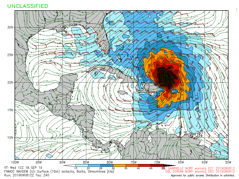
gatorcane wrote:12Z NAVGEM 240 hours:
[im://i.postimg.cc/JhSjmMwz/nvg10-sfc10m-240-go-mex.gif[/img]
Gator, can you tell what direction it is heading the last few frames on the Navgem loop? Im out of the house today so I cant pull the loops
Sent from my iPhone using Tapatalk
0 likes
-
gatorcane
- S2K Supporter
- Posts: 23708
- Age: 48
- Joined: Sun Mar 13, 2005 3:54 pm
- Location: Boca Raton, FL
Re: Wave inside Africa
WeatherEmperor wrote:gatorcane wrote:12Z NAVGEM 240 hours:
[im://i.postimg.cc/JhSjmMwz/nvg10-sfc10m-240-go-mex.gif[/url]
Gator, can you tell what direction it is heading the last few frames on the Navgem loop? Im out of the house today so I cant pull the loops
Sent from my iPhone using Tapatalk
Looks WNW
0 likes
Re: Wave inside Africa
what is the link for the 240 navgem you got there?
0 likes
Very useful information on the Dvorak Technique --
https://severe.worldweather.wmo.int/TCF ... kBeven.pdf
https://severe.worldweather.wmo.int/TCF ... kBeven.pdf
-
gatorcane
- S2K Supporter
- Posts: 23708
- Age: 48
- Joined: Sun Mar 13, 2005 3:54 pm
- Location: Boca Raton, FL
Re: Wave inside Africa
Highteeld wrote:
what is the link for the 240 navgem you got there?
https://www.fnmoc.navy.mil/wxmap_cgi/cg ... ex&set=All
1 likes

Re: Wave inside Africa
I would definitely say there are players on the field for a tropical threat. I hope it does not pan out. The pattern is sort of concerning.
0 likes
-
SFLcane
- S2K Supporter
- Posts: 10281
- Age: 48
- Joined: Sat Jun 05, 2010 1:44 pm
- Location: Lake Worth Florida
Re: Wave inside Africa
gatorcane wrote:The 10 day position from Euro and GFS. Pretty good agreement here but a completely different 500mb setup over the Western Atlantic with the Euro showing a large ridge which looks to turn the cyclone more WNW and the GFS with a trough which turns the cyclone more north:
https://i.postimg.cc/g0QnRjjv/ecmwf-mslpa-Norm-watl-11.png
.
https://i.postimg.cc/43bSH7B0/gfs-mslpa-Norm-watl-41.png
Extremely sheared on the euro...look at the 200-500mb shear maps
0 likes
-
StruThiO

- Category 3

- Posts: 821
- Age: 26
- Joined: Fri Sep 15, 2017 5:51 am
- Location: Currently Portland, OR. Raised in Jax, FL.
Re: Wave inside Africa
Looks like a potentially similar peak season steering setup to the last couple of years 
0 likes
Re: Wave inside Africa
gatorcane wrote:Highteeld wrote:
what is the link for the 240 navgem you got there?
https://www.fnmoc.navy.mil/wxmap_cgi/cg ... ex&set=All
nvm. got it to work. Thanks!
0 likes
Very useful information on the Dvorak Technique --
https://severe.worldweather.wmo.int/TCF ... kBeven.pdf
https://severe.worldweather.wmo.int/TCF ... kBeven.pdf
Re: Wave inside Africa
Stronger ridge on the 12Z EPS at hour 240 vs the 0Z EPS and similar to the 12 Euro along with a good number of members with TCs just N of PR/Hisp and E of the Bahamas, a proxy for the 12Z Euro. This will be a good test to see what portion make it to the CONUS.
0 likes
Personal Forecast Disclaimer:
The posts in this forum are NOT official forecasts and should not be used as such. They are just the opinion of the poster and may or may not be backed by sound meteorological data. They are NOT endorsed by any professional institution or storm2k.org. For official information, please refer to the NHC and NWS products.
The posts in this forum are NOT official forecasts and should not be used as such. They are just the opinion of the poster and may or may not be backed by sound meteorological data. They are NOT endorsed by any professional institution or storm2k.org. For official information, please refer to the NHC and NWS products.
Re: Wave inside Africa
LarryWx wrote:Stronger ridge on the 12Z EPS at hour 240 vs the 0Z EPS and similar to the 12 Euro along with a good number of members with TCs just N of PR/Hisp and E of the Bahamas, a proxy for the 12Z Euro. This will be a good test to see what portion make it to the CONUS.
And here are the results of the test/what ended up happening further out on the 12Z EPS: That strong ridge broke down and was pretty much gone within 3 days (day 13) and thus the vast majority of those members near where the 12Z Euro had it N of PR at 240 never even made it close to the SE US. They initially mainly moved WNW a little but then quickly recurved and mainly ended up between a NC graze and west of Bermuda. Some of these ended up getting close to the NE US.
I saw at least one member near Hisp at 240 then head to FL. The biggest SE US threat came from the minority of members that were further south in the Caribbean at 240, which just about all came up into the Gulf with some as far east as near S FL. Some were far enough west in the central Gulf to imply a possible later threat as far west as LA ~9/23-4.
This all tells me that this system could end up being another very long tiring/drawn out affair similar to Dorian.
Last edited by LarryWx on Sun Sep 08, 2019 3:31 pm, edited 4 times in total.
0 likes
Personal Forecast Disclaimer:
The posts in this forum are NOT official forecasts and should not be used as such. They are just the opinion of the poster and may or may not be backed by sound meteorological data. They are NOT endorsed by any professional institution or storm2k.org. For official information, please refer to the NHC and NWS products.
The posts in this forum are NOT official forecasts and should not be used as such. They are just the opinion of the poster and may or may not be backed by sound meteorological data. They are NOT endorsed by any professional institution or storm2k.org. For official information, please refer to the NHC and NWS products.
Who is online
Users browsing this forum: No registered users and 187 guests