Wave well east of Lesser Antilles (Is INVEST 96L)
Moderator: S2k Moderators
Forum rules

The posts in this forum are NOT official forecasts and should not be used as such. They are just the opinion of the poster and may or may not be backed by sound meteorological data. They are NOT endorsed by any professional institution or STORM2K. For official information, please refer to products from the National Hurricane Center and National Weather Service.
-
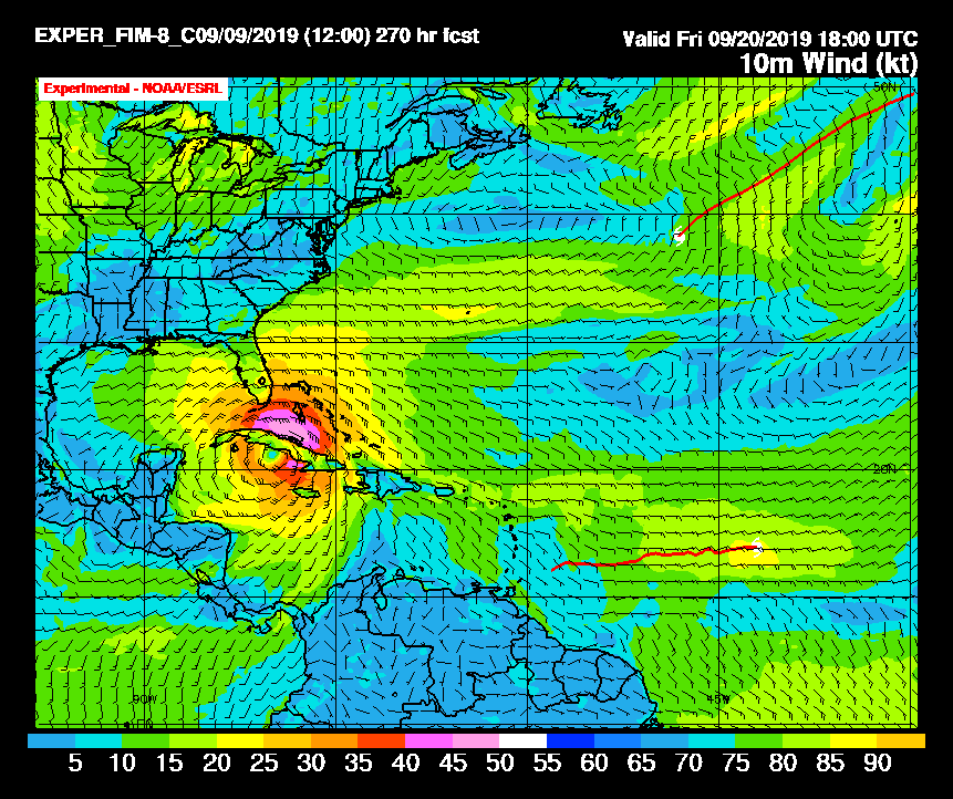
gatorcane

- S2K Supporter

- Posts: 23708
- Age: 48
- Joined: Sun Mar 13, 2005 3:54 pm
- Location: Boca Raton, FL
Re: Wave Exiting Africa
12Z FIM model long-range. Later goes on to recurve into SW Florida while intensifying:
1 likes
-
AtlanticWind

- S2K Supporter
- Posts: 1898
- Age: 67
- Joined: Sun Aug 08, 2004 9:57 pm
- Location: Plantation,Fla
Re: Wave Exiting Africa
ronjon wrote:RL3AO wrote:USTropics wrote:How the WPAC systems Lingling and Faxai are absorbed into the higher latitudes could play a crucial role in the eventual track of this AEW. Here is an analysis of the 2 systems 72 hours ago, and their eventual track towards an approaching trough:
Nothing says fall like a nice typhoon enhanced Rossby Wave train.
Complicated teleconnections you say? Models to say the least are highly uncertain. Sometimes I think all models should never go past 7 days.
It is not the models going past 7 days that is the problem,but that we tend to overhype the solutions
that far out.
But there are cases where the models have performed really well in the long range.
Look back at Irma ,they were in remarkable agreement that she would strengthen and
cross the Atlantic and threaten the leewards, Puerto Rico,Florida and the S.E. U.S.
And that was when the system was in the Cabo Verde islands
3 likes
-
ouragans

- Category 2

- Posts: 501
- Age: 54
- Joined: Sun Jun 12, 2011 12:09 pm
- Location: Abymes, Guadeloupe F.W.I
- Contact:
Re: Wave Exiting Africa
Is it this one?
GENESIS021, AL, L, , , , , 74, 2019, DB, O, 2019090800, 9999999999, , 021, , , , GENESIS, , AL742019
0 likes
Personal forecast disclaimer
This post is a personal point of view, not an information. Please refer to official statements for life-threatening decisions.
David '79, Frederic '79, Hugo '89, Iris, Luis & Marilyn '95, Georges '98, Lenny '99, Dean '07, Irma '17, Maria '17, Fiona '22, Philippe '23, Tammy '23
16°13'33.3,"6N -61°36'39.5"W
-
SFLcane

- S2K Supporter
- Posts: 10281
- Age: 48
- Joined: Sat Jun 05, 2010 1:44 pm
- Location: Lake Worth Florida
Re: Wave Exiting Africa
A good chunk about 80% of the ECMWF eps members are recurving near Bermuda.
0 likes
-
Hurricaneman

- Category 5

- Posts: 7404
- Age: 45
- Joined: Tue Aug 31, 2004 3:24 pm
- Location: central florida
Re: Wave Exiting Africa
ouragans wrote:Is it this one?GENESIS021, AL, L, , , , , 74, 2019, DB, O, 2019090800, 9999999999, , 021, , , , GENESIS, , AL742019
Yep, they’re doing an internal invest like they usually do before they do a public invest
1 likes

Re: Wave Exiting Africa
SFLcane wrote:A good chunk about 80% of the ECMWF eps members are recurving near Bermuda.
Do you have a graphic link?
0 likes
Igor 2010, Sandy 2012, Fay 2014, Gonzalo 2014, Joaquin 2015, Nicole 2016, Humberto 2019, Imelda 2025
I am only a tropical weather enthusiast. My predictions are not official and may or may not be backed by sound meteorological data. For official information, please refer to the NHC and NWS products.
I am only a tropical weather enthusiast. My predictions are not official and may or may not be backed by sound meteorological data. For official information, please refer to the NHC and NWS products.
Re: Wave Exiting Africa
0z GFS development significantly delayed. Good news for islands, if true
0 likes
-
Hurricaneman
- Category 5
- Posts: 7404
- Age: 45
- Joined: Tue Aug 31, 2004 3:24 pm
- Location: central florida
Re: Wave Exiting Africa
sma10 wrote:0z GFS development significantly delayed. Good news for islands, if true
The thing is the GFS has been inconsistent on intensity with this feature, who knows it could be a quicker developing system than modeled but also may never develop so we’ll have to wait and see
0 likes
Re: Wave Exiting Africa
Hurricaneman wrote:sma10 wrote:0z GFS development significantly delayed. Good news for islands, if true
The thing is the GFS has been inconsistent on intensity with this feature, who knows it could be a quicker developing system than modeled but also may never develop so we’ll have to wait and see
As suspected though, delayed development does not necessarily guarantee good news for U.S.
0 likes
Re: Wave Exiting Africa
1. The 0Z Euro is weak and much further south in the Caribbean.
2. The 0Z CMC is faster and stronger skirting N Hisp.
2. The 0Z CMC is faster and stronger skirting N Hisp.
0 likes
Personal Forecast Disclaimer:
The posts in this forum are NOT official forecasts and should not be used as such. They are just the opinion of the poster and may or may not be backed by sound meteorological data. They are NOT endorsed by any professional institution or storm2k.org. For official information, please refer to the NHC and NWS products.
The posts in this forum are NOT official forecasts and should not be used as such. They are just the opinion of the poster and may or may not be backed by sound meteorological data. They are NOT endorsed by any professional institution or storm2k.org. For official information, please refer to the NHC and NWS products.


Re: Wave Exiting Africa
0 likes
-
plasticup
Re: Wave Exiting Africa
drezee wrote:Very little doubt of a closed surface low...
https://earth.nullschool.net/#current/w ... 690,12.085
If that map is accurate we'll have an invest today.
0 likes
-
SFLcane
- S2K Supporter
- Posts: 10281
- Age: 48
- Joined: Sat Jun 05, 2010 1:44 pm
- Location: Lake Worth Florida
Re: Wave Exiting Africa
plasticup wrote:drezee wrote:Very little doubt of a closed surface low...
https://earth.nullschool.net/#current/w ... 690,12.085
If that map is accurate we'll have an invest today.
That map is just model analysis winds. It's not direct obs. I don’t expect a tag for several days if at all.
2 likes
-
wxman57

- Moderator-Pro Met

- Posts: 23171
- Age: 68
- Joined: Sat Jun 21, 2003 8:06 pm
- Location: Houston, TX (southwest)
Re: Wave Exiting Africa
plasticup wrote:drezee wrote:Very little doubt of a closed surface low...
https://earth.nullschool.net/#current/w ... 690,12.085
If that map is accurate we'll have an invest today.
There are no specific requirements for the NHC declaring an "Invest". At any time, for any reason, they can decide to run models on a disturbance of interest. There may be little chance of the disturbance developing, or it may already have developed an LLC. Based on quite a bit of model support for development, and the fact that it may reach the NE Caribbean in 6 days, I would suspect it will become 95L today.
5 likes
-
ouragans
- Category 2
- Posts: 501
- Age: 54
- Joined: Sun Jun 12, 2011 12:09 pm
- Location: Abymes, Guadeloupe F.W.I
- Contact:
Re: Wave Exiting Africa
Generally, and there's no rule for this, Invest are declared when NHC is at 20% for 48 hrs. But sometimes, there's an invest with 0% or 10%, or even 30%
0 likes
Personal forecast disclaimer
This post is a personal point of view, not an information. Please refer to official statements for life-threatening decisions.
David '79, Frederic '79, Hugo '89, Iris, Luis & Marilyn '95, Georges '98, Lenny '99, Dean '07, Irma '17, Maria '17, Fiona '22, Philippe '23, Tammy '23
16°13'33.3,"6N -61°36'39.5"W
This post is a personal point of view, not an information. Please refer to official statements for life-threatening decisions.
David '79, Frederic '79, Hugo '89, Iris, Luis & Marilyn '95, Georges '98, Lenny '99, Dean '07, Irma '17, Maria '17, Fiona '22, Philippe '23, Tammy '23
16°13'33.3,"6N -61°36'39.5"W
Re: Wave in Far Eastern Atlantic
12z GFS back to being strong again.
1 likes
Igor 2010, Sandy 2012, Fay 2014, Gonzalo 2014, Joaquin 2015, Nicole 2016, Humberto 2019, Imelda 2025
I am only a tropical weather enthusiast. My predictions are not official and may or may not be backed by sound meteorological data. For official information, please refer to the NHC and NWS products.
I am only a tropical weather enthusiast. My predictions are not official and may or may not be backed by sound meteorological data. For official information, please refer to the NHC and NWS products.
Re: Wave in Far Eastern Atlantic
CMC and Euro disagree slightly with GFS in bringing the wave further south and west. At this point they have the system interacting with Hispaniola and Cuba, but it doesn't take much of a SW shift to put the system in a much more perilous location south of Cuba. Something to watch with today's 12z Euro
1 likes

Re: Wave in Far Eastern Atlantic
GEM backing off a bit but it looks like a result of the track, going right over the middle of the Greater Antilles.
0 likes
The above post is not official and should not be used as such. It is the opinion of the poster and may or may not be backed by sound meteorological data. It is not endorsed by any professional institution or storm2k.org. For official information, please refer to the NHC and NWS products.
-
otowntiger
- Category 5
- Posts: 1932
- Joined: Tue Aug 31, 2004 7:06 pm
Re: Wave Exiting Africa
Agreed. I also think of Matthew in this regard. When the system was in the Cape Verdes as a tropical wave it had lots of model support for hitting/threatening Florida just as it ultimately did.AtlanticWind wrote:ronjon wrote:RL3AO wrote:
Nothing says fall like a nice typhoon enhanced Rossby Wave train.
Complicated teleconnections you say? Models to say the least are highly uncertain. Sometimes I think all models should never go past 7 days.
It is not the models going past 7 days that is the problem,but that we tend to overhype the solutions
that far out.
But there are cases where the models have performed really well in the long range.
Look back at Irma ,they were in remarkable agreement that she would strengthen and
cross the Atlantic and threaten the leewards, Puerto Rico,Florida and the S.E. U.S.
And that was when the system was in the Cabo Verde islands
0 likes
Who is online
Users browsing this forum: No registered users and 127 guests