Tropical Wave in Central Tropical Atlantic (Is INVEST 97L)
Moderator: S2k Moderators
Forum rules

The posts in this forum are NOT official forecasts and should not be used as such. They are just the opinion of the poster and may or may not be backed by sound meteorological data. They are NOT endorsed by any professional institution or STORM2K. For official information, please refer to products from the National Hurricane Center and National Weather Service.

Re: Tropical Wave in Central Tropical Atlantic
Very likely to be designated Invest 97L later today.
0 likes
-
Hurricaneman

- Category 5

- Posts: 7404
- Age: 45
- Joined: Tue Aug 31, 2004 3:24 pm
- Location: central florida
Re: Tropical Wave in Central Tropical Atlantic
The latest run of the GFS gets this near the Bahamas, seems like it’s trending west
0 likes
-
jlauderdal
- S2K Supporter

- Posts: 7240
- Joined: Wed May 19, 2004 5:46 am
- Location: NE Fort Lauderdale
- Contact:
Re: RE: Re: Tropical Wave in Central Tropical Atlantic
Ridge building in behind humberto, will have to monitor west trendHurricaneman wrote:The latest run of the GFS gets this near the Bahamas, seems like it’s trending west
0 likes
-
AutoPenalti
- Category 5
- Posts: 4091
- Age: 29
- Joined: Mon Aug 17, 2015 4:16 pm
- Location: Ft. Lauderdale, Florida
Re: Tropical Wave in Central Tropical Atlantic
GFS loses it in the Bahamas...
1 likes
The posts in this forum are NOT official forecasts and should not be used as such. They are just the opinion of the poster and may or may not be backed by sound meteorological data. They are NOT endorsed by any professional institution or STORM2K. For official information, please refer to products from the NHC and NWS.
Model Runs Cheat Sheet:
GFS (5:30 AM/PM, 11:30 AM/PM)
HWRF, GFDL, UKMET, NAVGEM (6:30-8:00 AM/PM, 12:30-2:00 AM/PM)
ECMWF (1:45 AM/PM)
TCVN is a weighted averaged
-
SFLcane

- S2K Supporter
- Posts: 10281
- Age: 48
- Joined: Sat Jun 05, 2010 1:44 pm
- Location: Lake Worth Florida
Re: Tropical Wave in Central Tropical Atlantic
Hurricaneman wrote:The latest run of the GFS gets this near the Bahamas, seems like it’s trending west
GFS never really develops this wave there for takes it more westerly. Odds are if intensities it most likely would recurve.
4 likes
-
TheStormExpert
Re: Tropical Wave in Central Tropical Atlantic
12z GFS looks to drop it again through at least 132hrs. 
0 likes
-
AutoPenalti
- Category 5
- Posts: 4091
- Age: 29
- Joined: Mon Aug 17, 2015 4:16 pm
- Location: Ft. Lauderdale, Florida
Re: Tropical Wave in Central Tropical Atlantic
The whole bait and switch with the GFS and some other models is getting old.
8 likes
The posts in this forum are NOT official forecasts and should not be used as such. They are just the opinion of the poster and may or may not be backed by sound meteorological data. They are NOT endorsed by any professional institution or STORM2K. For official information, please refer to products from the NHC and NWS.
Model Runs Cheat Sheet:
GFS (5:30 AM/PM, 11:30 AM/PM)
HWRF, GFDL, UKMET, NAVGEM (6:30-8:00 AM/PM, 12:30-2:00 AM/PM)
ECMWF (1:45 AM/PM)
TCVN is a weighted averaged
-
gatorcane

- S2K Supporter
- Posts: 23708
- Age: 48
- Joined: Sun Mar 13, 2005 3:54 pm
- Location: Boca Raton, FL
Re: Tropical Wave in Central Tropical Atlantic
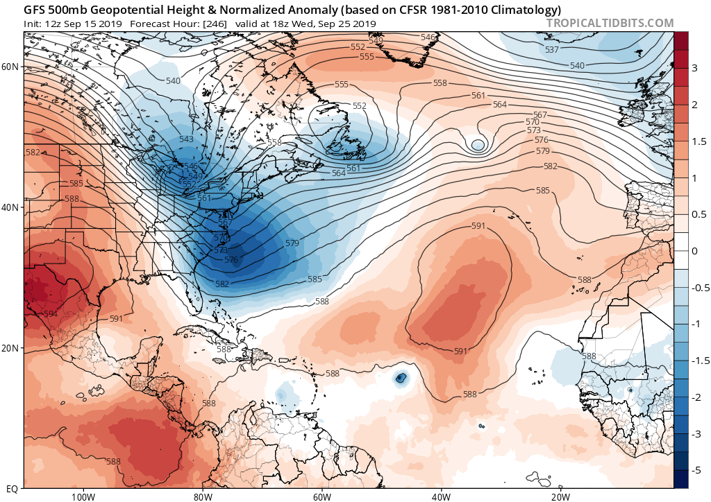
Trough after trough rolling off the east coast of the US looking a the 12Z guidance so these Cape Verde systems would likely recurve. In fact look at this one in the long-range:  of course beyond about 5 days, we always trust the models.
2 likes
-
SFLcane
- S2K Supporter
- Posts: 10281
- Age: 48
- Joined: Sat Jun 05, 2010 1:44 pm
- Location: Lake Worth Florida
Re: Tropical Wave in Central Tropical Atlantic
AutoPenalti wrote:The whole bait and switch with the GFS and some other models is getting old.
That's why can't really worry about storms til they form.
1 likes
-
SFLcane
- S2K Supporter
- Posts: 10281
- Age: 48
- Joined: Sat Jun 05, 2010 1:44 pm
- Location: Lake Worth Florida
Re: Tropical Wave in Central Tropical Atlantic
gatorcane wrote:Trough after trough rolling off the east coast of the US looking a the 12Z guidance so these Cape Verde systems would likely recurve. In fact look at this one in the long-range:
https://i.postimg.cc/fT952H0m/gfs-z500a-Norm-atl-42.png
Yeah looks like anything forming in the MDR should recurve during the next two weeks easily.
1 likes
-
cycloneye

- Admin

- Posts: 149219
- Age: 69
- Joined: Thu Oct 10, 2002 10:54 am
- Location: San Juan, Puerto Rico
Re: Tropical Wave in Central Tropical Atlantic
Up to 30/80.

A small low pressure system is producing an elongated area of
disorganized showers and thunderstorms over the central tropical
Atlantic. Slow development is anticipated during the next day or
two, but environmental conditions are forecast to become more
conducive for development by the middle of the week, and a tropical
depression is likely to form by the end of the week while the system
moves slowly west-northwestward to northwestward.
* Formation chance through 48 hours...low...30 percent.
* Formation chance through 5 days...high...80 percent.
0 likes
Visit the Caribbean-Central America Weather Thread where you can find at first post web cams,radars
and observations from Caribbean basin members Click Here
and observations from Caribbean basin members Click Here
-
cycloneye
- Admin
- Posts: 149219
- Age: 69
- Joined: Thu Oct 10, 2002 10:54 am
- Location: San Juan, Puerto Rico
Re: Tropical Wave in Central Tropical Atlantic (Is INVEST 97L)
0 likes
Visit the Caribbean-Central America Weather Thread where you can find at first post web cams,radars
and observations from Caribbean basin members Click Here
and observations from Caribbean basin members Click Here
Who is online
Users browsing this forum: Google Adsense [Bot] and 103 guests