ATL: KAREN - Models
Moderator: S2k Moderators
-
gatorcane

- S2K Supporter

- Posts: 23708
- Age: 48
- Joined: Sun Mar 13, 2005 3:54 pm
- Location: Boca Raton, FL
Re: ATL: KAREN - Models
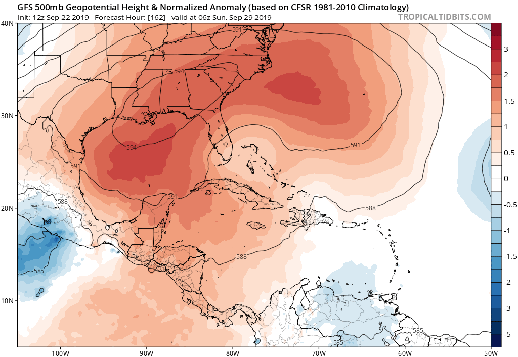
The 500MB ridge looks stronger and more expansive in a week’s this time around than with Dorian. We will see but let us hope the pronged shear by the GFS indeed develops near the Bahamas.
1 likes

Re: ATL: KAREN - Models
Hurricaneman wrote:Emmett_Brown wrote:12Z still takes it W toward Bahamas, but weakens it to a wave, due to shear from an upper low that is meandering off the SE coast throughout the run.
It’s a GFS vs Euro thing but for once not the track but intensity, the Euro has a hurricane as it heads west while the GFS barely has anything but usually storms that head west intensify so based on that I’m leaning towards the Euro but the GFS can’t be discounted if an ULL forms close by near the Bahamas and stalls
Personally I'd toss the latter GFS for now given how poorly it's done this year--Humberto was supposed to remain weak and go into the Gulf. If it survives the Caribbean in the first place then conditions seem like they'll be more favorable ahead.
0 likes
The above post is not official and should not be used as such. It is the opinion of the poster and may or may not be backed by sound meteorological data. It is not endorsed by any professional institution or storm2k.org. For official information, please refer to the NHC and NWS products.

Re: ATL: KAREN - Models
Multiple models showing Fujiwhara effect with Jerry in several days time. Good luck on any model to be remotely accurate lol.
0 likes
Very useful information on the Dvorak Technique --
https://severe.worldweather.wmo.int/TCF ... kBeven.pdf
https://severe.worldweather.wmo.int/TCF ... kBeven.pdf

Re: ATL: KAREN - Models
12Z Legacy moves Karen west but then weakens her.
12Z GEFS: I couldn’t find any members that have anything other than mainly weak though they do mainly get stuck and go west.
12Z GEFS: I couldn’t find any members that have anything other than mainly weak though they do mainly get stuck and go west.
0 likes
Personal Forecast Disclaimer:
The posts in this forum are NOT official forecasts and should not be used as such. They are just the opinion of the poster and may or may not be backed by sound meteorological data. They are NOT endorsed by any professional institution or storm2k.org. For official information, please refer to the NHC and NWS products.
The posts in this forum are NOT official forecasts and should not be used as such. They are just the opinion of the poster and may or may not be backed by sound meteorological data. They are NOT endorsed by any professional institution or storm2k.org. For official information, please refer to the NHC and NWS products.
-
toad strangler

- S2K Supporter
- Posts: 4546
- Joined: Sun Jul 28, 2013 3:09 pm
- Location: Earth
- Contact:
Re: ATL: KAREN - Models
12z Euro has a weak 1009mb L about to split PR down the middle. That's a recipe for dissipation right there along with tons of rain for the island.
0 likes
My Weather Station
https://www.wunderground.com/dashboard/pws/KFLPORTS603
https://www.wunderground.com/dashboard/pws/KFLPORTS603
-
gatorcane
- S2K Supporter
- Posts: 23708
- Age: 48
- Joined: Sun Mar 13, 2005 3:54 pm
- Location: Boca Raton, FL
Re: ATL: KAREN - Models
12Z Euro 72 hours heading north just north of PR:
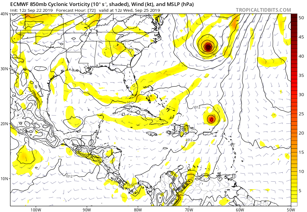
Last edited by gatorcane on Sun Sep 22, 2019 1:10 pm, edited 1 time in total.
0 likes

Re: ATL: KAREN - Models
Predicting the upcoming 72 hr. model output:
EURO - most consistent with motion and a range in intensity from zero to hurricane with eventual eastward shifts to eventual storm track
ICON - mega-bomb landfall scares ranging from P.R. to Bermuda, to Hispaniola, to Cuba, to the Bahamas, to Florida, to Texas, to Baja CA.
GFS - Partly Cloudy with a 30% chance of showers and brisk tropical trades (for everyone)
CMC - Anything.... North
NAVGEM - squirrel
NAM - Is it Hurricane Season?
Overall, model-watching during the next few days should be fun or scary to say the least. Take it with a grain of salt until whatever remnant of Karen are north of the Caribbean.
2 likes
Andy D
(For official information, please refer to the NHC and NWS products.)
(For official information, please refer to the NHC and NWS products.)
-
toad strangler
- S2K Supporter
- Posts: 4546
- Joined: Sun Jul 28, 2013 3:09 pm
- Location: Earth
- Contact:
Re: ATL: KAREN - Models
chaser1 wrote:Predicting the upcoming 72 hr. model output:
Overall, model-watching during the next few days should be fun or scary to say the least. Take it with a grain of salt until whatever remnant of Karen are north of the Caribbean.
Sounds eerily similar to another storm this year
0 likes
My Weather Station
https://www.wunderground.com/dashboard/pws/KFLPORTS603
https://www.wunderground.com/dashboard/pws/KFLPORTS603
-
gatorcane
- S2K Supporter
- Posts: 23708
- Age: 48
- Joined: Sun Mar 13, 2005 3:54 pm
- Location: Boca Raton, FL
Re: ATL: KAREN - Models
12Z Euro 96 hours heading north but looks like ridge starting to build in the wake of Jerry:
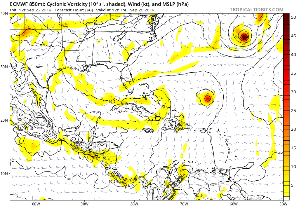
0 likes
-
gatorcane
- S2K Supporter
- Posts: 23708
- Age: 48
- Joined: Sun Mar 13, 2005 3:54 pm
- Location: Boca Raton, FL
Re: ATL: KAREN - Models
Euro 120 hours looks to be starting the turn with the ridge building: 
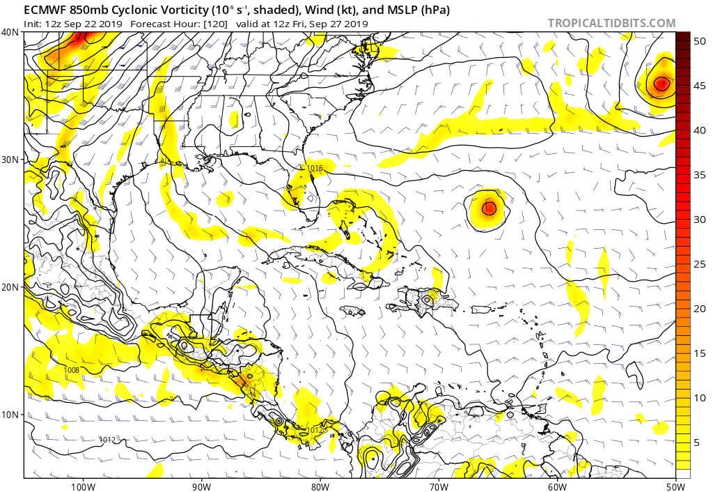
0 likes
-
Hypercane_Kyle

- Category 5

- Posts: 3465
- Joined: Sat Mar 07, 2015 7:58 pm
- Location: Cape Canaveral, FL
Re: ATL: KAREN - Models
12z ECMWF looks similar to yesterday's 12z run regarding how far north it gets.
0 likes
My posts are my own personal opinion, defer to the National Hurricane Center (NHC) and other NOAA products for decision making during hurricane season.
Re: ATL: KAREN - Models
Hypercane_Kyle wrote:12z ECMWF looks similar to yesterday's 12z run regarding how far north it gets.

0 likes
Very useful information on the Dvorak Technique --
https://severe.worldweather.wmo.int/TCF ... kBeven.pdf
https://severe.worldweather.wmo.int/TCF ... kBeven.pdf

-
toad strangler
- S2K Supporter
- Posts: 4546
- Joined: Sun Jul 28, 2013 3:09 pm
- Location: Earth
- Contact:
Re: ATL: KAREN - Models
So far through 120 hrs the 12z Euro is much weaker than 0z. Similar to the 12z GFS.
0 likes
My Weather Station
https://www.wunderground.com/dashboard/pws/KFLPORTS603
https://www.wunderground.com/dashboard/pws/KFLPORTS603
-
jlauderdal
- S2K Supporter
- Posts: 7240
- Joined: Wed May 19, 2004 5:46 am
- Location: NE Fort Lauderdale
- Contact:
Re: ATL: KAREN - Models
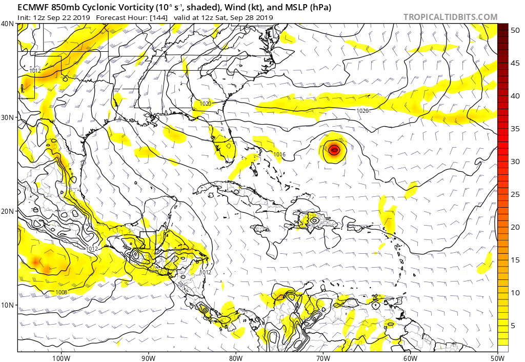
270 would be right into boca, roh rohgatorcane wrote:Starting to strengthen and the west turn has happened:
https://i.postimg.cc/8CQXChp0/ecmwf-uv850-vort-watl-7.png
0 likes
-
SpaceyLacey

- Tropical Wave

- Posts: 8
- Age: 27
- Joined: Wed Sep 18, 2019 9:50 pm

-
toad strangler
- S2K Supporter
- Posts: 4546
- Joined: Sun Jul 28, 2013 3:09 pm
- Location: Earth
- Contact:
Re: ATL: KAREN - Models
12z Euro still much weaker than 0z but that's not the key here this far out. The key is that persistent left turn which has already happened on 12z Euro.
0 likes
My Weather Station
https://www.wunderground.com/dashboard/pws/KFLPORTS603
https://www.wunderground.com/dashboard/pws/KFLPORTS603
Who is online
Users browsing this forum: No registered users and 100 guests