LarryWx wrote:12Z Euro hits central LA 234-240.
It looked like that was where the W edge of the ridge was THIS run.
Moderator: S2k Moderators


LarryWx wrote:12Z Euro hits central LA 234-240.


AubreyStorm wrote:
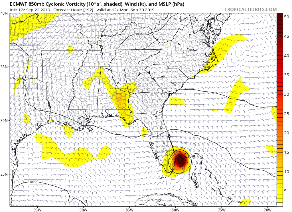
Cat 1 right?
chris_fit wrote:toad strangler wrote:For those keeping score the 12z CMC still has Karen moving N at 120 hours
And then takes it East out to sea


sma10 wrote:I'm going to have to take my anti nausea pills because of how many times I'm going to have to hear the "A" name mentioned over the next week.
AxaltaRacing24 wrote:sma10 wrote:toad strangler wrote:12z Euro still much weaker than 0z but that's not the key here this far out. The key is that persistent left turn which has already happened on 12z Euro.
Agreed. I would go even further to say being weaker is meaningless, if you want to argue over 980mb vs 998 mb. Those details this far out and strike point (miami, wpb, cuba, etc) also not important. The only thing of concern for the US is whether the Euro is "locking in" on an idea
My concern is how the euro has been committed to this turn. If it stays committed when the timeframe for a turn decreases to 3-4 days out, then we really need to watch this.
CrazyC83 wrote:This is certainly not a pattern you'd expect at the end of September or beginning of October though. That looks like a track you'd be more apt to see in August.


AubreyStorm wrote:
Cat 1 right?


AL, 12, 2019092212, 98, EMDT, 174, 263N, 747W, 55, 990, , 34, NEQ, 0, 0, 0, 0, 0, 0, 12
AL, 12, 2019092212, 98, EMDT, 240, 297N, 923W, 51, 990, , 34, NEQ, 0, 0, 0, 0, 0, 0, 10
Cunxi Huang wrote:12z EURO suggests peak intensity of 990 mb.AL, 12, 2019092212, 98, EMDT, 174, 263N, 747W, 55, 990, , 34, NEQ, 0, 0, 0, 0, 0, 0, 12
AL, 12, 2019092212, 98, EMDT, 240, 297N, 923W, 51, 990, , 34, NEQ, 0, 0, 0, 0, 0, 0, 10

WeatherEmperor wrote:Cunxi Huang wrote:12z EURO suggests peak intensity of 990 mb.AL, 12, 2019092212, 98, EMDT, 174, 263N, 747W, 55, 990, , 34, NEQ, 0, 0, 0, 0, 0, 0, 12
AL, 12, 2019092212, 98, EMDT, 240, 297N, 923W, 51, 990, , 34, NEQ, 0, 0, 0, 0, 0, 0, 10
Is this from the hi resolution Euro or the regular??
Sent from my iPhone using Tapatalk
Users browsing this forum: No registered users and 103 guests


