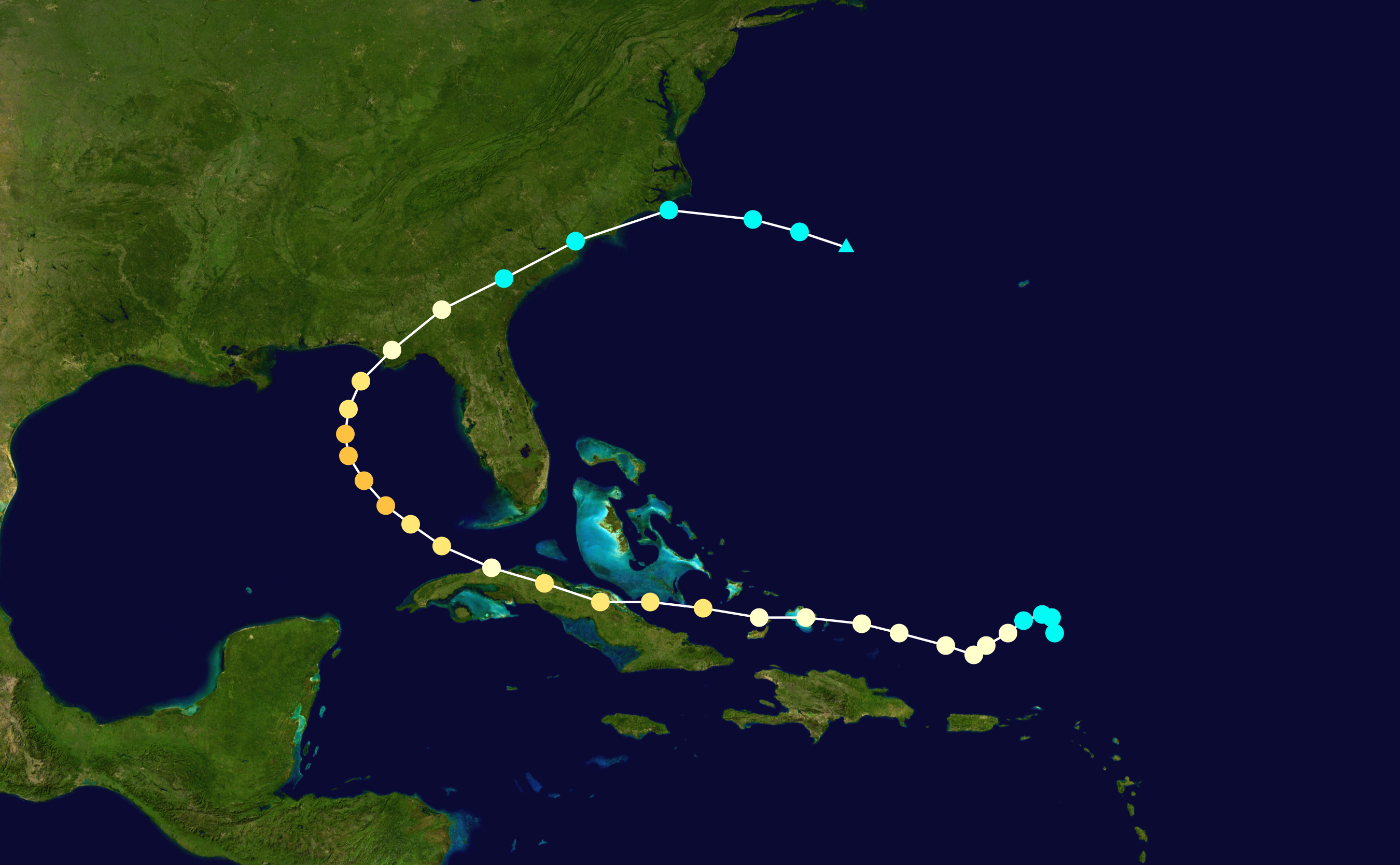
WeatherEmperor wrote:By the keys now
https://uploads.tapatalk-cdn.com/20190923/a0d60a20f11d9fd49a2100aac4bf3194.png
Sent from my iPhone using Tapatalk
Euro sticking hard to this solution. 4 solid days of south-of-west motion in late sept. Wow
Moderator: S2k Moderators
WeatherEmperor wrote:By the keys now
https://uploads.tapatalk-cdn.com/20190923/a0d60a20f11d9fd49a2100aac4bf3194.png
Sent from my iPhone using Tapatalk


sma10 wrote:AJC3 wrote:https://i.imgur.com/05BsNA6.gif
72 hour trend for SLP and 500MB height for the ECM. The model appears to have gone toward a slightly more progressive, less blocky pattern. Note the eastern CONUS/western ATLC ridge looks a little flatter and farther east, while the huge central Atlantic trough progged to catch Lorenzo-to-be has shifted eastward, allowing the TC to enter the picture.
What would the ramifications of this be, if any?
I notice that Lorenzo seems to make a sharp turn to the north mostly because Jerry's remains slow down considerably this run.

kevin wrote:Surprised to see the consistency in the models in terms of parh this early on. Let's see if it stays this way. Talking about the intensity forecast, remember Dorian. About this time period before Dorian made landfall almost all members showed a tropical storm to weak cat 1 (GFs operational even fell apart before reaching the Bahamas). Models have a hard time with the intensity of small storms and I noticed that many of the global models seem to underestimate long term intensity in general.
sma10 wrote:I think this sucker is going to make it all the way to Texas
AxaltaRacing24 wrote:sma10 wrote:I think this sucker is going to make it all the way to Texas
possibly would be mexico.
sma10 wrote:At t240 STILL going due west towards the western gulf!
Verbatim, given the time of year plus the position where the ridge captures Karen (26n, 65w), this would have to be a .... once a century type track?

AJC3 wrote:sma10 wrote:At t240 STILL going due west towards the western gulf!
Verbatim, given the time of year plus the position where the ridge captures Karen (26n, 65w), this would have to be a .... once a century type track?
More like unprecedented. Closest analog I see is Andrew, and even that didn't get sent nearly that far west. The only other system remotely in the ball park (and really not that close) is Dora (1964).
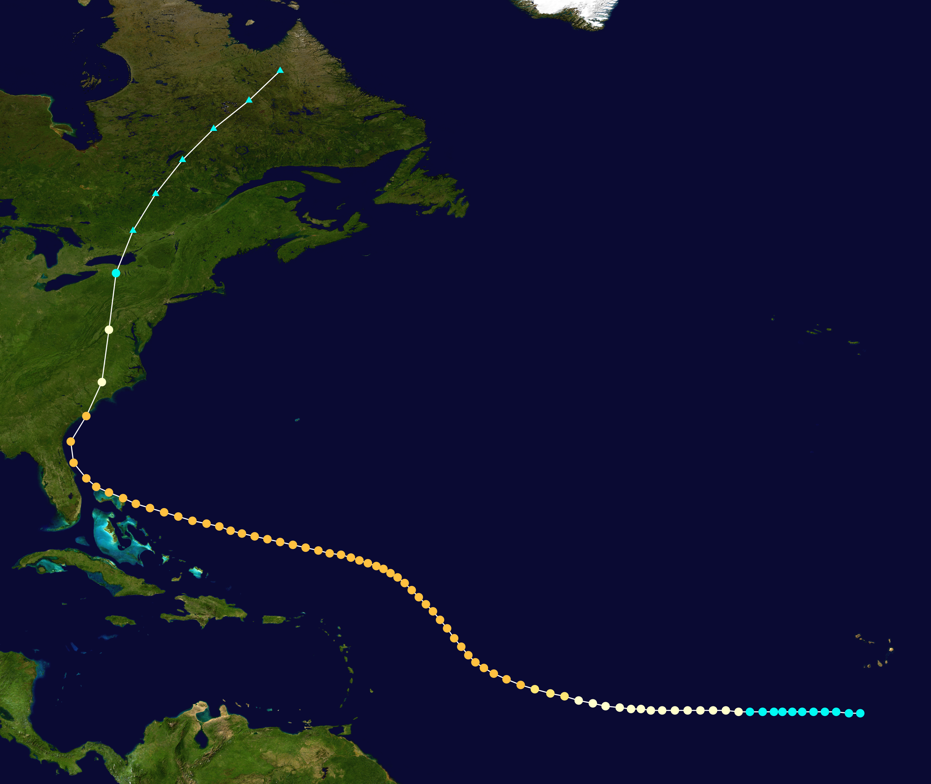
https://i.imgur.com/VZPtH4x.jpg
AJC3 wrote:sma10 wrote:At t240 STILL going due west towards the western gulf!
Verbatim, given the time of year plus the position where the ridge captures Karen (26n, 65w), this would have to be a .... once a century type track?
More like unprecedented. Closest analog I see is Andrew, and even that didn't get sent nearly that far west. The only other system remotely in the ball park (and really not that close) is Dora (1964). And for late September/early October, from a climatological standpoint, this would be pretty astounding.
https://i.imgur.com/VZPtH4x.jpg


AL, 12, 2019092300, 98, EMDT, 150, 244N, 717W, 68, 982, , 34, NEQ, 0, 0, 0, 0, 0, 0, 11
AL, 12, 2019092300, 98, EMDT, 240, 247N, 919W, 78, 961, , 34, NEQ, 0, 0, 0, 0, 0, 0, 13


AJC3 wrote:If you expand the radius out to 120 miles, you get 2 more infamous semi-analogs: Betsy (1965) and Ike (2008)


AJC3 wrote:If you expand the radius out to 120 miles, you get 2 more infamous semi-analogs: Betsy (1965) and Ike (2008). However, both were 2 (Ike) to 4 (Betsy) weeks earlier in the season. A 175 mile radius gives you the very infamous Kate (November 1985) as another semi-analog, as well as an unnamed hurricane in mid September 1947.
https://i.imgur.com/vEkAiaE.jpg

Users browsing this forum: No registered users and 105 guests


