yeah if this were to move just 100 miles west it would get vented in the short term. and head through the mona passage.
ATL: KAREN - Remnants - Discussion
Moderator: S2k Moderators
-
Aric Dunn
- Category 5

- Posts: 21238
- Age: 43
- Joined: Sun Sep 19, 2004 9:58 pm
- Location: Ready for the Chase.
- Contact:
Re: ATL: KAREN - Tropical Depression - Discussion
yeah if this were to move just 100 miles west it would get vented in the short term. and head through the mona passage.
0 likes
Note: If I make a post that is brief. Please refer back to previous posts for the analysis or reasoning. I do not re-write/qoute what my initial post said each time.
If there is nothing before... then just ask
Space & Atmospheric Physicist, Embry-Riddle Aeronautical University,
I believe the sky is falling...
If there is nothing before... then just ask
Space & Atmospheric Physicist, Embry-Riddle Aeronautical University,
I believe the sky is falling...


Re: ATL: KAREN - Tropical Depression - Discussion
It's a tiny window of low shear, but the bigger question is how in the hell is is doing anything with 50-60 knot shear? Wow...
0 likes
Personal Forecast Disclaimer:
The posts in this forum are NOT official forecast and should not be used as such. They are just the opinion of the poster and may or may not be backed by sound meteorological data. They are NOT endorsed by any professional institution or storm2k.org. For official information, please refer to the NHC and NWS products.
The posts in this forum are NOT official forecast and should not be used as such. They are just the opinion of the poster and may or may not be backed by sound meteorological data. They are NOT endorsed by any professional institution or storm2k.org. For official information, please refer to the NHC and NWS products.
Re: ATL: KAREN - Tropical Depression - Discussion
SoupBone wrote:
It's a tiny window of low shear, but the bigger question is how in the hell is is doing anything with 50-60 knot shear? Wow...
Convection fires off on shear, it just doesn't sustain, it'll wash out in a couple hours.
However, if a LLC vort is on a sharp shear gradient, it can sustain convection.
That is what is happening here.
2 likes
-
SFLcane

- S2K Supporter

- Posts: 10281
- Age: 48
- Joined: Sat Jun 05, 2010 1:44 pm
- Location: Lake Worth Florida
Re: ATL: KAREN - Tropical Depression - Discussion
SoupBone wrote:
It's a tiny window of low shear, but the bigger question is how in the hell is is doing anything with 50-60 knot shear? Wow...
That shear plot is a snap shot that 50kt should move away with Jerry.
Last edited by SFLcane on Mon Sep 23, 2019 7:04 pm, edited 1 time in total.
0 likes
Re: ATL: KAREN - Tropical Depression - Discussion
IR showing multiple tiny towers embedded in the larger convection donut.
0 likes
Re: ATL: KAREN - Tropical Depression - Discussion
I think the little things mean a lot right now. There are huge long term track implications (much larger than usual) in monitoring Karen's Eastward progression. Any trend to the east means more interaction down the road with Jerry, and thus a suboptimal placement in the building ridge. To me, her survival and long term strength will hinge on whether she falls left or right of 3 day track
1 likes
Re: ATL: KAREN - Tropical Depression - Discussion
About a 3mb pressure differential relative to ambient.

1 likes
-
Blown Away

- S2K Supporter
- Posts: 10253
- Joined: Wed May 26, 2004 6:17 am
Re: ATL: KAREN - Tropical Depression - Discussion

Last few visible frames you can clearly see the circulation and the convection trying to pull in over the top (@15.8n/65.8W)... Looks NNW movement to me...
0 likes
Hurricane Eye Experience: David 79, Irene 99, Frances 04, Jeanne 04, Wilma 05… Hurricane Brush Experience: Andrew 92, Erin 95, Floyd 99, Matthew 16, Irma 17, Ian 22, Nicole 22…
-
jlauderdal
- S2K Supporter
- Posts: 7240
- Joined: Wed May 19, 2004 5:46 am
- Location: NE Fort Lauderdale
- Contact:
Re: RE: Re: ATL: KAREN - Tropical Depression - Discussion
Correct, rain rate is what is being measured in that presentationGCANE wrote:jlauderdal wrote:it cant ramp up too much, there is too much shear pressing on the system...we have to be careful looking at cool IR presentationsGCANE wrote:Ring structure is getting bigger.
Its trying to create a surface low and warm core.
If this keeps going for another couple hours, this will ramp up quickly.
https://i.imgur.com/BJ3kxjH.png
This is not IR, its rain rate.
High rain rate creates quick mid-level latent heating creating a warm core which is the key ingredient for a TC.
1 likes
Re: ATL: KAREN - Tropical Depression - Discussion
Looks like recon is going for the center of the donut.
0 likes

Re: ATL: KAREN - Tropical Depression - Discussion
GCANE wrote:Looks like recon is going for the center of the donut.
looks like they want some boston cream
6 likes
Kendall -> SLO -> PBC
Memorable Storms: Katrina (for its Florida landfall...) Wilma Matthew Irma
Memorable Storms: Katrina (for its Florida landfall...) Wilma Matthew Irma
Re: ATL: KAREN - Tropical Depression - Discussion
Lightning galore.
Getting more symmetrical.

Getting more symmetrical.
2 likes
Re: ATL: KAREN - Tropical Depression - Discussion
I remember about 10 years ago a TC went RI just before it hit PR.
0 likes
-
gatorcane

- S2K Supporter
- Posts: 23708
- Age: 48
- Joined: Sun Mar 13, 2005 3:54 pm
- Location: Boca Raton, FL
Re: ATL: KAREN - Tropical Depression - Discussion
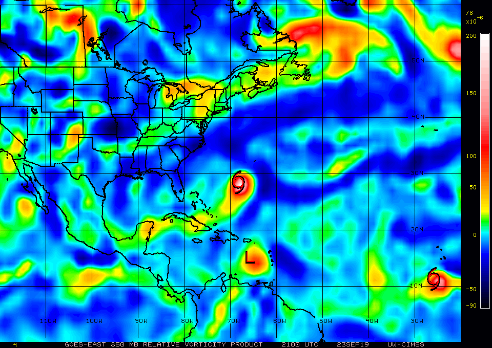
That a vigorous 850mb vortex. Hard to believe she dies. Environment north of PR looks favorable with a huge upper anticyclone. Think the models are going to start ramping her up more in subsequent runs, once Jerry is out of the picture.
0 likes

Re: ATL: KAREN - Tropical Depression - Discussion
gatorcane wrote:That a vigorous 850mb vortex. Hard to believe she dies. Environment north of PR looks favorable with a huge upper anticyclone. Think the models are going to start ramping her up more in subsequent runs, once Jerry is out of the picture.
https://i.postimg.cc/qqJb7V7t/wg8vor.gif
if Jerry ever leaves.
3 likes
-
SFLcane
- S2K Supporter
- Posts: 10281
- Age: 48
- Joined: Sat Jun 05, 2010 1:44 pm
- Location: Lake Worth Florida
Re: ATL: KAREN - Tropical Depression - Discussion
gatorcane wrote:That a vigorous 850mb vortex. Hard to believe she dies. Environment north of PR looks favorable with a huge upper anticyclone. Think the models are going to start ramping her up more in subsequent runs, once Jerry is out of the picture.
https://i.postimg.cc/qqJb7V7t/wg8vor.gif
The 18z Euro shears it to death TC is under northerly shear from the ridge.
0 likes
-
SFLcane
- S2K Supporter
- Posts: 10281
- Age: 48
- Joined: Sat Jun 05, 2010 1:44 pm
- Location: Lake Worth Florida
Re: ATL: KAREN - Tropical Depression - Discussion
Jerry isn't out it's not a favorable pattern if the ULAC is shearing it.
0 likes
Who is online
Users browsing this forum: No registered users and 67 guests