ATL: KAREN - Models
Moderator: S2k Moderators
-
gatorcane

- S2K Supporter

- Posts: 23708
- Age: 48
- Joined: Sun Mar 13, 2005 3:54 pm
- Location: Boca Raton, FL
Re: ATL: KAREN - Models
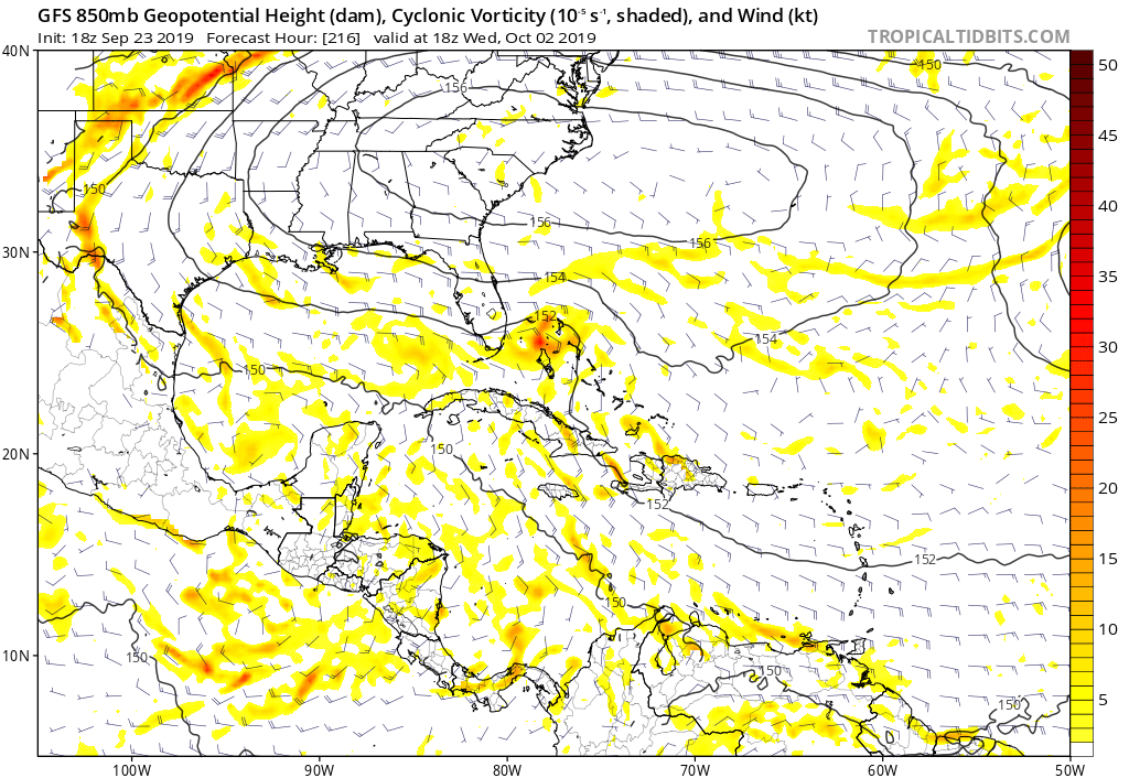
It is interesting to note the GFS spins off another vortex east of Karen’s remnants in the Bahamas then it recurves it along the east coast of Florida. Karen is actually in the SE GOM in that image below. Euro showed something similar but more over South Florida. Considering we are talking 200 hours from now, this could easily be something more significant as we get closer:
Last edited by gatorcane on Mon Sep 23, 2019 7:50 pm, edited 1 time in total.
2 likes
-
Blown Away

- S2K Supporter
- Posts: 10253
- Joined: Wed May 26, 2004 6:17 am
Re: ATL: KAREN - Models
LarryWx wrote:18Z Euro 90 (end of run) similar to 12Z 96
Intensity?
0 likes
Hurricane Eye Experience: David 79, Irene 99, Frances 04, Jeanne 04, Wilma 05… Hurricane Brush Experience: Andrew 92, Erin 95, Floyd 99, Matthew 16, Irma 17, Ian 22, Nicole 22…
Re: ATL: KAREN - Models
Blown Away wrote:LarryWx wrote:18Z Euro 90 (end of run) similar to 12Z 96
Intensity?
Intensity of 18Z Euro 90 similar to that of 12Z 96
0 likes
Personal Forecast Disclaimer:
The posts in this forum are NOT official forecasts and should not be used as such. They are just the opinion of the poster and may or may not be backed by sound meteorological data. They are NOT endorsed by any professional institution or storm2k.org. For official information, please refer to the NHC and NWS products.
The posts in this forum are NOT official forecasts and should not be used as such. They are just the opinion of the poster and may or may not be backed by sound meteorological data. They are NOT endorsed by any professional institution or storm2k.org. For official information, please refer to the NHC and NWS products.
-
Blown Away
- S2K Supporter
- Posts: 10253
- Joined: Wed May 26, 2004 6:17 am
Re: ATL: KAREN - Models
I think this evening almost every model has backed off intensifying Karen... NHC might start their backing out advisories...
2 likes
Hurricane Eye Experience: David 79, Irene 99, Frances 04, Jeanne 04, Wilma 05… Hurricane Brush Experience: Andrew 92, Erin 95, Floyd 99, Matthew 16, Irma 17, Ian 22, Nicole 22…
-
toad strangler

- S2K Supporter
- Posts: 4546
- Joined: Sun Jul 28, 2013 3:09 pm
- Location: Earth
- Contact:
Re: ATL: KAREN - Models
Blown Away wrote:I think this evening almost every model has backed off intensifying Karen... NHC might start their backing out advisories...
Models have never been proficient at intensity forecasts. I seriously doubt the NHC puts more weight on model intensity forecasts than actual meteorology.
6 likes
My Weather Station
https://www.wunderground.com/dashboard/pws/KFLPORTS603
https://www.wunderground.com/dashboard/pws/KFLPORTS603
Re: ATL: KAREN - Models
18Z EPS (goes out to 144) continues the trend to less active and less threatening to the CONUS vs the 12Z EPS, which itself was less active/threatening than the 0Z EPS. To be sure, there are some still well offshore TCs of members at 144 that would probably later threaten the CONUS if the run were to go out a few more days. But I wouldn’t be being honest if I didn’t say that the 18Z 144 is merely a shell of the 0Z 162.
I should also note that the 12Z CDN ensemble is less active/threatening vs the 0Z. Trends, folks. Let’s see what the 0Z consensus suggests.
I should also note that the 12Z CDN ensemble is less active/threatening vs the 0Z. Trends, folks. Let’s see what the 0Z consensus suggests.
2 likes
Personal Forecast Disclaimer:
The posts in this forum are NOT official forecasts and should not be used as such. They are just the opinion of the poster and may or may not be backed by sound meteorological data. They are NOT endorsed by any professional institution or storm2k.org. For official information, please refer to the NHC and NWS products.
The posts in this forum are NOT official forecasts and should not be used as such. They are just the opinion of the poster and may or may not be backed by sound meteorological data. They are NOT endorsed by any professional institution or storm2k.org. For official information, please refer to the NHC and NWS products.
-
gatorcane
- S2K Supporter
- Posts: 23708
- Age: 48
- Joined: Sun Mar 13, 2005 3:54 pm
- Location: Boca Raton, FL
Re: ATL: KAREN - Models
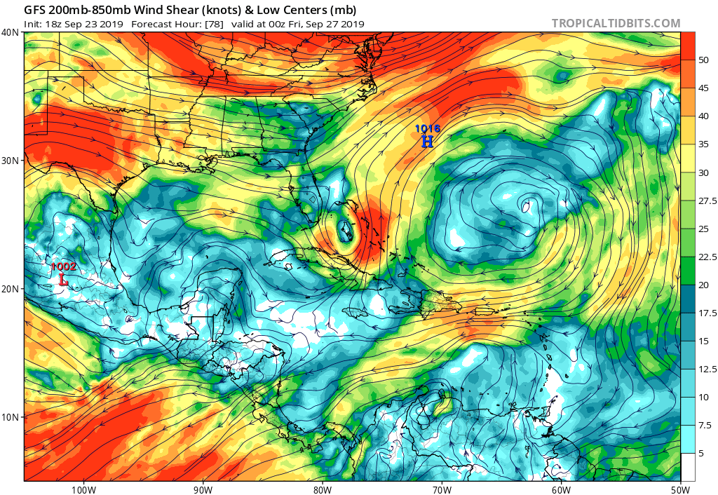
GFS with a very large upper anticyclone NNE of PR for Karen to take advantage of if she remains in tact. Normally this bodes well for intensification, plus the model moves it west in tandem with Karen:
1 likes
-
CreponChris
- Tropical Low

- Posts: 22
- Age: 37
- Joined: Mon Sep 16, 2019 1:27 am
- Contact:
Re: ATL: KAREN - Models
I think this style of track/intensity guidance is helpful because it lets you see the vectors of each ensemble member one time interval at a time. So, not a brand spankin' new model but here's the 12Z EPS for the tropical Atlantic basin  Maybe last post for me tonight, so, if so, have a good one as always.
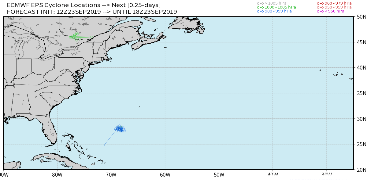
PS: This is all cyclones, I know. Think I'd need to learn Python to give you isolated or individual per-storm animations. And a side note as well for those who don't know, the ECMWF TC data is actually free for active systems in all oceanic basins. The FTP server is ftp://dissemination.ecmwf.int/ Login: wmo pass: essential - the format of the data files is .BUFR - a 1980's-era standard established by some world organization. Recommend BUFRDisplay for Windows (freeware) for the newbie to just look at the raw points plotted out on a map. Take care.
PS: This is all cyclones, I know. Think I'd need to learn Python to give you isolated or individual per-storm animations. And a side note as well for those who don't know, the ECMWF TC data is actually free for active systems in all oceanic basins. The FTP server is ftp://dissemination.ecmwf.int/ Login: wmo pass: essential - the format of the data files is .BUFR - a 1980's-era standard established by some world organization. Recommend BUFRDisplay for Windows (freeware) for the newbie to just look at the raw points plotted out on a map. Take care.
5 likes
-
gatorcane
- S2K Supporter
- Posts: 23708
- Age: 48
- Joined: Sun Mar 13, 2005 3:54 pm
- Location: Boca Raton, FL
Re: ATL: KAREN - Models
I went back and checked the models thread for Dorian. Look around page 9. Euro showed a small 850mb vortex over the Central Bahamas at hour 144.. We know how that ended up. Not saying this is Dorian round 2 but we shouldn’t be fooled by model runs especially this far out.
For your perusing pleasure:
viewtopic.php?f=89&t=120454&hilit=“Dorian+models”&start=160
For your perusing pleasure:
viewtopic.php?f=89&t=120454&hilit=“Dorian+models”&start=160
8 likes
-
TheStormExpert
-
AxaltaRacing24
- Category 5

- Posts: 1774
- Age: 25
- Joined: Wed Jul 27, 2016 11:14 am
- Location: Jupiter, FL
Re: ATL: KAREN - Models
TheStormExpert wrote::uarrow: Conditions are clearly not as favorable as they’re for Dorian.
Dorian looked like it might die and not come back too at some point too though, so let's hope it stays that way for this one.
1 likes
-
gatorcane
- S2K Supporter
- Posts: 23708
- Age: 48
- Joined: Sun Mar 13, 2005 3:54 pm
- Location: Boca Raton, FL
Re: ATL: KAREN - Models
gatorcane wrote:I went back and checked the models thread for Dorian. Look around page 9. Euro showed a small 850mb vortex over the Central Bahamas at hour 144.. We know how that ended up. Not saying this is Dorian round 2 but we shouldn’t be fooled by model runs especially this far out.
For your perusing pleasure:
viewtopic.php?f=89&t=120454&hilit=“Dorian+models”&start=160
For example here is a GFS run for Dorian and we are talking medium range. Shows a wave into the Bahamas at 120-144 hours.

9 likes
-
GeneratorPower

- S2K Supporter
- Posts: 1648
- Age: 46
- Joined: Sun Dec 18, 2005 11:48 pm
- Location: Huntsville, AL
Re: ATL: KAREN - Models
gatorcane wrote:gatorcane wrote:I went back and checked the models thread for Dorian. Look around page 9. Euro showed a small 850mb vortex over the Central Bahamas at hour 144.. We know how that ended up. Not saying this is Dorian round 2 but we shouldn’t be fooled by model runs especially this far out.
For your perusing pleasure:
viewtopic.php?f=89&t=120454&hilit=“Dorian+models”&start=160
For example here is a GFS run for Dorian and we are talking medium range. Shows a wave into the Bahamas at 132-144 hours.
https://i.imgur.com/oCSgoGW.gif
It’s been that kind of season. Really hard to be patient tracking these things with the modeling constantly doing this.
2 likes
-
Blown Away
- S2K Supporter
- Posts: 10253
- Joined: Wed May 26, 2004 6:17 am
Re: ATL: KAREN - Models
gatorcane wrote:gatorcane wrote:I went back and checked the models thread for Dorian. Look around page 9. Euro showed a small 850mb vortex over the Central Bahamas at hour 144.. We know how that ended up. Not saying this is Dorian round 2 but we shouldn’t be fooled by model runs especially this far out.
For your perusing pleasure:
viewtopic.php?f=89&t=120454&hilit=“Dorian+models”&start=160
For example here is a GFS run for Dorian and we are talking medium range. Shows a wave into the Bahamas at 132-144 hours.
https://i.imgur.com/oCSgoGW.gif
I think a track that stays on the left side of the NHC cone, a bit slower, and makes the turn W at/or below @27N and stays at/or West of 65W from now until the turn will find favorable conditions per the earlier model runs... Recent runs want to bend Karen back to @63W and make W turn @28N, those model tracks seem to miss the sweet spot and don't develop... Interesting the NHC pretty divergent from the TVCN with Karen staying at/or W of 65W from now until the W turn @27N and maintaining a strong TS... The 11pm will give clues if they are buying into the latest model trends...
0 likes
Hurricane Eye Experience: David 79, Irene 99, Frances 04, Jeanne 04, Wilma 05… Hurricane Brush Experience: Andrew 92, Erin 95, Floyd 99, Matthew 16, Irma 17, Ian 22, Nicole 22…

Re: ATL: KAREN - Models
Any forecasts by the models for the upper levels past 96-120 hours can be very erroneous, so is way too early to say what kind of UL conditions Karen will have past 5 days if it was to retrograde westward.
I remember also at one point when Dorian was near the Leeward Island the Euro forecasting northerly shear over it as it was to track near the Bahamas, not saying this will be another Dorian but just pointing this out.
I remember also at one point when Dorian was near the Leeward Island the Euro forecasting northerly shear over it as it was to track near the Bahamas, not saying this will be another Dorian but just pointing this out.
0 likes

Re: ATL: KAREN - Models
NDG wrote:Any forecasts by the models for the upper levels past 96-120 hours can be very erroneous, so is way too early to say what kind of UL conditions Karen will have past 5 days if it was to retrograde westward.
I remember also at one point when Dorian was near the Leeward Island the Euro forecasting northerly shear over it as it was to track near the Bahamas, not saying this will be another Dorian but just pointing this out.
Shouldn't this also apply to ridging?
0 likes
Personal Forecast Disclaimer:
The posts in this forum are NOT official forecast and should not be used as such. They are just the opinion of the poster and may or may not be backed by sound meteorological data. They are NOT endorsed by any professional institution or storm2k.org. For official information, please refer to the NHC and NWS products.
The posts in this forum are NOT official forecast and should not be used as such. They are just the opinion of the poster and may or may not be backed by sound meteorological data. They are NOT endorsed by any professional institution or storm2k.org. For official information, please refer to the NHC and NWS products.
Re: ATL: KAREN - Models
SoupBone wrote:NDG wrote:Any forecasts by the models for the upper levels past 96-120 hours can be very erroneous, so is way too early to say what kind of UL conditions Karen will have past 5 days if it was to retrograde westward.
I remember also at one point when Dorian was near the Leeward Island the Euro forecasting northerly shear over it as it was to track near the Bahamas, not saying this will be another Dorian but just pointing this out.
Shouldn't this also apply to ridging?
Mid level ridging? To some degree yes. Models agree that the Bermuda ridge will be building then pushing westward towards the eastern US, how strong and how wide is always going to be challenging past 5 days, it could be stronger or it could be weaker, but definitely not a deep trough pattern coming back to the eastern US at least through the next 7 days.
0 likes
-
Hurricaneman

- Category 5
- Posts: 7404
- Age: 45
- Joined: Tue Aug 31, 2004 3:24 pm
- Location: central florida
-
SouthFLTropics

- Category 5
- Posts: 4258
- Age: 50
- Joined: Thu Aug 14, 2003 8:04 am
- Location: Port St. Lucie, Florida
Re: ATL: KAREN - Models
A very different solution being presented by the 00z GFS...interacts with Jerry and seems to be ready to be carried away to the North Atlantic.
0 likes
Fourth Generation Florida Native
Personal Storm History: David 79, Andrew 92, Erin 95, Floyd 99, Irene 99, Frances 04, Jeanne 04, Wilma 05, Matthew 16, Irma 17, Ian 22, Nicole 22, Milton 24
Personal Storm History: David 79, Andrew 92, Erin 95, Floyd 99, Irene 99, Frances 04, Jeanne 04, Wilma 05, Matthew 16, Irma 17, Ian 22, Nicole 22, Milton 24
-
South Texas Storms

- Professional-Met

- Posts: 4256
- Joined: Thu Jun 24, 2010 12:28 am
- Location: Houston, TX
Re: ATL: KAREN - Models
0z UKMET:
TROPICAL DEPRESSION KAREN ANALYSED POSITION : 15.9N 65.6W
ATCF IDENTIFIER : AL122019
LEAD CENTRAL MAXIMUM WIND
VERIFYING TIME TIME POSITION PRESSURE (MB) SPEED (KNOTS)
-------------- ---- -------- ------------- -------------
0000UTC 24.09.2019 0 15.9N 65.6W 1008 24
1200UTC 24.09.2019 12 17.8N 65.4W 1008 27
0000UTC 25.09.2019 24 20.1N 65.0W 1007 25
1200UTC 25.09.2019 36 22.2N 64.1W 1007 30
0000UTC 26.09.2019 48 24.9N 62.6W 1004 32
1200UTC 26.09.2019 60 27.3N 61.9W 1002 34
0000UTC 27.09.2019 72 29.1N 60.9W 999 46
1200UTC 27.09.2019 84 31.0N 60.7W 1000 40
0000UTC 28.09.2019 96 32.8N 61.9W 1004 33
1200UTC 28.09.2019 108 33.3N 64.4W 1006 28
0000UTC 29.09.2019 120 33.9N 66.5W 1004 35
1200UTC 29.09.2019 132 33.0N 68.0W 1002 31
0000UTC 30.09.2019 144 33.3N 68.7W 999 42
2 likes
Who is online
Users browsing this forum: No registered users and 95 guests