
ATL: KAREN - Remnants - Discussion
Moderator: S2k Moderators
-
Aric Dunn
- Category 5

- Posts: 21238
- Age: 43
- Joined: Sun Sep 19, 2004 9:58 pm
- Location: Ready for the Chase.
- Contact:
Re: ATL: KAREN - Tropical Depression - Discussion
radar and satellite overlay. with both recon fixes circled in white.
3 likes
Note: If I make a post that is brief. Please refer back to previous posts for the analysis or reasoning. I do not re-write/qoute what my initial post said each time.
If there is nothing before... then just ask
Space & Atmospheric Physicist, Embry-Riddle Aeronautical University,
I believe the sky is falling...
If there is nothing before... then just ask
Space & Atmospheric Physicist, Embry-Riddle Aeronautical University,
I believe the sky is falling...
-
SFLcane

- S2K Supporter

- Posts: 10281
- Age: 48
- Joined: Sat Jun 05, 2010 1:44 pm
- Location: Lake Worth Florida
Re: ATL: KAREN - Tropical Depression - Discussion
Aric Dunn wrote:radar and satellite overlay. with both recon fixes circled in white.
https://i.ibb.co/DLdRcNf/Capture.png
Just towers very little organization.
0 likes
-
Blown Away

- S2K Supporter
- Posts: 10253
- Joined: Wed May 26, 2004 6:17 am
Re: ATL: KAREN - Tropical Depression - Discussion
Aric Dunn wrote:radar and satellite overlay. with both recon fixes circled in white.
https://i.ibb.co/DLdRcNf/Capture.png
I assuming any delay will cause Karen to turn W at lower latitude as the HP builds in?
0 likes
Hurricane Eye Experience: David 79, Irene 99, Frances 04, Jeanne 04, Wilma 05… Hurricane Brush Experience: Andrew 92, Erin 95, Floyd 99, Matthew 16, Irma 17, Ian 22, Nicole 22…
-
gatorcane

- S2K Supporter
- Posts: 23708
- Age: 48
- Joined: Sun Mar 13, 2005 3:54 pm
- Location: Boca Raton, FL
Re: ATL: KAREN - Tropical Depression - Discussion
I think the convection burst we are seeing this evening saves Karen...
3 likes
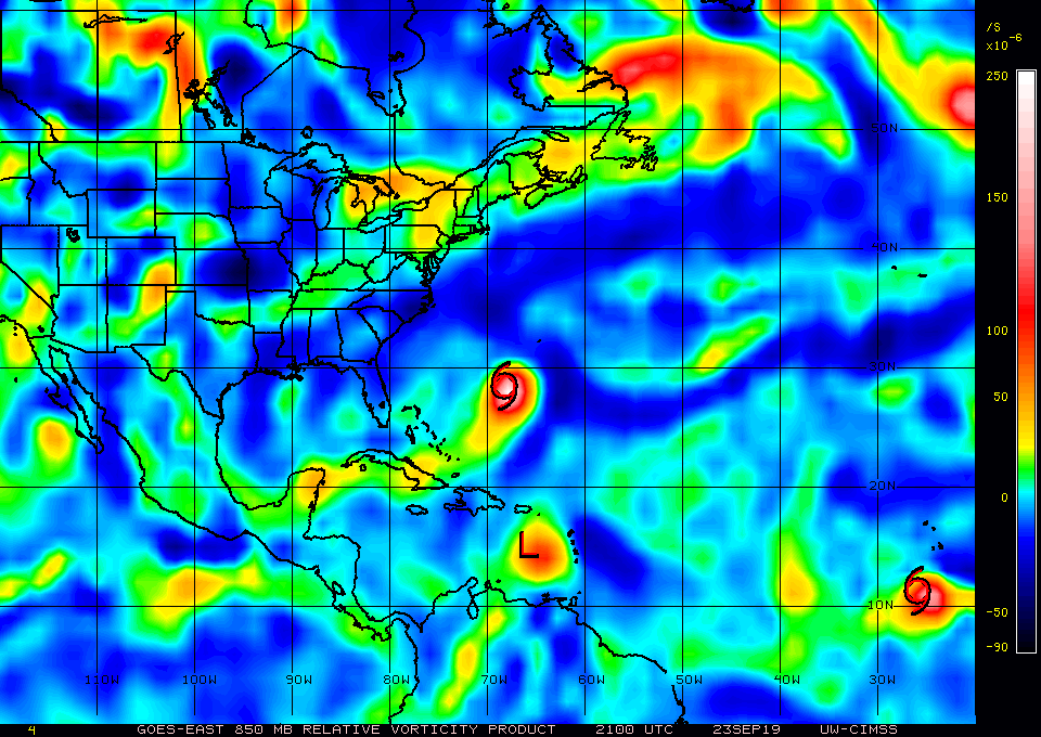
Re: ATL: KAREN - Tropical Depression - Discussion
gatorcane wrote:That a vigorous 850mb vortex. Hard to believe she dies. Environment north of PR looks favorable with a huge upper anticyclone. Think the models are going to start ramping her up more in subsequent runs, once Jerry is out of the picture.
https://i.postimg.cc/qqJb7V7t/wg8vor.gif
That is a huge assumption, and the thing that is getting severely underplayed. Jerry is crawling at a snail's pace, while Karen continues barreling forward. I think the likelihood of them interacting is significant
2 likes
-
Aric Dunn
- Category 5
- Posts: 21238
- Age: 43
- Joined: Sun Sep 19, 2004 9:58 pm
- Location: Ready for the Chase.
- Contact:
Re: ATL: KAREN - Tropical Depression - Discussion
Definitely organizing more with some structured convection. Still sheared of course but holding its own as a TS.
1 likes
Note: If I make a post that is brief. Please refer back to previous posts for the analysis or reasoning. I do not re-write/qoute what my initial post said each time.
If there is nothing before... then just ask
Space & Atmospheric Physicist, Embry-Riddle Aeronautical University,
I believe the sky is falling...
If there is nothing before... then just ask
Space & Atmospheric Physicist, Embry-Riddle Aeronautical University,
I believe the sky is falling...

Re: ATL: KAREN - Tropical Depression - Discussion
sma10 wrote:gatorcane wrote:That a vigorous 850mb vortex. Hard to believe she dies. Environment north of PR looks favorable with a huge upper anticyclone. Think the models are going to start ramping her up more in subsequent runs, once Jerry is out of the picture.
https://i.postimg.cc/qqJb7V7t/wg8vor.gif
That is a huge assumption, and the thing that is getting severely underplayed. Jerry is crawling at a snail's pace, while Karen continues barreling forward. I think the likelihood of them interacting is significant
Jerry is accelerating. The two VDMs were .412 degrees and 99 minutes apart. That's 28.4 miles and works out to 17 mph unless I seriously messed up my math.
6 likes
Kendall -> SLO -> PBC
Memorable Storms: Katrina (for its Florida landfall...) Wilma Matthew Irma
Memorable Storms: Katrina (for its Florida landfall...) Wilma Matthew Irma
-
Blown Away
- S2K Supporter
- Posts: 10253
- Joined: Wed May 26, 2004 6:17 am
Re: ATL: KAREN - Tropical Depression - Discussion

Karen is exploding convection tonight...
7 likes
Hurricane Eye Experience: David 79, Irene 99, Frances 04, Jeanne 04, Wilma 05… Hurricane Brush Experience: Andrew 92, Erin 95, Floyd 99, Matthew 16, Irma 17, Ian 22, Nicole 22…
Re: ATL: KAREN - Tropical Depression - Discussion
Ubuntwo wrote:sma10 wrote:gatorcane wrote:That a vigorous 850mb vortex. Hard to believe she dies. Environment north of PR looks favorable with a huge upper anticyclone. Think the models are going to start ramping her up more in subsequent runs, once Jerry is out of the picture.
https://i.postimg.cc/qqJb7V7t/wg8vor.gif
That is a huge assumption, and the thing that is getting severely underplayed. Jerry is crawling at a snail's pace, while Karen continues barreling forward. I think the likelihood of them interacting is significant
Jerry is accelerating. The two VDMs were .412 degrees and 99 minutes apart. That's 28.4 miles and works out to 17 mph unless I seriously messed up my math.
That is very dubious. Jerry is crawling at 6mph and the NHC suggests this will continue
0 likes
Re: ATL: KAREN - Tropical Depression - Discussion
sma10 wrote:Ubuntwo wrote:sma10 wrote:
That is a huge assumption, and the thing that is getting severely underplayed. Jerry is crawling at a snail's pace, while karen continues barreling forward. I think the likelihood of them interacting is significant
Jerry is accelerating. The two VDMs were .412 degrees and 99 minutes apart. That's 28.4 miles and works out to 17 mph unless I seriously messed up my math.
That is very dubious. Jerry is crawling at 6mph and the NHC suggests this will continue
You can do the math yourself but just look at the recon data. It may have just been a short jog but it did cover nearly half a degree in an hour and a half.
0 likes
Kendall -> SLO -> PBC
Memorable Storms: Katrina (for its Florida landfall...) Wilma Matthew Irma
Memorable Storms: Katrina (for its Florida landfall...) Wilma Matthew Irma
Re: ATL: KAREN - Tropical Depression - Discussion
Ubuntwo wrote:sma10 wrote:Ubuntwo wrote:Jerry is accelerating. The two VDMs were .412 degrees and 99 minutes apart. That's 28.4 miles and works out to 17 mph unless I seriously messed up my math.
That is very dubious. Jerry is crawling at 6mph and the NHC suggests this will continue
You can do the math yourself but just look at the recon data. It may have just been a short jog but it did cover nearly half a degree in an hour and a half.
Apologies, your math is fine. I just find that a sudden acceleration is doubtful. If it continues to move that much over several hours that's another story
0 likes
-
AutoPenalti
- Category 5
- Posts: 4091
- Age: 29
- Joined: Mon Aug 17, 2015 4:16 pm
- Location: Ft. Lauderdale, Florida
Re: ATL: KAREN - Tropical Depression - Discussion
Convection might be shear or DMAX induced.
1 likes
The posts in this forum are NOT official forecasts and should not be used as such. They are just the opinion of the poster and may or may not be backed by sound meteorological data. They are NOT endorsed by any professional institution or STORM2K. For official information, please refer to products from the NHC and NWS.
Model Runs Cheat Sheet:
GFS (5:30 AM/PM, 11:30 AM/PM)
HWRF, GFDL, UKMET, NAVGEM (6:30-8:00 AM/PM, 12:30-2:00 AM/PM)
ECMWF (1:45 AM/PM)
TCVN is a weighted averaged

Re: ATL: KAREN - Tropical Depression - Discussion
One thing the recon has found tonight is a more defined circulation than this morning when it was much broader and they had difficulty centering a COC.
5 likes
-
AJC3

- Admin

- Posts: 4156
- Age: 62
- Joined: Tue Aug 31, 2004 7:04 pm
- Location: Ballston Spa, New York
- Contact:
Re: ATL: KAREN - Tropical Depression - Discussion
As always, a great evening discussion of the tropics from Levi Cowan...
https://www.youtube.com/watch?v=tGdo0x1WGBA
https://www.youtube.com/watch?v=tGdo0x1WGBA
7 likes
-
Blown Away
- S2K Supporter
- Posts: 10253
- Joined: Wed May 26, 2004 6:17 am
Re: ATL: KAREN - Tropical Depression - Discussion
The NHC holds serve keeping Karen a strong TS at day 5 and the west turn... I guess they need a few more model runs to buy into no development after day 4/5...
0 likes
Hurricane Eye Experience: David 79, Irene 99, Frances 04, Jeanne 04, Wilma 05… Hurricane Brush Experience: Andrew 92, Erin 95, Floyd 99, Matthew 16, Irma 17, Ian 22, Nicole 22…
-
toad strangler

- S2K Supporter
- Posts: 4546
- Joined: Sun Jul 28, 2013 3:09 pm
- Location: Earth
- Contact:
Re: ATL: KAREN - Tropical Depression - Discussion
Blown Away wrote:The NHC holds serve keeping Karen a strong TS at day 5 and the west turn... I guess they need a few more model runs to buy into no development after day 4/5...
I guess, but they aren’t model hugging so they are just part of the equation.
2 likes
My Weather Station
https://www.wunderground.com/dashboard/pws/KFLPORTS603
https://www.wunderground.com/dashboard/pws/KFLPORTS603
-
AtlanticWind

- S2K Supporter
- Posts: 1898
- Age: 67
- Joined: Sun Aug 08, 2004 9:57 pm
- Location: Plantation,Fla
Re: ATL: KAREN - Tropical Depression - Discussion
Blown Away wrote:The NHC holds serve keeping Karen a strong TS at day 5 and the west turn... I guess they need a few more model runs to buy into no development after day 4/5...
They are right in line with the intensity models , so I not sure what you mean
0 likes

Re: ATL: KAREN - Tropical Depression - Discussion
Plane finding TS winds out there with low rain rate, which is fairly surprising to say the least.
0 likes
The above post is not official and should not be used as such. It is the opinion of the poster and may or may not be backed by sound meteorological data. It is not endorsed by any professional institution or storm2k.org. For official information, please refer to the NHC and NWS products.
-
AnnularCane

- S2K Supporter
- Posts: 2964
- Joined: Thu Jun 08, 2006 9:18 am
- Location: Wytheville, VA
Re: ATL: KAREN - Tropical Depression - Discussion
Hammy wrote:Plane finding TS winds out there with low rain rate, which is fairly surprising to say the least.
What, the TS winds or the low rain rate?
0 likes
Re: ATL: KAREN - Tropical Depression - Discussion
6.3 magnitude earthquake of the north coast of Puerto Rico late Monday evening. No tsunami expected however. Weird event before Karen passing through tomorrow.
5 likes
Who is online
Users browsing this forum: No registered users and 67 guests