https://twitter.com/yconsor/status/1180037395129016321
2019 Tropics: Global Model Runs Discussion (Out to day 16)
Moderator: S2k Moderators
Forum rules

The posts in this forum are NOT official forecasts and should not be used as such. They are just the opinion of the poster and may or may not be backed by sound meteorological data. They are NOT endorsed by any professional institution or STORM2K. For official information, please refer to products from the National Hurricane Center and National Weather Service.
-
Astromanía
- Category 2

- Posts: 793
- Age: 27
- Joined: Sat Aug 25, 2018 10:34 pm
- Location: Monterrey, N.L, México
Re: 2019 Tropics: Global Model Runs Discussion (Out to day 16)
1 likes
-
bamajammer4eva
- Category 4

- Posts: 907
- Joined: Sun Apr 18, 2010 3:21 am
- Location: Ozark, AL
Re: 2019 Tropics: Global Model Runs Discussion (Out to day 16)
Michael V has spoken... Looks like Atlantic is winding down according to Euro Ens.
https://twitter.com/MJVentrice/status/1180057073167601670
https://twitter.com/MJVentrice/status/1180057073167601670
2 likes
-
jconsor
- Professional-Met

- Posts: 578
- Joined: Mon Jun 30, 2008 9:31 pm
- Location: Jerusalem, Israel
- Contact:
Re: 2019 Tropics: Global Model Runs Discussion (Out to day 16)
Some important context on Michael Ventrice's tweet...
https://twitter.com/yconsor/status/1180067260465065984
https://twitter.com/yconsor/status/1180067260465065984
3 likes
-
gatorcane

- S2K Supporter

- Posts: 23708
- Age: 48
- Joined: Sun Mar 13, 2005 3:54 pm
- Location: Boca Raton, FL
Re: 2019 Tropics: Global Model Runs Discussion (Out to day 16)
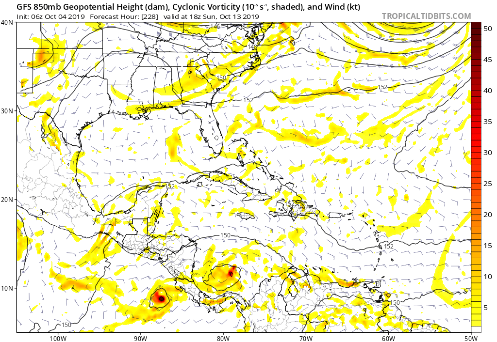
Looks like the last two GFS runs are back to development on the Atlantic side. The timeframe continues to come in so probably no phantom here it looks like. These CAGs (Central America Gyre) give the models fits so no surprise the GFS is struggling with EPAC vs Atlantic. In fact the 06Z has an EPAC and Atlantic side storm out of the gyre. I still think we get a Western Caribbean storm out of this:
5 likes

Re: 2019 Tropics: Global Model Runs Discussion (Out to day 16)
Agree 100% with Yaakov Cantor regarding tropical development in October.
0 likes
blonde stacey (xe/xem/xir)
-
crownweather

- S2K Supporter
- Posts: 602
- Age: 51
- Joined: Sat Aug 12, 2006 9:21 am
- Location: Sturbridge, Massachusetts
- Contact:
Re: 2019 Tropics: Global Model Runs Discussion (Out to day 16)
gatorcane wrote:Looks like the last two GFS runs are back to development on the Atlantic side. The timeframe continues to come in so probably no phantom here it looks like. These CAGs (Central America Gyre) give the models fits so no surprise the GFS is struggling with EPAC vs Atlantic. In fact the 06Z has an EPAC and Atlantic side storm out of the gyre. I still think we get a Western Caribbean storm out of this:
https://i.postimg.cc/T2tKLGGP/gfs-z850-vort-watl-39.png
As Wxman57 mentioned about three pages back, the GFS model has been showing some sort of tropical system to form in the western Caribbean during the 10th-15th time frame since September 27th. So, either the GFS model is consistently right or consistently wrong in its forecast.
I'm with Yaakov & gatorcane on this one & I do think that we'll see something pop between the 10th and 20th in the western Caribbean.
3 likes
Rob Lightbown
Crown Weather Services
https://crownweather.com
Crown Weather Services
https://crownweather.com
Re: 2019 Tropics: Global Model Runs Discussion (Out to day 16)
jconsor wrote:https://twitter.com/yconsor/status/1180095429322653697
Yaakov,
I agree that there’s been a modest increase in W Caribbean activity in the 11-15 day period on the 0Z EPS and one of the things I’ve been talking about is the only limited activity showing on the EPS there in the extended period. However, even with this increase I still count only 4 members out of 51 (8%) with 999 mb or stronger in and near the W Caribbean. In my mind, that’s still only a weak signal. The EPS has had many more than 4 strong members with a scenario that never materialized on a good number of occasions during the last couple of months. Therefore, I’d like to see many more than 4 strong members before getting all that concerned about a potential threat from this area.
Also, I’m still waiting for the GEFS to show a large portion of its members with 999 mb or lower in/near the NW Caribbean earlier than late in week 2 before getting concerned. The latest GEFS (6Z) is still only at 10% of members that strong on day 12 in the W Caribbean although it like many runs over the last week has a lot of activity in the NW Caribbean toward the end of week 2. Since yesterday, I’ve been keying on what the GEFS is showing in the dangerous NW Caribbean as of 0Z on 10/18. This is the benchmark time and location I’m going to focus on now to see whether or not GEFS will finally start to progress earlier in its runs. The 6Z GEFS is fairly active with 15% of members at 999 or lower as of 0Z on 10/18 there, similar to some of yesterday’s runs. Let’s see if 0Z on 10/18 remains pretty active there throughout the weekend GEFS runs and whether or not the weekend EPS runs get much more active than only 4 999 or lower members for then there. Here’s the 6Z GEFS for 0Z on 10/18:

3 likes
Personal Forecast Disclaimer:
The posts in this forum are NOT official forecasts and should not be used as such. They are just the opinion of the poster and may or may not be backed by sound meteorological data. They are NOT endorsed by any professional institution or storm2k.org. For official information, please refer to the NHC and NWS products.
The posts in this forum are NOT official forecasts and should not be used as such. They are just the opinion of the poster and may or may not be backed by sound meteorological data. They are NOT endorsed by any professional institution or storm2k.org. For official information, please refer to the NHC and NWS products.
-
gatorcane
- S2K Supporter
- Posts: 23708
- Age: 48
- Joined: Sun Mar 13, 2005 3:54 pm
- Location: Boca Raton, FL
Re: 2019 Tropics: Global Model Runs Discussion (Out to day 16)
12Z GFS has an EPAC and a Caribbean storm forming out of the CAG. Heading north at 288 hours. Certainly looks possible but liking Caribbean development out of this CAG. The Caribbean storm is much larger. Classic October setup with a weakness to the north over Florida / EGOM / Bahamas.
0 likes
-
WeatherEmperor
- S2K Supporter
- Posts: 4806
- Age: 42
- Joined: Thu Sep 04, 2003 2:54 pm
- Location: South Florida
Re: 2019 Tropics: Global Model Runs Discussion (Out to day 16)
gatorcane wrote:12Z GFS has an EPAC and a Caribbean storm forming out of the CAG. Heading north at 288 hours. Certainly looks possible but liking Caribbean development out of this CAG. The Caribbean storm is much larger. Classic October setup with a weakness to the north over Florida / EGOM / Bahamas.
So far through 216hrs, the Canadian also develops a system in the extreme SW Caribbean and moves it NW but has too much land interaction with Central America to get stronger. So its the GFS and Canadian now showing something forming down there.
0 likes
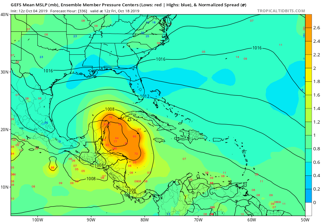
Re: 2019 Tropics: Global Model Runs Discussion (Out to day 16)
Even though it still is late in week 2, the 12Z GEFS is by far the most active in the NW Caribbean of any run so far:
For 0Z on 10/18: Whereas the prior 3 runs had only 3, 6, and 4 members , respectively, with sub 999, this new run has ~12 sub 999 (~60% of members). Whereas the prior 3 runs had only 2, 3, and 2 members , respectively, with sub 991, this new run has ~6 sub 991 (~30%).
**IF this run were real*** it would imply a significant threat to C and S FL as that's where most members then go and that track fits well with climo.
Tidbit maps aren't out yet.
1 likes
Personal Forecast Disclaimer:
The posts in this forum are NOT official forecasts and should not be used as such. They are just the opinion of the poster and may or may not be backed by sound meteorological data. They are NOT endorsed by any professional institution or storm2k.org. For official information, please refer to the NHC and NWS products.
The posts in this forum are NOT official forecasts and should not be used as such. They are just the opinion of the poster and may or may not be backed by sound meteorological data. They are NOT endorsed by any professional institution or storm2k.org. For official information, please refer to the NHC and NWS products.
Re: 2019 Tropics: Global Model Runs Discussion (Out to day 16)
While not a model I find looking at WPC QPF output to be of value and it does depict increasing moisture over the southern Gulf. Peninsular Florida, like much of the southeast, has become very dry lately. A disturbance, depression or tropical storm would likely be a net benefit with needed soaking rains anywhere in the southeast.
https://www.wpc.ncep.noaa.gov/qpf/day1-7.shtml
https://www.wpc.ncep.noaa.gov/qpf/day1-7.shtml
1 likes
-
SFLcane

- S2K Supporter
- Posts: 10281
- Age: 48
- Joined: Sat Jun 05, 2010 1:44 pm
- Location: Lake Worth Florida
Re: 2019 Tropics: Global Model Runs Discussion (Out to day 16)
LarryWx wrote:Even though it still is late in week 2, the 12Z GEFS is by far the most active in the NW Caribbean of any run so far:
For 0Z on 10/18: Whereas the prior 3 runs had only 3, 6, and 4 members , respectively, with sub 999, this new run has ~12 sub 999 (~60% of members). Whereas the prior 3 runs had only 2, 3, and 2 members , respectively, with sub 991, this new run has ~6 sub 991 (~30%).
**IF this run were real*** it would imply a significant threat to C and S FL as that's where most members then go and that track fits well with climo.
Tidbit maps aren't out yet.
Inside 240hrs?
0 likes
Re: 2019 Tropics: Global Model Runs Discussion (Out to day 16)
SFLcane wrote:LarryWx wrote:Even though it still is late in week 2, the 12Z GEFS is by far the most active in the NW Caribbean of any run so far:
For 0Z on 10/18: Whereas the prior 3 runs had only 3, 6, and 4 members , respectively, with sub 999, this new run has ~12 sub 999 (~60% of members). Whereas the prior 3 runs had only 2, 3, and 2 members , respectively, with sub 991, this new run has ~6 sub 991 (~30%).
**IF this run were real*** it would imply a significant threat to C and S FL as that's where most members then go and that track fits well with climo.
Tidbit maps aren't out yet.
Inside 240hrs?
At 240 despite a slightly lower SW Caribbean mean SLP, it is still quiet with only one 1003ish TC in the SW Caribbean and all others weak (1004+) out of 21 members. In order for me to really start believing the GEFS, I'd want to see numerous sub 1004 TCs by hour 240 in the W Caribbean on Sunday's 12Z run. Not waiting for late week 2 but by mid week 2.
0 likes
Personal Forecast Disclaimer:
The posts in this forum are NOT official forecasts and should not be used as such. They are just the opinion of the poster and may or may not be backed by sound meteorological data. They are NOT endorsed by any professional institution or storm2k.org. For official information, please refer to the NHC and NWS products.
The posts in this forum are NOT official forecasts and should not be used as such. They are just the opinion of the poster and may or may not be backed by sound meteorological data. They are NOT endorsed by any professional institution or storm2k.org. For official information, please refer to the NHC and NWS products.
-
gatorcane
- S2K Supporter
- Posts: 23708
- Age: 48
- Joined: Sun Mar 13, 2005 3:54 pm
- Location: Boca Raton, FL
Re: 2019 Tropics: Global Model Runs Discussion (Out to day 16)
LarryWx wrote:Even though it still is late in week 2, the 12Z GEFS is by far the most active in the NW Caribbean of any run so far:
For 0Z on 10/18: Whereas the prior 3 runs had only 3, 6, and 4 members , respectively, with sub 999, this new run has ~12 sub 999 (~60% of members). Whereas the prior 3 runs had only 2, 3, and 2 members , respectively, with sub 991, this new run has ~6 sub 991 (~30%).
**IF this run were real*** it would imply a significant threat to C and S FL as that's where most members then go and that track fits well with climo.
Tidbit maps aren't out yet.
Most active run by far. TT plot below:
1 likes
Re: 2019 Tropics: Global Model Runs Discussion (Out to day 16)
gatorcane wrote:LarryWx wrote:Even though it still is late in week 2, the 12Z GEFS is by far the most active in the NW Caribbean of any run so far:
For 0Z on 10/18: Whereas the prior 3 runs had only 3, 6, and 4 members , respectively, with sub 999, this new run has ~12 sub 999 (~60% of members). Whereas the prior 3 runs had only 2, 3, and 2 members , respectively, with sub 991, this new run has ~6 sub 991 (~30%).
**IF this run were real*** it would imply a significant threat to C and S FL as that's where most members then go and that track fits well with climo.
Tidbit maps aren't out yet.
Most active run by far. TT plot below:
https://i.postimg.cc/FHcqBVqz/gfs-ememb-lowlocs-watl-57.png
Despite this being very active and by far the most active of any GEFS run yet for 10/18, the 0Z EPS despite being a little more active than its prior run still has only 4 sub 999 members then out of 51 and the often overly active GEPS still has almost nothing for then there on its 12Z run.
0 likes
Personal Forecast Disclaimer:
The posts in this forum are NOT official forecasts and should not be used as such. They are just the opinion of the poster and may or may not be backed by sound meteorological data. They are NOT endorsed by any professional institution or storm2k.org. For official information, please refer to the NHC and NWS products.
The posts in this forum are NOT official forecasts and should not be used as such. They are just the opinion of the poster and may or may not be backed by sound meteorological data. They are NOT endorsed by any professional institution or storm2k.org. For official information, please refer to the NHC and NWS products.
-
SFLcane
- S2K Supporter
- Posts: 10281
- Age: 48
- Joined: Sat Jun 05, 2010 1:44 pm
- Location: Lake Worth Florida
Re: 2019 Tropics: Global Model Runs Discussion (Out to day 16)
gatorcane wrote:LarryWx wrote:Even though it still is late in week 2, the 12Z GEFS is by far the most active in the NW Caribbean of any run so far:
For 0Z on 10/18: Whereas the prior 3 runs had only 3, 6, and 4 members , respectively, with sub 999, this new run has ~12 sub 999 (~60% of members). Whereas the prior 3 runs had only 2, 3, and 2 members , respectively, with sub 991, this new run has ~6 sub 991 (~30%).
**IF this run were real*** it would imply a significant threat to C and S FL as that's where most members then go and that track fits well with climo.
Tidbit maps aren't out yet.
Most active run by far. TT plot below:
https://i.postimg.cc/FHcqBVqz/gfs-ememb-lowlocs-watl-57.png
Always two weeks away..
0 likes
Who is online
Users browsing this forum: No registered users and 163 guests