AL, 92, 2019100800, , BEST, 0, 273N, 814W, 20, 1009, DB, 0, , 0, 0, 0, 0, 1010, 100, 30, 0, 0, , 0, , 0, 0, INVEST, ,
AL, 92, 2019100806, , BEST, 0, 281N, 800W, 25, 1009, DB, 0, , 0, 0, 0, 0, 1010, 100, 30, 0, 0, , 0, , 0, 0, INVEST, ,
AL, 92, 2019100812, , BEST, 0, 290N, 780W, 30, 1009, DB, 34, NEQ, 0, 0, 0, 0, 1010, 100, 30, 0, 0, L, 0, , 0, 0, INVEST, M,
Previous thread: viewtopic.php?f=31&t=120648
ATL: INVEST 92L - Discussion
Moderator: S2k Moderators
-
tolakram
- Admin

- Posts: 20189
- Age: 62
- Joined: Sun Aug 27, 2006 8:23 pm
- Location: Florence, KY (name is Mark)
ATL: INVEST 92L - Discussion
0 likes
M a r k
- - - - -
Join us in chat: Storm2K Chatroom Invite. Android and IOS apps also available.
The posts in this forum are NOT official forecasts and should not be used as such. Posts are NOT endorsed by any professional institution or STORM2K.org. For official information and forecasts, please refer to NHC and NWS products.
-
tolakram
- Admin
- Posts: 20189
- Age: 62
- Joined: Sun Aug 27, 2006 8:23 pm
- Location: Florence, KY (name is Mark)
Re: ATL: INVEST 92L - Discussion
SLIDER loops
The edge of this floater: https://rammb-slider.cira.colostate.edu/?sat=goes-16&z=2&im=12&ts=1&st=0&et=0&speed=130&motion=loop&map=1&lat=0&opacity%5B0%5D=1&hidden%5B0%5D=0&pause=0&slider=-1&hide_controls=0&mouse_draw=0&follow_feature=0&follow_hide=0&s=rammb-slider&sec=mesoscale_02&p%5B0%5D=band_02&x=1592.4263916015625&y=423.4449157714844
CONUS: https://rammb-slider.cira.colostate.edu/?sat=goes-16&z=4&im=12&ts=1&st=0&et=0&speed=130&motion=loop&map=1&lat=0&opacity%5B0%5D=1&hidden%5B0%5D=0&pause=0&slider=-1&hide_controls=0&mouse_draw=0&follow_feature=0&follow_hide=0&s=rammb-slider&sec=conus&p%5B0%5D=band_02&x=6801.21875&y=5061.3291015625
0 likes
M a r k
- - - - -
Join us in chat: Storm2K Chatroom Invite. Android and IOS apps also available.
The posts in this forum are NOT official forecasts and should not be used as such. Posts are NOT endorsed by any professional institution or STORM2K.org. For official information and forecasts, please refer to NHC and NWS products.
- - - - -
Join us in chat: Storm2K Chatroom Invite. Android and IOS apps also available.
The posts in this forum are NOT official forecasts and should not be used as such. Posts are NOT endorsed by any professional institution or STORM2K.org. For official information and forecasts, please refer to NHC and NWS products.
-
northjaxpro

- S2K Supporter

- Posts: 8900
- Joined: Mon Sep 27, 2010 11:21 am
- Location: Jacksonville, FL
Re: ATL: INVEST 92L - Discussion
This has a good shot to be a named storm within the next couple of days, possibly even much sooner.
1 likes
NEVER, EVER SAY NEVER in the tropics and weather in general, and most importantly, with life itself!!
________________________________________________________________________________________
Fay 2008 Beryl 2012 Debby 2012 Colin 2016 Hermine 2016 Julia 2016 Matthew 2016 Irma 2017 Dorian 2019
________________________________________________________________________________________
Fay 2008 Beryl 2012 Debby 2012 Colin 2016 Hermine 2016 Julia 2016 Matthew 2016 Irma 2017 Dorian 2019
-
cycloneye

- Admin
- Posts: 149843
- Age: 69
- Joined: Thu Oct 10, 2002 10:54 am
- Location: San Juan, Puerto Rico
Re: ATL: INVEST 92L - Discussion
Recent satellite wind data indicate that a small area of low
pressure has formed in association with an area of disturbed weather
located a few hundred miles southeast of Charleston, South Carolina.
The system is producing winds to near tropical storm strength and
the associated thunderstorm activity has recently shown some signs
of organization. Although upper-level winds, are not particularly
favorable for additional development, only a small increase in
organization could result in the formation of a tropical depression
or storm later today or tonight. On Wednesday, the system is
forecast to merge with the low off the east coast of the United
States, and further development is not anticipated after that time.
* Formation chance through 48 hours...medium...40 percent.
* Formation chance through 5 days...medium...40 percent.
0 likes
Visit the Caribbean-Central America Weather Thread where you can find at first post web cams,radars
and observations from Caribbean basin members Click Here
and observations from Caribbean basin members Click Here
-
EquusStorm
- Category 5

- Posts: 1649
- Age: 35
- Joined: Thu Nov 07, 2013 1:04 pm
- Location: Jasper, AL
- Contact:
Re: ATL: INVEST 92L - Discussion
Not sure how much further increase in organization they're looking for as it looks better than 4-6 of the tropical/subtropical storms we've already had this year
3 likes
Colors of lost purpose on the canvas of irrelevance
Not a meteorologist, in fact more of an idiot than anything. You should probably check with the NHC or a local NWS office for official information.
Not a meteorologist, in fact more of an idiot than anything. You should probably check with the NHC or a local NWS office for official information.
-
Aric Dunn
- Category 5
- Posts: 21238
- Age: 43
- Joined: Sun Sep 19, 2004 9:58 pm
- Location: Ready for the Chase.
- Contact:
Re: ATL: INVEST 92L - Discussion
northjaxpro wrote:This has a good shot to be a named storm within the next couple of days, possibly even much sooner.
Should already be..
I mean the center is exposed now but at least we know its well defined lol.. convection was just over it. Its organized..
No reason not to be classified
2 likes
Note: If I make a post that is brief. Please refer back to previous posts for the analysis or reasoning. I do not re-write/qoute what my initial post said each time.
If there is nothing before... then just ask
Space & Atmospheric Physicist, Embry-Riddle Aeronautical University,
I believe the sky is falling...
If there is nothing before... then just ask
Space & Atmospheric Physicist, Embry-Riddle Aeronautical University,
I believe the sky is falling...
-
northjaxpro
- S2K Supporter
- Posts: 8900
- Joined: Mon Sep 27, 2010 11:21 am
- Location: Jacksonville, FL
Re: ATL: INVEST 92L - Discussion
2 likes
NEVER, EVER SAY NEVER in the tropics and weather in general, and most importantly, with life itself!!
________________________________________________________________________________________
Fay 2008 Beryl 2012 Debby 2012 Colin 2016 Hermine 2016 Julia 2016 Matthew 2016 Irma 2017 Dorian 2019
________________________________________________________________________________________
Fay 2008 Beryl 2012 Debby 2012 Colin 2016 Hermine 2016 Julia 2016 Matthew 2016 Irma 2017 Dorian 2019
-
wxman57

- Moderator-Pro Met

- Posts: 23178
- Age: 68
- Joined: Sat Jun 21, 2003 8:06 pm
- Location: Houston, TX (southwest)
Re: ATL: INVEST 92L - Discussion
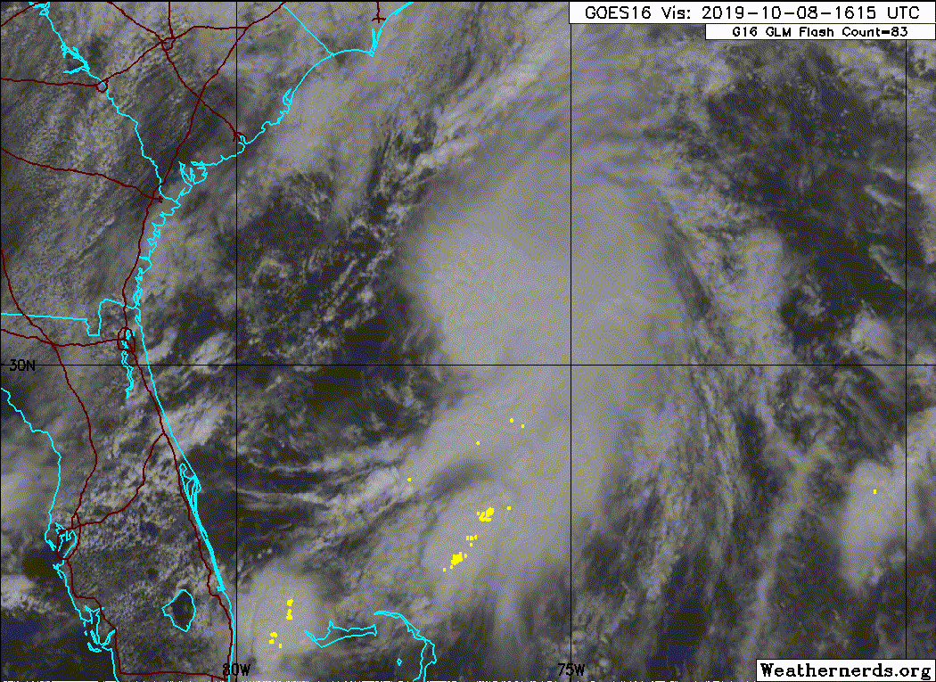
I think it has weakened since earlier this morning. I've indicated where I see the center. The little hook south of my crosshairs is mid to high-level clouds. Low-level winds are out of the SW there. This system will have merged with the front by tomorrow. It's window for being classified as tropical by the NHC is closing fast. The NHC is saying that there's only a 30% chance they'll name the storm system it merges with tomorrow.

1 likes
-
wxman57
- Moderator-Pro Met
- Posts: 23178
- Age: 68
- Joined: Sat Jun 21, 2003 8:06 pm
- Location: Houston, TX (southwest)
Re: ATL: INVEST 92L - Discussion
northjaxpro wrote::uarrow: Yeah ASCAT has verified 35 KT wind. So yeah, they can technically classify it now. I agree. This may be one of these special advisory or update situations here for NHC in this case. We will see.
Brown (NHC) only went 40% with the PM outlook, which indicates that the NHC is going to just let it do unclassified since it won't be around by tomorrow morning (separate from the cold front).
1 likes
-
northjaxpro
- S2K Supporter
- Posts: 8900
- Joined: Mon Sep 27, 2010 11:21 am
- Location: Jacksonville, FL
Re: ATL: INVEST 92L - Discussion
Good point 57. I was thinking about the merge with the front a few minutes ago before my last post. Yeah, Invest 92L may have missed its opportunity to be classified on its own, at least as a TD, although I still think this will and should be discussed in post analysis
Last edited by northjaxpro on Tue Oct 08, 2019 1:15 pm, edited 1 time in total.
2 likes
NEVER, EVER SAY NEVER in the tropics and weather in general, and most importantly, with life itself!!
________________________________________________________________________________________
Fay 2008 Beryl 2012 Debby 2012 Colin 2016 Hermine 2016 Julia 2016 Matthew 2016 Irma 2017 Dorian 2019
________________________________________________________________________________________
Fay 2008 Beryl 2012 Debby 2012 Colin 2016 Hermine 2016 Julia 2016 Matthew 2016 Irma 2017 Dorian 2019
-
EquusStorm
- Category 5
- Posts: 1649
- Age: 35
- Joined: Thu Nov 07, 2013 1:04 pm
- Location: Jasper, AL
- Contact:
Re: ATL: INVEST 92L - Discussion
Standards for tropical cyclone classification seem dramatically stricter than for subtropical cyclones lately. Don't understand it but eh, not my call.
0 likes
Colors of lost purpose on the canvas of irrelevance
Not a meteorologist, in fact more of an idiot than anything. You should probably check with the NHC or a local NWS office for official information.
Not a meteorologist, in fact more of an idiot than anything. You should probably check with the NHC or a local NWS office for official information.
-
Aric Dunn
- Category 5
- Posts: 21238
- Age: 43
- Joined: Sun Sep 19, 2004 9:58 pm
- Location: Ready for the Chase.
- Contact:
Re: ATL: INVEST 92L - Discussion
They may end up doing this one in post season. Its pretty clear it was a tc late last night and of course now.
Interesting to see how this system evolves.. models... none (up until recent runs) showed this much development.
Interesting to see how this system evolves.. models... none (up until recent runs) showed this much development.
1 likes
Note: If I make a post that is brief. Please refer back to previous posts for the analysis or reasoning. I do not re-write/qoute what my initial post said each time.
If there is nothing before... then just ask
Space & Atmospheric Physicist, Embry-Riddle Aeronautical University,
I believe the sky is falling...
If there is nothing before... then just ask
Space & Atmospheric Physicist, Embry-Riddle Aeronautical University,
I believe the sky is falling...
-
CyclonicFury

- Category 5
- Posts: 2040
- Age: 27
- Joined: Sun Jul 02, 2017 12:32 pm
- Location: NC
- Contact:
Re: ATL: INVEST 92L - Discussion
wxman57 wrote:northjaxpro wrote::uarrow: Yeah ASCAT has verified 35 KT wind. So yeah, they can technically classify it now. I agree. This may be one of these special advisory or update situations here for NHC in this case. We will see.
Brown (NHC) only went 40% with the PM outlook, which indicates that the NHC is going to just let it do unclassified since it won't be around by tomorrow morning (separate from the cold front).
I still think it's possible they may classify it. If they were certain about not classifying it they would not have raised chances by 30%. NHC classified TD 3 in a similar borderline case earlier this year.
0 likes
NCSU B.S. in Meteorology Class of 2021. Tropical weather blogger at http://www.cyclonicfury.com. My forecasts and thoughts are NOT official, for official forecasts please consult the National Hurricane Center.
-
EquusStorm
- Category 5
- Posts: 1649
- Age: 35
- Joined: Thu Nov 07, 2013 1:04 pm
- Location: Jasper, AL
- Contact:
Re: ATL: INVEST 92L - Discussion
They waited till near dissipation to classify that depression last year too so if it doesn't degrade more I won't count it out, but they've likely missed the strongest point.
Though... they also ignored this last year so...
Though... they also ignored this last year so...
0 likes
Colors of lost purpose on the canvas of irrelevance
Not a meteorologist, in fact more of an idiot than anything. You should probably check with the NHC or a local NWS office for official information.
Not a meteorologist, in fact more of an idiot than anything. You should probably check with the NHC or a local NWS office for official information.
-
wxman57
- Moderator-Pro Met
- Posts: 23178
- Age: 68
- Joined: Sat Jun 21, 2003 8:06 pm
- Location: Houston, TX (southwest)
Re: ATL: INVEST 92L - Discussion
92L is currently being sheared apart this afternoon. It will merge with the front by tomorrow morning and be part of a significant storm system east of New Jersey by Thursday morning. Here's a plot of the latest Euro with wind contours in mph. That light blue is 55+ mph. Tides 2-3 feet above normal along the coast Wed-Fri. TS winds Cape Cod to New Jersey coast.


2 likes

Re: ATL: INVEST 92L - Discussion
Moving NE with the front after drifting around out there for days. Just add it to Karens numbers.
0 likes
-
Sciencerocks
- Category 5
- Posts: 10194
- Age: 40
- Joined: Thu Jul 06, 2017 1:51 am
-
johngaltfla

- Category 5
- Posts: 2074
- Joined: Sun Jul 10, 2005 9:17 pm
- Location: Sarasota County, FL
- Contact:
Re: ATL: INVEST 92L - Discussion
Nice swirl. If it had time over the Gulf Stream plus more favorable upper level winds, Sandy Jr. would be born.
0 likes
-
wxman57
- Moderator-Pro Met
- Posts: 23178
- Age: 68
- Joined: Sat Jun 21, 2003 8:06 pm
- Location: Houston, TX (southwest)
Re: ATL: INVEST 92L - Discussion
Looks like it's just about gone this evening. It'll become part of the big east coast low tomorrow.
2 likes
-
USTropics
- Professional-Met

- Posts: 2742
- Joined: Sun Aug 12, 2007 3:45 am
- Location: Florida State University
Re: ATL: INVEST 92L - Discussion
Most model guidance has invest 92L and invest 91L being absorbed by the low-pressure area developing off the mid-Atlantic coast (talk about a black hole effect  ). System should stall for a few days thanks to a blocking high over Newfoundland before slowly dissipating/moving off to the NE:

3 likes
Who is online
Users browsing this forum: No registered users and 35 guests