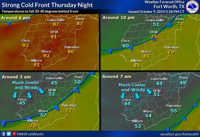
NWS FTW bumped up todays high to 88, and Thursday 92 as the resultant warm advection will mean a warmer and more humid day as temperatures bounce back above normal while dewpoints climb into the 60s.
Texas Fall 2019
Moderator: S2k Moderators
Forum rules

The posts in this forum are NOT official forecast and should not be used as such. They are just the opinion of the poster and may or may not be backed by sound meteorological data. They are NOT endorsed by any professional institution or STORM2K.
-
CaptinCrunch

- S2K Supporter

- Posts: 8747
- Age: 57
- Joined: Mon Nov 03, 2003 4:33 pm
- Location: Kennedale, TX (Tarrant Co.)
Re: Texas Fall 2019
Yesterday's high of 79 @ DFW was the first 70 degree day since June 11th (78F)
NWS FTW bumped up todays high to 88, and Thursday 92 as the resultant warm advection will mean a warmer and more humid day as temperatures bounce back above normal while dewpoints climb into the 60s.
NWS FTW bumped up todays high to 88, and Thursday 92 as the resultant warm advection will mean a warmer and more humid day as temperatures bounce back above normal while dewpoints climb into the 60s.
1 likes
-
CaptinCrunch
- S2K Supporter
- Posts: 8747
- Age: 57
- Joined: Mon Nov 03, 2003 4:33 pm
- Location: Kennedale, TX (Tarrant Co.)
Re: Texas Fall 2019

This is the 1st major Winter event of the season for the U.S. and it stretches all the way up into Alaska. Hopefully a sign of things to come this Winter!

A significant cold front will move across the area on Thursday, with arctic air coming in behind a low through the day and into the night. Temperatures will fall below freezing across most of the area overnight Thursday,
with some snow flurries flying as well. The major concern will be wind chill temperatures dropping as low as 5 degrees as northwest winds around 25 to 35 MPH affect the region.

2 likes
-
weatherdude1108
- Category 5

- Posts: 4228
- Joined: Tue Dec 13, 2011 1:04 pm
- Location: Northwest Austin/Cedar Park, TX
Re: Texas Fall 2019
CaptinCrunch wrote:https://forecast.weather.gov/wwamap/png/US.png
This is the 1st major Winter event of the season for the U.S. and it stretches all the way up into Alaska. Hopefully a sign of things to come this Winter!
http://www.weather.gov/images/ama/graphicast/image5.png?a23f448c96cf45c8b5610425e93b2fb5
A significant cold front will move across the area on Thursday, with arctic air coming in behind a low through the day and into the night. Temperatures will fall below freezing across most of the area overnight Thursday,
with some snow flurries flying as well. The major concern will be wind chill temperatures dropping as low as 5 degrees as northwest winds around 25 to 35 MPH affect the region.
http://www.weather.gov/images/ama/graphicast/image2.png?a23f448c96cf45c8b5610425e93b2fb5
I know Lubbock typically gets their first freeze in early October, at least going by past climate history. Anything goes now with the current climate.
1 likes
The preceding post is NOT an official forecast, and should not be used as such. It is only the opinion of the poster and may or may not be backed by sound meteorological data. It is NOT endorsed by any professional institution including storm2k.org. For Official Information please refer to the NHC and NWS products.

Re: Texas Fall 2019
The 12Z NAM has a brutal drop in temps for DFW -44 degrees. 
Thu 6PM - 87 degrees
Fri 6AM - 43 degrees
Thu 6PM - 87 degrees
Fri 6AM - 43 degrees
3 likes
The above post and any post by dhweather is NOT an official forecast and should not be used as such. It is just the opinion of the poster and may or may not be backed by sound meteorological data. It is NOT endorsed by any professional institution including storm2k.org. For official information, please refer to NWS products.
Re: Texas Fall 2019
My bones already hurt just watching this.

1 likes
The above post and any post by dhweather is NOT an official forecast and should not be used as such. It is just the opinion of the poster and may or may not be backed by sound meteorological data. It is NOT endorsed by any professional institution including storm2k.org. For official information, please refer to NWS products.
-
CaptinCrunch
- S2K Supporter
- Posts: 8747
- Age: 57
- Joined: Mon Nov 03, 2003 4:33 pm
- Location: Kennedale, TX (Tarrant Co.)
Re: Texas Fall 2019
weatherdude1108 wrote:CaptinCrunch wrote:https://forecast.weather.gov/wwamap/png/US.png
This is the 1st major Winter event of the season for the U.S. and it stretches all the way up into Alaska. Hopefully a sign of things to come this Winter!
http://www.weather.gov/images/ama/graphicast/image5.png?a23f448c96cf45c8b5610425e93b2fb5
A significant cold front will move across the area on Thursday, with arctic air coming in behind a low through the day and into the night. Temperatures will fall below freezing across most of the area overnight Thursday,
with some snow flurries flying as well. The major concern will be wind chill temperatures dropping as low as 5 degrees as northwest winds around 25 to 35 MPH affect the region.
http://www.weather.gov/images/ama/graphicast/image2.png?a23f448c96cf45c8b5610425e93b2fb5
I know Lubbock typically gets their first freeze in early October, at least going by past climate history. Anything goes now with the current climate.
Lubbock has a freeze watch issued for early Friday morning, Lubbock's forecast high today is 88F, Friday's it's 55F
1 likes
-
bubba hotep

- S2K Supporter
- Posts: 5850
- Joined: Wed Dec 28, 2016 1:00 am
- Location: Collin County Texas

-
rwfromkansas
- Category 5
- Posts: 2766
- Joined: Sat Aug 27, 2005 12:47 am
- Location: North Fort Worth
Re: Texas Fall 2019
Looks like some places up north are skipping a regular freeze and going right into a very hard freeze (low 20s) Friday morning. Not sure if that has any implications for us down the road, but interesting.
1 likes
-
bubba hotep
- S2K Supporter
- Posts: 5850
- Joined: Wed Dec 28, 2016 1:00 am
- Location: Collin County Texas
Re: Texas Fall 2019
Model ares trending pretty wet for DFW, maybe the 40 day rainless streak is finally broken and with a bang?
1 likes
Winter time post are almost exclusively focused on the DFW area.
-
weatherdude1108
- Category 5
- Posts: 4228
- Joined: Tue Dec 13, 2011 1:04 pm
- Location: Northwest Austin/Cedar Park, TX
Re: Texas Fall 2019
Today's 12 GFS shows some anomalous precip. rates from Sunday the 20th through Tuesday the 22nd, along with around 12" of QPF in the Austin metro (total from now through the end of the run).  That would be a drought buster!
Is it picking up on recurving Pacific storms?


Is it picking up on recurving Pacific storms?
1 likes
The preceding post is NOT an official forecast, and should not be used as such. It is only the opinion of the poster and may or may not be backed by sound meteorological data. It is NOT endorsed by any professional institution including storm2k.org. For Official Information please refer to the NHC and NWS products.
-
weatherdude1108
- Category 5
- Posts: 4228
- Joined: Tue Dec 13, 2011 1:04 pm
- Location: Northwest Austin/Cedar Park, TX
Re: Texas Fall 2019


2 likes
The preceding post is NOT an official forecast, and should not be used as such. It is only the opinion of the poster and may or may not be backed by sound meteorological data. It is NOT endorsed by any professional institution including storm2k.org. For Official Information please refer to the NHC and NWS products.
-
weatherdude1108
- Category 5
- Posts: 4228
- Joined: Tue Dec 13, 2011 1:04 pm
- Location: Northwest Austin/Cedar Park, TX
Re: Texas Fall 2019
EWX discussion. Maybe we'll get into a regular wet and cool Fall pattern(?).
912
FXUS64 KEWX 092011
AFDEWX
Area Forecast Discussion
National Weather Service Austin/San Antonio TX
311 PM CDT Wed Oct 9 2019
.SHORT TERM (Tonight through Thursday Night)...
Near record heat and an influx of moisture is forming some streamer
showers down around Victoria and Goliad, but minimal activity is
expected to move into South Central TX counties with most of it
expected to dissipate by around 00Z. Humid and breezy conditions will
continue ahead of the next approaching cold front with the associated
upper trough base expected to clip NW TX before lifting NE Friday.
With most areas still expected to be south of the front through 09Z,
and no convection expected before the front, will save discussion of
the front and its following impacts for the long term section.
Below is a recap of the temps and records for today/Thursday:
Forecast / Record / Forecast / Record
High High High High
10/09 10/09 10/10 10/10
Austin Mabry....... 93 / 95 (1926) / 96 / 97 (1926)
Austin Bergstrom... 92 / 93 (1956) / 95 / 93 (2014)
San Antonio........ 92 / 94 (2014) / 94 / 98 (1894)
Del Rio............ 95 / 95 (1956) / 99 / 97 (1922)
&&
.LONG TERM (Friday through Wednesday)...
Friday morning lows will show a north to south gradient which could
be prone to shifting if the timing of the front changes. Run to run
trends among the deterministic models show pretty good consistency
with the front remaining north of Hwy 90 through 09Z and south of the
forecast area by 15Z. The cool air could be accompanied by occasional
showers which could add to the chilly conditions for those outdoors
and not expecting the front through midday Friday. Rain chances
should decrease from N to S Friday afternoon, but some lingering
elevated light showers could stream across southern counties through
Friday night. Mid level clouds are expected to continue streaming
over Texas as the flattened westerly flow pattern aloft picks up
Pacific moisture from a developing region of instability. Little
rainfall is expected this weekend, but the clouds would keep post-
frontal diurnal temperature ranges dampened.
By Monday morning, southerly flow returns, and most model data and
the NHC expect to see an eastern Pacific cyclone moving generally
toward Baja Ca. A steady fetch of this mid-level moisture should
combine with low level, or Gulf moisture return to increase rain
chances as early as Monday over the Coastal Prairies. The coverage
should be more broad over South Central Texas for Tuesday into
Wednesday. With the cyclone not having formed yet, will cap pops to
below 40 percent. The best rain chances should ultimately arrive
when another polar front arrives sometime Tuesday night or Wednesday,
but poor timing agreement among the deterministic models warrant a
wider window for the chances and reduced overall chances.
2 likes
The preceding post is NOT an official forecast, and should not be used as such. It is only the opinion of the poster and may or may not be backed by sound meteorological data. It is NOT endorsed by any professional institution including storm2k.org. For Official Information please refer to the NHC and NWS products.
-
Portastorm

- Storm2k Moderator

- Posts: 9914
- Age: 63
- Joined: Fri Jul 11, 2003 9:16 am
- Location: Round Rock, TX
- Contact:
Re: Texas Fall 2019
I was telling Haris today that I don't think we (Austin) will get out of the 50s after the front passes and temperatures drop into the 50s. The short-range meso models like the NAM and the Tech WRF are going in that direction. Globals like the Euro look a little warmer.
And yeah weatherdude, I'm hopeful about next week and beyond. We surely need rain and plenty of it.
4 likes
Any forecasts under my name are to be taken with a grain of salt. Get your best forecasts from the National Weather Service and National Hurricane Center.
-
weatherdude1108
- Category 5
- Posts: 4228
- Joined: Tue Dec 13, 2011 1:04 pm
- Location: Northwest Austin/Cedar Park, TX
Re: Texas Fall 2019
Portastorm wrote::uarrow:
I was telling Haris today that I don't think we (Austin) will get out of the 50s after the front passes and temperatures drop into the 50s. The short-range meso models like the NAM and the Tech WRF are going in that direction. Globals like the Euro look a little warmer.
And yeah weatherdude, I'm hopeful about next week and beyond. We surely need rain and plenty of it.
I noticed that on the GFS, and just now on the Mesoscale NAM and TTUWRF (don't have access to euro since I'm not paying) that highs don't get out of the 50s! Crazy after the last several months we've had around here, but I'll gladly take it, and a lot of water!
2 likes
The preceding post is NOT an official forecast, and should not be used as such. It is only the opinion of the poster and may or may not be backed by sound meteorological data. It is NOT endorsed by any professional institution including storm2k.org. For Official Information please refer to the NHC and NWS products.
-
bubba hotep
- S2K Supporter
- Posts: 5850
- Joined: Wed Dec 28, 2016 1:00 am
- Location: Collin County Texas
-
starsfan65

- Category 2

- Posts: 731
- Age: 48
- Joined: Thu Dec 17, 2015 1:18 pm
- Location: Garland,Tx
Re: Texas Fall 2019
bubba hotep wrote:https://pbs.twimg.com/media/EGeYe81UEAAs0N6?format=jpg&name=small
I think 51 degrees is too modest.
1 likes
-
jasons2k

- Storm2k Executive

- Posts: 8251
- Age: 52
- Joined: Wed Jul 06, 2005 12:32 pm
- Location: The Woodlands, TX
Re: Texas Fall 2019
Looking forward to Friday’s front. It’s already humid again down here. Hopefully we get some rain too as we have already dried out after Imelda.
1 likes
-
starsfan65
- Category 2
- Posts: 731
- Age: 48
- Joined: Thu Dec 17, 2015 1:18 pm
- Location: Garland,Tx
-
CaptinCrunch
- S2K Supporter
- Posts: 8747
- Age: 57
- Joined: Mon Nov 03, 2003 4:33 pm
- Location: Kennedale, TX (Tarrant Co.)
Re: Texas Fall 2019
starsfan65 wrote:bubba hotep wrote:https://pbs.twimg.com/media/EGeYe81UEAAs0N6?format=jpg&name=small
I think 51 degrees is too modest.
I think tomorrow's forecast is going to go a few degrees colder for Friday, I would say lower 50's for a high rather than upper 50's, add in wet weather and it will feel every bit of early Winter.
1 likes
-
South Texas Storms

- Professional-Met

- Posts: 4246
- Joined: Thu Jun 24, 2010 12:28 am
- Location: Houston, TX
Re: Texas Fall 2019
starsfan65 wrote:When is the 0z NAM run start?
It starts running around 8:45 am/pm. The 0z run just finished.
0 likes
Return to “USA & Caribbean Weather”
Who is online
Users browsing this forum: No registered users and 110 guests