ATL: NESTOR - Models
Moderator: S2k Moderators
-
cycloneye

- Admin

- Posts: 149214
- Age: 69
- Joined: Thu Oct 10, 2002 10:54 am
- Location: San Juan, Puerto Rico
ATL: NESTOR - Models
Only model runs here.
0 likes
Visit the Caribbean-Central America Weather Thread where you can find at first post web cams,radars
and observations from Caribbean basin members Click Here
and observations from Caribbean basin members Click Here

ATL: INVEST 96L - Discussion
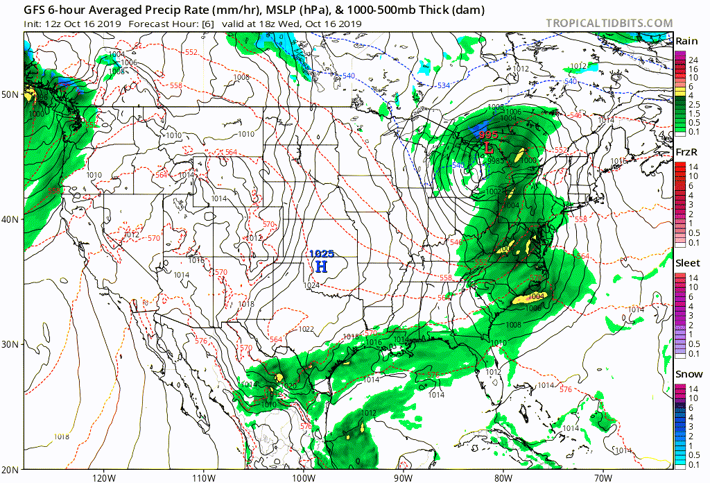
Looks like landfall extreme western panhandle of FL for 12z Euro if I extrapolate it between 24 hour points. Euro does not appear to strengthen it like other models but I have the low resolution version.
https://www.tropicaltidbits.com/analysis/models/?model=ecmwf®ion=us&pkg=mslp_uv850&runtime=2019101612&fh=72
Correction: its Mobile Bay landfall at 998 mb - 6 pm Saturday so its slower than other models.
https://www.tropicaltidbits.com/analysis/models/?model=ecmwf®ion=us&pkg=mslp_uv850&runtime=2019101612&fh=72
Correction: its Mobile Bay landfall at 998 mb - 6 pm Saturday so its slower than other models.
0 likes

Re: ATL: INVEST 96L - Models
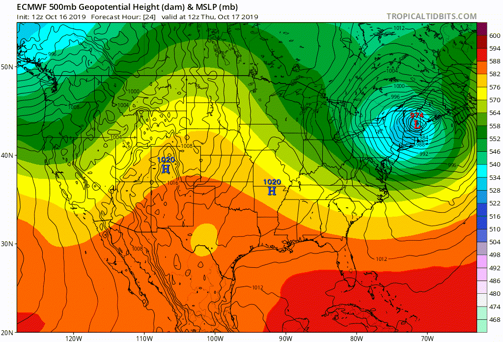
Just saw both the 12Z Euro as well as the new NHC 2:00pm TWO. Euro seems very much in line with the other Globals and suggests that 96L will develop as a direct result of it's interaction with, and eventual co-alignment with the separate mid level low forecast to develop over Texas and moving eastward from there. I do not see any model support for development that suggests 96L develops and moves on a further south track which the latest NHC TWO suggests, which appears to bring the system further east of Apalachicola perhaps closer to Ceder Key. This leads me to believe that "Nestor" will in fact develop quite near the N. Gulf coast while merging with this mid level 500mb feature in the process.... and NOT as an independent tropical low that by itself might trek further east under somewhat hostile upper level conditions and less likely to maintain it's own coherent vertical structure.
I think that if 96L were delayed in developing and remained stationary long enough to miss merging with the newly developing Texas low somewhere along the N. Gulf coast, that all models would then immediately back off developing it.
I think that if 96L were delayed in developing and remained stationary long enough to miss merging with the newly developing Texas low somewhere along the N. Gulf coast, that all models would then immediately back off developing it.
0 likes
Andy D
(For official information, please refer to the NHC and NWS products.)
(For official information, please refer to the NHC and NWS products.)
-
Sciencerocks
- Category 5

- Posts: 10181
- Age: 40
- Joined: Thu Jul 06, 2017 1:51 am
-
Sciencerocks
- Category 5
- Posts: 10181
- Age: 40
- Joined: Thu Jul 06, 2017 1:51 am

Re: ATL: INVEST 96L - Models
12Z UKMET and 121Z GFS are pushing this more to the warm-core side than previous runs.
0 likes
-
Dylan

- Professional-Met

- Posts: 338
- Age: 31
- Joined: Mon May 31, 2010 9:50 am
- Location: New Orleans, LA
Re: ATL: INVEST 96L - Models
0 likes
Georges('98), Allison('01), Isidore('02), Lili('02), Frances('04) Ivan('04), Cindy('05), Katrina('05), Rita('05), Gustav('08), Isaac('12), Matthew('16), Harvey('17), Irma('17), Nate ('17), Ida ('21).
Re: ATL: INVEST 96L - Models
Early guidance suggests Apalachicola FL. (Cape San Blas)
https://www.sfwmd.gov/weather-radar/hurricane-model-plots
https://www.sfwmd.gov/weather-radar/hurricane-model-plots
0 likes
-
Aric Dunn
- Category 5
- Posts: 21238
- Age: 43
- Joined: Sun Sep 19, 2004 9:58 pm
- Location: Ready for the Chase.
- Contact:
ATL: INVEST 96L - Discussion
Gfs is doing better with the intitial conditions and organizing the southern circ that is there. After 48 hours it re develops circ way way to the ne..
0 likes
Note: If I make a post that is brief. Please refer back to previous posts for the analysis or reasoning. I do not re-write/qoute what my initial post said each time.
If there is nothing before... then just ask
Space & Atmospheric Physicist, Embry-Riddle Aeronautical University,
I believe the sky is falling...
If there is nothing before... then just ask
Space & Atmospheric Physicist, Embry-Riddle Aeronautical University,
I believe the sky is falling...
-
Dean4Storms
- S2K Supporter

- Posts: 6358
- Age: 63
- Joined: Sun Aug 31, 2003 1:01 pm
- Location: Miramar Bch. FL
Re: ATL: INVEST 96L - Models
ronjon wrote:Early guidance suggests Apalachicola FL. (Cape San Blas)
https://www.sfwmd.gov/weather-radar/hurricane-model-plots
Just don't see it going that far east.
0 likes
-
northjaxpro

- S2K Supporter
- Posts: 8900
- Joined: Mon Sep 27, 2010 11:21 am
- Location: Jacksonville, FL
Re: ATL: INVEST 96L - Models
Remember, it will be quite probable the system will be sheared, with the heaviest rain removed northeast and east of that CoC.
Last edited by northjaxpro on Wed Oct 16, 2019 6:15 pm, edited 1 time in total.
0 likes
NEVER, EVER SAY NEVER in the tropics and weather in general, and most importantly, with life itself!!
________________________________________________________________________________________
Fay 2008 Beryl 2012 Debby 2012 Colin 2016 Hermine 2016 Julia 2016 Matthew 2016 Irma 2017 Dorian 2019
________________________________________________________________________________________
Fay 2008 Beryl 2012 Debby 2012 Colin 2016 Hermine 2016 Julia 2016 Matthew 2016 Irma 2017 Dorian 2019
Re: ATL: INVEST 96L - Models
18z HWRF at 981 mb about 100 miles south of Mobile at 51 hrs.
https://www.tropicaltidbits.com/analysis/models/?model=hwrf®ion=96L&pkg=ref&runtime=2019101618&fh=51
https://www.tropicaltidbits.com/analysis/models/?model=hwrf®ion=96L&pkg=ref&runtime=2019101618&fh=51
0 likes
-
Dean4Storms
- S2K Supporter
- Posts: 6358
- Age: 63
- Joined: Sun Aug 31, 2003 1:01 pm
- Location: Miramar Bch. FL
Re: ATL: INVEST 96L - Models
northjaxpro wrote::uarrow: Well, the latest 18Z GFS has the cyclone pushing inland Florida Big Bend around Saint Marks, which is just south of Tallahassee on 12Z Saturday morning at 1001 mb.
Yea, thinks it's a bit too fast.
0 likes
-
northjaxpro
- S2K Supporter
- Posts: 8900
- Joined: Mon Sep 27, 2010 11:21 am
- Location: Jacksonville, FL
Re: ATL: INVEST 96L - Models
Dean4Storms wrote:northjaxpro wrote::uarrow: Well, the latest 18Z GFS has the cyclone pushing inland Florida Big Bend around Saint Marks, which is just south of Tallahassee on 12Z Saturday morning at 1001 mb.
Yea, thinks it's a bit too fast.
We will see Dean.
0 likes
NEVER, EVER SAY NEVER in the tropics and weather in general, and most importantly, with life itself!!
________________________________________________________________________________________
Fay 2008 Beryl 2012 Debby 2012 Colin 2016 Hermine 2016 Julia 2016 Matthew 2016 Irma 2017 Dorian 2019
________________________________________________________________________________________
Fay 2008 Beryl 2012 Debby 2012 Colin 2016 Hermine 2016 Julia 2016 Matthew 2016 Irma 2017 Dorian 2019
Re: ATL: INVEST 96L - Models
Definitely looks subtropical on 18z HWRF with a huge dry slot on its southern side.
0 likes
Re: ATL: INVEST 96L - Models
18Z GEFS continues the trend toward more activity and faster with plentiful and very beneficial rainfall for much of FL (several inches) and up into the SE, especially near the coast.
*Corrected to say 18Z GEFS*
*Corrected to say 18Z GEFS*
Last edited by LarryWx on Wed Oct 16, 2019 8:07 pm, edited 1 time in total.
0 likes
Personal Forecast Disclaimer:
The posts in this forum are NOT official forecasts and should not be used as such. They are just the opinion of the poster and may or may not be backed by sound meteorological data. They are NOT endorsed by any professional institution or storm2k.org. For official information, please refer to the NHC and NWS products.
The posts in this forum are NOT official forecasts and should not be used as such. They are just the opinion of the poster and may or may not be backed by sound meteorological data. They are NOT endorsed by any professional institution or storm2k.org. For official information, please refer to the NHC and NWS products.
-
northjaxpro
- S2K Supporter
- Posts: 8900
- Joined: Mon Sep 27, 2010 11:21 am
- Location: Jacksonville, FL
Re: ATL: INVEST 96L - Models
ronjon wrote:18z HWRF landfall Panama City at 979 mb.
God let's hope the HWRF is too overly aggressive with this. This is the last thing Panama City needs is a STRONG Cat 1 / borderline Cat 2 Cane in that run.
But remember, we did not , nor the models saw Michael strengthening into a monster within 48 hours of landfall there last year either.
Set up currently with this system will not allow God forbid for anything very sttong HOPEFULLY !!
1 likes
NEVER, EVER SAY NEVER in the tropics and weather in general, and most importantly, with life itself!!
________________________________________________________________________________________
Fay 2008 Beryl 2012 Debby 2012 Colin 2016 Hermine 2016 Julia 2016 Matthew 2016 Irma 2017 Dorian 2019
________________________________________________________________________________________
Fay 2008 Beryl 2012 Debby 2012 Colin 2016 Hermine 2016 Julia 2016 Matthew 2016 Irma 2017 Dorian 2019
-
Hurricaneman

- Category 5
- Posts: 7404
- Age: 45
- Joined: Tue Aug 31, 2004 3:24 pm
- Location: central florida
Re: ATL: INVEST 96L - Models
northjaxpro wrote:ronjon wrote:18z HWRF landfall Panama City at 979 mb.
God let's hope the HWRF is too overly aggressive with this. This is the last thing Panama City needs is a STRONG Cat 1 / borderline Cat 2 Cane in that run.
But remember, we did not , nor the models saw Michael strengthening into a monster within 48 hours of landfall there last year either.
Set up currently with this system will not allow God forbid for anything very sttong HOPEFULLY !!
Verbatim looks similar to earl in 1998
0 likes
-
northjaxpro
- S2K Supporter
- Posts: 8900
- Joined: Mon Sep 27, 2010 11:21 am
- Location: Jacksonville, FL
Re: ATL: INVEST 96L - Models
Hurricaneman wrote:northjaxpro wrote:ronjon wrote:18z HWRF landfall Panama City at 979 mb.
God let's hope the HWRF is too overly aggressive with this. This is the last thing Panama City needs is a STRONG Cat 1 / borderline Cat 2 Cane in that run.
But remember, we did not , nor the models saw Michael strengthening into a monster within 48 hours of landfall there last year either.
Set up currently with this system will not allow God forbid for anything very sttong HOPEFULLY !!
Verbatim looks similar to earl in 1998
You know, you may end up being right using Earl as an excellent analog for this current system. I remember tracking Earl as I was worried about my extended family there in Lynn Haven evacuating from that storm. Earl ended up being a soild Cat 2 cyclone too as it ended up becoming much stronger than initially forcasted by the models then at that particular time. I also remember Earl for not truly having a defined eyewall during his lifespan. It was quite an unusual and atypical cyclone.
Last edited by northjaxpro on Wed Oct 16, 2019 7:28 pm, edited 4 times in total.
0 likes
NEVER, EVER SAY NEVER in the tropics and weather in general, and most importantly, with life itself!!
________________________________________________________________________________________
Fay 2008 Beryl 2012 Debby 2012 Colin 2016 Hermine 2016 Julia 2016 Matthew 2016 Irma 2017 Dorian 2019
________________________________________________________________________________________
Fay 2008 Beryl 2012 Debby 2012 Colin 2016 Hermine 2016 Julia 2016 Matthew 2016 Irma 2017 Dorian 2019
Who is online
Users browsing this forum: No registered users and 14 guests