18z euro inists it wont organize currently or even by tomorrow night. Has pretty much nw over land by this time tomorrow.
Not currently happening so ill throw this euro run and 12z out.
However it is quite a bit farther south and east than the 12z
ATL: NESTOR - Models
Moderator: S2k Moderators
-
Aric Dunn
- Category 5

- Posts: 21238
- Age: 43
- Joined: Sun Sep 19, 2004 9:58 pm
- Location: Ready for the Chase.
- Contact:
ATL: INVEST 96L - Discussion
0 likes
Note: If I make a post that is brief. Please refer back to previous posts for the analysis or reasoning. I do not re-write/qoute what my initial post said each time.
If there is nothing before... then just ask
Space & Atmospheric Physicist, Embry-Riddle Aeronautical University,
I believe the sky is falling...
If there is nothing before... then just ask
Space & Atmospheric Physicist, Embry-Riddle Aeronautical University,
I believe the sky is falling...
-
HurricaneBelle

- S2K Supporter

- Posts: 1209
- Joined: Sun Aug 27, 2006 6:12 pm
- Location: Clearwater, FL
Re: ATL: INVEST 96L - Discussion
Aric Dunn wrote:18z euro inists it wont organize currently or even by tomorrow night. Has pretty much nw over land by this time tomorrow.
Not currently happening so ill throw this euro run and 12z out.
However it is quite a bit farther south and east than the 12z
Historically, GFS seems to do better with sloppy gulf systems than the Euro
2 likes
-
DestinHurricane

- Category 4

- Posts: 935
- Joined: Tue May 01, 2018 8:05 am
- Location: New York, NY
Re: ATL: INVEST 96L - Discussion
HurricaneBelle wrote:Aric Dunn wrote:18z euro inists it wont organize currently or even by tomorrow night. Has pretty much nw over land by this time tomorrow.
Not currently happening so ill throw this euro run and 12z out.
However it is quite a bit farther south and east than the 12z
Historically, GFS seems to do better with sloppy gulf systems than the Euro
IIRC, during Nate the ECWMF insisted on a stronger landfall near the Panama City area for a while. GFS won there.
1 likes
Michael 2018
-
gatorcane

- S2K Supporter
- Posts: 23708
- Age: 48
- Joined: Sun Mar 13, 2005 3:54 pm
- Location: Boca Raton, FL
Re: ATL: INVEST 96L - Models
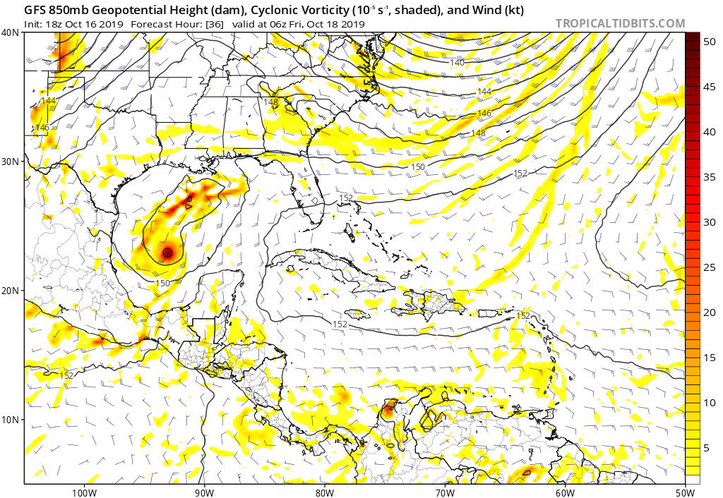
The GFS depiction of 96l phasing with the front is interesting. Note the southern low/vorticity (what we are tracking now) gets absorbed by some frontal vorticity that develops to the north seemingly out of nowhere. Otherwise the southern vorticity would be heading ENE towards the west coast of Florida and possibly organizing.
2 likes
Re: ATL: INVEST 96L - Models
The 18Z Euro is about the strongest and fastest Euro yet with it down to 997 mb just S of the SE tip of LA before landfall over the FL panhandle near 3 PM on Saturday. Also, it gives the heaviest rainfall for the SE as a whole of any Euro run yet.
1 likes
Personal Forecast Disclaimer:
The posts in this forum are NOT official forecasts and should not be used as such. They are just the opinion of the poster and may or may not be backed by sound meteorological data. They are NOT endorsed by any professional institution or storm2k.org. For official information, please refer to the NHC and NWS products.
The posts in this forum are NOT official forecasts and should not be used as such. They are just the opinion of the poster and may or may not be backed by sound meteorological data. They are NOT endorsed by any professional institution or storm2k.org. For official information, please refer to the NHC and NWS products.
-
cycloneye

- Admin

- Posts: 149275
- Age: 69
- Joined: Thu Oct 10, 2002 10:54 am
- Location: San Juan, Puerto Rico
Re: ATL: INVEST 96L - Models
Great consensus among the Bams, HWRF, GFS, HMON guidance on the track at 00z.

1 likes
Visit the Caribbean-Central America Weather Thread where you can find at first post web cams,radars
and observations from Caribbean basin members Click Here
and observations from Caribbean basin members Click Here
Re: ATL: INVEST 96L - Models
LarryWx wrote:The 18Z Euro is about the strongest and fastest Euro yet with it down to 997 mb just S of the SE tip of LA before landfall over the FL panhandle near 3 PM on Saturday. Also, it gives the heaviest rainfall for the SE as a whole of any Euro run yet.
Supporting the stronger, wetter, and faster 18Z Euro: the 18Z EPS is the most active of at least the last 4 runs with numerous members at sub 1003 mb and a pretty large number (I can't count them) sub 999. This is looking to have the most effect on a good portion of the SE US of any tropical cyclone yet this season.
1 likes
Personal Forecast Disclaimer:
The posts in this forum are NOT official forecasts and should not be used as such. They are just the opinion of the poster and may or may not be backed by sound meteorological data. They are NOT endorsed by any professional institution or storm2k.org. For official information, please refer to the NHC and NWS products.
The posts in this forum are NOT official forecasts and should not be used as such. They are just the opinion of the poster and may or may not be backed by sound meteorological data. They are NOT endorsed by any professional institution or storm2k.org. For official information, please refer to the NHC and NWS products.
Re: ATL: INVEST 96L - Models
0Z UKMET: similar to last run/987 mb:
NEW TROPICAL CYCLONE FORECAST TO DEVELOP AFTER 30 HOURS
FORECAST POSITION AT T+ 30 : 24.4N 92.1W
LEAD CENTRAL MAXIMUM WIND
VERIFYING TIME TIME POSITION PRESSURE (MB) SPEED (KNOTS)
-------------- ---- -------- ------------- -------------
1200UTC 18.10.2019 36 25.6N 90.7W 1001 33
0000UTC 19.10.2019 48 28.0N 86.8W 993 47
1200UTC 19.10.2019 60 30.0N 84.4W 987 44
0000UTC 20.10.2019 72 32.0N 81.8W 995 41
1200UTC 20.10.2019 84 34.4N 77.6W 998 39
0000UTC 21.10.2019 96 36.4N 73.4W 999 41
1200UTC 21.10.2019 108 36.4N 70.3W 1003 36
0000UTC 22.10.2019 120 36.0N 68.5W 1008 31
1200UTC 22.10.2019 132 35.6N 69.2W 1012 31
0000UTC 23.10.2019 144 CEASED TRACKING
0 likes
Personal Forecast Disclaimer:
The posts in this forum are NOT official forecasts and should not be used as such. They are just the opinion of the poster and may or may not be backed by sound meteorological data. They are NOT endorsed by any professional institution or storm2k.org. For official information, please refer to the NHC and NWS products.
The posts in this forum are NOT official forecasts and should not be used as such. They are just the opinion of the poster and may or may not be backed by sound meteorological data. They are NOT endorsed by any professional institution or storm2k.org. For official information, please refer to the NHC and NWS products.
Re: ATL: INVEST 96L - Models
0Z Euro: way faster than prior runs and strongest run yet at 990 mb!
2 likes
Personal Forecast Disclaimer:
The posts in this forum are NOT official forecasts and should not be used as such. They are just the opinion of the poster and may or may not be backed by sound meteorological data. They are NOT endorsed by any professional institution or storm2k.org. For official information, please refer to the NHC and NWS products.
The posts in this forum are NOT official forecasts and should not be used as such. They are just the opinion of the poster and may or may not be backed by sound meteorological data. They are NOT endorsed by any professional institution or storm2k.org. For official information, please refer to the NHC and NWS products.

Re: ATL: INVEST 96L - Models
00Z GFS has a 999 MB low coming in just north of Tampa, and the HWRF is showing a weaker system as well. Hopefully no TS winds if the pressure is only 999.
0 likes

Re: ATL: INVEST 96L - Models
6z GFS better organized/slightly stronger 

Sent from my iPad using Tapatalk
Sent from my iPad using Tapatalk
1 likes
-
northjaxpro

- S2K Supporter
- Posts: 8900
- Joined: Mon Sep 27, 2010 11:21 am
- Location: Jacksonville, FL
Re: ATL: INVEST 96L - Models
0 likes
NEVER, EVER SAY NEVER in the tropics and weather in general, and most importantly, with life itself!!
________________________________________________________________________________________
Fay 2008 Beryl 2012 Debby 2012 Colin 2016 Hermine 2016 Julia 2016 Matthew 2016 Irma 2017 Dorian 2019
________________________________________________________________________________________
Fay 2008 Beryl 2012 Debby 2012 Colin 2016 Hermine 2016 Julia 2016 Matthew 2016 Irma 2017 Dorian 2019
-
Aric Dunn
- Category 5
- Posts: 21238
- Age: 43
- Joined: Sun Sep 19, 2004 9:58 pm
- Location: Ready for the Chase.
- Contact:
Re: ATL: INVEST 96L - Models
6z HMON brings it to 985 and a hurricane just before landfall. Does someone jumping around right after it peaks near the coast.
But point being. Conditions might just be enough to allow a minimal hurricane. Its forward motion is key. If it moves with all levels of shear than it can.
But point being. Conditions might just be enough to allow a minimal hurricane. Its forward motion is key. If it moves with all levels of shear than it can.
2 likes
Note: If I make a post that is brief. Please refer back to previous posts for the analysis or reasoning. I do not re-write/qoute what my initial post said each time.
If there is nothing before... then just ask
Space & Atmospheric Physicist, Embry-Riddle Aeronautical University,
I believe the sky is falling...
If there is nothing before... then just ask
Space & Atmospheric Physicist, Embry-Riddle Aeronautical University,
I believe the sky is falling...

Re: ATL: INVEST 96L - Models
Aric Dunn wrote:6z HMON brings it to 985 and a hurricane just before landfall. Does someone jumping around right after it peaks near the coast.
But point being. Conditions might just be enough to allow a minimal hurricane. Its forward motion is key. If it moves with all levels of shear than it can.
I don’t recall the HMON being listed among the most reliable of models. Too many memories of Michael seem to have people on edge. Not that they can’t be blamed
0 likes
-
jconsor
- Professional-Met

- Posts: 578
- Joined: Mon Jun 30, 2008 9:31 pm
- Location: Jerusalem, Israel
- Contact:
Re: ATL: INVEST 96L - Models
Two of the past three HWRF runs deepen it to the low 980s with winds reaching lower end cat 1 in the NE gulf, though weakening a little before landfall.
Aric Dunn wrote:6z HMON brings it to 985 and a hurricane just before landfall. Does someone jumping around right after it peaks near the coast.
But point being. Conditions might just be enough to allow a minimal hurricane. Its forward motion is key. If it moves with all levels of shear than it can.
2 likes
-
Aric Dunn
- Category 5
- Posts: 21238
- Age: 43
- Joined: Sun Sep 19, 2004 9:58 pm
- Location: Ready for the Chase.
- Contact:
Re: ATL: INVEST 96L - Models
6z euro brings it down to 985. But also reforms center farther north.
0 likes
Note: If I make a post that is brief. Please refer back to previous posts for the analysis or reasoning. I do not re-write/qoute what my initial post said each time.
If there is nothing before... then just ask
Space & Atmospheric Physicist, Embry-Riddle Aeronautical University,
I believe the sky is falling...
If there is nothing before... then just ask
Space & Atmospheric Physicist, Embry-Riddle Aeronautical University,
I believe the sky is falling...

Re: ATL: INVEST 96L - Models
Nimbus wrote:00Z GFS has a 999 MB low coming in just north of Tampa, and the HWRF is showing a weaker system as well. Hopefully no TS winds if the pressure is only 999.
Given there will be baroclinic forcing, I would expect TS winds with a 999mb low.
0 likes

Re: ATL: INVEST 96L - Models
jconsor wrote:Two of the past three HWRF runs deepen it to the low 980s with winds reaching lower end cat 1 in the NE gulf, though weakening a little before landfall.Aric Dunn wrote:6z HMON brings it to 985 and a hurricane just before landfall. Does someone jumping around right after it peaks near the coast.
But point being. Conditions might just be enough to allow a minimal hurricane. Its forward motion is key. If it moves with all levels of shear than it can.
00z UKMET brings it down to 987 mb in the NE GOM - for a global that's pretty low and generally indicative of a CAT 1 hurricane.
https://weather.us/model-charts/gbr/florida/sea-level-pressure/20191019-0900z.html
0 likes
-
chris_fit

- Category 5
- Posts: 3261
- Age: 43
- Joined: Wed Sep 10, 2003 11:58 pm
- Location: Tampa Bay Area, FL
Re: ATL: SIXTEEN - Models
I just wanna say the GFS has been sniffing 'something' out for the longest time in the W Car and/or GoM - for weeks back - with a timeline of the 17-18th.... and well, look what we have here. Whether this was a case of 'a broken clock is right twice a day' or not - I dunno - but good job GFS on the long term sniffage.
6 likes
Re: ATL: INVEST 96L - Models
Jr0d wrote:Nimbus wrote:00Z GFS has a 999 MB low coming in just north of Tampa, and the HWRF is showing a weaker system as well. Hopefully no TS winds if the pressure is only 999.
Given there will be baroclinic forcing, I would expect TS winds with a 999mb low.
There is a digging upper level low providing some shear from the south, but most of the models still show some kind of circulation persisting that will make landfall(now not in the Tampa bay area).
0 likes
Who is online
Users browsing this forum: No registered users and 241 guests