97L INVEST 191024 1200 19.8N 93.8W ATL 25 NA
ATL: OLGA - Post-Tropical - Discussion
Moderator: S2k Moderators
-
Nancy Smar

- Category 5

- Posts: 1081
- Age: 25
- Joined: Wed Aug 16, 2017 10:03 pm
ATL: OLGA - Post-Tropical - Discussion
Last edited by Nancy Smar on Fri Oct 25, 2019 9:39 am, edited 1 time in total.
0 likes
-
Dean4Storms
- S2K Supporter

- Posts: 6358
- Age: 63
- Joined: Sun Aug 31, 2003 1:01 pm
- Location: Miramar Bch. FL
Re: ATL: INVEST 97L - Discussion
I was about to post that this should get designated an Invest anytime now.
0 likes
-
tropicwatch

- Category 5
- Posts: 3427
- Age: 62
- Joined: Sat Jun 02, 2007 10:01 am
- Location: The Villages, Florida
- Contact:
Re: ATL: INVEST 97L - Discussion
Definitely tagged quicker then Nestor was that had a higher percentage of development.
0 likes
Tropicwatch
Agnes 72', Eloise 75, Elena 85', Kate 85', Charley 86', Florence 88', Beryl 94', Dean 95', Erin 95', Opal 95', Earl 98', Georges 98', Ivan 2004', Arlene 2005', Dennis 2005', Ida 2009' Debby 2012' Irma 2017' Michael 2018'
Agnes 72', Eloise 75, Elena 85', Kate 85', Charley 86', Florence 88', Beryl 94', Dean 95', Erin 95', Opal 95', Earl 98', Georges 98', Ivan 2004', Arlene 2005', Dennis 2005', Ida 2009' Debby 2012' Irma 2017' Michael 2018'
-
Dean4Storms
- S2K Supporter
- Posts: 6358
- Age: 63
- Joined: Sun Aug 31, 2003 1:01 pm
- Location: Miramar Bch. FL
-
Nancy Smar
- Category 5
- Posts: 1081
- Age: 25
- Joined: Wed Aug 16, 2017 10:03 pm
Re: ATL: INVEST 97L - Discussion
TXNT29 KNES 241217
TCSNTL
A. TROPICAL DISTURBANCE (97L)
B. 24/1201Z
C. 20.0N
D. 92.7W
E. THREE/GOES-E
F. T1.0/1.0/D1.0/24HRS
G. IR/EIR/SWIR
H. REMARKS...SYSTEM CHARACTERIZED BY A MID-LEVEL CENTER WITH GREATER
THAN 2/10 BANDING ON A LOG-10 SCALE. DT=1.0 MET AND PT AGREE. FT IS
BASED ON DT.
I. ADDL POSITIONS
NIL
...FISHER
0 likes

Re: ATL: INVEST 97L - Discussion
Looking at the first vis sat loop it has a nice closed surface circulation with southerly inflow into the convection, CoC might still be on the broad side.

0 likes
-
MarioProtVI
- Category 5
- Posts: 1039
- Age: 24
- Joined: Sun Sep 29, 2019 7:33 pm
- Location: New Jersey
Re: ATL: INVEST 97L - Discussion
I don’t see any indication this has a closed circulation. Satellite data shows that it is just a broad trough and I don’t see this developing quick enough before the cold front absorbs this system tomorrow. Did show some 30 kt winds but might be transient.
0 likes

-
Nancy Smar
- Category 5
- Posts: 1081
- Age: 25
- Joined: Wed Aug 16, 2017 10:03 pm
Re: ATL: INVEST 97L - Discussion
Early morning visible satellite images indicate that the
circulation of the low pressure area in the Bay of Campeche has
become a little better defined. The associated showers and
thunderstorms continue to show signs of organization, and this
system could become a short-lived tropical depression before it
merges with a cold front by late Friday.
* Formation chance through 48 hours...medium...50 percent.
* Formation chance through 5 days...medium...50 percent.
0 likes
Re: ATL: INVEST 97L - Discussion
Some interest in the Melbourne FL, NWS Disco: Sun-Wed... A low pressure with an attached cold front will be
lifting to the northeast from the eastern states of the Midwest on
Sun. This front will drag from the gulf states and move east and as
it does, the local wind pattern will shift from the south and bring
even more moisture and instability to east central FL. By Mon
morning, the aforementioned low will exit the northeast US and a low
will develop over the northeast Gulf along the front. This low will
then reach the southeast US by Tue morning. After this, GFS and
Euro don`t agree on what this low will do. GFS shows the low lifting
more towards the northeast and by Wed its associated front will push
towards FL. This solution will be great for us as dew points could
drop to the upper 60s and max temps could remain below 80. However,
the Euro develops a broad area of low pressure and instead builds a
ridge across the local area from the northeast. So the forecast was
taking more towards the GFS solution.
Hopefully the front pushes through Florida and brings relief from the temperatures and humidity. Not sure what it would mean in the Euro solution, though this isn't considering the "tropical Low", but a different area of low pressure. BTW, the Recon investigation position is to the NW of it's current position. So there is uncertainty with the forecast, but it does seem that the BOC low should turn north/northeast ahead of the cold front but again, the front will die in the eastern GOM, if not only for a few days which could make the scenario more complex. Interesting setup as they usually are as we move into fall.
0 likes
-
PTrackerLA

- Category 5
- Posts: 5281
- Age: 42
- Joined: Thu Oct 10, 2002 8:40 pm
- Location: Lafayette, LA
Re: ATL: INVEST 97L - Discussion
Already looks better than Nestor ever did IMO. Looks like moisture will be tapped from this system with the front tomorrow enhancing rains in SE Texas and LA.
0 likes
Re: ATL: INVEST 97L - Discussion
Developing pretty rapidly this am - looks to be moving slowly N-NW. Euro and TABM bring it on a similar path as Nestor.
http://rammb.cira.colostate.edu/ramsdis/online/loop.asp?data_folder=tropical/tropical_ge_4km_visir2_floater_2&width=640&height=480&number_of_images_to_display=12
http://rammb.cira.colostate.edu/ramsdis/online/loop.asp?data_folder=tropical/tropical_ge_4km_visir2_floater_2&width=640&height=480&number_of_images_to_display=12
1 likes
-
Aric Dunn
- Category 5
- Posts: 21238
- Age: 43
- Joined: Sun Sep 19, 2004 9:58 pm
- Location: Ready for the Chase.
- Contact:
Re: ATL: INVEST 97L - Discussion
Interesting.. looks closed and quickly organizing..
Some overshooting tops which appear to be rotating around in the sw side of main ball of convection
Some overshooting tops which appear to be rotating around in the sw side of main ball of convection
0 likes
Note: If I make a post that is brief. Please refer back to previous posts for the analysis or reasoning. I do not re-write/qoute what my initial post said each time.
If there is nothing before... then just ask
Space & Atmospheric Physicist, Embry-Riddle Aeronautical University,
I believe the sky is falling...
If there is nothing before... then just ask
Space & Atmospheric Physicist, Embry-Riddle Aeronautical University,
I believe the sky is falling...
-
Emmett_Brown

- Category 5
- Posts: 1433
- Joined: Wed Aug 24, 2005 9:10 pm
- Location: Sarasota FL
Re: ATL: INVEST 97L - Discussion
Unlike Nestor, 97L looks fully tropical. Shear not bad for the next 24 hours.
Last edited by Emmett_Brown on Thu Oct 24, 2019 10:12 am, edited 1 time in total.
1 likes


Re: ATL: INVEST 97L - Discussion
Pretty impressive and trying to get it's act together this a.m. The LLC appears to be pretty close to 94W and there are hints of small banding features on it's south side. Seems to me that it might be a small core which would suggest the possibility of a relatively quick spin-up. Only thing is that the CDO looks like it wants to already lift to the north. We'll have to see if continued convection can maintain itself over center (or for any developing LLC to begin moving north or NNE in tandem). Aided by a westward moving mid/upper level low to it's east, the outflow in nearly all quadrants is quite divergent. For the immediate future, there's no dry air getting entrained into this developing low. I'd guess it has a 24-36 hr window of opportunity to form but overall conditions look about as conducive right now as there gonna be. I could potentially see a quick spin-up to T.S. intensity. Something this small (inner core, not overall envelope) is generally better initialized by GFS then EURO but i'm not sure that any model has too much a handle on it at the moment. As good as it looks though, I can't help think that it's vertical column is going to get progressively tilted north/south throughout the day; with the MLC trying to lift away from the LLC. Will be an interesting day to sit back and observe.
3 likes
Andy D
(For official information, please refer to the NHC and NWS products.)
(For official information, please refer to the NHC and NWS products.)
Re: ATL: INVEST 97L - Discussion
New convection firing up near/over what i'd suggest is still a ill defined center close to 20.5N and 94W. No doubt there's a healthy low level inflow coming into the southwest quadrant from the northwest, west, and southwest. Satellite bears out that there's certainly NO issue with present surface convergence. Also, zero dry air entraining into the developing circulation either. Biggest question is whether it can develop an aligned vertical core enough to deepen during today into tonight. This may or may not fully develop but one's things for sure, there's no comparison to "Cold Front Low Nestor" which was pretty much devoid of tropical features. This on the other hand is trying to develop within a purely tropical environment.
0 likes
Andy D
(For official information, please refer to the NHC and NWS products.)
(For official information, please refer to the NHC and NWS products.)
-
Aric Dunn
- Category 5
- Posts: 21238
- Age: 43
- Joined: Sun Sep 19, 2004 9:58 pm
- Location: Ready for the Chase.
- Contact:
Re: ATL: INVEST 97L - Discussion
We need recon. This is almost certainly a td right now.
0 likes
Note: If I make a post that is brief. Please refer back to previous posts for the analysis or reasoning. I do not re-write/qoute what my initial post said each time.
If there is nothing before... then just ask
Space & Atmospheric Physicist, Embry-Riddle Aeronautical University,
I believe the sky is falling...
If there is nothing before... then just ask
Space & Atmospheric Physicist, Embry-Riddle Aeronautical University,
I believe the sky is falling...
-
tropicwatch
- Category 5
- Posts: 3427
- Age: 62
- Joined: Sat Jun 02, 2007 10:01 am
- Location: The Villages, Florida
- Contact:
Re: ATL: INVEST 97L - Discussion
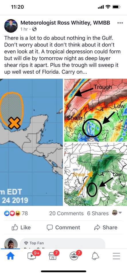
This is from one of our local meteorologist here in Panama City. I hope he is right but I don't know if I would make such a definitive statement at this stage of the game.
0 likes
Tropicwatch
Agnes 72', Eloise 75, Elena 85', Kate 85', Charley 86', Florence 88', Beryl 94', Dean 95', Erin 95', Opal 95', Earl 98', Georges 98', Ivan 2004', Arlene 2005', Dennis 2005', Ida 2009' Debby 2012' Irma 2017' Michael 2018'
Agnes 72', Eloise 75, Elena 85', Kate 85', Charley 86', Florence 88', Beryl 94', Dean 95', Erin 95', Opal 95', Earl 98', Georges 98', Ivan 2004', Arlene 2005', Dennis 2005', Ida 2009' Debby 2012' Irma 2017' Michael 2018'
Re: ATL: INVEST 97L - Discussion
Aric Dunn wrote:We need recon. This is almost certainly a td right now.
I don't know Aric...... I mean, yeah there's west winds pulling into the circ and some convection right over where a COC seems to be trying to form. I just think the core is not quite defined yet. I'd like to see the convection maintain and expand over center but the primary CDO is east and north of the LLC and moving north. It sure is trying to make a good go of it though.
0 likes
Andy D
(For official information, please refer to the NHC and NWS products.)
(For official information, please refer to the NHC and NWS products.)
Who is online
Users browsing this forum: No registered users and 22 guests