ATL: PABLO - Post-Tropical - Discussion
Moderator: S2k Moderators
-
EquusStorm
- Category 5

- Posts: 1649
- Age: 35
- Joined: Thu Nov 07, 2013 1:04 pm
- Location: Jasper, AL
- Contact:
Re: ATL: INVEST 98L - Discussion
I think post-analysis will find it peaked before even being classified, but part of me hopes it somehow hits hurricane status briefly though not likely. Guess we'll see.
2 likes
Colors of lost purpose on the canvas of irrelevance
Not a meteorologist, in fact more of an idiot than anything. You should probably check with the NHC or a local NWS office for official information.
Not a meteorologist, in fact more of an idiot than anything. You should probably check with the NHC or a local NWS office for official information.
-
cycloneye

- Admin

- Posts: 149275
- Age: 69
- Joined: Thu Oct 10, 2002 10:54 am
- Location: San Juan, Puerto Rico
Re: ATL: PABLO - Tropical Storm - Discussion
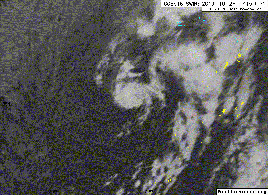
Tropical Storm Pablo Discussion Number 1
NWS National Hurricane Center Miami FL AL182019
500 PM AST Fri Oct 25 2019
High-resolution visible satellite imagery gave us a surprise today.
A tropical cyclone has formed within a larger extratropical cyclone
in the northeastern Atlantic. This is not unique and has occurred
several times in the past, primarily during the latter part of the
hurricane season. Pablo is a very small-scale tropical cyclone, but
ASCAT data clearly show a well-defined but small circulation with
40-kt winds embedded within the larger low. This is the intensity
assigned to the cyclone for this advisory. The cloud pattern
consists of an eye-type feature surrounded by a ring of deep
convection. Given the small size of the cyclone, and the baroclinic
environment, the intensity forecast is highly uncertain. At this
time, the NHC forecast calls for a small increase in the winds and
for the cyclone to become extratropical in about 36 hours. However,
this transition could occur sooner than anticipated.
Pablo is currently moving toward the east-southeast at about 9 kt
while embedded within the circulation of the larger extratropical
low. Pablo should then turn toward the northeast with some increase
in forward speed, as indicated by the multi-model consensus aids.
In fact, all the models are in very good agreement, and the NHC
forecast is in the middle of the guidance envelope.
Given that Pablo is embedded within a large extratropical low,
which itself is forecast to bring strong winds to the Azores, the
Portuguese Institute for the Sea and Atmosphere (IPMA) has included
the effects of this small cyclone in their products. Those products
already account for the strong winds and high waves.
FORECAST POSITIONS AND MAX WINDS
INIT 25/2100Z 35.8N 32.2W 40 KT 45 MPH
12H 26/0600Z 35.3N 30.7W 45 KT 50 MPH
24H 26/1800Z 36.3N 26.8W 45 KT 50 MPH
36H 27/0600Z 40.0N 23.5W 45 KT 50 MPH
48H 27/1800Z 43.0N 21.5W 40 KT 45 MPH...POST-TROP/EXTRATROP
72H 28/1800Z 46.5N 20.0W 40 KT 45 MPH...POST-TROP/EXTRATROP
96H 29/1800Z...DISSIPATED
$$
Forecaster Avila
0 likes
Visit the Caribbean-Central America Weather Thread where you can find at first post web cams,radars
and observations from Caribbean basin members Click Here
and observations from Caribbean basin members Click Here
-
EquusStorm
- Category 5
- Posts: 1649
- Age: 35
- Joined: Thu Nov 07, 2013 1:04 pm
- Location: Jasper, AL
- Contact:
Re: ATL: PABLO - Tropical Storm - Discussion
Two active named storms simultaneously is pretty impressive for October 25.
1 likes
Colors of lost purpose on the canvas of irrelevance
Not a meteorologist, in fact more of an idiot than anything. You should probably check with the NHC or a local NWS office for official information.
Not a meteorologist, in fact more of an idiot than anything. You should probably check with the NHC or a local NWS office for official information.

Re: ATL: PABLO - Tropical Storm - Discussion
No way this is only 40kt.
3 likes
The above post is not official and should not be used as such. It is the opinion of the poster and may or may not be backed by sound meteorological data. It is not endorsed by any professional institution or storm2k.org. For official information, please refer to the NHC and NWS products.
-
TheStormExpert
Re: ATL: PABLO - Tropical Storm - Discussion
Hammy wrote:No way this is only 40kt.
Likely a strong TS imo.
0 likes
-
Sciencerocks
- Category 5
- Posts: 10181
- Age: 40
- Joined: Thu Jul 06, 2017 1:51 am

Re: ATL: PABLO - Tropical Storm - Discussion
I don't know if anyone has made the comparison as yet, but size-wise this is pretty much the complete opposite of Lorenzo, and in the same general area. How odd.
0 likes


-
TallyTracker
- Category 2

- Posts: 787
- Joined: Thu Oct 11, 2018 2:46 pm
Re: ATL: PABLO - Tropical Storm - Discussion
Pablo is looking much improved again. I’m guessing ASCAT is under doing the intensity. I think it’s likely 65-75 mph right now.
0 likes
Fran '96, Georges '98, Gordon '00, Gabrielle '01, Charley '04, Frances '04, Jeanne '04, Barry '07, Fay '08, Debby '12, Matthew '16, Emily '17, Irma '17, Michael ‘18, Elsa ‘21, Fred ‘21, Mindy ‘21, Nicole ‘22, Idalia ‘23, Debby ‘24, Helene ‘24

Re: ATL: PABLO - Tropical Storm - Discussion
TallyTracker wrote:
Pablo is looking much improved again. I’m guessing ASCAT is under doing the intensity. I think it’s likely 65-75 mph right now.
Maybe we could see an upgrade to 50 kt or higher for the next advisory, but because of the shallow convection and small size in contrast to good organization and an on-and-off eye, I’m just not sure.
0 likes
Irene '11 Sandy '12 Hermine '16 5/15/2018 Derecho Fay '20 Isaias '20 Elsa '21 Henri '21 Ida '21
I am only a meteorology enthusiast who knows a decent amount about tropical cyclones. Look to the professional mets, the NHC, or your local weather office for the best information.
I am only a meteorology enthusiast who knows a decent amount about tropical cyclones. Look to the professional mets, the NHC, or your local weather office for the best information.
-
tolakram
- Admin
- Posts: 20178
- Age: 62
- Joined: Sun Aug 27, 2006 8:23 pm
- Location: Florence, KY (name is Mark)
Re: ATL: PABLO - Tropical Storm - Discussion
Already getting dark but here's the live visible
https://rammb-slider.cira.colostate.edu/?sat=goes-16&z=5&im=30&ts=1&st=0&et=0&speed=130&motion=loop&map=1&lat=0&opacity%5B0%5D=1&hidden%5B0%5D=0&pause=0&slider=-1&hide_controls=0&mouse_draw=0&follow_feature=0&follow_hide=0&s=rammb-slider&sec=full_disk&p%5B0%5D=band_02&x=17712&y=4055
https://rammb-slider.cira.colostate.edu/?sat=goes-16&z=5&im=30&ts=1&st=0&et=0&speed=130&motion=loop&map=1&lat=0&opacity%5B0%5D=1&hidden%5B0%5D=0&pause=0&slider=-1&hide_controls=0&mouse_draw=0&follow_feature=0&follow_hide=0&s=rammb-slider&sec=full_disk&p%5B0%5D=band_02&x=17712&y=4055
1 likes
M a r k
- - - - -
Join us in chat: Storm2K Chatroom Invite. Android and IOS apps also available.
The posts in this forum are NOT official forecasts and should not be used as such. Posts are NOT endorsed by any professional institution or STORM2K.org. For official information and forecasts, please refer to NHC and NWS products.

Re: ATL: PABLO - Tropical Storm - Discussion
A lot more discussion on Pablo before he was Pablo officially.
Not going to be surprised if he peaks as a category one Hurricane. But I know these small, shallow storms can be hard to read just based on satellite.
Not going to be surprised if he peaks as a category one Hurricane. But I know these small, shallow storms can be hard to read just based on satellite.
1 likes
-
Sciencerocks
- Category 5
- Posts: 10181
- Age: 40
- Joined: Thu Jul 06, 2017 1:51 am
-
cycloneye
- Admin
- Posts: 149275
- Age: 69
- Joined: Thu Oct 10, 2002 10:54 am
- Location: San Juan, Puerto Rico
Re: ATL: PABLO - Tropical Storm - Discussion
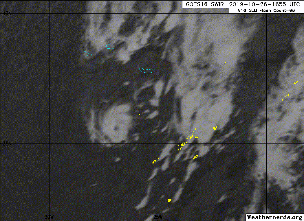
Tropical Storm Pablo Discussion Number 5
NWS National Hurricane Center Miami FL AL182019
500 PM AST Sat Oct 26 2019
Pablo has become a little better organized during the past several
hours, with a small eye becoming somewhat better defined. However,
the various satellite intensity estimates have remained near 45 kt.
Based on the increased organization since the the 40-45 kt winds
seen in earlier scatterometer data, the initial intensity is now
set at 50 kt.
Pablo has turned northeastward and accelerated, with the initial
motion now 055/22. This motion should bring the small core of the
storm near or over the eastern Azores during the next several hours.
After that, the tropical storm should turn northward and eventually
northwestward as a developing mid-latitude low to the west becomes
the dominant steering mechanism. The guidance has shifted a bit to
the east since the previous advisory, and the new forecast track is
similar to, but east of, the previous forecast.
Pablo should slow weaken as it moves into an environment of colder
sea surface temperatures and increasing shear, and a developing
frontal zone near the cyclone should lead to the system becoming
extratropical by 36 h. The global models continue to forecast the
system to merge with the mid-latitude low to the west between
48-72 h, so the intensity forecast again shows dissipation during
that time.
Given that Pablo is embedded within a large extratropical low,
which itself is forecast to bring strong winds to the Azores, the
Portuguese Institute for the Sea and Atmosphere (IPMA) has included
the effects of this small cyclone in their products. Those products
already account for the strong winds and high waves expected in the
Azores.
FORECAST POSITIONS AND MAX WINDS
INIT 26/2100Z 36.3N 25.6W 50 KT 60 MPH
12H 27/0600Z 39.3N 22.6W 50 KT 60 MPH
24H 27/1800Z 42.7N 20.5W 45 KT 50 MPH
36H 28/0600Z 44.9N 20.3W 40 KT 45 MPH...POST-TROP/EXTRATROP
48H 28/1800Z 46.3N 21.6W 40 KT 45 MPH...POST-TROP/EXTRATROP
72H 29/1800Z...DISSIPATED
$$
Forecaster Beven
0 likes
Visit the Caribbean-Central America Weather Thread where you can find at first post web cams,radars
and observations from Caribbean basin members Click Here
and observations from Caribbean basin members Click Here
-
Sciencerocks
- Category 5
- Posts: 10181
- Age: 40
- Joined: Thu Jul 06, 2017 1:51 am

-
cycloneye
- Admin
- Posts: 149275
- Age: 69
- Joined: Thu Oct 10, 2002 10:54 am
- Location: San Juan, Puerto Rico
Re: ATL: PABLO - Tropical Storm - Discussion
Tropical Storm Pablo Discussion Number 6
NWS National Hurricane Center Miami FL AL182019
1100 PM AST Sat Oct 26 2019
Pablo passed just to the southeast of Santa Maria island in the
eastern Azores earlier this evening and is now accelerating away
from the islands. A pair of ASCAT passes around 2100-2200 UTC showed
that Pablo was stronger than previously estimated, with maximum
winds above 50 kt. The latest SATCON estimate also supports a higher
intensity of 55 kt, so that is the value used for this advisory.
Pablo's higher intensity is not necessarily an indication of further
intensification, and its cloud pattern has actually slightly
degraded since earlier today. The NHC forecast is based primarily on
the dynamical model consensus, and nearly all of those models
indicate that Pablo will maintain its strength overnight and then
gradually weaken on Sunday and Monday. Pablo's upper-air environment
is unusually cold, and this will likely allow it to maintain
convection for longer than typically expected, given that the SHIPS
SST analysis is already down to 22 deg C. Much colder waters are
ahead, and Pablo is still forecast to become post-tropical within
36 h, though it is worth noting that a few dynamical models indicate
it could try to maintain its tropical structure over very cold
waters a little bit longer.
The tropical storm has moved to the right of and faster than the
previous forecast track and the initial motion estimate is
050/25 kt. Pablo should curve counter-clockwise around the eastern
side of the larger extratropical low it is embedded within during
the next couple of days. Most of the guidance is farther to the
right than it was before and the NHC forecast is therefore also
shifted substantially in that direction, but not as far as the
multi-model consensus. Further adjustments in the track forecast may
be required if current model trends continue.
FORECAST POSITIONS AND MAX WINDS
INIT 27/0300Z 38.2N 22.6W 55 KT 65 MPH
12H 27/1200Z 41.0N 20.2W 55 KT 65 MPH
24H 28/0000Z 44.1N 19.2W 50 KT 60 MPH
36H 28/1200Z 46.0N 20.0W 45 KT 50 MPH...POST-TROP/EXTRATROP
48H 29/0000Z 47.1N 21.5W 40 KT 45 MPH...POST-TROP/EXTRATROP
72H 30/0000Z...DISSIPATED
$$
Forecaster Zelinsky
0 likes
Visit the Caribbean-Central America Weather Thread where you can find at first post web cams,radars
and observations from Caribbean basin members Click Here
and observations from Caribbean basin members Click Here
-
1900hurricane

- Category 5
- Posts: 6063
- Age: 34
- Joined: Fri Feb 06, 2015 12:04 pm
- Location: Houston, TX
- Contact:
Re: ATL: PABLO - Tropical Storm - Discussion
The eye feature has disappeared again, but convection has gotten deeper, now staying colder than -50ºC. Still not what you would expect in the tropics, but the intensity might be about as high as it's going to get now.
0 likes
Contract Meteorologist. TAMU & MSST. Fiercely authentic, one of a kind. We are all given free will, so choose a life meant to be lived. We are the Masters of our own Stories.
Opinions expressed are mine alone.
Follow me on Twitter at @1900hurricane : Read blogs at https://1900hurricane.wordpress.com/
Opinions expressed are mine alone.
Follow me on Twitter at @1900hurricane : Read blogs at https://1900hurricane.wordpress.com/
-
HurricaneBelle

- S2K Supporter

- Posts: 1209
- Joined: Sun Aug 27, 2006 6:12 pm
- Location: Clearwater, FL
Re: ATL: PABLO - Tropical Storm - Discussion
NHC really missed an opportunity in their latest advisory when they failed to headline it "...PABLO CRUISING ACROSS THE NORTHEAST ATLANTIC..."
2 likes
-
Sciencerocks
- Category 5
- Posts: 10181
- Age: 40
- Joined: Thu Jul 06, 2017 1:51 am
Re: ATL: PABLO - Tropical Storm - Discussion
Looks like it maybe close to a hurricane with a nice eye popping out with the deeper convection.
1 likes

Re: ATL: PABLO - Tropical Storm - Discussion
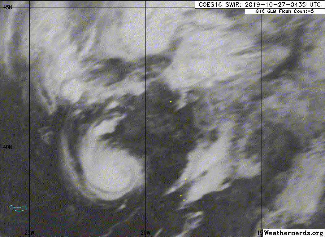
Tropical Storm Pablo Discussion Number 7
NWS National Hurricane Center Miami FL AL182019
500 AM AST Sun Oct 27 2019
Microwave satellite imagery indicates that Pablo has maintained a
small mid-level eye feature for at least the past 18 hours, and
the eye has also been evident in infrared imagery for the past 6
hours. The most recent Dvorak satellite intensity estimate was T3.0,
which was held down due to constraints even though the eye pattern
supports an intensity of 65 kt. Latest UW-CIMSS objective ADT and
SATCON intensity estimates are T4.4/75 kt and 64 kt, respectively.
Based on a blend of the TAFB and UW-CIMSS values, along with the
5- to 8-nmi-diameter eye, the intensity has been increased to 60 kt,
which could be conservative due to the the cyclone's relatively fast
forward speed.
Pablo has continued to accelerate and the initial motion estimate is
now 045/35 kt. The latest model guidance remains in good agreement
that during the next 48 hours, Pablo should slow down while making a
counter-clockwise track around the northeastern periphery of the
larger extratropical low that the small cyclone is embedded within.
The tightly packed guidance suite has shifted to the right of the
previous advisory track, and the new NHC forecast track has been
adjusted in that direction, close to the various consensus models.
Pablo is currently located over 20 deg C sea-surface temperatures
(SST), with colder water near 15 deg C ahead of the cyclone. Model
forecast soundings indicate that mid- and upper-level temperatures
will be warming, and when combined with the cooler SSTs, will result
in stabilization of the troposphere. This will cause convection to
steadily weaken and erode by 12 h, resulting in Pablo degenerating
into a post-tropical extratropical low pressure system in 24 h, if
not sooner. The small cyclone is forecast to dissipate or become
absorbed by the larger parent extratropical low in the 48-72 h
forecast period.
FORECAST POSITIONS AND MAX WINDS
INIT 27/0900Z 40.7N 20.0W 60 KT 70 MPH
12H 27/1800Z 43.8N 17.6W 55 KT 65 MPH
24H 28/0600Z 46.2N 17.8W 50 KT 60 MPH...POST-TROP/EXTRATROP
36H 28/1800Z 46.9N 18.9W 45 KT 50 MPH...POST-TROP/EXTRATROP
48H 29/0600Z 48.3N 20.3W 40 KT 45 MPH...POST-TROP/EXTRATROP
72H 30/0600Z...DISSIPATED
$$
Forecaster Stewart
0 likes
Who is online
Users browsing this forum: No registered users and 225 guests