
ATL: PABLO - Post-Tropical - Discussion
Moderator: S2k Moderators
-
supercane4867
- Category 5

- Posts: 4966
- Joined: Wed Nov 14, 2012 10:43 am
-
Vince_and_Grace_fan

- Category 1

- Posts: 323
- Joined: Thu Nov 03, 2016 9:25 am
- Location: Szombathely (Hungary)

-
storminabox
- Category 1
- Posts: 263
- Joined: Sun Jul 09, 2017 10:50 pm
-
MarioProtVI
- Category 5
- Posts: 1034
- Age: 24
- Joined: Sun Sep 29, 2019 7:33 pm
- Location: New Jersey
Re: ATL: PABLO - Hurricane - Discussion
Sciencerocks wrote:https://imagizer.imageshack.com/img924/3742/oODlXt.gif
Definitely hitting that sub-17C waters in that animation there. Pablo should be gone by tomorrow or so.
0 likes
-
TallyTracker
- Category 2

- Posts: 787
- Joined: Thu Oct 11, 2018 2:46 pm
Re: ATL: PABLO - Hurricane - Discussion
Pablo is falling apart fast now. Probably will be gone by noon tomorrow at this rate. It’s been a great storm to track though! 
0 likes
Fran '96, Georges '98, Gordon '00, Gabrielle '01, Charley '04, Frances '04, Jeanne '04, Barry '07, Fay '08, Debby '12, Matthew '16, Emily '17, Irma '17, Michael ‘18, Elsa ‘21, Fred ‘21, Mindy ‘21, Nicole ‘22, Idalia ‘23, Debby ‘24, Helene ‘24


Re: ATL: PABLO - Tropical Storm - Discussion
Well, the life of Pablo has certainly been... interesting.
Yeezy approved.
Yeezy approved.
1 likes
blonde stacey (xe/xem/xir)
-
cycloneye

- Admin

- Posts: 149275
- Age: 69
- Joined: Thu Oct 10, 2002 10:54 am
- Location: San Juan, Puerto Rico
Re: ATL: PABLO - Tropical Storm - Discussion
Tropical Storm Pablo Discussion Number 10
NWS National Hurricane Center Miami FL AL182019
1100 PM AST Sun Oct 27 2019
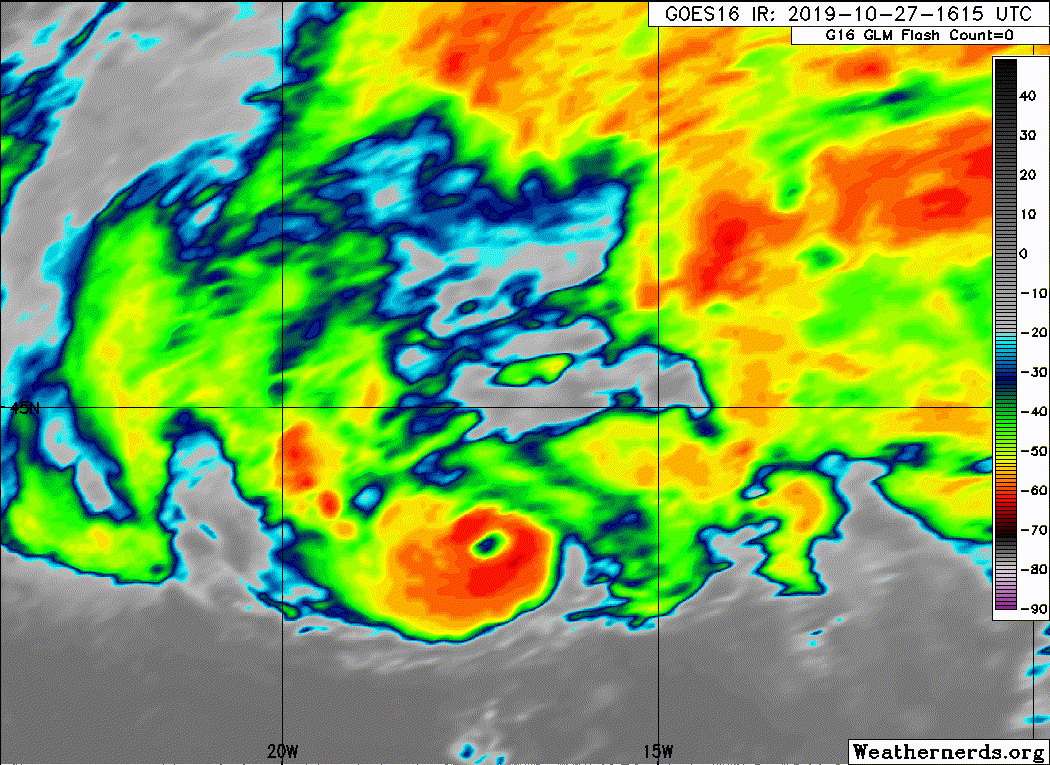
Shortly after the release of the previous advisory, deep convection
associated with Pablo finally began to decrease in both coverage and
organization. Convection has become confined to the southern
portion of the circulation and the eye is no longer apparent in
conventional satellite imagery, although a low-level eye feature was
still noted in a recent GMI microwave overpass. The initial
intensity has been reduced to 60 kt, which is a blend of the latest
Dvorak T- and CI-numbers from TAFB.
Pablo is approaching a frontal boundary that lies just to the north
of the cyclone, and is also moving over SSTs of around 17C. This
should cause the deep convection to continue to wane overnight, and
Pablo is expected to become extratropical when it merges with the
aforementioned front on Tuesday. The global models indicate that
the post-tropical cyclone will be absorbed by a much larger
extratropical low to its west by Tuesday morning.
Recent microwave and satellite fixes show that Pablo's forward speed
has begun to slow as expected, and its initial motion is now north
or 360/12 kt. The dynamical models indicate that Pablo will
continue to decelerate overnight as it moves generally northward. A
slow northward motion should then continue on Monday as Pablo merges
with the frontal zone and becomes post-tropical.
The 12- and 24-h forecast wind radii were adjusted outward to
account for the area of gale-force winds north of the frontal
boundary that Pablo is expected to merge with late Monday or early
Tuesday.
FORECAST POSITIONS AND MAX WINDS
INIT 28/0300Z 46.0N 17.1W 60 KT 70 MPH
12H 28/1200Z 47.0N 17.0W 50 KT 60 MPH...POST-TROP/EXTRATROP
24H 29/0000Z 48.2N 17.1W 45 KT 50 MPH...POST-TROP/EXTRATROP
36H 29/1200Z...DISSIPATED
$$
Forecaster Brown
NWS National Hurricane Center Miami FL AL182019
1100 PM AST Sun Oct 27 2019
Shortly after the release of the previous advisory, deep convection
associated with Pablo finally began to decrease in both coverage and
organization. Convection has become confined to the southern
portion of the circulation and the eye is no longer apparent in
conventional satellite imagery, although a low-level eye feature was
still noted in a recent GMI microwave overpass. The initial
intensity has been reduced to 60 kt, which is a blend of the latest
Dvorak T- and CI-numbers from TAFB.
Pablo is approaching a frontal boundary that lies just to the north
of the cyclone, and is also moving over SSTs of around 17C. This
should cause the deep convection to continue to wane overnight, and
Pablo is expected to become extratropical when it merges with the
aforementioned front on Tuesday. The global models indicate that
the post-tropical cyclone will be absorbed by a much larger
extratropical low to its west by Tuesday morning.
Recent microwave and satellite fixes show that Pablo's forward speed
has begun to slow as expected, and its initial motion is now north
or 360/12 kt. The dynamical models indicate that Pablo will
continue to decelerate overnight as it moves generally northward. A
slow northward motion should then continue on Monday as Pablo merges
with the frontal zone and becomes post-tropical.
The 12- and 24-h forecast wind radii were adjusted outward to
account for the area of gale-force winds north of the frontal
boundary that Pablo is expected to merge with late Monday or early
Tuesday.
FORECAST POSITIONS AND MAX WINDS
INIT 28/0300Z 46.0N 17.1W 60 KT 70 MPH
12H 28/1200Z 47.0N 17.0W 50 KT 60 MPH...POST-TROP/EXTRATROP
24H 29/0000Z 48.2N 17.1W 45 KT 50 MPH...POST-TROP/EXTRATROP
36H 29/1200Z...DISSIPATED
$$
Forecaster Brown
0 likes
Visit the Caribbean-Central America Weather Thread where you can find at first post web cams,radars
and observations from Caribbean basin members Click Here
and observations from Caribbean basin members Click Here
-
TallyTracker
- Category 2
- Posts: 787
- Joined: Thu Oct 11, 2018 2:46 pm
Re: ATL: PABLO - Tropical Storm - Discussion
Looks like the last advisory on Pablo is coming up. Apparently 17 degree C waters was finally too cold! lol 
0 likes
Fran '96, Georges '98, Gordon '00, Gabrielle '01, Charley '04, Frances '04, Jeanne '04, Barry '07, Fay '08, Debby '12, Matthew '16, Emily '17, Irma '17, Michael ‘18, Elsa ‘21, Fred ‘21, Mindy ‘21, Nicole ‘22, Idalia ‘23, Debby ‘24, Helene ‘24
-
cycloneye
- Admin
- Posts: 149275
- Age: 69
- Joined: Thu Oct 10, 2002 10:54 am
- Location: San Juan, Puerto Rico
Re: ATL: PABLO - Post-Tropical - Discussion
Post-Tropical Cyclone Pablo Discussion Number 12
NWS National Hurricane Center Miami FL AL182019
1100 AM AST Mon Oct 28 2019
Cold waters of 16C and increasing shear caused the deep convection
near Pablo's center to dissipate early this morning, and the
cyclone now consists of a swirl of low- to mid-level clouds and
showers. This lack of deep convection has caused Pablo to now
become post-tropical. A recent ASCAT pass showed an area of 30 to
35 kt winds northwest of the center of Pablo, and the initial
intensity is set to 35 kt based on those data. In addition, the
scatterometer data showed a much larger area of gale-force
winds well to the north of, but not directly associated with
Pablo.
The post-tropical cyclone will move slowly north to northwest over
the next day or so, until it is absorbed by a much larger
mid-latitude low to its west. The gales occurring north of the
Pablo are expected to persist at least until it is absorbed.
Additional information on this system can be found in:
High Seas Forecasts issued by Meteo France under WMO header FQNT50
LFPW and on the web at
www.meteofrance.com/previsions-meteo-ma ... randlarge/
metarea2.
High Seas Forecasts issued by the UK Met Office under WMO header
FQNT21 EGRR and on the web at
metoffice.gov.uk/weather/specialist-forecasts/coast-and-sea/high-
seas-forecast/.
FORECAST POSITIONS AND MAX WINDS
INIT 28/1500Z 46.8N 17.7W 35 KT 40 MPH...POST-TROPICAL
12H 29/0000Z 47.4N 17.9W 35 KT 40 MPH...POST-TROP/EXTRATROP
24H 29/1200Z 48.5N 18.3W 35 KT 40 MPH...POST-TROP/EXTRATROP
36H 30/0000Z...DISSIPATED
$$
Forecaster Latto
0 likes
Visit the Caribbean-Central America Weather Thread where you can find at first post web cams,radars
and observations from Caribbean basin members Click Here
and observations from Caribbean basin members Click Here
-
DanieleItalyRm

- Category 1
- Posts: 487
- Age: 40
- Joined: Mon Sep 22, 2008 7:52 am
- Location: Rome - Italy - Mediterranean sea
Re: ATL: PABLO - Post-Tropical - Discussion
I quickly analyzed the recent tropical cyclone Pablo (October 2019). Pablo was formed from an extratropical cyclone (cold core) and became tropical (warm core) over waters between 22 and 18C. As many have pointed out, although rare, tropical cyclones of this type have already happened in the past: Karl nov.1980, Unnamed hurricane oct.1991, Vince oct.2005, Grace oct. 2009 and others. In particular, Pablo is extremely similar to Grace in October 2009. This type of develop is called "tropical transition" and also explains the formation of rare tropical cyclogenesis over the Med., commonly called "medicane" (An example of Cornelia October 1996 over Tyrrhenian Sea). All these tropical transition-tropical cyclones are very small compared to tropical cyclones born in optimal tropical conditions. In particular Pablo in his initial phase was probably the smallest. On October 23 Pablo is still an extratropical cyclone. On 24 begins to acquire a warm core and becomes in a hybrid system (subtropical). On 25 Pablo is a tropical storm (about 50 kt). It is found on waters of 22-21 ° C, has a diameter of 93-100 km; top of the clouds between -41 and -50 ° C. The 26 Pablo is intensified to about 55-60 kt on waters of 21-20 ° C, has a diameter of 78-95km; top of the clouds between -47 and -54 ° C. On 27 Pablo become a hurricane (64-70 kt) extraordinattly is intensified on waters of only 20-19 ° C. Its diameter is now between 120 and 160km and the top of the clouds is between -50 and a maximum of -62 ° C. Eye diameter varied from 4km to 15km in the three days of development. I have taken the #Mediterranean as a comparison. Pablo in the initial phase is very small, like a small tunderstorm cell. In its maximum size phase it is similar in size to the tropical cyclone Grace and to some Medicane, but still very small compared to common tropical cyclones. It is difficult to imagine such a complex system in such a small diameter:
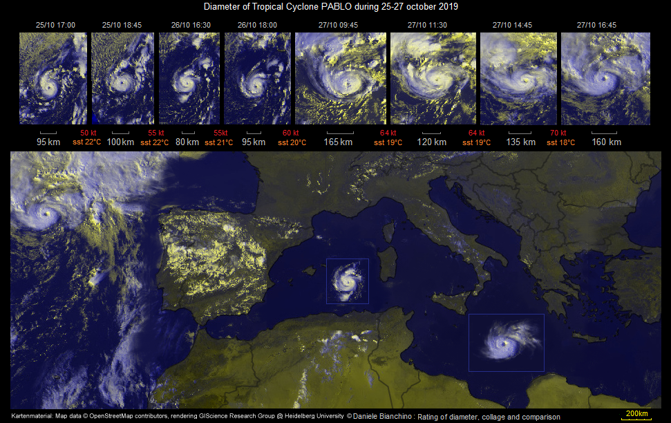
Tropical Storm GRACE (for me a minimal hurricane but no model resolved) in october 2009:
Tropical Storm GRACE (for me a minimal hurricane but no model resolved) in october 2009:
Last edited by DanieleItalyRm on Tue Oct 29, 2019 2:21 pm, edited 2 times in total.
9 likes
-
Vince_and_Grace_fan
- Category 1
- Posts: 323
- Joined: Thu Nov 03, 2016 9:25 am
- Location: Szombathely (Hungary)
Re: ATL: PABLO - Post-Tropical - Discussion
A short satellite animation from Pablo's last 1.5 days:
[youtube]https://youtu.be/TIuKQMf0ENg[/youtube]
[youtube]https://youtu.be/TIuKQMf0ENg[/youtube]
5 likes
Who is online
Users browsing this forum: No registered users and 235 guests