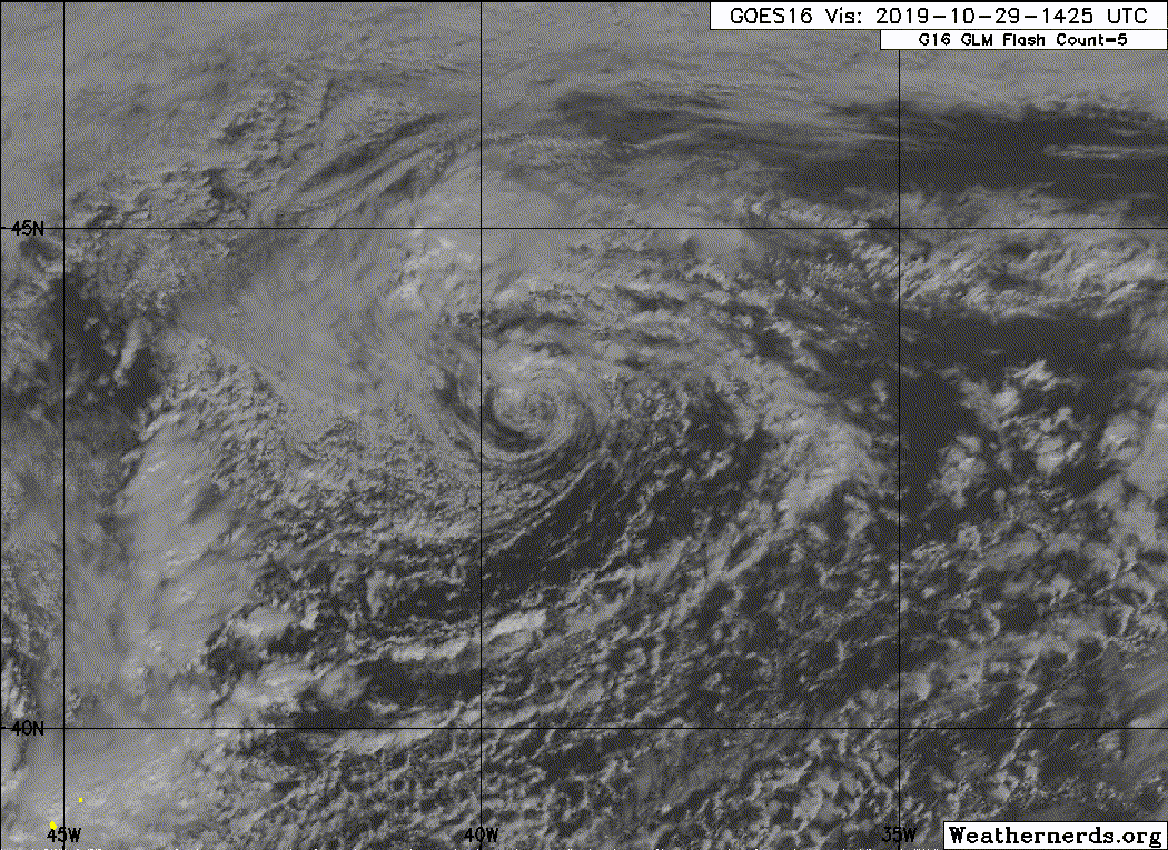
99L INVEST 191028 0600 41.2N 39.5W ATL 65 965
ATL: REBEKAH - Post-Tropical - Discussion
Moderator: S2k Moderators
-
Nancy Smar

- Category 5

- Posts: 1081
- Age: 25
- Joined: Wed Aug 16, 2017 10:03 pm
-
HurricaneRyan
- Category 3

- Posts: 848
- Age: 32
- Joined: Sun Dec 05, 2010 3:05 pm
-
EquusStorm
- Category 5
- Posts: 1649
- Age: 35
- Joined: Thu Nov 07, 2013 1:04 pm
- Location: Jasper, AL
- Contact:
Re: ATL: INVEST 99L - Discussion
You don't see a 65kt/965mb Invest very often, lol.
Super impressive looking all day. Would be cool if it transitioned.

Though half the storms this year were pitiful, one more named storm would tie us with 2017, which is something I doubt anyone seriously expected this year.
Super impressive looking all day. Would be cool if it transitioned.
Though half the storms this year were pitiful, one more named storm would tie us with 2017, which is something I doubt anyone seriously expected this year.
3 likes
Colors of lost purpose on the canvas of irrelevance
Not a meteorologist, in fact more of an idiot than anything. You should probably check with the NHC or a local NWS office for official information.
Not a meteorologist, in fact more of an idiot than anything. You should probably check with the NHC or a local NWS office for official information.
-
EquusStorm
- Category 5
- Posts: 1649
- Age: 35
- Joined: Thu Nov 07, 2013 1:04 pm
- Location: Jasper, AL
- Contact:
Re: ATL: INVEST 99L - Discussion
Looking pretty good this morning...

0 likes
Colors of lost purpose on the canvas of irrelevance
Not a meteorologist, in fact more of an idiot than anything. You should probably check with the NHC or a local NWS office for official information.
Not a meteorologist, in fact more of an idiot than anything. You should probably check with the NHC or a local NWS office for official information.
-
AnnularCane

- S2K Supporter

- Posts: 2965
- Joined: Thu Jun 08, 2006 9:18 am
- Location: Wytheville, VA
-
cycloneye

- Admin

- Posts: 149843
- Age: 69
- Joined: Thu Oct 10, 2002 10:54 am
- Location: San Juan, Puerto Rico
Re: ATL: INVEST 99L - Discussion
Tropical Weather Outlook
NWS National Hurricane Center Miami FL
800 PM EDT Mon Oct 28 2019
For the North Atlantic...Caribbean Sea and the Gulf of Mexico:
1. A large non-tropical low pressure system located several hundred
miles west-northwest of the Azores continues to produce a large
area of gale to hurricane-force winds. The low could gradually
acquire some subtropical characteristics over the next few days
while it moves slowly southward to southeastward over slightly
warmer water. Environmental conditions are expected to become
unfavorable for any further development by Thursday night when
the low is forecast to move back over colder water. For more
information of this system, see High Seas Forecasts issued by
the National Weather Service.
* Formation chance through 48 hours...low...10 percent.
* Formation chance through 5 days...low...20 percent.
High Seas Forecasts issued by the National Weather Service can be
found under AWIPS header NFDHSFAT1, WMO header FZNT01 KWBC, and
online at ocean.weather.gov/shtml/NFDHSFAT1.php.
Forecaster Brown
0 likes
Visit the Caribbean-Central America Weather Thread where you can find at first post web cams,radars
and observations from Caribbean basin members Click Here
and observations from Caribbean basin members Click Here
-
EquusStorm
- Category 5
- Posts: 1649
- Age: 35
- Joined: Thu Nov 07, 2013 1:04 pm
- Location: Jasper, AL
- Contact:
Re: ATL: INVEST 99L - Discussion
Welp... here we go again?
Up to 20/30 but that's probably conservative if this convection holds.

Up to 20/30 but that's probably conservative if this convection holds.
0 likes
Colors of lost purpose on the canvas of irrelevance
Not a meteorologist, in fact more of an idiot than anything. You should probably check with the NHC or a local NWS office for official information.
Not a meteorologist, in fact more of an idiot than anything. You should probably check with the NHC or a local NWS office for official information.
-
HurricaneRyan
- Category 3
- Posts: 848
- Age: 32
- Joined: Sun Dec 05, 2010 3:05 pm
Re: ATL: INVEST 99L - Discussion
I want this to develop, simply to see Rebekah for the very first time.
0 likes
Kay '22 Hilary '23
-
EquusStorm
- Category 5
- Posts: 1649
- Age: 35
- Joined: Thu Nov 07, 2013 1:04 pm
- Location: Jasper, AL
- Contact:
Re: ATL: INVEST 99L - Discussion
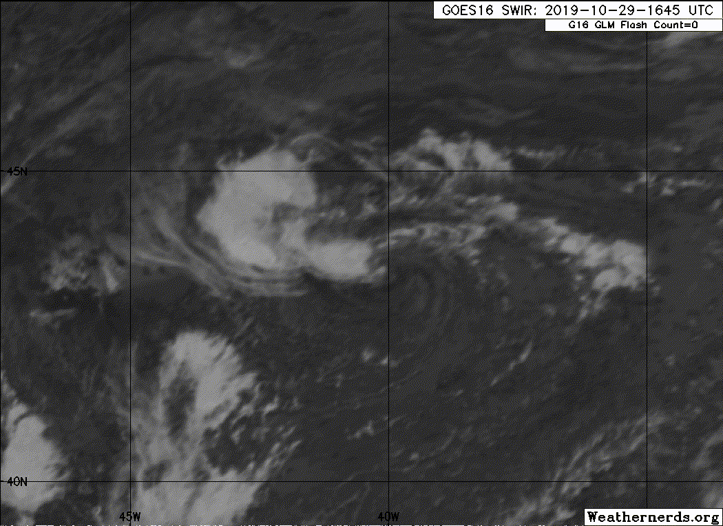
Convection has died off this morning, but still a couple of days left to transition.
0 likes
Colors of lost purpose on the canvas of irrelevance
Not a meteorologist, in fact more of an idiot than anything. You should probably check with the NHC or a local NWS office for official information.
Not a meteorologist, in fact more of an idiot than anything. You should probably check with the NHC or a local NWS office for official information.
-
HurricaneEnzo

- Category 2

- Posts: 744
- Joined: Wed Mar 14, 2018 12:18 pm
- Location: Newport, NC (Hurricane Alley)
Re: ATL: INVEST 99L - Discussion
It was trying to wrap some convection around the center earlier but just couldn't get it done. I don't think this is gonna pull a Pablo but I guess it still has time.
0 likes
Bertha 96' - Fran 96' - Bonnie 98' - Dennis 99' - Floyd 99' - Isabel 03' - Alex 04' - Ophelia 05' - Irene 11' - Arthur 14' - Matthew 16' - Florence 18' - Dorian 19' - Isaias 20' (countless other tropical storms and Hurricane swipes)
I am not a Professional Met just an enthusiast. Get your weather forecasts from the Pros!
I am not a Professional Met just an enthusiast. Get your weather forecasts from the Pros!
-
Sciencerocks
- Category 5
- Posts: 10194
- Age: 40
- Joined: Thu Jul 06, 2017 1:51 am
-
Monsoonjr99
- Tropical Storm

- Posts: 210
- Age: 26
- Joined: Fri Sep 21, 2018 11:22 pm
- Location: Inland Empire, SoCal
Re: ATL: INVEST 99L - Discussion
Even further north than where Pablo formed. It makes sense that this is struggling over ice cold SSTs. It is impressive that this is even trying though; instability must be quite high up there this year.
0 likes
The posts in this forum are NOT official forecasts and should not be used as such. They are just the opinion of the poster and may or may not be backed by sound meteorological data. They are NOT endorsed by any professional institution or STORM2K. For official information, please refer to products from the NHC and NWS.
Some Californian who codes things and tracks weather.
Kay '22, Hilary '23
-
Sciencerocks
- Category 5
- Posts: 10194
- Age: 40
- Joined: Thu Jul 06, 2017 1:51 am
Re: ATL: INVEST 99L - Discussion
I got to say that a solid case could be made for subtropical storm.
0 likes
-
tolakram
- Admin
- Posts: 20189
- Age: 62
- Joined: Sun Aug 27, 2006 8:23 pm
- Location: Florence, KY (name is Mark)
Re: ATL: INVEST 99L - Discussion
Not a lot of convection, and nothing sustained for a very long time in my opinion.
3 likes
M a r k
- - - - -
Join us in chat: Storm2K Chatroom Invite. Android and IOS apps also available.
The posts in this forum are NOT official forecasts and should not be used as such. Posts are NOT endorsed by any professional institution or STORM2K.org. For official information and forecasts, please refer to NHC and NWS products.
-
northjaxpro

- S2K Supporter
- Posts: 8900
- Joined: Mon Sep 27, 2010 11:21 am
- Location: Jacksonville, FL
Re: ATL: INVEST 99L - Discussion
Invest 99L is looking a bit better late this evening as some convection is beginning to pop again around the LLC as the system is drifting to the southwest currently into a bit warmer sea surface temperatures. It looks appreciably better on IR imagery late this evening. There is about a 36 hour window for 99L to possibly transition into one more potential named system before we close out October, more likely in this case into a subtropical cyclone as it drifts a bit farther southward during the next 24 hours.
I called for 5 named storms to develop in the North Atlantic basin this month and it may happen. It will be close...
I called for 5 named storms to develop in the North Atlantic basin this month and it may happen. It will be close...
0 likes
NEVER, EVER SAY NEVER in the tropics and weather in general, and most importantly, with life itself!!
________________________________________________________________________________________
Fay 2008 Beryl 2012 Debby 2012 Colin 2016 Hermine 2016 Julia 2016 Matthew 2016 Irma 2017 Dorian 2019
________________________________________________________________________________________
Fay 2008 Beryl 2012 Debby 2012 Colin 2016 Hermine 2016 Julia 2016 Matthew 2016 Irma 2017 Dorian 2019
-
TallyTracker
- Category 2
- Posts: 787
- Joined: Thu Oct 11, 2018 2:46 pm
Re: ATL: INVEST 99L - Discussion
If the current convection can sustain itself, I see no reason why this couldn’t be classified as STS Rebekah by 5 pm. Maybe 11 am, but my guess the NHC would want to see the convection sustained for at least 12 hours before pulling the trigger.
0 likes
Fran '96, Georges '98, Gordon '00, Gabrielle '01, Charley '04, Frances '04, Jeanne '04, Barry '07, Fay '08, Debby '12, Matthew '16, Emily '17, Irma '17, Michael ‘18, Elsa ‘21, Fred ‘21, Mindy ‘21, Nicole ‘22, Idalia ‘23, Debby ‘24, Helene ‘24
-
tolakram
- Admin
- Posts: 20189
- Age: 62
- Joined: Sun Aug 27, 2006 8:23 pm
- Location: Florence, KY (name is Mark)
Re: ATL: INVEST 99L - Discussion
0 likes
M a r k
- - - - -
Join us in chat: Storm2K Chatroom Invite. Android and IOS apps also available.
The posts in this forum are NOT official forecasts and should not be used as such. Posts are NOT endorsed by any professional institution or STORM2K.org. For official information and forecasts, please refer to NHC and NWS products.
- - - - -
Join us in chat: Storm2K Chatroom Invite. Android and IOS apps also available.
The posts in this forum are NOT official forecasts and should not be used as such. Posts are NOT endorsed by any professional institution or STORM2K.org. For official information and forecasts, please refer to NHC and NWS products.
-
tolakram
- Admin
- Posts: 20189
- Age: 62
- Joined: Sun Aug 27, 2006 8:23 pm
- Location: Florence, KY (name is Mark)
Re: ATL: INVEST 99L - Discussion
Might be making a run at fully tropical. A much different look than yesterday.

1 likes
M a r k
- - - - -
Join us in chat: Storm2K Chatroom Invite. Android and IOS apps also available.
The posts in this forum are NOT official forecasts and should not be used as such. Posts are NOT endorsed by any professional institution or STORM2K.org. For official information and forecasts, please refer to NHC and NWS products.
- - - - -
Join us in chat: Storm2K Chatroom Invite. Android and IOS apps also available.
The posts in this forum are NOT official forecasts and should not be used as such. Posts are NOT endorsed by any professional institution or STORM2K.org. For official information and forecasts, please refer to NHC and NWS products.
-
tolakram
- Admin
- Posts: 20189
- Age: 62
- Joined: Sun Aug 27, 2006 8:23 pm
- Location: Florence, KY (name is Mark)
Re: ATL: INVEST 99L - Discussion
ZCZC MIATWOAT ALL
TTAA00 KNHC DDHHMM
Tropical Weather Outlook
NWS National Hurricane Center Miami FL
800 AM EDT Wed Oct 30 2019
For the North Atlantic...Caribbean Sea and the Gulf of Mexico:
1. Shower activity associated with a non-tropical low pressure system
located several hundred miles west of the westernmost Azores has
become better organized this morning. Some additional development is
possible and it could become a short-lived subtropical cyclone later
today or tonight. The system will likely move over colder waters on
Thursday and further development is unlikely after that time. The
low is producing gale-force winds and these winds are forecast to
continue today, regardless of development. For more information on
this system, see High Seas Forecasts issued by the National Weather
Service.
* Formation chance through 48 hours...medium...50 percent.
* Formation chance through 5 days...medium...50 percent.
High Seas Forecasts issued by the National Weather Service can be
found under AWIPS header NFDHSFAT1, WMO header FZNT01 KWBC, and
online at ocean.weather.gov/shtml/NFDHSFAT1.php.
Forecaster Zelinsky
0 likes
M a r k
- - - - -
Join us in chat: Storm2K Chatroom Invite. Android and IOS apps also available.
The posts in this forum are NOT official forecasts and should not be used as such. Posts are NOT endorsed by any professional institution or STORM2K.org. For official information and forecasts, please refer to NHC and NWS products.
- - - - -
Join us in chat: Storm2K Chatroom Invite. Android and IOS apps also available.
The posts in this forum are NOT official forecasts and should not be used as such. Posts are NOT endorsed by any professional institution or STORM2K.org. For official information and forecasts, please refer to NHC and NWS products.
-
wxman57

- Moderator-Pro Met

- Posts: 23178
- Age: 68
- Joined: Sat Jun 21, 2003 8:06 pm
- Location: Houston, TX (southwest)
Re: ATL: INVEST 99L - Discussion
I'm updating my seasonal forecast to about 55 named storms (by the end of winter) if every occluded low develops convection near the center and is named... 
Pablo and this storm-to-be remind me of the Perfect storm of 1991 that occurred around this time of year.
Pablo and this storm-to-be remind me of the Perfect storm of 1991 that occurred around this time of year.
6 likes
Who is online
Users browsing this forum: No registered users and 31 guests