
WPAC: KALMAEGI - Post-Tropical
Moderator: S2k Moderators
-
NewbieAboutcyclones
- Tropical Low

- Posts: 18
- Age: 31
- Joined: Sun May 21, 2017 2:11 am

-
doomhaMwx

- Category 5

- Posts: 2487
- Age: 27
- Joined: Tue Apr 18, 2017 4:01 am
- Location: Baguio/Benguet, Philippines
- Contact:
Re: WPAC: KALMAEGI - Tropical Storm
Might be a near hit/miss for the northeastern tip of Cagayan. Very rapid weakening when it moves into or briefly enters the Luzon Strait.


0 likes

Re: WPAC: KALMAEGI - Tropical Storm

WDPN32 PGTW 171500
MSGID/GENADMIN/JOINT TYPHOON WRNCEN PEARL HARBOR HI//
SUBJ/PROGNOSTIC REASONING FOR TROPICAL STORM 27W (KALMAEGI)
WARNING NR 020//
RMKS/
1. FOR METEOROLOGISTS.
2. 6 HOUR SUMMARY AND ANALYSIS.
TROPICAL STORM (TS) 27W (KALMAEGI), LOCATED APPROXIMATELY 245 NM
NORTHEAST OF MANILA, PHILIPPINES, HAS TRACKED NORTHWESTWARD AT 05
KNOTS OVER THE PAST SIX HOURS. TS 27W HAS CONTINUED TO TRACK SLOWLY
POLEWARD AFTER A PROLONGED PERIOD OF QUASI-STATIONARY MOTION.
ANIMATED ENHANCED INFRARED SATELLITE IMAGERY DEPICTS A CONSOLIDATING
LOW-LEVEL CIRCULATION WITH IMPROVED BANDING WRAPPING TIGHTLY INTO A
DEFINED LOW-LEVEL CIRCULATION CENTER. A 171017Z SSMIS
37GHZ IMAGE REVEALS TIGHTLY CURVED BANDING WRAPPING INTO A WELL-
DEFINED MICROWAVE EYE FEATURE, WHICH SUPPORTS THE INITIAL POSITION
WITH GOOD CONFIDENCE. THE INITIAL INTENSITY IS ASSESSED AT 55 KNOTS
BASED ON THE MICROWAVE EYE FEATURE AND A PGTW DVORAK INTENSITY
ESTIMATE OF T3.5 (55 KNOTS). A 170935Z SMAP IMAGE INDICATES MAXIMUM
WINDS OF 44 KNOTS (1-MINUTE) SUGGESTING THE INTENSITY COULD BE
SLIGHTLY LOWER. UPPER-LEVEL ANALYSIS INDICATES A FAVORABLE
ENVIRONMENT WITH LOW (05-10 KNOTS) VERTICAL WIND SHEAR AND
NEAR-RADIAL OUTFLOW, ENHANCED BY STRONG SOUTHWESTERLY FLOW TO THE
NORTH. SST VALUES ARE CONDUCIVE FOR FURTHER DEVELOPMENT AT 28-29C.
TS 27W IS TRACKING ALONG THE WESTERN PERIPHERY OF THE LOW- TO MID-
LEVEL SUBTROPICAL RIDGE (STR) POSITIONED TO THE EAST.
3. FORECAST REASONING.
A. THERE IS NO SIGNIFICANT CHANGE TO THE FORECAST PHILOSOPHY FROM
THE PREVIOUS PROGNOSTIC REASONING MESSAGE.
B. TS 27W WILL CONTINUE TRACKING POLEWARD THROUGH TAU 24 TOWARD A
BREAK IN THE STR. THE SYSTEM SHOULD RAPIDLY INTENSIFY BEFORE MAKING
LANDFALL OVER NORTHERN LUZON. AFTER TAU 36, TS 27W WILL WEAKEN
SIGNIFICANTLY DUE TO INCREASED FRICTIONAL EFFECTS AND INCREASING
VWS. NEAR TAU 48, THE SYSTEM WILL TRACK OVER THE SOUTH CHINA SEA
UNDER THE STEERING INFLUENCE OF THE WESTERN STR AND NORTHEAST SURGE
FLOW WITH GRADUAL WEAKENING THROUGH TAU 72.
C. AFTER TAU 72, TS KALMAEGI WILL TRACK SOUTHWESTWARD AND
DISSIPATE BY TAU 96 UNDER STRONG VERTICAL WIND SHEAR AND DRY AIR
ENTRAINMENT. NUMERICAL MODEL GUIDANCE IS IN FAIR AGREEMENT LENDING
MODERATE CONFIDENCE TO THE JTWC FORECAST TRACK.//
NNNN
0 likes
ヤンデレ女が寝取られるているのを見たい!!!
ECMWF ensemble NWPAC plots: https://ecmwfensnwpac.imgbb.com/
Multimodel NWPAC plots: https://multimodelnwpac.imgbb.com/
GFS Ensemble NWPAC plots (16 & 35 day forecast): https://gefsnwpac.imgbb.com/
Plots updated automatically
ECMWF ensemble NWPAC plots: https://ecmwfensnwpac.imgbb.com/
Multimodel NWPAC plots: https://multimodelnwpac.imgbb.com/
GFS Ensemble NWPAC plots (16 & 35 day forecast): https://gefsnwpac.imgbb.com/
Plots updated automatically
Re: WPAC: KALMAEGI - Tropical Storm
Looks like revised down to 50 knots, from 55
27W KALMAEGI 191117 1200 16.9N 124.5E WPAC 50 996
0 likes
ヤンデレ女が寝取られるているのを見たい!!!
ECMWF ensemble NWPAC plots: https://ecmwfensnwpac.imgbb.com/
Multimodel NWPAC plots: https://multimodelnwpac.imgbb.com/
GFS Ensemble NWPAC plots (16 & 35 day forecast): https://gefsnwpac.imgbb.com/
Plots updated automatically
ECMWF ensemble NWPAC plots: https://ecmwfensnwpac.imgbb.com/
Multimodel NWPAC plots: https://multimodelnwpac.imgbb.com/
GFS Ensemble NWPAC plots (16 & 35 day forecast): https://gefsnwpac.imgbb.com/
Plots updated automatically
-
mrbagyo

- Category 5
- Posts: 3963
- Age: 33
- Joined: Thu Apr 12, 2012 9:18 am
- Location: 14.13N 120.98E
- Contact:
Re: WPAC: KALMAEGI - Tropical Storm
bullseye pass

0 likes
The posts in this forum are NOT official forecast and should not be used as such. They are just the opinion of the poster and may or may not be backed by sound meteorological data. They are NOT endorsed by any professional institution or storm2k.org. For official information, please refer to RSMC, NHC and NWS products.

Re: WPAC: KALMAEGI - Tropical Storm
I highly doubt Kalmaegi will reach typhoon status if it retains such shallow and ragged convection.
0 likes
Irene '11 Sandy '12 Hermine '16 5/15/2018 Derecho Fay '20 Isaias '20 Elsa '21 Henri '21 Ida '21
I am only a meteorology enthusiast who knows a decent amount about tropical cyclones. Look to the professional mets, the NHC, or your local weather office for the best information.
I am only a meteorology enthusiast who knows a decent amount about tropical cyclones. Look to the professional mets, the NHC, or your local weather office for the best information.
-
1900hurricane

- Category 5
- Posts: 6063
- Age: 34
- Joined: Fri Feb 06, 2015 12:04 pm
- Location: Houston, TX
- Contact:
Re: WPAC: KALMAEGI - Tropical Storm
I think entraining some of the continental airmass associated with the NE monsoon is limiting it right now, as it has for most of its existence.
0 likes
Contract Meteorologist. TAMU & MSST. Fiercely authentic, one of a kind. We are all given free will, so choose a life meant to be lived. We are the Masters of our own Stories.
Opinions expressed are mine alone.
Follow me on Twitter at @1900hurricane : Read blogs at https://1900hurricane.wordpress.com/
Opinions expressed are mine alone.
Follow me on Twitter at @1900hurricane : Read blogs at https://1900hurricane.wordpress.com/
Re: WPAC: KALMAEGI - Tropical Storm
27W KALMAEGI 191118 0000 17.5N 123.4E WPAC 60 985
TS 1926 (Kalmaegi)
Issued at 00:45 UTC, 18 November 2019
<Analysis at 00 UTC, 18 November>
Scale -
Intensity -
Center position N17°35' (17.6°)
E123°30' (123.5°)
Direction and speed of movement NW Slow
Central pressure 996 hPa
Maximum wind speed near center 23 m/s (45 kt)
Maximum wind gust speed 35 m/s (65 kt)
≥ 30 kt wind area NE 330 km (180 NM)
SW 220 km (120 NM)
0 likes
ヤンデレ女が寝取られるているのを見たい!!!
ECMWF ensemble NWPAC plots: https://ecmwfensnwpac.imgbb.com/
Multimodel NWPAC plots: https://multimodelnwpac.imgbb.com/
GFS Ensemble NWPAC plots (16 & 35 day forecast): https://gefsnwpac.imgbb.com/
Plots updated automatically
ECMWF ensemble NWPAC plots: https://ecmwfensnwpac.imgbb.com/
Multimodel NWPAC plots: https://multimodelnwpac.imgbb.com/
GFS Ensemble NWPAC plots (16 & 35 day forecast): https://gefsnwpac.imgbb.com/
Plots updated automatically
-
1900hurricane
- Category 5
- Posts: 6063
- Age: 34
- Joined: Fri Feb 06, 2015 12:04 pm
- Location: Houston, TX
- Contact:
Re: WPAC: KALMAEGI - Tropical Storm
Looks like its finally doing a decent job at mixing the dry air out.

https://twitter.com/1900hurricane/status/1196249463498661888
https://twitter.com/1900hurricane/status/1196249463498661888
0 likes
Contract Meteorologist. TAMU & MSST. Fiercely authentic, one of a kind. We are all given free will, so choose a life meant to be lived. We are the Masters of our own Stories.
Opinions expressed are mine alone.
Follow me on Twitter at @1900hurricane : Read blogs at https://1900hurricane.wordpress.com/
Opinions expressed are mine alone.
Follow me on Twitter at @1900hurricane : Read blogs at https://1900hurricane.wordpress.com/
-
1900hurricane
- Category 5
- Posts: 6063
- Age: 34
- Joined: Fri Feb 06, 2015 12:04 pm
- Location: Houston, TX
- Contact:
Re: WPAC: KALMAEGI - Tropical Storm
Looks like a nascent eye (click for looping video).
https://twitter.com/1900hurricane/status/1196280689370505216
https://twitter.com/1900hurricane/status/1196280689370505216
1 likes
Contract Meteorologist. TAMU & MSST. Fiercely authentic, one of a kind. We are all given free will, so choose a life meant to be lived. We are the Masters of our own Stories.
Opinions expressed are mine alone.
Follow me on Twitter at @1900hurricane : Read blogs at https://1900hurricane.wordpress.com/
Opinions expressed are mine alone.
Follow me on Twitter at @1900hurricane : Read blogs at https://1900hurricane.wordpress.com/
Re: WPAC: KALMAEGI - Severe Tropical Storm
27W KALMAEGI 191118 0600 18.1N 123.2E WPAC 65 987
STS 1926 (Kalmaegi)
Issued at 06:50 UTC, 18 November 2019
<Analysis at 06 UTC, 18 November>
Scale -
Intensity -
Center position N18°00' (18.0°)
E123°10' (123.2°)
Direction and speed of movement NW Slow
Central pressure 990 hPa
Maximum wind speed near center 30 m/s (55 kt)
Maximum wind gust speed 40 m/s (80 kt)
≥ 50 kt wind area ALL 90 km (50 NM)
≥ 30 kt wind area NE 280 km (150 NM)
SW 170 km (90 NM)
0 likes
ヤンデレ女が寝取られるているのを見たい!!!
ECMWF ensemble NWPAC plots: https://ecmwfensnwpac.imgbb.com/
Multimodel NWPAC plots: https://multimodelnwpac.imgbb.com/
GFS Ensemble NWPAC plots (16 & 35 day forecast): https://gefsnwpac.imgbb.com/
Plots updated automatically
ECMWF ensemble NWPAC plots: https://ecmwfensnwpac.imgbb.com/
Multimodel NWPAC plots: https://multimodelnwpac.imgbb.com/
GFS Ensemble NWPAC plots (16 & 35 day forecast): https://gefsnwpac.imgbb.com/
Plots updated automatically
-
doomhaMwx
- Category 5
- Posts: 2487
- Age: 27
- Joined: Tue Apr 18, 2017 4:01 am
- Location: Baguio/Benguet, Philippines
- Contact:
Re: WPAC: KALMAEGI - Severe Tropical Storm
Kalmaegi has now built a pretty impressive inner core. SATCON near 75kts.


CURRENT ESTIMATE
Date (mmddhhmm): 11180447
SATCON: MSLP = 979 hPa MSW = 73 knots
SATCON Member Consensus: 74.0 knots
Pressure -> Wind Using SATCON MSLP: 69 knots
Distance to Outer Closed Isobar Used is 160 nm
Eye Size Correction Used is -6.3 knots Source: MW
Date (mmddhhmm): 11180447
SATCON: MSLP = 979 hPa MSW = 73 knots
SATCON Member Consensus: 74.0 knots
Pressure -> Wind Using SATCON MSLP: 69 knots
Distance to Outer Closed Isobar Used is 160 nm
Eye Size Correction Used is -6.3 knots Source: MW
1 likes
Re: WPAC: KALMAEGI - Severe Tropical Storm
27W KALMAEGI 191118 1200 18.7N 123.0E WPAC 70 970
0 likes
ヤンデレ女が寝取られるているのを見たい!!!
ECMWF ensemble NWPAC plots: https://ecmwfensnwpac.imgbb.com/
Multimodel NWPAC plots: https://multimodelnwpac.imgbb.com/
GFS Ensemble NWPAC plots (16 & 35 day forecast): https://gefsnwpac.imgbb.com/
Plots updated automatically
ECMWF ensemble NWPAC plots: https://ecmwfensnwpac.imgbb.com/
Multimodel NWPAC plots: https://multimodelnwpac.imgbb.com/
GFS Ensemble NWPAC plots (16 & 35 day forecast): https://gefsnwpac.imgbb.com/
Plots updated automatically
-
doomhaMwx
- Category 5
- Posts: 2487
- Age: 27
- Joined: Tue Apr 18, 2017 4:01 am
- Location: Baguio/Benguet, Philippines
- Contact:
Re: WPAC: KALMAEGI - Severe Tropical Storm
Passing off the northeastern tip of Cagayan towards the Luzon Strait.

27W KALMAEGI 191118 1200 18.9N 123.0E WPAC 75 980
0 likes
-
1900hurricane
- Category 5
- Posts: 6063
- Age: 34
- Joined: Fri Feb 06, 2015 12:04 pm
- Location: Houston, TX
- Contact:
Re: WPAC: KALMAEGI - Severe Tropical Storm
We had three recent AMSU passes. Two of them had the same RMW estimate and came very close together in terms of intensity. The RMW used with these two (19 km) was the JTWC RMW from the b-deck (probably due to an incomplete ring in microwave data on these passes), which looks too big to me. The third RMW estimate (37 km) looks a bit more reasonable, and was probably based of off the microwave data itself instead of using the JTWC input. ~65 kt/980 mb still looks like a decent intensity estimate to me right now.
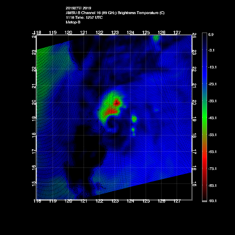
*EDIT: I should add that this is as of about 12Z only.
WP, 27, 201911181059, 30, AMSU, IP, , 1843N, 12295E, , 2, 63, 1, 982, 1, MEAS, , , , , , , , , , , , 37, , W, CIMS, , , , , , , , 982, , NOAA15, , , , , , , , , , , , , , , , , , , ,
WP, 27, 201911181211, 30, AMSU, IP, , 1892N, 12299E, , 2, 73, 1, 972, 1, MEAS, , , , , , , , , , , , 19, , W, CIMS, , , , , , , , 972, , NOAA18, , , , , , , , , , , , , , , , , , , ,
WP, 27, 201911181257, 30, AMSU, IP, , 1901N, 12295E, , 2, 79, 1, 973, 1, MEAS, , , , , , , , , , , , 19, , W, CIMS, , , , , , , , 973, , NOAA90, , , , , , , , , , , , , , , , , , , ,
*EDIT: I should add that this is as of about 12Z only.
Last edited by 1900hurricane on Mon Nov 18, 2019 3:33 pm, edited 1 time in total.
1 likes
Contract Meteorologist. TAMU & MSST. Fiercely authentic, one of a kind. We are all given free will, so choose a life meant to be lived. We are the Masters of our own Stories.
Opinions expressed are mine alone.
Follow me on Twitter at @1900hurricane : Read blogs at https://1900hurricane.wordpress.com/
Opinions expressed are mine alone.
Follow me on Twitter at @1900hurricane : Read blogs at https://1900hurricane.wordpress.com/
Re: WPAC: KALMAEGI - Severe Tropical Storm
STS 1926 (Kalmaegi)
Issued at 18:40 UTC, 18 November 2019
<Analysis at 18 UTC, 18 November>
Scale -
Intensity -
Center position N19°10' (19.2°)
E122°35' (122.6°)
Direction and speed of movement NW 10 km/h (6 kt)
Central pressure 990 hPa
Maximum wind speed near center 30 m/s (55 kt)
Maximum wind gust speed 40 m/s (80 kt)
≥ 50 kt wind area ALL 70 km (40 NM)
≥ 30 kt wind area ALL 170 km (90 NM)
0 likes
ヤンデレ女が寝取られるているのを見たい!!!
ECMWF ensemble NWPAC plots: https://ecmwfensnwpac.imgbb.com/
Multimodel NWPAC plots: https://multimodelnwpac.imgbb.com/
GFS Ensemble NWPAC plots (16 & 35 day forecast): https://gefsnwpac.imgbb.com/
Plots updated automatically
ECMWF ensemble NWPAC plots: https://ecmwfensnwpac.imgbb.com/
Multimodel NWPAC plots: https://multimodelnwpac.imgbb.com/
GFS Ensemble NWPAC plots (16 & 35 day forecast): https://gefsnwpac.imgbb.com/
Plots updated automatically
Re: WPAC: KALMAEGI - Severe Tropical Storm
27W KALMAEGI 191119 0000 19.0N 122.4E WPAC 80 970
0 likes
ヤンデレ女が寝取られるているのを見たい!!!
ECMWF ensemble NWPAC plots: https://ecmwfensnwpac.imgbb.com/
Multimodel NWPAC plots: https://multimodelnwpac.imgbb.com/
GFS Ensemble NWPAC plots (16 & 35 day forecast): https://gefsnwpac.imgbb.com/
Plots updated automatically
ECMWF ensemble NWPAC plots: https://ecmwfensnwpac.imgbb.com/
Multimodel NWPAC plots: https://multimodelnwpac.imgbb.com/
GFS Ensemble NWPAC plots (16 & 35 day forecast): https://gefsnwpac.imgbb.com/
Plots updated automatically
-
1900hurricane
- Category 5
- Posts: 6063
- Age: 34
- Joined: Fri Feb 06, 2015 12:04 pm
- Location: Houston, TX
- Contact:
Re: WPAC: KALMAEGI - Severe Tropical Storm
I can get behind that estimate.
0 likes
Contract Meteorologist. TAMU & MSST. Fiercely authentic, one of a kind. We are all given free will, so choose a life meant to be lived. We are the Masters of our own Stories.
Opinions expressed are mine alone.
Follow me on Twitter at @1900hurricane : Read blogs at https://1900hurricane.wordpress.com/
Opinions expressed are mine alone.
Follow me on Twitter at @1900hurricane : Read blogs at https://1900hurricane.wordpress.com/
Re: WPAC: KALMAEGI - Severe Tropical Storm
27W KALMAEGI 191119 0600 19.4N 122.6E WPAC 75 974
STS 1926 (Kalmaegi)
Issued at 06:45 UTC, 19 November 2019
<Analysis at 06 UTC, 19 November>
Scale -
Intensity -
Center position N19°25' (19.4°)
E122°30' (122.5°)
Direction and speed of movement Almost stationary
Central pressure 985 hPa
Maximum wind speed near center 30 m/s (60 kt)
Maximum wind gust speed 45 m/s (85 kt)
≥ 50 kt wind area ALL 70 km (40 NM)
≥ 30 kt wind area ALL 170 km (90 NM)
0 likes
ヤンデレ女が寝取られるているのを見たい!!!
ECMWF ensemble NWPAC plots: https://ecmwfensnwpac.imgbb.com/
Multimodel NWPAC plots: https://multimodelnwpac.imgbb.com/
GFS Ensemble NWPAC plots (16 & 35 day forecast): https://gefsnwpac.imgbb.com/
Plots updated automatically
ECMWF ensemble NWPAC plots: https://ecmwfensnwpac.imgbb.com/
Multimodel NWPAC plots: https://multimodelnwpac.imgbb.com/
GFS Ensemble NWPAC plots (16 & 35 day forecast): https://gefsnwpac.imgbb.com/
Plots updated automatically
Who is online
Users browsing this forum: No registered users and 55 guests