Florida Weather
Moderator: S2k Moderators
Forum rules

The posts in this forum are NOT official forecast and should not be used as such. They are just the opinion of the poster and may or may not be backed by sound meteorological data. They are NOT endorsed by any professional institution or STORM2K.
-
StormingB81

- S2K Supporter

- Posts: 5676
- Age: 44
- Joined: Thu Aug 27, 2009 1:45 am
- Location: Rockledge, Florida
Re: Florida Weather
Geez looking at the models and it seems like there’s a block and no cold air at all can move down Florida. Can’t even buy some cool air after the November we had
0 likes
-
northjaxpro

- S2K Supporter
- Posts: 8900
- Joined: Mon Sep 27, 2010 11:21 am
- Location: Jacksonville, FL
Re: Florida Weather
StormingB81 wrote:Geez looking at the models and it seems like there’s a block and no cold air at all can move down Florida. Can’t even buy some cool air after the November we had
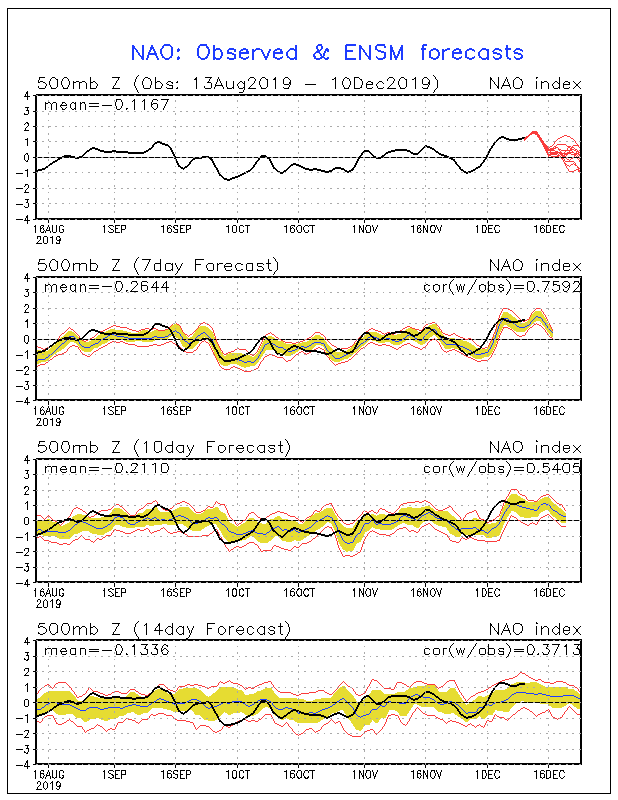
It is that seemingly forever present + NAO. It is the same thing we go through in these parts each and every meteorological winter since 2011. It is just amazing this streak we have been on with this. There is no sign right now that indicates that it is going to get out of this stage either, at least up to Christmas.
 Also, the PNA being negative now is only further keeping any significant cold away from this part of the world.
We are pushing another potential record high for today's date also. It is currently 84.2 degrees on my thermometer here at home. I believe the record temp for today's date is 84 degrees at NWS Jax WFO. So I know we have at least tied the record for today. Just insane for December 10.
We will have a backdoor front push south down the Southeast U.S. coastline on tomorrow to cool us back down to near 70 degrees for max temps tomorrow with an increased onshore flow.
Last edited by northjaxpro on Tue Dec 10, 2019 4:47 pm, edited 2 times in total.
0 likes
NEVER, EVER SAY NEVER in the tropics and weather in general, and most importantly, with life itself!!
________________________________________________________________________________________
Fay 2008 Beryl 2012 Debby 2012 Colin 2016 Hermine 2016 Julia 2016 Matthew 2016 Irma 2017 Dorian 2019
________________________________________________________________________________________
Fay 2008 Beryl 2012 Debby 2012 Colin 2016 Hermine 2016 Julia 2016 Matthew 2016 Irma 2017 Dorian 2019
Re: Florida Weather
There's been close to a 100 degree spread between the warmest parts of FL and the coldest parts of MN today.
0 likes
-
northjaxpro
- S2K Supporter
- Posts: 8900
- Joined: Mon Sep 27, 2010 11:21 am
- Location: Jacksonville, FL
Re: Florida Weather
I just confirmed with the NWS Jax office that today's official high temperature reached 85 degrees, which not only set the new record for today's date, but tied the warmest ever temperature ever recorded for the month of December.
Incredible!
Incredible!
0 likes
NEVER, EVER SAY NEVER in the tropics and weather in general, and most importantly, with life itself!!
________________________________________________________________________________________
Fay 2008 Beryl 2012 Debby 2012 Colin 2016 Hermine 2016 Julia 2016 Matthew 2016 Irma 2017 Dorian 2019
________________________________________________________________________________________
Fay 2008 Beryl 2012 Debby 2012 Colin 2016 Hermine 2016 Julia 2016 Matthew 2016 Irma 2017 Dorian 2019


Re: Florida Weather
As long as the NAO is positive we will not have cold fronts cooling us off which to me is horrible,hopefully the pattern will change in January.
0 likes
-
gatorcane

- S2K Supporter
- Posts: 23708
- Age: 48
- Joined: Sun Mar 13, 2005 3:54 pm
- Location: Boca Raton, FL
Re: Florida Weather
The NAO looks to be going back more towards neutral or even negative in the next couple of weeks. I do think the cold will eventually return. In fact looks like the Euro, CMC, and JMA bring a strong front into Florida around a week from now while the GFS does not.
0 likes
-
northjaxpro
- S2K Supporter
- Posts: 8900
- Joined: Mon Sep 27, 2010 11:21 am
- Location: Jacksonville, FL
Re: Florida Weather
0 likes
NEVER, EVER SAY NEVER in the tropics and weather in general, and most importantly, with life itself!!
________________________________________________________________________________________
Fay 2008 Beryl 2012 Debby 2012 Colin 2016 Hermine 2016 Julia 2016 Matthew 2016 Irma 2017 Dorian 2019
________________________________________________________________________________________
Fay 2008 Beryl 2012 Debby 2012 Colin 2016 Hermine 2016 Julia 2016 Matthew 2016 Irma 2017 Dorian 2019
-
northjaxpro
- S2K Supporter
- Posts: 8900
- Joined: Mon Sep 27, 2010 11:21 am
- Location: Jacksonville, FL
Re: Florida Weather
What a difference a day makes. This time yesterday, we were in the lower 80s, and eventually tied the all-time record max temperature at the NWS Jax WFO (85 degrees) for the month of December yesterday afternoon. Currently, it is 55.2 degrees here at my home station, as we had a cold front move through the area just before 5 a.m. earlier this morning. We have a temperature difference of nearly 30 degrees from this time yesterday. That is a HUGE change from yesterday for sure!! Right now, we have a strong north to northwest flow today, but will become more onshore flow later tonight affecting the area , courtesy of the strong Polar HP (1034 mb ) currently over the Ohio Valley, which will move eastward to New England during the next 24 hours. Temps will stay about where they are now for the rest of the day with the cool NW flow and overcast conditions.
Rain chances will continue to increase beginning on Thursday afternoon and substantially increase to very likely across the region during the day Friday as a Low Pressure area develops and moves out of the GOM and across the area during Friday.
Rain chances will continue to increase beginning on Thursday afternoon and substantially increase to very likely across the region during the day Friday as a Low Pressure area develops and moves out of the GOM and across the area during Friday.
0 likes
NEVER, EVER SAY NEVER in the tropics and weather in general, and most importantly, with life itself!!
________________________________________________________________________________________
Fay 2008 Beryl 2012 Debby 2012 Colin 2016 Hermine 2016 Julia 2016 Matthew 2016 Irma 2017 Dorian 2019
________________________________________________________________________________________
Fay 2008 Beryl 2012 Debby 2012 Colin 2016 Hermine 2016 Julia 2016 Matthew 2016 Irma 2017 Dorian 2019
Re: Florida Weather
There are thunderstorm build-ups just to the west of the metro areas, just like summer. You don't see this happening in mid-December that often. It was way muggy out today, too.
Looking at the radar, it appears that I might actually get grazed by one of them in a few minutes.
Looking at the radar, it appears that I might actually get grazed by one of them in a few minutes.
0 likes
Re: Florida Weather
The 6-10 day has tilted normal to a touch below for the first time in a good while...lending credence to a cooldown of consequence in about a week or so
0 likes
-
gatorcane
- S2K Supporter
- Posts: 23708
- Age: 48
- Joined: Sun Mar 13, 2005 3:54 pm
- Location: Boca Raton, FL
Re: Florida Weather
The ECMWF insists some colder weather is on the way, the GFS not so much:
0 likes

Re: Florida Weather
Euro and GFS are coming together with a consensus for the middle of next week's forecasted temps, the Euro trending warmer while the GFS is trending cooler.


0 likes
Re: Florida Weather
We've had intermittent heavy squalls coming through since last night. Very interesting weather for mid December.....saw a tiny bit of red on the radar last night and it passed overhead. Got pretty wild for a couple minutes. PWat at 2.00 inches so we have a lot to work with.
0 likes
-
northjaxpro
- S2K Supporter
- Posts: 8900
- Joined: Mon Sep 27, 2010 11:21 am
- Location: Jacksonville, FL
Re: Florida Weather
Just checked the daily GEFS teleconnections forecasts and it is beginning to look promising for colder weather in our corner of the world from at or just after Christmas. The PNA is forecast to go positive by December 24 and the NAO is being shown to become negative beginning Christmas Eve.
So, if this trend continues and the + PNA and-NAO alignment verifies, we could finally be seeing some potential big cold spells by the time we approach New Year's Day or at that particular time.
However, this could still change of course, so I am in the see it to believe it mind frame on this for the current time....
0 likes
NEVER, EVER SAY NEVER in the tropics and weather in general, and most importantly, with life itself!!
________________________________________________________________________________________
Fay 2008 Beryl 2012 Debby 2012 Colin 2016 Hermine 2016 Julia 2016 Matthew 2016 Irma 2017 Dorian 2019
________________________________________________________________________________________
Fay 2008 Beryl 2012 Debby 2012 Colin 2016 Hermine 2016 Julia 2016 Matthew 2016 Irma 2017 Dorian 2019
-
gatorcane
- S2K Supporter
- Posts: 23708
- Age: 48
- Joined: Sun Mar 13, 2005 3:54 pm
- Location: Boca Raton, FL
Re: Florida Weather
The GFS has trended colder for next week’s front for the last 5 runs at least it looks like including the 18Z that just ran. Kudos to the Euro which got the idea of a strong front much sooner than the GFS.
0 likes
Re: Florida Weather
gatorcane wrote:The GFS has trended colder for next week’s front for the last 5 runs at least it looks like including the 18Z that just ran. Kudos to the Euro which got the idea of a strong front much sooner than the GFS.
But the Euro was way too strong & too fast with the cold front. It continues to trend warmer for central and southern FL.
Now the Euro is warmer than the GFS for lows Thursday morning.

0 likes
-
northjaxpro
- S2K Supporter
- Posts: 8900
- Joined: Mon Sep 27, 2010 11:21 am
- Location: Jacksonville, FL
Re: Florida Weather
Today's GEFS daily teleconnections update : Currently, PNA is turning positive briefly next week, and a pretty strong PNA spike December 17-19. However, the PNA is forecast to go negative after December 20 and stay that way through Christmas.
However, The NAO is forecast to become negative Dec. 17, and is forecast to stay negative potentially up to New Year's Day.

The next upcoming upper trough forecast for the Eastern CONUS for next week will take shape, and with the PNA forecast to be positive briefly, and the NAO turning negative, could see a freeze to North and Northeast Florida by Thursday morning (Dec. 19). So, if the NAO starts tanking as it is forecast currently, colder times potentially are in store for the Florida peninsula as we approach Christmas and New Year's Day..
Follow along daily with the GEFS. I always do, especially this time of the year....
However, The NAO is forecast to become negative Dec. 17, and is forecast to stay negative potentially up to New Year's Day.
The next upcoming upper trough forecast for the Eastern CONUS for next week will take shape, and with the PNA forecast to be positive briefly, and the NAO turning negative, could see a freeze to North and Northeast Florida by Thursday morning (Dec. 19). So, if the NAO starts tanking as it is forecast currently, colder times potentially are in store for the Florida peninsula as we approach Christmas and New Year's Day..
Follow along daily with the GEFS. I always do, especially this time of the year....
0 likes
NEVER, EVER SAY NEVER in the tropics and weather in general, and most importantly, with life itself!!
________________________________________________________________________________________
Fay 2008 Beryl 2012 Debby 2012 Colin 2016 Hermine 2016 Julia 2016 Matthew 2016 Irma 2017 Dorian 2019
________________________________________________________________________________________
Fay 2008 Beryl 2012 Debby 2012 Colin 2016 Hermine 2016 Julia 2016 Matthew 2016 Irma 2017 Dorian 2019
-
gatorcane
- S2K Supporter
- Posts: 23708
- Age: 48
- Joined: Sun Mar 13, 2005 3:54 pm
- Location: Boca Raton, FL
Re: Florida Weather
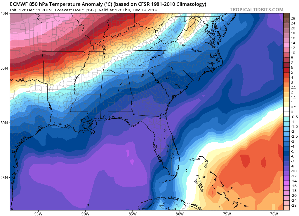
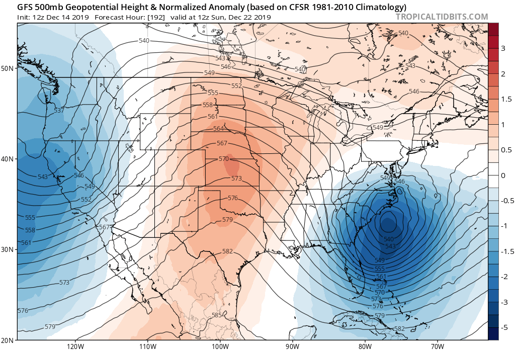
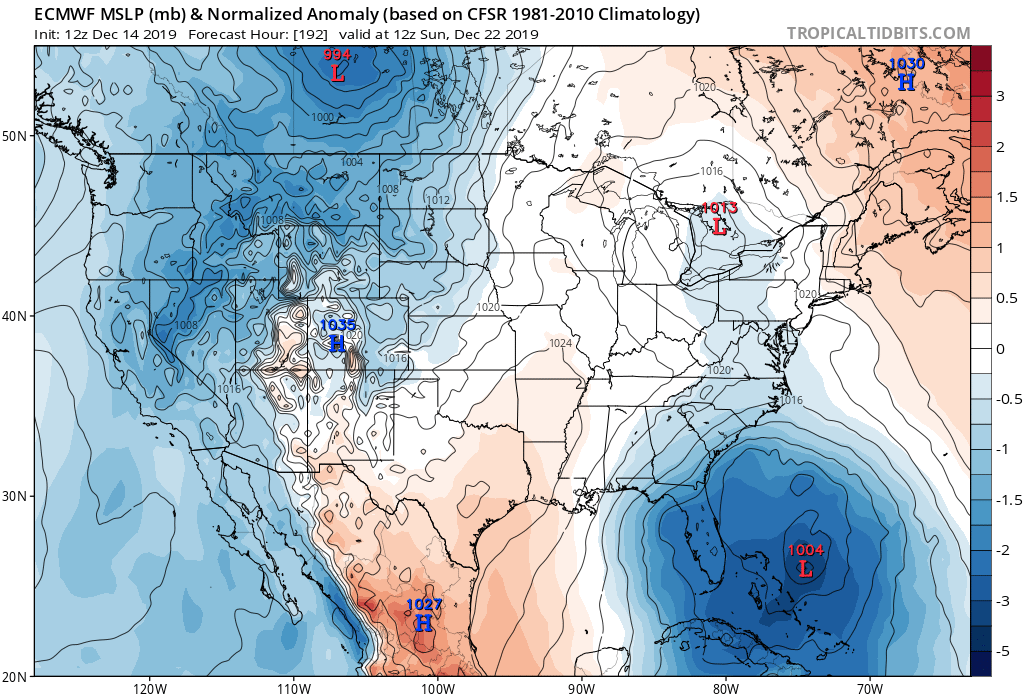
Interesting 500MB low with associated surface low as shown by the GFS (500MB graphic) and Euro (850mb MSLP anomaly graphic). Could me some interesting weather for the peninsula and would bring quite a chill as well with NNW to N wind flow:
0 likes
-
TheStormExpert
Re: Florida Weather
gatorcane wrote:Interesting 500MB low with associated surface low as shown by the GFS (500MB graphic) and Euro (850mb MSLP anomaly graphic). Could me some interesting weather for the peninsula and would bring quite a chill as well with NNW to N wind flow:
https://i.postimg.cc/02k0ZvXK/gfs-z500a-Norm-us-33.png
https://i.postimg.cc/bNnpCXG8/ecmwf-mslpa-Norm-us-9.png
Kind of like what we saw about a month ago. May be the only way at the moment to bring down the chilly stuff to the Florida peninsula.
0 likes
Re: Florida Weather
Looks like a seasonal cool snap is on the way followed by a slow moderation. Longer term shows mild air flooding the field paving the way for normal to a touch above normal conditions. In other words a terrific pattern remains in place with no extremes in either direction. Once we dumped the freak heat of October...we have been cashing in 
0 likes