Florida Weather
Moderator: S2k Moderators
Forum rules

The posts in this forum are NOT official forecast and should not be used as such. They are just the opinion of the poster and may or may not be backed by sound meteorological data. They are NOT endorsed by any professional institution or STORM2K.
-
northjaxpro

- S2K Supporter

- Posts: 8900
- Joined: Mon Sep 27, 2010 11:21 am
- Location: Jacksonville, FL
Re: Florida Weather
Showers and thunderstorms are firing again this afternoon as the strong mid'upper Low , currently in Apalachee.Bay, continues its eastward progression. Showers and storms are moving onshore the Big Bend region and Suwannee River Valley currently, and will overspread the rest of the region into the evening. We have had some unexpected sunshine and daytime heating today within a large dry slot between the Upper Low and the surface Low currently.off the SC coast. We have been since mid morning. Therefore, this should create more instability across North, and even portions of North Central Florida to see the potential of strong storm cells. These cells , with the Upper Low passong right over the area the reast of the afternoon.into the evening, have the potential to bring hail as very cold mid-upper level column of air will be present across the area.
0 likes
NEVER, EVER SAY NEVER in the tropics and weather in general, and most importantly, with life itself!!
________________________________________________________________________________________
Fay 2008 Beryl 2012 Debby 2012 Colin 2016 Hermine 2016 Julia 2016 Matthew 2016 Irma 2017 Dorian 2019
________________________________________________________________________________________
Fay 2008 Beryl 2012 Debby 2012 Colin 2016 Hermine 2016 Julia 2016 Matthew 2016 Irma 2017 Dorian 2019

Re: Florida Weather
NDG wrote::uarrow: SE coastal FL ended up getting a lot more rain than forecasted while the Orlando area a lot less than forecasted.
So true. Yesterday into this morning has been a non-event for the Orlando area and much of Central Fla. Plenty of blue sky breaks today but temps are being held at bay given the dry pocket of drier air wrapping around and into the dry slot. Seems like there's a significant cap above 10K feet. If appears that most inland Central Fla stations are already report south to southwest winds so convergence is rather limited. That said, it appears that some Eastern stations are still showing a primarily northeast to east surface influence and there along the coastline might exist a real possibility of some vertical development to potentially tap into that much colder mid level air overhead. Any storms that break the cap from around the Cape northward toward St. Augustine might really see some impressive lightning and hail. I'd bet on at least a couple of wicked cells just inland and a bit north of Daytona. For most others, probably nothing more then a few hours of stratiform light to moderate rain but with an increased surge in wind gusts. Grab your hot cocoa, at least it'll look a bit like winter for late today, tonight, and into tomm. a.m.
0 likes
Andy D
(For official information, please refer to the NHC and NWS products.)
(For official information, please refer to the NHC and NWS products.)
Re: Florida Weather
psyclone wrote:I can't be the only one itching for a return of the sun. Thankfully we are about to hit a weather jackpot with a great stretch of weather after today.
For me, nothing beats a bright strong sun under temps sitting somewhere in the upper 50's
0 likes
Andy D
(For official information, please refer to the NHC and NWS products.)
(For official information, please refer to the NHC and NWS products.)
-
northjaxpro
- S2K Supporter
- Posts: 8900
- Joined: Mon Sep 27, 2010 11:21 am
- Location: Jacksonville, FL
Re: Florida Weather
chaser1 wrote:NDG wrote::uarrow: SE coastal FL ended up getting a lot more rain than forecasted while the Orlando area a lot less than forecasted.
So true. Yesterday into this morning has been a non-event for the Orlando area and much of Central Fla. Plenty of blue sky breaks today but temps are being held at bay given the dry pocket of drier air wrapping around and into the dry slot. Seems like there's a significant cap above 10K feet. If appears that most inland Central Fla stations are already report south to southwest winds so convergence is rather limited. That said, it appears that some Eastern stations are still showing a primarily northeast to east surface influence and there along the coastline might exist a real possibility of some vertical development to potentially tap into that much colder mid level air overhead. Any storms that break the cap from around the Cape northward toward St. Augustineand NorthnCentral penindula.
might really see some impressive lightning and hail. I'd bet on at least a couple of wicked cells just inland and a bit north of Daytona. For most others, probably nothing more then a few hours of stratiform light to moderate rain but with an increased surge in wind gusts. Grab your hot cocoa, at least it'll look a bit like winter for late today, tonight, and into tomm. a.m.
Yeah, good post Chaser. I think with the added solar heating today, we will see some strong thunderstorms that will produce hail, especially and North Central Florida.
There have been three occasons in this storm system in which we have had prominent dry slots, includng today. As I touched on awhile ago, unfortunately some areas in Central Florida were adversely impacted by these dry slots during this event, and they did not get nearly as much rainfall as the panhandle, and other locales of North and Northeast Florida received. Southeast Florida areas got deluged lsst night, which was discussed earlier. At least you will get some additional rain going into the late afternoon and evening down into Central Florida with the Upper Low moving through the region.
Last edited by northjaxpro on Mon Dec 23, 2019 4:28 pm, edited 3 times in total.
0 likes
NEVER, EVER SAY NEVER in the tropics and weather in general, and most importantly, with life itself!!
________________________________________________________________________________________
Fay 2008 Beryl 2012 Debby 2012 Colin 2016 Hermine 2016 Julia 2016 Matthew 2016 Irma 2017 Dorian 2019
________________________________________________________________________________________
Fay 2008 Beryl 2012 Debby 2012 Colin 2016 Hermine 2016 Julia 2016 Matthew 2016 Irma 2017 Dorian 2019
-
TheStormExpert
Re: Florida Weather
Looks like the trend of above average winters in terms of temperatures will likely continue as the NAO is now longer forecasted to go negative, go figure! I was hoping that the flip to 2020 would also flip the switch but I guess not.
0 likes


Re: Florida Weather
The NAO should go negative in April when at that point it won’t matter any more.
0 likes
-
northjaxpro
- S2K Supporter
- Posts: 8900
- Joined: Mon Sep 27, 2010 11:21 am
- Location: Jacksonville, FL
Re: Florida Weather


0 likes
NEVER, EVER SAY NEVER in the tropics and weather in general, and most importantly, with life itself!!
________________________________________________________________________________________
Fay 2008 Beryl 2012 Debby 2012 Colin 2016 Hermine 2016 Julia 2016 Matthew 2016 Irma 2017 Dorian 2019
________________________________________________________________________________________
Fay 2008 Beryl 2012 Debby 2012 Colin 2016 Hermine 2016 Julia 2016 Matthew 2016 Irma 2017 Dorian 2019
-
TheStormExpert
Re: Florida Weather
boca wrote:The NAO should go negative in April when at that point it won’t matter any more.
Exactly! April-September is when the NAO has gone negative more so than not.
0 likes
-
StormingB81

- S2K Supporter
- Posts: 5676
- Age: 44
- Joined: Thu Aug 27, 2009 1:45 am
- Location: Rockledge, Florida
Re: Florida Weather
You know it's bad when the GFS doesn't even give fake long range cold! Giddyup. I have been working on bringing back our loyal friend the southeast ridge.. 
0 likes
-
FlaWeatherDude
- Tropical Storm

- Posts: 115
- Age: 41
- Joined: Wed Oct 10, 2018 2:57 pm
- Location: Orlando, FL.
Re: Florida Weather
Tomorrow and Christmas Orlando should be dynamite with comfortable humidity with two-three nights below 60 at night. Then onshore flow should bring warmth humidity back til our next front on New Years Eve brings us back to average/slightly below just in time for the ball drop. I don't expect any arctic outbreaks until the Polar Vortex weakens which looks like a good bet mid-late Jan. The NAO/AO/EPO is expected to spike by early Jan which means any trough will be of Pacific origin.

Last edited by FlaWeatherDude on Mon Dec 23, 2019 8:15 pm, edited 2 times in total.
0 likes
"Windy has wings to fly above the clouds".
-
AdamFirst

- S2K Supporter
- Posts: 2490
- Age: 36
- Joined: Thu Aug 14, 2008 10:54 am
- Location: Port Saint Lucie, FL
Re: Florida Weather

Saving that run...for the laughs
0 likes
Dolphins Marlins Canes Golden Panthers HEAT
Andrew 1992 - Irene 1999 - Frances 2004 - Jeanne 2004 - Wilma 2005 - Fay 2008 - Isaac 2012 - Matthew 2016 - Irma 2017 - Dorian 2019 - Ian 2022 - Nicole 2022 - Milton 2024
Andrew 1992 - Irene 1999 - Frances 2004 - Jeanne 2004 - Wilma 2005 - Fay 2008 - Isaac 2012 - Matthew 2016 - Irma 2017 - Dorian 2019 - Ian 2022 - Nicole 2022 - Milton 2024
-
gatorcane

- S2K Supporter
- Posts: 23708
- Age: 48
- Joined: Sun Mar 13, 2005 3:54 pm
- Location: Boca Raton, FL
Re: Florida Weather
psyclone wrote:You know it's bad when the GFS doesn't even give fake long range cold! Giddyup. I have been working on bringing back our loyal friend the southeast ridge..
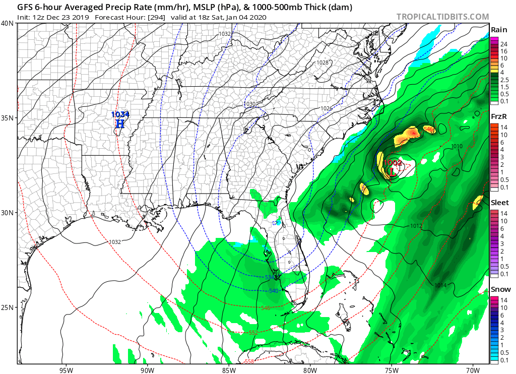
But it is showing cold and some wintry precip too near your neck of the woods. 18Z GFS has it overr Jax as the model bombs another low (bombgenesis) this time just off the SE US coast and Florida.
0 likes
-
northjaxpro
- S2K Supporter
- Posts: 8900
- Joined: Mon Sep 27, 2010 11:21 am
- Location: Jacksonville, FL
Re: Florida Weather
It is nice to dream about such a scenario, which would really be ctazy around this particular area for sure.
I do find it a weird coincidence to see this run come on the 30 year anniversary in which we had snow in Jacksonville this day, Dec.23, and the stayed on the ground a couple of days, and gave us our only White Christnas ever in history. Oh what an amazing weather day it was for me that day, definitely very high on my list of top weather events I experienced in my life and career in this business for sure!!
So, that 1989 event is proof that you never, ever can say NEVER to something like this occuring huh?
1 likes
NEVER, EVER SAY NEVER in the tropics and weather in general, and most importantly, with life itself!!
________________________________________________________________________________________
Fay 2008 Beryl 2012 Debby 2012 Colin 2016 Hermine 2016 Julia 2016 Matthew 2016 Irma 2017 Dorian 2019
________________________________________________________________________________________
Fay 2008 Beryl 2012 Debby 2012 Colin 2016 Hermine 2016 Julia 2016 Matthew 2016 Irma 2017 Dorian 2019
-
northjaxpro
- S2K Supporter
- Posts: 8900
- Joined: Mon Sep 27, 2010 11:21 am
- Location: Jacksonville, FL
Re: Florida Weather
Low Pressure(1006 mb) area off the SC coast this morning, and showers are rotating S/SW down the coast snd just off shore of Northeast Florida. It also is bringing breezy conditions early this morning with northwest wind gusting up to 25 mph at times. I measured an additional 1/4 of an inch with these showers overnight. There were no hail reports from yesterday and last night to my surprise, given the dynamics that were shown by the models being in place with the passage of the mod-upper Low
The Low Pressure area will FINALLY pull away from the region later today and the rain in the area currently will be ending, and should be clearing for good area wide by this evening, just.in time to give us a great weather day for Christmas tomorrow.
This has been an impressive rain producing storm for most in the extreme Southeast U.S, especislly along the Southeast Atlantic Coastal regions. it looks like I will end up with just under 4.5 inches of rainfall at my locale for this four-day event.
Generally, totals ended up ranging from 3-5 inches across North and Northeast Florida and 4-6 inches across Southeast Georgia. Rainfall amounts were even heavier just a bit north up the coast up around Savannah and into Charleston, SC, where there are areas approaching totals ranging from 8 to 10 inches of rainfall. Southeast Florida (Ft. Lauderdale/Boca Raton) had 8 inches of rain in that Sunday evening severe weather event there.
I do want to say to all.of you, Merry Christmas!!!!
1 likes
NEVER, EVER SAY NEVER in the tropics and weather in general, and most importantly, with life itself!!
________________________________________________________________________________________
Fay 2008 Beryl 2012 Debby 2012 Colin 2016 Hermine 2016 Julia 2016 Matthew 2016 Irma 2017 Dorian 2019
________________________________________________________________________________________
Fay 2008 Beryl 2012 Debby 2012 Colin 2016 Hermine 2016 Julia 2016 Matthew 2016 Irma 2017 Dorian 2019
-
StormingB81
- S2K Supporter
- Posts: 5676
- Age: 44
- Joined: Thu Aug 27, 2009 1:45 am
- Location: Rockledge, Florida
Re: Florida Weather
Wel the snow is gone but still showing cold! GFS at least so far isn’t backing down on the cold.
0 likes
-
northjaxpro
- S2K Supporter
- Posts: 8900
- Joined: Mon Sep 27, 2010 11:21 am
- Location: Jacksonville, FL
Re: Florida Weather
BTW , I am sticking steadfast to what the GFS has been showing the past several days to a big cold snap during the first full week of Jaunuary 2020. I admit I am a GFS man, and I love the model, especially during winter season. GFS has paid dividends for me in recent years, and I am counting on it here.
I will eat my crow served well done if I am wrong
Merry Christmas everyone!!!
I will eat my crow served well done if I am wrong
Merry Christmas everyone!!!
0 likes
NEVER, EVER SAY NEVER in the tropics and weather in general, and most importantly, with life itself!!
________________________________________________________________________________________
Fay 2008 Beryl 2012 Debby 2012 Colin 2016 Hermine 2016 Julia 2016 Matthew 2016 Irma 2017 Dorian 2019
________________________________________________________________________________________
Fay 2008 Beryl 2012 Debby 2012 Colin 2016 Hermine 2016 Julia 2016 Matthew 2016 Irma 2017 Dorian 2019
Re: Florida Weather
I hope your right but the NAO will be two deviations in the positive so you might be eating crow.
1 likes
-
northjaxpro
- S2K Supporter
- Posts: 8900
- Joined: Mon Sep 27, 2010 11:21 am
- Location: Jacksonville, FL
Re: Florida Weather
boca wrote:I hope your right but the NAO will be two deviations in the positive so you might be eating crow.
We shall see!! Goìng with my gut instincts with this.
0 likes
NEVER, EVER SAY NEVER in the tropics and weather in general, and most importantly, with life itself!!
________________________________________________________________________________________
Fay 2008 Beryl 2012 Debby 2012 Colin 2016 Hermine 2016 Julia 2016 Matthew 2016 Irma 2017 Dorian 2019
________________________________________________________________________________________
Fay 2008 Beryl 2012 Debby 2012 Colin 2016 Hermine 2016 Julia 2016 Matthew 2016 Irma 2017 Dorian 2019
-
gatorcane
- S2K Supporter
- Posts: 23708
- Age: 48
- Joined: Sun Mar 13, 2005 3:54 pm
- Location: Boca Raton, FL
Re: Florida Weather
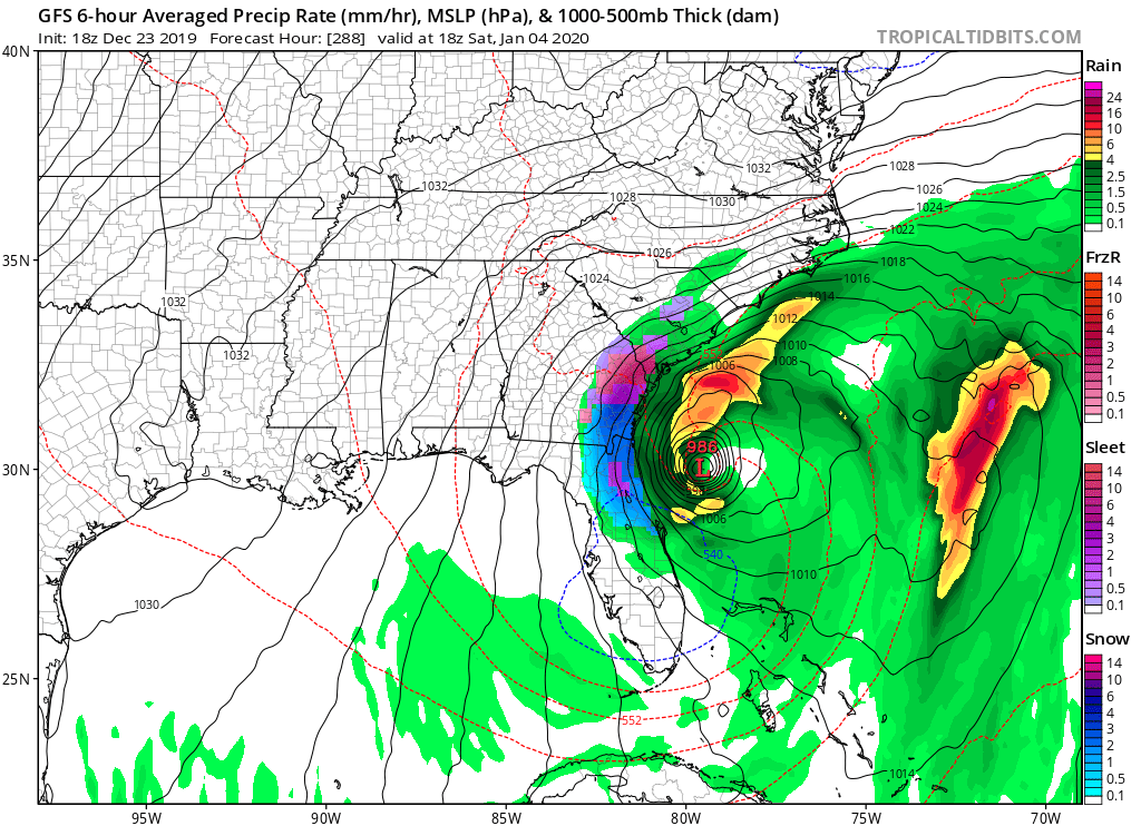
If this comes into the 7 day range on the GFS watch out. For now it is keeping this out in fantasy land:
0 likes