Florida Weather
Moderator: S2k Moderators
Forum rules

The posts in this forum are NOT official forecast and should not be used as such. They are just the opinion of the poster and may or may not be backed by sound meteorological data. They are NOT endorsed by any professional institution or STORM2K.


Re: Florida Weather
SPC has just issued a mesocale disc. 80 % chance of issuance of a Tornado watch for central FL.
0 likes


Re: Florida Weather
MetroMike wrote:SPC has just issued a mesocale disc. 80 % chance of issuance of a Tornado watch for central FL.
Indeed, Tornado watch just issued for most of central Florida until 3 am.
0 likes
Re: Florida Weather
Dumped half an inch of rain on me in maybe 7 minutes, multiple power flickers between 10:15-10:30 (including one 3-5 min outage), and my Acurite picked up a 32 MPH gust (so it was probably far higher given the power flickers & limits of the unit).
Tomorrow morning will be an interesting sight.
Tomorrow morning will be an interesting sight.
0 likes
-
HurricaneBelle

- S2K Supporter

- Posts: 1209
- Joined: Sun Aug 27, 2006 6:12 pm
- Location: Clearwater, FL
Re: Florida Weather
Squall line packing quite a punch through the Tampa Bay area, we had a tornado warning through Pinellas Park over across the Bay to South Tampa, and that cell knocked a crane down over I-275 in St. Pete/Clearwater just south of the Howard Frankland bridge. Now there are multiple tornado warnings south of there in southern Hillsborough near Ruskin and over Manatee county.
WTVT's radar is showing winds of 101-113 MPH with the Manatee County system. Fortunately in North Pinellas we just had some heavy rain and wind gusts but nothing really severe.
WTVT's radar is showing winds of 101-113 MPH with the Manatee County system. Fortunately in North Pinellas we just had some heavy rain and wind gusts but nothing really severe.
0 likes
-
TheStormExpert
Re: Florida Weather
You'd think it was March with this squall line traversing the Florida peninsula tonight. Spring just keeps starting earlier each year!
1 likes
Re: Florida Weather
TheStormExpert wrote:You'd think it was March with this squall line traversing the Florida peninsula tonight. Spring just keeps starting earlier each year!
Actually mid latitude driven squall lines are a feature of typical Florida winters. By spring we're frequently below the fray. Peak SVR season is feb/March....so we should be getting some of this.
0 likes

Re: Florida Weather
Things are going to be warm and boring after last night over the next couple of weeks.

0 likes
Re: Florida Weather
For what its worth , GFS has an entirely different long wave pattern over the next 7-10 days over Florida.
https://www.tropicaltidbits.com/analysis/models/?model=gfs®ion=us&pkg=z500_mslp&runtime=2020020706&fh=252
https://www.tropicaltidbits.com/analysis/models/?model=gfs®ion=us&pkg=z500_mslp&runtime=2020020706&fh=252
0 likes
Re: Florida Weather
Funny, the GFS now looks significantly wetter, especially around the 2/14-2/17 time frame.....interesting.
0 likes

Re: Florida Weather
ronjon wrote:For what its worth , GFS has an entirely different long wave pattern over the next 7-10 days over Florida.
https://www.tropicaltidbits.com/analysis/models/?model=gfs®ion=us&pkg=z500_mslp&runtime=2020020706&fh=252
True but it is the "happy hour" run. Hopefully we'll see some ongoing consistency to suggest merit to this potentially cooler/wetter pattern. Better yet, let's see if the EURO once in range begins to suggest the same
0 likes
Andy D
(For official information, please refer to the NHC and NWS products.)
(For official information, please refer to the NHC and NWS products.)
-
northjaxpro

- S2K Supporter
- Posts: 8900
- Joined: Mon Sep 27, 2010 11:21 am
- Location: Jacksonville, FL
Re: Florida Weather
It was a quick flash in the pan scenario and flutter of electical power with last night's squall line, which moved through the Jax area between 10:30 p.m. and 12 midnight. My power blinked on and off briefly, but did stay on for the duration of the night. The max gust I recorded here at the home locale station was 56 mph, shortly before 11:00 last night. The Low Pressure area that developed in the Southeast U.S., really intensified yesterday into last night, and really triggered those strong southerly winds. The winds during yesterday really were quite impressive, to the point that when the actual squall line did pass through, it did so with lot much of a hell and fury scenario one would have thought, given the dynamics in place. The squall line moved through so rapidly, it barely made much of a dent in rainfall here. I received only about .4 of an inch through all of that.
There were some downed trees due to the strong wind across the region into last night, but no actual reports of tornadoes to have touched down thankfully across Northeast Florida. But, it did make for an interesting day of measuring the wind gusts yesterday and into last night, and seeing the barometric pressures drop steadily throughout the day.
Tonight will be interesting in that we probably will see the best and most ideal radiational cooling conditions as High Pressure will be directly overhead, with a clear sky and very light to calm winds. This also will bring about the formation of frost into tomorrow morning. Dew point temperatures are currently in the mid-upper 20s across the North Florida region, and with optimal cooling tonight, I would not be shocked in the least to see interior areas get down to the 32F freezing mark, or even slightly below that, by sunrise tomorrow morning. This will probably be one of the last good chances of potentially getting to the freeze mark here at my locale this meteorological winter season, the way it has been that is for sure!
This little cool snap will be over by Sunday. This will probably be it for at least the least 7 -10 days, possibly longer, as the 12Z EURO keeps the ever present Southwestern ATL ridge as the dominant feature across the peninsula, of course corresponding to the ever present strong + NAO. GFS and EURO does show a strong Polar HP wedging itself down the Eastern U.S. seaboard by February 12 (Wednesday), which may bring a brief, cooler onshore flow to Northeast Florida mid week, but the 12Z EURO has the ridge re-asserting its influence by the end of next week, moving the front back north through this region as a warm front by Thursday . Otherwise, no true cold air in sight for the Florida peninsula. The - PNA will likely continue the active southern stream jet right on into the next 10-14 days, with significant rain to continue across much of the Lower MS River Valley Region, into the TN Valley region and portions of the Carolinas.
0 likes
NEVER, EVER SAY NEVER in the tropics and weather in general, and most importantly, with life itself!!
________________________________________________________________________________________
Fay 2008 Beryl 2012 Debby 2012 Colin 2016 Hermine 2016 Julia 2016 Matthew 2016 Irma 2017 Dorian 2019
________________________________________________________________________________________
Fay 2008 Beryl 2012 Debby 2012 Colin 2016 Hermine 2016 Julia 2016 Matthew 2016 Irma 2017 Dorian 2019
Re: Florida Weather
A protracted stretch of magnificent weather is just getting underway. We're still at the time of the year where we can run above normal and still be exceptionally nice. a glorious way to run the clock out on winter 
0 likes
-
gatorcane

- S2K Supporter
- Posts: 23708
- Age: 48
- Joined: Sun Mar 13, 2005 3:54 pm
- Location: Boca Raton, FL
Re: Florida Weather
Dew point of 71F and temp of 77F and 82% humidity at 8:00 in the evening at my locale. Feels like late spring/summer evening a bit with the elevated humidity. Looking at the models, it is the same pattern like a broken record we have seen just about the entire winter with an Upper low cuts off out west and digs a trough while a gigantic ridge parks itself over the northern Caribbean, Florida and the Bahamas, no end in sight.
0 likes
-
TheStormExpert
Re: Florida Weather
Lets face it, winter or whatever you want to call it is over down here! Lost track of how many years the +NAO realm has won out during the winter months. Hopefully that -NAO shows up during hurricane season though, don't need anymore hurricane scares like Matthew, Irma, and Dorian here in S.FL.
0 likes
Re: Florida Weather
We've entered that long carefree period beyond the risk of freeze and before the risk hurricanes. Spring provides typically nice weather with longer days making it my favorite shoulder season. It is a tad muggy and plenty warm right now. The slight cooldown for valentines day will be really nice..
1 likes
Re: Florida Weather
Keep an eye on the long range. GFS still trying to push some enjoyable chilly air down the state in the long range.
0 likes
Andy D
(For official information, please refer to the NHC and NWS products.)
(For official information, please refer to the NHC and NWS products.)
-
northjaxpro
- S2K Supporter
- Posts: 8900
- Joined: Mon Sep 27, 2010 11:21 am
- Location: Jacksonville, FL
Re: Florida Weather
chaser1 wrote:Keep an eye on the long range. GFS still trying to push some enjoyable chilly air down the state in the long range.
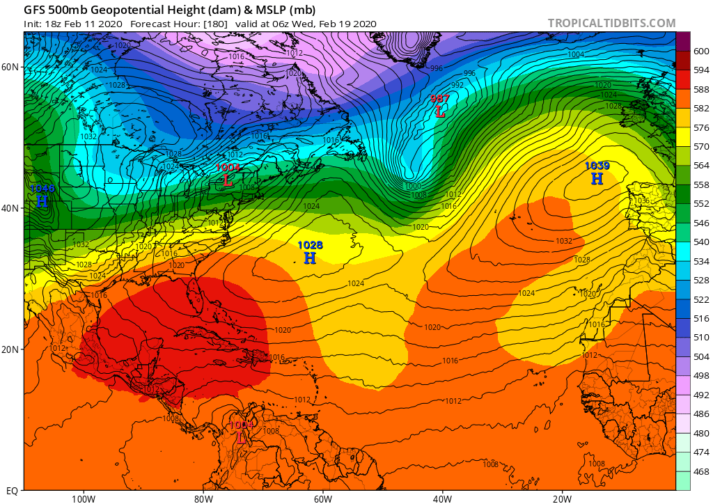
Yeah Chaser I am very cautiously observing the 168 - 192 hour outlook. However, I would not hold my breath much about it though. 06Z GFS wants to bring down a potent 1048 mb Polar High down into the Mid MS Valley region, with a cold front slipping south into Northern Florida peninsula by February 20, in the 7-8 day range. However, the EURO has yet to agree with this. We have yet to see this set-up for most of this warm winter, and the teleconnections don't favor this either with the +NAO, - PNA holding strong, at least through February 21.
Keep an eye on this period, but I would bet on the persistent SW ATL RIDGE to win out, as has been the story seemingly forever around these parts. So, unless the EURO in its future runs sees what the GFS is depicting on the 06Z run this morning , I would be wary with the GFS. It has been very non-trustworthy for me past 7 days and beyond this meteorological so called winter season. We may cool for a couple of days next week over North Florida, but the shield(ridge) will for the most part keep the real cold away from the peninsula through the medium to long range out through at least 10 days from now.
BTW, of particular interest for me, my Japanese plum tree is almost full and ripe with fruit, and here it is just mid-February. Usually, the tree does not begin bearing fruit, let alone ripe plums, until around mid-March at the earliest. We are talking a month to 6 weeks ahead of schedule for the tree. I have never seen it bare plums, let alone nearly ripe ones this early. Yet, another huge indicator of the massive shift to warm winters, even for Northeast Florida. Heck, I am almost tempted to plant the spring garden, something I NEVER even thought about around here until the end of March during most instances, when the threat of freezes in the Jax area usually are done. But, during the past decade, I have noticed I could probably think about planting in the beginning of March, as crazy as that would have been in past years. My oh my, we don't have winter seasons here anymore, much to my dismay. It is just plain fact!
0 likes
NEVER, EVER SAY NEVER in the tropics and weather in general, and most importantly, with life itself!!
________________________________________________________________________________________
Fay 2008 Beryl 2012 Debby 2012 Colin 2016 Hermine 2016 Julia 2016 Matthew 2016 Irma 2017 Dorian 2019
________________________________________________________________________________________
Fay 2008 Beryl 2012 Debby 2012 Colin 2016 Hermine 2016 Julia 2016 Matthew 2016 Irma 2017 Dorian 2019
Re: Florida Weather
This Miami weather right now is really just a notch or two below that of mid-May. East of the Palmetto, there is not even the slightest hint of any kind of chill in the air in the early morning - maybe further out by the far western suburbs and the Everglades there still is?, but not here. I went out walking a little yesterday at lunch, and it was actually touching on sweaty-and-uncomfortable. Early morning, while not "cool" hasn't become sweaty and uncomfortable yet with a dewpoint at 69, at least. If that morning dewpoint notches up a couple more degrees we're basically at summer.
0 likes

Re: Florida Weather
They need to change hurricane season to May 1st instead of June 1st due to global warming.
0 likes
-
northjaxpro
- S2K Supporter
- Posts: 8900
- Joined: Mon Sep 27, 2010 11:21 am
- Location: Jacksonville, FL
Re: Florida Weather
Patrick99 wrote:This Miami weather right now is really just a notch or two below that of mid-May. East of the Palmetto, there is not even the slightest hint of any kind of chill in the air in the early morning - maybe further out by the far western suburbs and the Everglades there still is?, but not here. I went out walking a little yesterday at lunch, and it was actually touching on sweaty-and-uncomfortable. Early morning, while not "cool" hasn't become sweaty and uncomfortable yet with a dewpoint at 69, at least. If that morning dewpoint notches up a couple more degrees we're basically at summer.
I will piggyback on what StormExpert and others have chimed in about the potential adverse consequences of these prolonged periods the + NAO have brought and we have consistently seen every winter this past decade.
Yeah, they have been terrific for those reaping the benefits of warm winters, yeah for sure. However, the real danger indeed lurks when hurricane season comes. These warm winters are also contributing greatly to above average sea surface temperatures in the Gulf of Mexico and off the Southeast U.S. coast. Come May, we could potentially seeing some really abnormal ssts in these areas. We sure better hope that this prolonged, anomalous + NAO will not continue on into the upcoming months. There are other factors which will determine how the hurricane season will shake down, namely the MJO pulse of course, and the anticipared development of an moderate El Nino this upcoming season, though not guaranteed. We have seen how the peninsula has been impacted by major tropical cyclones (Michael) and how dangerously close we have come to being impacted by a few other majors, a weakening Irma in 2017, Matthew (2016) and Dorian last summer, in particular. Yeah, we have been extremely fortunate with escaping cold down here in the past decade with the + NAO. However, it is a double-edged sword. We are seeing our fortunes turning the other way unfortunately with regards to the tropical cyclones.
So, this +NAO could potentially remain a very ominous proposition if it continues down the road. I sure hope we see changes in the pattern which will bring troughs, + PNA or - NAO, to deflect cyclones away from Florida and the Eastern U.S. However, with Dorian, we saw just how extremely lucky we were, with a trough coming in literally at the last possible juncture, to turn it away to save Florida, but too late unfortunately for the NW Bahamas.
Personally, I am feeling even more uneasy about the upcoming hurricane season, and I will leave this talk on the table for later. But, indeed I am very concerned, and I will talk more about this as we get a bit closer to the start of the season, as we get into late April and May.
0 likes
NEVER, EVER SAY NEVER in the tropics and weather in general, and most importantly, with life itself!!
________________________________________________________________________________________
Fay 2008 Beryl 2012 Debby 2012 Colin 2016 Hermine 2016 Julia 2016 Matthew 2016 Irma 2017 Dorian 2019
________________________________________________________________________________________
Fay 2008 Beryl 2012 Debby 2012 Colin 2016 Hermine 2016 Julia 2016 Matthew 2016 Irma 2017 Dorian 2019
Return to “USA & Caribbean Weather”
Who is online
Users browsing this forum: No registered users and 73 guests