90S INVEST 200221 0600 12.7S 118.1E SHEM 15 1008
SIO: FERDINAND - Post-Tropical
Moderator: S2k Moderators
-
Nancy Smar

- Category 5

- Posts: 1081
- Age: 25
- Joined: Wed Aug 16, 2017 10:03 pm
-
cycloneye

- Admin

- Posts: 149730
- Age: 69
- Joined: Thu Oct 10, 2002 10:54 am
- Location: San Juan, Puerto Rico
Re: SIO: FERDINAND - Tropical Cyclone
0 likes
Visit the Caribbean-Central America Weather Thread where you can find at first post web cams,radars
and observations from Caribbean basin members Click Here
and observations from Caribbean basin members Click Here
-
wxman57

- Moderator-Pro Met

- Posts: 23175
- Age: 68
- Joined: Sat Jun 21, 2003 8:06 pm
- Location: Houston, TX (southwest)
Re: SIO: FERDINAND - Severe Tropical Cyclone
I'd say the BoM's 65 kt 10min wind is a bit low. Pinhole eye opening up.

0 likes
-
Nancy Smar
- Category 5
- Posts: 1081
- Age: 25
- Joined: Wed Aug 16, 2017 10:03 pm
Re: SIO: FERDINAND - Severe Tropical Cyclone
IDW27600
TROPICAL CYCLONE TECHNICAL BULLETIN: AUSTRALIA - WESTERN REGION
Issued by PERTH TROPICAL CYCLONE WARNING CENTRE
at: 0655 UTC 25/02/2020
Name: Severe Tropical Cyclone Ferdinand
Identifier: 08U
Data At: 0600 UTC
Latitude: 15.5S
Longitude: 116.6E
Location Accuracy: within 20 nm [35 km]
Movement Towards: west southwest [237 deg]
Speed of Movement: 5 knots [9 km/h]
Maximum 10-Minute Wind: 65 knots [120 km/h]
Maximum 3-Second Wind Gust: 90 knots [165 km/h]
Central Pressure: 975 hPa
Radius of 34-knot winds NE quadrant: 60 nm [110 km]
Radius of 34-knot winds SE quadrant: 60 nm [110 km]
Radius of 34-knot winds SW quadrant: 60 nm [110 km]
Radius of 34-knot winds NW quadrant: 60 nm [110 km]
Radius of 48-knot winds NE quadrant: 30 nm [55 km]
Radius of 48-knot winds SE quadrant: 30 nm [55 km]
Radius of 48-knot winds SW quadrant: 30 nm [55 km]
Radius of 48-knot winds NW quadrant: 30 nm [55 km]
Radius of 64-knot winds: 15 nm [30 km]
Radius of Maximum Winds: 10 nm [20 km]
Dvorak Intensity Code: T4.5/4.5/D1.5/24HRS STT:S0.0/06HRS
Pressure of outermost isobar: 1004 hPa
Radius of outermost closed isobar: 50 nm [95 km]
FORECAST DATA
Date/Time : Location : Loc. Accuracy: Max Wind : Central Pressure
[UTC] : degrees : nm [km]: knots[km/h]: hPa
+06: 25/1200: 15.6S 116.2E: 030 [060]: 070 [130]: 972
+12: 25/1800: 15.7S 115.8E: 045 [080]: 080 [150]: 965
+18: 26/0000: 15.7S 115.5E: 055 [105]: 090 [165]: 954
+24: 26/0600: 15.9S 115.1E: 070 [130]: 090 [165]: 954
+36: 26/1800: 16.2S 114.5E: 090 [165]: 065 [120]: 975
+48: 27/0600: 16.5S 114.1E: 110 [200]: 050 [095]: 986
+60: 27/1800: 16.8S 113.7E: 130 [235]: 030 [055]: 998
+72: 28/0600: 16.9S 113.2E: 145 [270]: 030 [055]: 998
+96: 29/0600: 16.3S 111.0E: 190 [355]: 025 [045]: 1001
+120: 01/0600: 15.5S 108.5E: 280 [515]: 025 [045]: 1002
REMARKS:
Severe Tropical Cyclone Ferdinand was located by visible imagery, well to the
north of the Australian mainland.
An eye started to emerge on EIR from around 1800 UTC but has fluctuated in
appearance. ASCAT passes showed gales extending between 40 and 50 nautical miles
from the centre and storm force winds between 20 and 25 nautical miles from the
centre.
Dvorak: Eye pattern on EIR with DTs ranging from 4.0 to 5.5. TIme averaged DT
was 4.5. Trend is D+ with MET/PAT of 4.5. CIMSS ADT had a CI of 4.6 and NOAA ADT
was 3.8 [EMBC/Uniform scene type]. SATCON was 65 knots [adj 10min] at 0109 UTC.
Intensity set to 65 knots [10 min averaged winds].
The environmental conditions for the next 18 to 24 hours are favourable for
further development. SSTs are around 30C, there is abundant moisture at low to
mid levels although there is peripheral dry air. Shear is moderate around 15
knots [E/NE] and there is strong upper level outflow evident in satellite
imagery and CIMSS upper level winds [particularly poleward].
Ferdinand underwent rapid intensification earlier today and this is again
possible overnight. The forecast track has intensification to Wednesday
[category 4, 90 knot mean winds], then an expected weakening trend from later on
Wednesday due to increasing shear, the effects of dry air and the potential
interaction with 07U [moving west across the NT/Kimberley]. Ferdinand is
expected to weaken below tropical cyclone intensity late Thursday or Friday.
The weak mid-level ridge to the southeast is expected to steer the system slowly
towards the west southwest over open waters over the next few days. The ridge is
expected to persist as a broad cut-off mid-latitude low and upper trough remain
near stationary off the west coast of WA.
Copyright Commonwealth of Australia
==
The next bulletin for this system will be issued by: 25/1330 UTC by Perth TCWC.
0 likes
-
cycloneye
- Admin
- Posts: 149730
- Age: 69
- Joined: Thu Oct 10, 2002 10:54 am
- Location: San Juan, Puerto Rico
Re: SIO: FERDINAND - Severe Tropical Cyclone
0 likes
Visit the Caribbean-Central America Weather Thread where you can find at first post web cams,radars
and observations from Caribbean basin members Click Here
and observations from Caribbean basin members Click Here
-
cycloneye
- Admin
- Posts: 149730
- Age: 69
- Joined: Thu Oct 10, 2002 10:54 am
- Location: San Juan, Puerto Rico
Re: SIO: FERDINAND - Severe Tropical Cyclone
0 likes
Visit the Caribbean-Central America Weather Thread where you can find at first post web cams,radars
and observations from Caribbean basin members Click Here
and observations from Caribbean basin members Click Here

Re: SIO: FERDINAND - Severe Tropical Cyclone
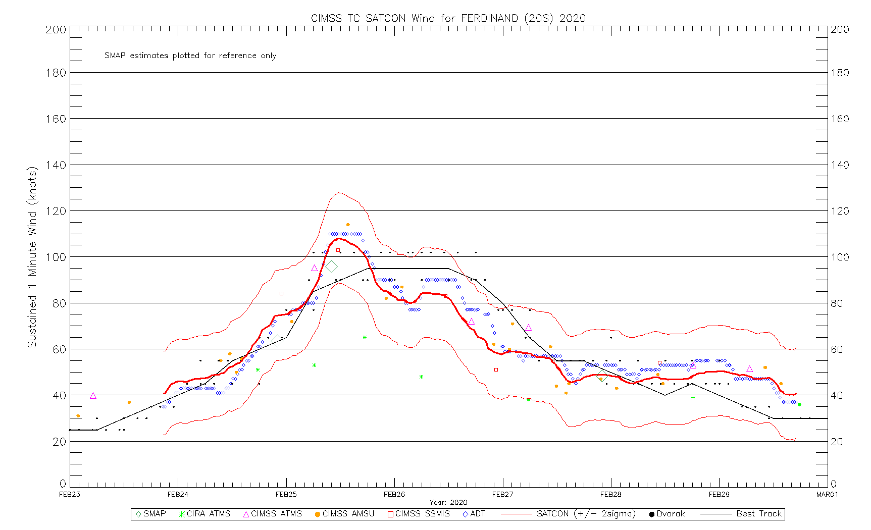
Looks like it might’ve hit 100-110 kt earlier this morning, but now the eye has completely collapsed, probably from a combination of shear and dry air intrusion.
0 likes
Irene '11 Sandy '12 Hermine '16 5/15/2018 Derecho Fay '20 Isaias '20 Elsa '21 Henri '21 Ida '21
I am only a meteorology enthusiast who knows a decent amount about tropical cyclones. Look to the professional mets, the NHC, or your local weather office for the best information.
I am only a meteorology enthusiast who knows a decent amount about tropical cyclones. Look to the professional mets, the NHC, or your local weather office for the best information.
Re: SIO: FERDINAND - Severe Tropical Cyclone
Upgraded to 95 kt 12 hours after peak intensity while being ripped apart by shear. Typical JTWC.
0 likes
Irene '11 Sandy '12 Hermine '16 5/15/2018 Derecho Fay '20 Isaias '20 Elsa '21 Henri '21 Ida '21
I am only a meteorology enthusiast who knows a decent amount about tropical cyclones. Look to the professional mets, the NHC, or your local weather office for the best information.
I am only a meteorology enthusiast who knows a decent amount about tropical cyclones. Look to the professional mets, the NHC, or your local weather office for the best information.
-
wxman57
- Moderator-Pro Met
- Posts: 23175
- Age: 68
- Joined: Sat Jun 21, 2003 8:06 pm
- Location: Houston, TX (southwest)
Re: SIO: FERDINAND - Severe Tropical Cyclone
aspen wrote:Upgraded to 95 kt 12 hours after peak intensity while being ripped apart by shear. Typical JTWC.
BoM was forecasting it to intensify today. Nope...
0 likes
-
1900hurricane

- Category 5
- Posts: 6063
- Age: 34
- Joined: Fri Feb 06, 2015 12:04 pm
- Location: Houston, TX
- Contact:
Re: SIO: FERDINAND - Severe Tropical Cyclone
Earlier SMAP supported about 100 kt. That's similar to some other microwave estimates around that time.

SH, 20, 202002251017, 30, SMAP, IR, , 1580S, 11650E, , 1, 89, 1, , , , 34, NEQ, 54, 42, 30, 48, , , , , 1, 0, , S, NASA, RSS, , , , , , , , , , , , , , , , , , , , , , , , , , , , 1, max. wind is 10 minute sustained
SH, 20, 202002251017, 30, SMAP, IR, , 1580S, 11650E, , 1, 89, 1, , , , 50, NEQ, 34, 26, 14, 30, , , , , 1, 0, , S, NASA, RSS, , , , , , , , , , , , , , , , , , , , , , , , , , , , 1, max. wind is 10 minute sustained
SH, 20, 202002251017, 30, SMAP, IR, , 1580S, 11650E, , 1, 89, 1, , , , 64, NEQ, 32, 15, 1, 1, , , , , 1, 0, , S, NASA, RSS, , , , , , , , , , , , , , , , , , , , , , , , , , , , 1, max. wind is 10 minute sustained
0 likes
Contract Meteorologist. TAMU & MSST. Fiercely authentic, one of a kind. We are all given free will, so choose a life meant to be lived. We are the Masters of our own Stories.
Opinions expressed are mine alone.
Follow me on Twitter at @1900hurricane : Read blogs at https://1900hurricane.wordpress.com/
Opinions expressed are mine alone.
Follow me on Twitter at @1900hurricane : Read blogs at https://1900hurricane.wordpress.com/
Re: SIO: FERDINAND - Severe Tropical Cyclone
I highly doubt Ferdinand has been 95 kt for the last 12 hours.
0 likes
Irene '11 Sandy '12 Hermine '16 5/15/2018 Derecho Fay '20 Isaias '20 Elsa '21 Henri '21 Ida '21
I am only a meteorology enthusiast who knows a decent amount about tropical cyclones. Look to the professional mets, the NHC, or your local weather office for the best information.
I am only a meteorology enthusiast who knows a decent amount about tropical cyclones. Look to the professional mets, the NHC, or your local weather office for the best information.
Who is online
Users browsing this forum: No registered users and 49 guests