2020 Indicators: SST's / SAL / MSLP / Steering / Shear / Instability / Sat Images

This is the general tropical discussion area. Anyone can take their shot at predicting a storms path.

Moderator: S2k Moderators

Forum rules

The posts in this forum are NOT official forecasts and should not be used as such. They are just the opinion of the poster and may or may not be backed by sound meteorological data. They are NOT endorsed by any professional institution or STORM2K. For official information, please refer to products from the National Hurricane Center and National Weather Service.

Help Support Storm2K
Message
Author
User avatar
cycloneye
Admin
Admin
Posts: 145303
Age: 68
Joined: Thu Oct 10, 2002 10:54 am
Location: San Juan, Puerto Rico

Re: 2020 Indicators: SST's / SAL / MSLP / Steering / Shear / Instability / Sat Images

#41 Postby cycloneye » Tue Feb 25, 2020 9:31 am

wxman57 wrote:Oceanic heat content (OHC) is the highest in years (since at least 2017) in the central to western Caribbean for Feb. 23rd. Positive NAO, should it continue, would mean a stronger Bermuda high. More low-level shear in the deep tropics east of the Caribbean. Much more stable than normal there now. Less subtropical development. The Caribbean may come alive this year, increasing the risk of Gulf hurricanes.


Maybe like 2007?

Image
2 likes   
Visit the Caribbean-Central America Weather Thread where you can find at first post web cams,radars
and observations from Caribbean basin members Click Here

User avatar
CyclonicFury
Category 5
Category 5
Posts: 2025
Age: 26
Joined: Sun Jul 02, 2017 12:32 pm
Location: NC
Contact:

Re: 2020 Indicators: SST's / SAL / MSLP / Steering / Shear / Instability / Sat Images

#42 Postby CyclonicFury » Tue Feb 25, 2020 10:14 am

stormlover2013 wrote:It’s a statement I made last year and I was right

Anyone can claim El Niño won't be present during ASO and will be correct about 75% of the time because there is only about a 25% climatological chance El Niño will be present during ASO. That being said, it's way too early to make absolutes, especially since we still are on the winter side of the SPB.
1 likes   
NCSU B.S. in Meteorology Class of 2021. Tropical weather blogger at http://www.cyclonicfury.com. My forecasts and thoughts are NOT official, for official forecasts please consult the National Hurricane Center.

User avatar
wxman57
Moderator-Pro Met
Moderator-Pro Met
Posts: 22978
Age: 67
Joined: Sat Jun 21, 2003 8:06 pm
Location: Houston, TX (southwest)

Re: 2020 Indicators: SST's / SAL / MSLP / Steering / Shear / Instability / Sat Images

#43 Postby wxman57 » Tue Feb 25, 2020 3:13 pm

cycloneye wrote:
wxman57 wrote:Oceanic heat content (OHC) is the highest in years (since at least 2017) in the central to western Caribbean for Feb. 23rd. Positive NAO, should it continue, would mean a stronger Bermuda high. More low-level shear in the deep tropics east of the Caribbean. Much more stable than normal there now. Less subtropical development. The Caribbean may come alive this year, increasing the risk of Gulf hurricanes.


Maybe like 2007?

https://i.imgur.com/1rxQXPA.png


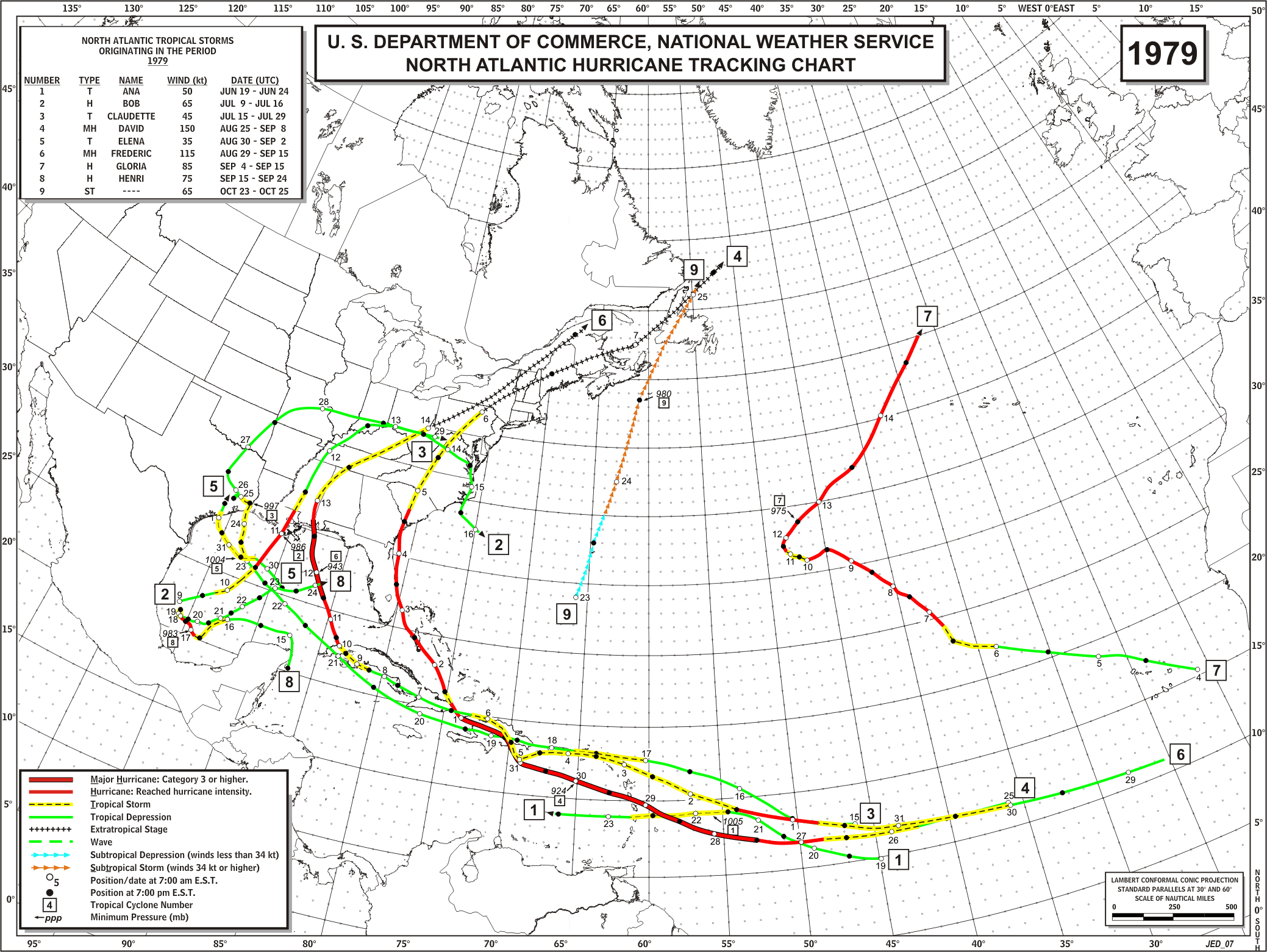
I was thinking something more like 1979 but with the Caribbean tracks a bit more to the south and farther west along the Gulf coast, plus above-normal numbers:

Image
7 likes   

User avatar
drezee
S2K Supporter
S2K Supporter
Posts: 3664
Joined: Mon Jun 09, 2003 12:49 pm
Location: FL

Re: 2020 Indicators: SST's / SAL / MSLP / Steering / Shear / Instability / Sat Images

#44 Postby drezee » Wed Feb 26, 2020 7:29 am

1979 is nonstarter...Frederick and David would be a $100 Billion dollar year again
0 likes   

Shell Mound
Category 5
Category 5
Posts: 2434
Age: 32
Joined: Thu Sep 07, 2017 3:39 pm
Location: St. Petersburg, FL → Scandinavia

Re: 2020 Indicators: SST's / SAL / MSLP / Steering / Shear / Instability / Sat Images

#45 Postby Shell Mound » Wed Feb 26, 2020 8:19 am

wxman57 wrote:
cycloneye wrote:
wxman57 wrote:Oceanic heat content (OHC) is the highest in years (since at least 2017) in the central to western Caribbean for Feb. 23rd. Positive NAO, should it continue, would mean a stronger Bermuda high. More low-level shear in the deep tropics east of the Caribbean. Much more stable than normal there now. Less subtropical development. The Caribbean may come alive this year, increasing the risk of Gulf hurricanes.


Maybe like 2007?

https://i.imgur.com/1rxQXPA.png


I was thinking something more like 1979 but with the Caribbean tracks a bit more to the south and farther west along the Gulf coast, plus above-normal numbers:

https://www.aoml.noaa.gov/hrd/hurdat/track_maps/1979_base.gif

So maybe something more akin to 1938:

Image
Source
0 likes   
CVW / MiamiensisWx / Shell Mound
The posts in this forum are NOT official forecasts and should not be used as such. They are just the opinion of the poster and may or may not be backed by sound meteorological data. They are NOT endorsed by any professional institution or STORM2K. For official information, please refer to products from the NHC and NWS.

User avatar
wxman57
Moderator-Pro Met
Moderator-Pro Met
Posts: 22978
Age: 67
Joined: Sat Jun 21, 2003 8:06 pm
Location: Houston, TX (southwest)

Re: 2020 Indicators: SST's / SAL / MSLP / Steering / Shear / Instability / Sat Images

#46 Postby wxman57 » Wed Feb 26, 2020 10:47 am

Shell Mound wrote:
wxman57 wrote:
cycloneye wrote:
Maybe like 2007?

https://i.imgur.com/1rxQXPA.png


I was thinking something more like 1979 but with the Caribbean tracks a bit more to the south and farther west along the Gulf coast, plus above-normal numbers:

https://www.aoml.noaa.gov/hrd/hurdat/track_maps/1979_base.gif

So maybe something more akin to 1938:

https://upload.wikimedia.org/wikipedia/commons/thumb/e/e0/1938_Atlantic_hurricane_season_summary_map.png/600px-1938_Atlantic_hurricane_season_summary_map.png
Source


Perhaps as far as the Caribbean & Gulf tracks, but without the great 1938 New England Hurricane.
1 likes   

TheStormExpert

Re: 2020 Indicators: SST's / SAL / MSLP / Steering / Shear / Instability / Sat Images

#47 Postby TheStormExpert » Wed Feb 26, 2020 4:12 pm

By the way things are being said on here it sounds like it MIGHT be a west Atlantic based season with more land threats than last season, 2005 even comes to mind in a sense as it was quite west Atlantic based.

Of course it is only just late February and a totally different scenario may pop up once we hit May or June once we’re past the Spring Barrier.

Maybe just maybe the -NAO will finally show up when you least expect it and the majority of storms will recurve. :lol:
1 likes   

User avatar
NotSparta
Professional-Met
Professional-Met
Posts: 1668
Age: 23
Joined: Fri Aug 18, 2017 8:24 am
Location: Naples, FL
Contact:

Re: 2020 Indicators: SST's / SAL / MSLP / Steering / Shear / Instability / Sat Images

#48 Postby NotSparta » Wed Feb 26, 2020 8:34 pm

So, looking at the current conditions one may want to lean bullish for this season, although it's February. That means this season will be inactive :lol:
1 likes   
This post was probably an opinion of mine, and in no way is official. Please refer to http://www.hurricanes.gov for official tropical analysis and advisories.

My website, with lots of tropical wx graphics, including satellite and recon: http://cyclonicwx.com

User avatar
gatorcane
S2K Supporter
S2K Supporter
Posts: 23691
Age: 47
Joined: Sun Mar 13, 2005 3:54 pm
Location: Boca Raton, FL

Re: 2020 Indicators: SST's / SAL / MSLP / Steering / Shear / Instability / Sat Images

#49 Postby gatorcane » Wed Feb 26, 2020 8:41 pm

TheStormExpert wrote:By the way things are being said on here it sounds like it MIGHT be a west Atlantic based season with more land threats than last season, 2005 even comes to mind in a sense as it was quite west Atlantic based.

Of course it is only just late February and a totally different scenario may pop up once we hit May or June once we’re past the Spring Barrier.

Maybe just maybe the -NAO will finally show up when you least expect it and the majority of storms will recurve. :lol:


A -NAO could allow storms in the Caribbean to recurve into the GOM or Florida.
0 likes   

TheStormExpert

Re: 2020 Indicators: SST's / SAL / MSLP / Steering / Shear / Instability / Sat Images

#50 Postby TheStormExpert » Wed Feb 26, 2020 11:09 pm

NotSparta wrote:So, looking at the current conditions one may want to lean bullish for this season, although it's February. That means this season will be inactive :lol:

It’s only late February and most of everyone I’ve seen are sounding bullish on the upcoming Atlantic Hurricane Season. That Spring Barrier will definitely shed some light on whether or not this is yet another active or an inactive season. I just have a hard time seeing a fifth season in a row of active Atlantic Hurricane Seasons, especially considering it’s been five years since the last successful El Niño episode.
1 likes   

User avatar
NotSparta
Professional-Met
Professional-Met
Posts: 1668
Age: 23
Joined: Fri Aug 18, 2017 8:24 am
Location: Naples, FL
Contact:

Re: 2020 Indicators: SST's / SAL / MSLP / Steering / Shear / Instability / Sat Images

#51 Postby NotSparta » Wed Feb 26, 2020 11:17 pm

TheStormExpert wrote:
NotSparta wrote:So, looking at the current conditions one may want to lean bullish for this season, although it's February. That means this season will be inactive :lol:

It’s only late February and most of everyone I’ve seen are sounding bullish on the upcoming Atlantic Hurricane Season. That Spring Barrier will definitely shed some light on whether or not this is yet another active or an inactive season. I just have a hard time seeing a fifth season in a row of active Atlantic Hurricane Seasons, especially considering it’s been five years since the last successful El Niño episode.


I'd consider 2018-19 to be successful El Niño, if weak. Things have been hanging above 0 since summer 2018 so I wouldn't be surprised to see ENSO shift back cooler. There is a lot between now and the hurricane season though, we shall see
0 likes   
This post was probably an opinion of mine, and in no way is official. Please refer to http://www.hurricanes.gov for official tropical analysis and advisories.

My website, with lots of tropical wx graphics, including satellite and recon: http://cyclonicwx.com

User avatar
Kingarabian
S2K Supporter
S2K Supporter
Posts: 15980
Joined: Sat Aug 08, 2009 3:06 am
Location: Honolulu, Hawaii

Re: 2020 Indicators: SST's / SAL / MSLP / Steering / Shear / Instability / Sat Images

#52 Postby Kingarabian » Thu Feb 27, 2020 5:14 am

TheStormExpert wrote:
NotSparta wrote:So, looking at the current conditions one may want to lean bullish for this season, although it's February. That means this season will be inactive :lol:

It’s only late February and most of everyone I’ve seen are sounding bullish on the upcoming Atlantic Hurricane Season. That Spring Barrier will definitely shed some light on whether or not this is yet another active or an inactive season. I just have a hard time seeing a fifth season in a row of active Atlantic Hurricane Seasons, especially considering it’s been five years since the last successful El Niño episode.


2018 was an official El Nino declared by the CPC. Also important to remember that El Nino is a spectrum and there are different varients. You could argue that since winter 2019, there has been a true Modoki El nino type present. But with the warm SSTs mainly over Nino 4 rather than Nino 3.4, it's not meeting the CPCs criteria.
6 likes   
RIP Kobe Bryant

User avatar
CyclonicFury
Category 5
Category 5
Posts: 2025
Age: 26
Joined: Sun Jul 02, 2017 12:32 pm
Location: NC
Contact:

Re: 2020 Indicators: SST's / SAL / MSLP / Steering / Shear / Instability / Sat Images

#53 Postby CyclonicFury » Tue Mar 03, 2020 3:27 pm

It's only March, but most of the climate models are showing quite the favorable setup for the 2020 Atlantic hurricane season. The CFS and CanSIPS seem to be in agreement on above-normal SSTs in the MDR with above-normal precipitation, along with below-normal shear in the MDR and Caribbean. The CFS is more bullish on a La Nina (which I'm somewhat skeptical about), but the CanSIPS has cool neutral to weak La Nina.

It's going to be interesting to see if the Atlantic pulls off a fifth above average season in a row. That has never happened before on record.
4 likes   
NCSU B.S. in Meteorology Class of 2021. Tropical weather blogger at http://www.cyclonicfury.com. My forecasts and thoughts are NOT official, for official forecasts please consult the National Hurricane Center.

User avatar
crownweather
S2K Supporter
S2K Supporter
Posts: 595
Age: 50
Joined: Sat Aug 12, 2006 9:21 am
Location: Sturbridge, Massachusetts
Contact:

Re: 2020 Indicators: SST's / SAL / MSLP / Steering / Shear / Instability / Sat Images

#54 Postby crownweather » Wed Mar 04, 2020 11:56 am

I've been back and forth in my thinking for the 2020 season.

On one hand, given the very warm SSTs, potential neutral ENSO conditions & the favorable look in the seasonal models, I'm tempting to go with a very busy season (15-20 Named Storms??).

On the other hand, as has been noted by others, a fifth consecutive active season would be unprecedented & that gives me pause. In addition, we are bumping up against the annual SPB & I'll be very interested to see what the ENSO models do by about May. With that said, ENSO models in previous years have been too warm (especially the ECMWF) with their ENSO forecasts.

I hate to go so bullish so quickly & will probably side more conservative with numbers when I post my own forecast later this month or early next month.

By the way, the analog years I've been looking at haven't been much help as they range from near average to super active. Some of the top analog years I'm looking at are 1933, 1952, 1959, 1990, 1998, 2005 & 2007.
6 likes   
Rob Lightbown
Crown Weather Services
https://crownweather.com

TheStormExpert

Re: 2020 Indicators: SST's / SAL / MSLP / Steering / Shear / Instability / Sat Images

#55 Postby TheStormExpert » Wed Mar 04, 2020 1:54 pm

crownweather wrote:I've been back and forth in my thinking for the 2020 season.

On one hand, given the very warm SSTs, potential neutral ENSO conditions & the favorable look in the seasonal models, I'm tempting to go with a very busy season (15-20 Named Storms??).

On the other hand, as has been noted by others, a fifth consecutive active season would be unprecedented & that gives me pause. In addition, we are bumping up against the annual SPB & I'll be very interested to see what the ENSO models do by about May. With that said, ENSO models in previous years have been too warm (especially the ECMWF) with their ENSO forecasts.

I hate to go so bullish so quickly & will probably side more conservative with numbers when I post my own forecast later this month or early next month.

By the way, the analog years I've been looking at haven't been much help as they range from near average to super active. Some of the top analog years I'm looking at are 1933, 1952, 1959, 1990, 1998, 2005 & 2007.

Of interest two of those years also had a Nashville tornado very similar to the one the other night, both 1933, and 1998.

I too am not sold on a fifth consecutive above average Atlantic Hurricane Season for the same exact reasons but that Nashville tornado is a little bit interesting.
1 likes   

User avatar
DestinHurricane
Category 4
Category 4
Posts: 935
Joined: Tue May 01, 2018 8:05 am
Location: New York, NY

Re: 2020 Indicators: SST's / SAL / MSLP / Steering / Shear / Instability / Sat Images

#56 Postby DestinHurricane » Wed Mar 04, 2020 2:18 pm

Maybe what we call an active season is beginning to become the new normal. Comparing a hurricane season in the 1930s to the 2010s or 2020s may not be a good comparison. Climate change is real...

Tomorrow the high is going to be 91 degrees here in Boca Raton. I have a thermometer on my boat and water in the atlantic has been about 5 degrees above average. Of course one single area can't speak for the entire basin but just giving an example.
5 likes   
Michael 2018

User avatar
ScottNAtlanta
Category 5
Category 5
Posts: 2367
Joined: Sat May 25, 2013 3:11 pm
Location: Atlanta, GA

Re: 2020 Indicators: SST's / SAL / MSLP / Steering / Shear / Instability / Sat Images

#57 Postby ScottNAtlanta » Wed Mar 04, 2020 4:00 pm

One thing that is similar to last year is the lack of arctic systems diving into the SE US and into the GOM. That along with little to no Nor'easters have left a lot of warm water just sitting there, and now that the sun angle is moving north, I don't see much in the future that will change that. I think this is going to be a busier than normal season with the more southern Caribbean tracks. Also the +NAO has been very persistent all year long. The MJO has been more in Phase 6 with bounces back to the Nul Phase, but little in the other phases. It is starting to look like it wants to move more toward phases 2 and 3. We will just have to see how that goes. I also don't see an El Nino this season either.
2 likes   
The posts in this forum are NOT official forecast and should not be used as such. They are just the opinion of the poster and may or may not be backed by sound meteorological data. They are NOT endorsed by any professional institution or storm2k.org. For official information, please refer to the NHC and NWS products.

User avatar
cycloneye
Admin
Admin
Posts: 145303
Age: 68
Joined: Thu Oct 10, 2002 10:54 am
Location: San Juan, Puerto Rico

Re: 2020 Indicators: SST's / SAL / MSLP / Steering / Shear / Instability / Sat Images

#58 Postby cycloneye » Wed Mar 04, 2020 4:18 pm

TheStormExpert wrote:
crownweather wrote:I've been back and forth in my thinking for the 2020 season.

On one hand, given the very warm SSTs, potential neutral ENSO conditions & the favorable look in the seasonal models, I'm tempting to go with a very busy season (15-20 Named Storms??).

On the other hand, as has been noted by others, a fifth consecutive active season would be unprecedented & that gives me pause. In addition, we are bumping up against the annual SPB & I'll be very interested to see what the ENSO models do by about May. With that said, ENSO models in previous years have been too warm (especially the ECMWF) with their ENSO forecasts.

I hate to go so bullish so quickly & will probably side more conservative with numbers when I post my own forecast later this month or early next month.

By the way, the analog years I've been looking at haven't been much help as they range from near average to super active. Some of the top analog years I'm looking at are 1933, 1952, 1959, 1990, 1998, 2005 & 2007.

Of interest two of those years also had a Nashville tornado very similar to the one the other night, both 1933, and 1998.

I too am not sold on a fifth consecutive above average Atlantic Hurricane Season for the same exact reasons but that Nashville tornado is a little bit interesting.


Why the Nashville tornado?
0 likes   
Visit the Caribbean-Central America Weather Thread where you can find at first post web cams,radars
and observations from Caribbean basin members Click Here

TheStormExpert

Re: 2020 Indicators: SST's / SAL / MSLP / Steering / Shear / Instability / Sat Images

#59 Postby TheStormExpert » Wed Mar 04, 2020 11:23 pm

cycloneye wrote:
TheStormExpert wrote:
crownweather wrote:I've been back and forth in my thinking for the 2020 season.

On one hand, given the very warm SSTs, potential neutral ENSO conditions & the favorable look in the seasonal models, I'm tempting to go with a very busy season (15-20 Named Storms??).

On the other hand, as has been noted by others, a fifth consecutive active season would be unprecedented & that gives me pause. In addition, we are bumping up against the annual SPB & I'll be very interested to see what the ENSO models do by about May. With that said, ENSO models in previous years have been too warm (especially the ECMWF) with their ENSO forecasts.

I hate to go so bullish so quickly & will probably side more conservative with numbers when I post my own forecast later this month or early next month.

By the way, the analog years I've been looking at haven't been much help as they range from near average to super active. Some of the top analog years I'm looking at are 1933, 1952, 1959, 1990, 1998, 2005 & 2007.

Of interest two of those years also had a Nashville tornado very similar to the one the other night, both 1933, and 1998.

I too am not sold on a fifth consecutive above average Atlantic Hurricane Season for the same exact reasons but that Nashville tornado is a little bit interesting.


Why the Nashville tornado?

Not sure how much (if any) correlation tornadoes have to a given hurricane season but I find it interesting that two of Crown Weathers analog seasons featured two other instances of a significant tornado tracking very similar to the recent EF-4 one a few days ago.
0 likes   

User avatar
crownweather
S2K Supporter
S2K Supporter
Posts: 595
Age: 50
Joined: Sat Aug 12, 2006 9:21 am
Location: Sturbridge, Massachusetts
Contact:

Re: 2020 Indicators: SST's / SAL / MSLP / Steering / Shear / Instability / Sat Images

#60 Postby crownweather » Wed Mar 04, 2020 11:38 pm

TheStormExpert wrote:
cycloneye wrote:
TheStormExpert wrote:Of interest two of those years also had a Nashville tornado very similar to the one the other night, both 1933, and 1998.

I too am not sold on a fifth consecutive above average Atlantic Hurricane Season for the same exact reasons but that Nashville tornado is a little bit interesting.


Why the Nashville tornado?

Not sure how much (if any) correlation tornadoes have to a given hurricane season but I find it interesting that two of Crown Weathers analog seasons featured two other instances of a significant tornado tracking very similar to the recent EF-4 one a few days ago.


What's even more intriguing is that I picked both 1933 & 1998 as possible analog years at least a couple of weeks ago when I was doing my research and was based on the weather pattern of the winter as well as various records that have been tied or broken.
1 likes   
Rob Lightbown
Crown Weather Services
https://crownweather.com


Return to “Talkin' Tropics”

Who is online

Users browsing this forum: Cdenton12, JtSmarts, Kennethb, southmdwatcher and 45 guests