I'm at 4.12" for March and 13.24" for 2020.
I noticed the green pollen dropping from the live oaks this weekend. Hopefully this week's storms will quickly knock that out of the trees and wash it away. I'm tired of worrying whether my runny nose is just allergies or the start of COVID.
Texas Spring 2020
Moderator: S2k Moderators
Forum rules

The posts in this forum are NOT official forecast and should not be used as such. They are just the opinion of the poster and may or may not be backed by sound meteorological data. They are NOT endorsed by any professional institution or STORM2K.
-
BrokenGlassRepublicn
- Category 1

- Posts: 483
- Joined: Sun Nov 20, 2011 8:07 pm
- Location: Richardson, Texas
Re: Texas Spring 2020
2 likes
-
bubba hotep

- S2K Supporter

- Posts: 6014
- Joined: Wed Dec 28, 2016 1:00 am
- Location: Collin County Texas
Re: Texas Spring 2020
Another round of overnight rain. Should be stormy when my alarm goes off at 3:30. Always love the nighttime stormy weather.
3 likes
-
Brent
- S2K Supporter
- Posts: 38737
- Age: 37
- Joined: Sun May 16, 2004 10:30 pm
- Location: Tulsa Oklahoma
- Contact:
Re: Texas Spring 2020
Another noisy storm and lots more to come
I miss talking about the weather lol
I miss talking about the weather lol
3 likes
#neversummer
Re: Texas Spring 2020
gpsnowman wrote:Another round of overnight rain. Should be stormy when my alarm goes off at 3:30. Always love the nighttime stormy weather.
Extremely heavy rain driving to work. Couldn't see well the entire way. Some good totals should come out of this round.
1 likes
Re: Texas Spring 2020
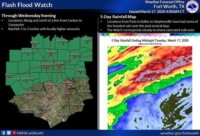
Pretty crazy morning up here! Almost 3 inches of rain and 9 inches for the month. Creeks are about to break out of their banks.
2 likes

Re: Texas Spring 2020
DonWrk wrote:Pretty crazy morning up here! Almost 3 inches of rain and 9 inches for the month. Creeks are about to break out of their banks.
Crickets down here in southeast Texas.
1 likes
-
bubba hotep
- S2K Supporter
- Posts: 6014
- Joined: Wed Dec 28, 2016 1:00 am
- Location: Collin County Texas
Re: Texas Spring 2020
Enhanced has expanded into portions of DFW

0 likes
Winter time post are almost exclusively focused on the DFW area.
-
bubba hotep
- S2K Supporter
- Posts: 6014
- Joined: Wed Dec 28, 2016 1:00 am
- Location: Collin County Texas
Re: Texas Spring 2020
Might knock off work early and drive out to see what happens.
0 likes
Winter time post are almost exclusively focused on the DFW area.
-
rwfromkansas
- Category 5

- Posts: 3032
- Joined: Sat Aug 27, 2005 12:47 am
- Location: North Fort Worth
Re: Texas Spring 2020
I didn't get much rain overnight actually. But, I had a lot this month so far. Bring on some severe weather.
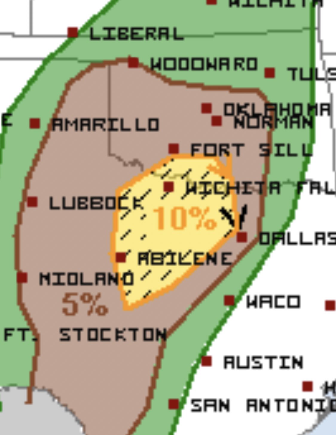
It's been odd how the dryline has been so far west this year.
On a personal note, stay safe everybody. Getting scary out there.
It's been odd how the dryline has been so far west this year.
On a personal note, stay safe everybody. Getting scary out there.
1 likes
-
Brent
- S2K Supporter
- Posts: 38737
- Age: 37
- Joined: Sun May 16, 2004 10:30 pm
- Location: Tulsa Oklahoma
- Contact:
Re: Texas Spring 2020
I'm like not paying attention to the severe threat but the sun is out and its warm out 
0 likes
#neversummer
-
bubba hotep
- S2K Supporter
- Posts: 6014
- Joined: Wed Dec 28, 2016 1:00 am
- Location: Collin County Texas
Re: Texas Spring 2020
GFS shifts the fire hose south over the next couple of weeks.

1 likes
Winter time post are almost exclusively focused on the DFW area.
-
bubba hotep
- S2K Supporter
- Posts: 6014
- Joined: Wed Dec 28, 2016 1:00 am
- Location: Collin County Texas


-
bubba hotep
- S2K Supporter
- Posts: 6014
- Joined: Wed Dec 28, 2016 1:00 am
- Location: Collin County Texas
-
Texas Snowman

- Storm2k Moderator

- Posts: 6197
- Joined: Fri Jan 25, 2008 11:29 am
- Location: Denison, Texas
Re: Texas Spring 2020
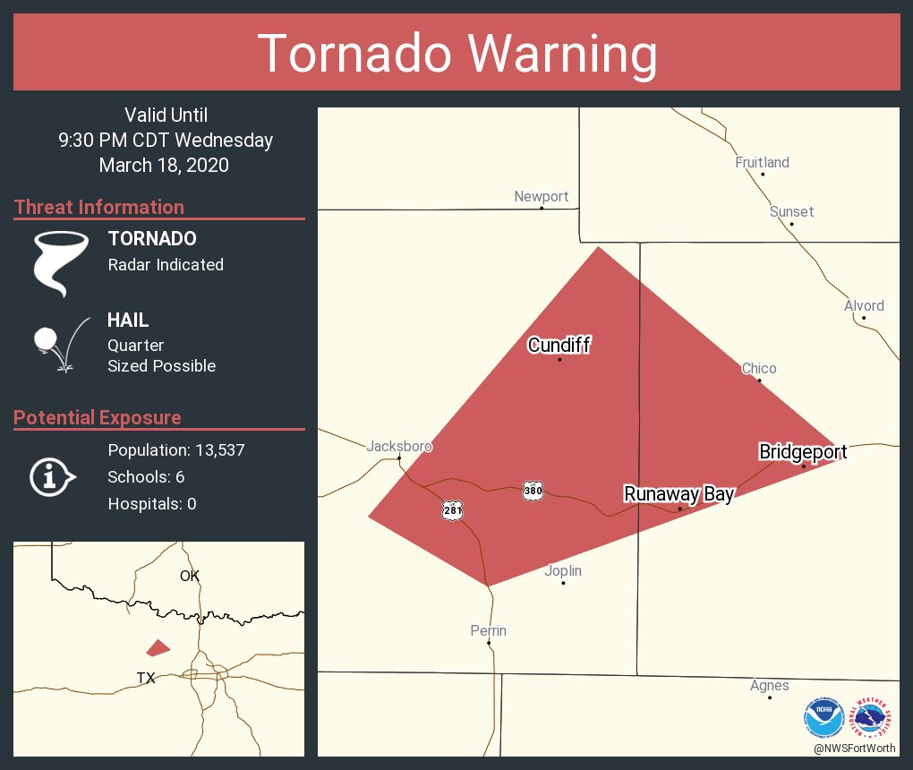
406
WFUS54 KFWD 190225
TORFWD
TXC497-190315-
/O.NEW.KFWD.TO.W.0013.200319T0225Z-200319T0315Z/
BULLETIN - EAS ACTIVATION REQUESTED
Tornado Warning
National Weather Service Fort Worth TX
925 PM CDT Wed Mar 18 2020
The National Weather Service in Fort Worth has issued a
* Tornado Warning for...
Northern Wise County in north central Texas...
* Until 1015 PM CDT.
* At 925 PM CDT, a confirmed tornado was located near Chico, or 7
miles northwest of Bridgeport, moving east at 30 mph.
HAZARD...Damaging tornado and golf ball size hail.
SOURCE...Emergency Management confirmed tornado.
IMPACT...Flying debris will be dangerous to those caught without
shelter. Mobile homes will be damaged or destroyed.
Damage to roofs, windows, and vehicles will occur. Tree
damage is likely.
* Locations impacted include...
Decatur, Bridgeport, Alvord, Chico, Runaway Bay and Lake
Bridgeport.
PRECAUTIONARY/PREPAREDNESS ACTIONS...
To repeat, a tornado is on the ground. TAKE COVER NOW! Move to an
interior room on the lowest floor of a sturdy building. Avoid
windows. If you are outdoors, in a mobile home, or in a vehicle, move
to the closest substantial shelter and protect yourself from flying
debris.
Tornadoes are extremely difficult to see and confirm at night. Do not
wait to see or hear the tornado. TAKE COVER NOW!
&&
LAT...LON 3343 9738 3322 9739 3315 9792 3337 9792
3344 9762
TIME...MOT...LOC 0225Z 257DEG 25KT 3326 9788
TORNADO...OBSERVED
HAIL...1.75IN
$$
1 likes
The above post and any post by Texas Snowman is NOT an official forecast and should not be used as such. It is just the opinion of the poster and may or may not be backed by sound meteorological data. It is NOT endorsed by any professional institution including storm2k.org. For official information, please refer to NWS products.
-
Texas Snowman
- Storm2k Moderator
- Posts: 6197
- Joined: Fri Jan 25, 2008 11:29 am
- Location: Denison, Texas
Re: Texas Spring 2020
628
WFUS54 KFWD 190231
TORFWD
TXC503-190300-
/O.NEW.KFWD.TO.W.0014.200319T0231Z-200319T0300Z/
BULLETIN - EAS ACTIVATION REQUESTED
Tornado Warning
National Weather Service Fort Worth TX
931 PM CDT Wed Mar 18 2020
The National Weather Service in Fort Worth has issued a
* Tornado Warning for...
Southeastern Young County in north central Texas...
* Until 1000 PM CDT.
* At 931 PM CDT, a severe thunderstorm capable of producing a tornado
was located 8 miles southwest of Graham, moving northeast at 30
mph.
HAZARD...Tornado and half dollar size hail.
SOURCE...Radar indicated rotation.
IMPACT...Flying debris will be dangerous to those caught without
shelter. Mobile homes will be damaged or destroyed.
Damage to roofs, windows, and vehicles will occur. Tree
damage is likely.
* Locations impacted include...
Graham.
PRECAUTIONARY/PREPAREDNESS ACTIONS...
TAKE COVER NOW! Move to an interior room on the lowest floor of a
sturdy building. Avoid windows. If you are outdoors, in a mobile
home, or in a vehicle, move to the closest substantial shelter and
protect yourself from flying debris.
Tornadoes are extremely difficult to see and confirm at night. Do not
wait to see or hear the tornado. TAKE COVER NOW!
&&
LAT...LON 3327 9866 3324 9842 3311 9843 3295 9857
3296 9874 3297 9877
TIME...MOT...LOC 0231Z 209DEG 28KT 3300 9867
TORNADO...RADAR INDICATED
HAIL...1.25IN
$$
--
1 likes
The above post and any post by Texas Snowman is NOT an official forecast and should not be used as such. It is just the opinion of the poster and may or may not be backed by sound meteorological data. It is NOT endorsed by any professional institution including storm2k.org. For official information, please refer to NWS products.
-
Texas Snowman
- Storm2k Moderator
- Posts: 6197
- Joined: Fri Jan 25, 2008 11:29 am
- Location: Denison, Texas
Re: Texas Spring 2020
@NWSFortWorth — At 0934 PM CDT. A tornado was reported just west of Chico , moving northeast. Residents of Chico should seek shelter immediately.
1 likes
The above post and any post by Texas Snowman is NOT an official forecast and should not be used as such. It is just the opinion of the poster and may or may not be backed by sound meteorological data. It is NOT endorsed by any professional institution including storm2k.org. For official information, please refer to NWS products.
-
Texas Snowman
- Storm2k Moderator
- Posts: 6197
- Joined: Fri Jan 25, 2008 11:29 am
- Location: Denison, Texas
Re: Texas Spring 2020
@TxStormChasers — 9:37PM - A large and damaging tornado has been confirmed near the Chico area in Wise County. Everyone in the Chico area should already be in shelter. If not, get there now. This is a life-threatening situation. #txwx #ntxwx
1 likes
The above post and any post by Texas Snowman is NOT an official forecast and should not be used as such. It is just the opinion of the poster and may or may not be backed by sound meteorological data. It is NOT endorsed by any professional institution including storm2k.org. For official information, please refer to NWS products.

-
Texas Snowman
- Storm2k Moderator
- Posts: 6197
- Joined: Fri Jan 25, 2008 11:29 am
- Location: Denison, Texas
Re: Texas Spring 2020
@Jeff_Piotrowski — Debris in the air power flash in the city of Chico TX.#txwx @NWSFortWorth
1 likes
The above post and any post by Texas Snowman is NOT an official forecast and should not be used as such. It is just the opinion of the poster and may or may not be backed by sound meteorological data. It is NOT endorsed by any professional institution including storm2k.org. For official information, please refer to NWS products.
Return to “USA & Caribbean Weather”
Who is online
Users browsing this forum: Yukon Cornelius and 52 guests