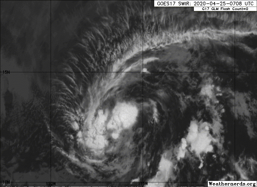
Convection has balled up nicely now and the circulation appears a bit tighter. It's not perfect, but if this was a recon storm I'm betting they would find a tropical storm with 40-45kt winds.
What model showed this, or at least something like it, first? I'd say it was a win for that model.
EPAC: ONE-E - Remnants
Moderator: S2k Moderators
-
cycloneye

- Admin

- Posts: 149275
- Age: 69
- Joined: Thu Oct 10, 2002 10:54 am
- Location: San Juan, Puerto Rico
Re: EPAC: INVEST 90E
0 likes
Visit the Caribbean-Central America Weather Thread where you can find at first post web cams,radars
and observations from Caribbean basin members Click Here
and observations from Caribbean basin members Click Here
-
cycloneye
- Admin
- Posts: 149275
- Age: 69
- Joined: Thu Oct 10, 2002 10:54 am
- Location: San Juan, Puerto Rico
Re: EPAC: INVEST 90E
TD?
90E INVEST 200425 1200 13.9N 115.8W EPAC 30 1006
90E INVEST 200425 1200 13.9N 115.8W EPAC 30 1006
0 likes
Visit the Caribbean-Central America Weather Thread where you can find at first post web cams,radars
and observations from Caribbean basin members Click Here
and observations from Caribbean basin members Click Here
-
Sciencerocks
- Category 5

- Posts: 10181
- Age: 40
- Joined: Thu Jul 06, 2017 1:51 am
-
Nancy Smar

- Category 5
- Posts: 1081
- Age: 25
- Joined: Wed Aug 16, 2017 10:03 pm
Re: EPAC: INVEST 90E
EP, 01, 2020042512, 03, OFCL, 0, 139N, 1158W, 30, 0, TD, 34, NEQ, 0, 0, 0, 0, 0, 0, 0, 40, 0, , 0, DAZ, 315, 6,
EP, 01, 2020042512, 03, OFCL, 3, 142N, 1160W, 30, 1006, TD, 34, NEQ, 0, 0, 0, 0, 0, 0, 0, 40, 0, , 0, DAZ, 325, 7,
EP, 01, 2020042512, 03, OFCL, 12, 149N, 1168W, 30, 0, DB, 34, NEQ, 0, 0, 0, 0, 0, 0, 0, 40, 0, , 0, DAZ, 310, 7,
EP, 01, 2020042512, 03, OFCL, 24, 159N, 1181W, 30, 0, DB, 34, NEQ, 0, 0, 0, 0, 0, 0, 0, 40, 0, , 0, DAZ, 310, 8,
EP, 01, 2020042512, 03, OFCL, 36, 167N, 1198W, 25, 0, DB, 34, NEQ, 0, 0, 0, 0, 0, 0, 0, 35, 0, , 0, DAZ, 295, 9,
EP, 01, 2020042512, 03, OFCL, 48, 171N, 1217W, 25, 0, DB, 34, NEQ, 0, 0, 0, 0, 0, 0, 0, 35, 0, , 0, DAZ, 285, 9,
EP, 01, 2020042512, 03, OFCL, 60, 172N, 1240W, 20, 0, DB, 34, NEQ, 0, 0, 0, 0, 0, 0, 0, 30, 0, , 0, DAZ, 275, 11,
1 likes

Re: EPAC: INVEST 90E
Looking good, almost seems like it has a closed circulation now.
0 likes
Irene '11 Sandy '12 Hermine '16 5/15/2018 Derecho Fay '20 Isaias '20 Elsa '21 Henri '21 Ida '21
I am only a meteorology enthusiast who knows a decent amount about tropical cyclones. Look to the professional mets, the NHC, or your local weather office for the best information.
I am only a meteorology enthusiast who knows a decent amount about tropical cyclones. Look to the professional mets, the NHC, or your local weather office for the best information.
-
Yellow Evan

- Professional-Met

- Posts: 16231
- Age: 27
- Joined: Fri Jul 15, 2011 12:48 pm
- Location: Henderson, Nevada/Honolulu, HI
- Contact:
Re: EPAC: ONE - Tropical Depression
000
ABPZ20 KNHC 250138
TWOEP
Special Tropical Weather Outlook
NWS National Hurricane Center Miami FL
640 PM PDT Fri Apr 24 2020
For the eastern North Pacific...east of 140 degrees west longitude:
Special Outlook issued to update discussion on the low pressure area
located well south-southwest of Baja California Sur.
Showers and thunderstorms associated with a broad area of low
pressure located about 800 miles south-southwest of the southern
tip of Baja California Sur have changed little in organization
today. Environmental conditions are forecast to be conducive for
further development, and a tropical depression is likely to form
during the next day or so while the system moves northwestward at
around 10 mph. By Sunday, upper-level winds should become
unfavorable for development. The next Special Tropical Weather
Outlook on this system will be issued by 8 AM PDT Saturday, or
earlier, if necessary.
* Formation chance through 48 hours...high...80 percent.
* Formation chance through 5 days...high...80 percent.
$$
Forecaster Blake
0 likes
-
Dylan

- Professional-Met
- Posts: 338
- Age: 31
- Joined: Mon May 31, 2010 9:50 am
- Location: New Orleans, LA
Re: EPAC: ONE - Tropical Depression
4 likes
Georges('98), Allison('01), Isidore('02), Lili('02), Frances('04) Ivan('04), Cindy('05), Katrina('05), Rita('05), Gustav('08), Isaac('12), Matthew('16), Harvey('17), Irma('17), Nate ('17), Ida ('21).
-
Kingarabian

- S2K Supporter

- Posts: 16348
- Joined: Sat Aug 08, 2009 3:06 am
- Location: Honolulu, Hawaii
-
Sciencerocks
- Category 5
- Posts: 10181
- Age: 40
- Joined: Thu Jul 06, 2017 1:51 am
Re: EPAC: ONE-E - Tropical Depression
Tropical Depression One-E Discussion Number 1
NWS National Hurricane Center Miami FL EP012020
800 AM PDT Sat Apr 25 2020
Overnight ASCAT data showed the disturbance over the central eastern
Pacific basin has developed a well-defined center. Furthermore,
convection associated with the low has increased in organization
since yesterday. Advisories have therefore been initiated on
Tropical Depression One-E. The initial intensity is set at 30 kt
based primarily on the aforementioned ASCAT data. This marks
the earliest formation of a tropical cyclone in the eastern North
Pacific basin since the satellite era began in 1966.
The depression is not expected to stick around for long. Dry air in
the surrounding environment appears to have already wrapped around
much of the cyclone's circulation, and this is likely limiting its
associated convection. This should also prevent the depression from
strengthening much during the next 24 h, but it can not be ruled out
that the system could briefly become a tropical storm later today.
On Sunday, an increase in vertical wind shear and lower SSTs along
the forecast track will contribute to the depression's demise, and
it is expected to become a remnant low within about 36 h, if not
sooner.
The initial motion estimate is northwest at 6 kt. The depression
should continue on a general northwestward heading for another day
or so until it becomes a remnant low. The remnants should then turn
westward with the low-level trade wind flow until it dissipates
entirely in a couple of days.
FORECAST POSITIONS AND MAX WINDS
INIT 25/1500Z 14.1N 116.1W 30 KT 35 MPH
12H 26/0000Z 14.9N 116.8W 30 KT 35 MPH
24H 26/1200Z 15.9N 118.1W 30 KT 35 MPH
36H 27/0000Z 16.7N 119.8W 25 KT 30 MPH...POST-TROP/REMNT LOW
48H 27/1200Z 17.1N 121.7W 25 KT 30 MPH...POST-TROP/REMNT LOW
72H 28/1200Z...DISSIPATED
$$
Forecaster Zelinsky
0 likes
Re: EPAC: ONE-E - Tropical Depression
She did it. The mad lad actually did it. We have an EPac cyclone in April, 20 days before the season starts.
Eat your heart out, Adrian ‘17.
Eat your heart out, Adrian ‘17.
4 likes
Irene '11 Sandy '12 Hermine '16 5/15/2018 Derecho Fay '20 Isaias '20 Elsa '21 Henri '21 Ida '21
I am only a meteorology enthusiast who knows a decent amount about tropical cyclones. Look to the professional mets, the NHC, or your local weather office for the best information.
I am only a meteorology enthusiast who knows a decent amount about tropical cyclones. Look to the professional mets, the NHC, or your local weather office for the best information.
-
TheStormExpert
Re: EPAC: ONE-E - Tropical Depression
aspen wrote:She did it. The mad lad actually did it. We have an EPac cyclone in April, 20 days before the season starts.
Eat your heart out, Adrian ‘17.
Though it looks at the moment it will likely remain a Tropical Depression.
1 likes
-
Astromanía
- Category 2

- Posts: 793
- Age: 27
- Joined: Sat Aug 25, 2018 10:34 pm
- Location: Monterrey, N.L, México
Re: EPAC: ONE-E - Tropical Depression
YESSSS! Congratulations EPAC! Beautiful system for the time!
2 likes
Re: EPAC: ONE-E - Tropical Depression
TheStormExpert wrote:aspen wrote:She did it. The mad lad actually did it. We have an EPac cyclone in April, 20 days before the season starts.
Eat your heart out, Adrian ‘17.
Though it looks at the moment it will likely remain a Tropical Depression.
True, but impressive nonetheless. Last year, the first system didn’t form until the very end of June.
1 likes
Irene '11 Sandy '12 Hermine '16 5/15/2018 Derecho Fay '20 Isaias '20 Elsa '21 Henri '21 Ida '21
I am only a meteorology enthusiast who knows a decent amount about tropical cyclones. Look to the professional mets, the NHC, or your local weather office for the best information.
I am only a meteorology enthusiast who knows a decent amount about tropical cyclones. Look to the professional mets, the NHC, or your local weather office for the best information.
-
hurricanes1234
- Category 5
- Posts: 2908
- Joined: Sat Jul 28, 2012 6:19 pm
- Location: Trinidad and Tobago
Re: EPAC: ONE-E - Tropical Depression
Woohoo he did it!!! 
1 likes
PLEASE NOTE: With the exception of information from weather agencies that I may copy and paste here, my posts will NEVER be official, since I am NOT a meteorologist. They are solely my amateur opinion, and may or may not be accurate. Therefore, please DO NOT use them as official details, particularly when making important decisions. Thank you.


Re: EPAC: ONE-E - Tropical Depression
OOF. This thing got the TD designation.
Let's see if she'll get a name? C'mon Mandy.
Let's see if she'll get a name? C'mon Mandy.
2 likes
blonde stacey (xe/xem/xir)
-
1900hurricane

- Category 5
- Posts: 6063
- Age: 34
- Joined: Fri Feb 06, 2015 12:04 pm
- Location: Houston, TX
- Contact:
Re: EPAC: ONE-E - Tropical Depression
Woo, got it in best track now!
EP, 01, 2020042212, , BEST, 0, 98N, 1082W, 20, 1009, DB, 0, , 0, 0, 0, 0, 1010, 300, 60, 0, 0, , 0, , 0, 0, GENESIS001, , 0, , 0, 0, 0, 0, genesis-num, 001,
EP, 01, 2020042218, , BEST, 0, 98N, 1092W, 20, 1009, DB, 0, , 0, 0, 0, 0, 1010, 300, 60, 0, 0, , 0, , 0, 0, GENESIS001, , 0, , 0, 0, 0, 0, genesis-num, 001,
EP, 01, 2020042300, , BEST, 0, 99N, 1101W, 20, 1009, DB, 0, , 0, 0, 0, 0, 1010, 300, 60, 0, 0, , 0, , 0, 0, GENESIS001, , 0, , 0, 0, 0, 0, genesis-num, 001,
EP, 01, 2020042306, , BEST, 0, 100N, 1111W, 20, 1009, DB, 0, , 0, 0, 0, 0, 1010, 300, 60, 0, 0, , 0, , 0, 0, GENESIS001, , 0, , 0, 0, 0, 0, genesis-num, 001,
EP, 01, 2020042312, , BEST, 0, 102N, 1120W, 25, 1008, DB, 0, , 0, 0, 0, 0, 1010, 300, 60, 0, 0, E, 0, , 0, 0, INVEST, S, 0, , 0, 0, 0, 0, genesis-num, 001, SPAWNINVEST, ep712020 to ep902020,
EP, 01, 2020042318, , BEST, 0, 105N, 1130W, 25, 1008, DB, 0, , 0, 0, 0, 0, 1010, 300, 60, 0, 0, E, 0, , 0, 0, INVEST, S, 0, , 0, 0, 0, 0, genesis-num, 001,
EP, 01, 2020042400, , BEST, 0, 107N, 1133W, 25, 1008, DB, 0, , 0, 0, 0, 0, 1010, 300, 60, 0, 0, E, 0, , 0, 0, INVEST, S, 0, , 0, 0, 0, 0, genesis-num, 001,
EP, 01, 2020042406, , BEST, 0, 111N, 1137W, 30, 1008, DB, 0, , 0, 0, 0, 0, 1010, 300, 60, 0, 0, E, 0, , 0, 0, INVEST, M, 0, , 0, 0, 0, 0, genesis-num, 001,
EP, 01, 2020042412, , BEST, 0, 118N, 1143W, 30, 1007, DB, 0, , 0, 0, 0, 0, 1009, 240, 40, 0, 0, E, 0, , 0, 0, INVEST, M, 0, , 0, 0, 0, 0, genesis-num, 001,
EP, 01, 2020042418, , BEST, 0, 125N, 1148W, 25, 1007, DB, 0, , 0, 0, 0, 0, 1009, 240, 40, 40, 0, E, 0, , 0, 0, INVEST, M, 0, , 0, 0, 0, 0, genesis-num, 001,
EP, 01, 2020042500, , BEST, 0, 130N, 1151W, 25, 1007, DB, 0, , 0, 0, 0, 0, 1009, 240, 40, 0, 0, E, 0, , 0, 0, INVEST, M, 0, , 0, 0, 0, 0, genesis-num, 001,
EP, 01, 2020042506, , BEST, 0, 135N, 1154W, 30, 1007, DB, 0, , 0, 0, 0, 0, 1009, 240, 40, 0, 0, E, 0, , 0, 0, INVEST, M, 0, , 0, 0, 0, 0, genesis-num, 001,
EP, 01, 2020042512, , BEST, 0, 139N, 1158W, 30, 1006, TD, 34, NEQ, 0, 0, 0, 0, 1010, 200, 40, 40, 0, E, 0, , 0, 0, ONE, M, 0, , 0, 0, 0, 0, genesis-num, 001, TRANSITIONED, epA02020 to ep012020,
4 likes
Contract Meteorologist. TAMU & MSST. Fiercely authentic, one of a kind. We are all given free will, so choose a life meant to be lived. We are the Masters of our own Stories.
Opinions expressed are mine alone.
Follow me on Twitter at @1900hurricane : Read blogs at https://1900hurricane.wordpress.com/
Opinions expressed are mine alone.
Follow me on Twitter at @1900hurricane : Read blogs at https://1900hurricane.wordpress.com/
-
AnnularCane

- S2K Supporter
- Posts: 2957
- Joined: Thu Jun 08, 2006 9:18 am
- Location: Wytheville, VA
Re: EPAC: ONE-E - Tropical Depression
aspen wrote:She did it. The mad lad actually did it. We have an EPac cyclone in April, 20 days before the season starts.
Eat your heart out, Adrian ‘17.
Don't you mean lass?
6 likes
-
Yellow Evan
- Professional-Met
- Posts: 16231
- Age: 27
- Joined: Fri Jul 15, 2011 12:48 pm
- Location: Henderson, Nevada/Honolulu, HI
- Contact:
Re: EPAC: ONE-E - Tropical Depression
----- Current Analysis -----
Date : 25 APR 2020 Time : 182032 UTC
Lat : 14:22:37 N Lon : 116:22:12 W
CI# /Pressure/ Vmax
2.2 /1007.4mb/ 32.0kt
Final T# Adj T# Raw T#
2.2 2.4 2.4
Center Temp : +9.8C Cloud Region Temp : -9.8C
Scene Type : SHEAR (0.50^ TO DG)
Date : 25 APR 2020 Time : 182032 UTC
Lat : 14:22:37 N Lon : 116:22:12 W
CI# /Pressure/ Vmax
2.2 /1007.4mb/ 32.0kt
Final T# Adj T# Raw T#
2.2 2.4 2.4
Center Temp : +9.8C Cloud Region Temp : -9.8C
Scene Type : SHEAR (0.50^ TO DG)
0 likes
-
Yellow Evan
- Professional-Met
- Posts: 16231
- Age: 27
- Joined: Fri Jul 15, 2011 12:48 pm
- Location: Henderson, Nevada/Honolulu, HI
- Contact:
Re: EPAC: ONE-E - Tropical Depression
EP, 01, 202004251507, 30, AMSU, IP, , 1413N, 11598W, , 1, 34, 2, 1003, 2, MEAS, , , , , , , , , , , 2, , , E, CIRA, JAK, , , , , , , 1003, , NOAA15, , , , , , , , , , , , , , , , , , , 2, storm center extrapolated from t=-12 and t=0 adeck
EP, 01, 202004251750, 20, DVTO, I, , 1433N, 11633W, , 3, 31, 2, 1007, 2, DVRK, , , , , , , , , , , , , , , CIMS, AUT, I, 21, 2, 21, 3, L, 23, 8, -9, SHER, , GOES17, ,
EP, 01, 202004251800, 10, DVTS, CI, , 1420N, 11640W, , 3, 25, 2, , 2, DVRK, , , , , , , , , , , , , , E, TAFB, AL, VI, 5, 1515 /////, , , GOES17, CSC, T,
0 likes
Who is online
Users browsing this forum: No registered users and 20 guests