2020 Indicators: SST's / SAL / MSLP / Steering / Shear / Instability / Sat Images

This is the general tropical discussion area. Anyone can take their shot at predicting a storms path.

Moderator: S2k Moderators

Forum rules

The posts in this forum are NOT official forecasts and should not be used as such. They are just the opinion of the poster and may or may not be backed by sound meteorological data. They are NOT endorsed by any professional institution or STORM2K. For official information, please refer to products from the National Hurricane Center and National Weather Service.

Help Support Storm2K
Message
Author
Shell Mound
Category 5
Category 5
Posts: 2434
Age: 32
Joined: Thu Sep 07, 2017 3:39 pm
Location: St. Petersburg, FL → Scandinavia

Re: 2020 Indicators: SST's / SAL / MSLP / Steering / Shear / Instability / Sat Images

#401 Postby Shell Mound » Tue May 05, 2020 1:13 pm

NotSparta wrote:
Shell Mound wrote:Most of the cooling in SSTs over the MDR and Caribbean has occurred since 20 April, per Tropical Tidbits’ data. I used ESRL’s plotting and analysis page to compare the change in MSLP, SST, and precipitation-rate (mm/h) anomalies during the period 20 April–1 May vs. the first nineteen days of April. I examined the region between 45°S–45°N and 120°W–40°E. Based on ESRL’s output, I found no significant change in any of these variables over the MDR and Caribbean, so USTropics’ explanation as to the cooling does not seem to hold, at least based on ESRL’s data. Therefore, the significant cooling is likely related to the AMO rather than convection, stronger high pressure, or other factors.


That's not how it works, the AMO can't just magically cool down the MDR. It needs help from other sources like trade wind variability or insolation fluxes. Problem is, the data isn't perfect. The SST data will have problems, missing areas and biases. In addition, the ESRL data isn't perfect as well, so it could be missing some things too. More likely there was a trade wind outbreak or a fall in insolation (SAL would do it and also make SST datasets overdo the fall). AMO variations are much more gradual than this, there have been tons of short term crashes like this even in the peak of the +AMO period.

Based on satellite data, the recent cooling does appear to be largely related to a recent, significant SAL outbreak—well within seasonal norms. If anything, the SST signature over the subtropical and even part of the far North Atlantic has become significantly more favourable over the past several weeks, with the overall look being much closer to a budding +AMO than it was a few months ago. Also, one can note a long-term southward shift in the warm tongue north of the MDR. So if one discards the recent SAL-related cooling over the MDR and Caribbean, the actual evolution over the past several weeks, coupled with the slow but steady +SOI trend and the persistent +IOD (hence enhanced rainfall over the equatorial Sahel due to a strong African monsoon), does not augur well for those hoping for an average or slightly-above-average Atlantic season. Indications are that we may well end up with La Niña conditions and a corresponding -PDO by the peak of the Atlantic season. So the risk of a hyperactive season with steering currents favouring landfalls seems to be increasing.
3 likes   
CVW / MiamiensisWx / Shell Mound
The posts in this forum are NOT official forecasts and should not be used as such. They are just the opinion of the poster and may or may not be backed by sound meteorological data. They are NOT endorsed by any professional institution or STORM2K. For official information, please refer to products from the NHC and NWS.

User avatar
toad strangler
S2K Supporter
S2K Supporter
Posts: 4543
Joined: Sun Jul 28, 2013 3:09 pm
Location: Earth
Contact:

Re: 2020 Indicators: SST's / SAL / MSLP / Steering / Shear / Instability / Sat Images

#402 Postby toad strangler » Tue May 05, 2020 1:17 pm

tolakram wrote:The hype for this season seems a little over the top. Even if it's busy, and last I checked season predictions are not all that good, we don't know how many, if any, will impact land. Hope for the best, prepare for the worst!


I don't see any hype. All I see are Indicators.
5 likes   

User avatar
cycloneye
Admin
Admin
Posts: 145303
Age: 68
Joined: Thu Oct 10, 2002 10:54 am
Location: San Juan, Puerto Rico

Re: 2020 Indicators: SST's / SAL / MSLP / Steering / Shear / Instability / Sat Images

#403 Postby cycloneye » Tue May 05, 2020 1:18 pm

Shell Mound wrote:
NotSparta wrote:
Shell Mound wrote:Most of the cooling in SSTs over the MDR and Caribbean has occurred since 20 April, per Tropical Tidbits’ data. I used ESRL’s plotting and analysis page to compare the change in MSLP, SST, and precipitation-rate (mm/h) anomalies during the period 20 April–1 May vs. the first nineteen days of April. I examined the region between 45°S–45°N and 120°W–40°E. Based on ESRL’s output, I found no significant change in any of these variables over the MDR and Caribbean, so USTropics’ explanation as to the cooling does not seem to hold, at least based on ESRL’s data. Therefore, the significant cooling is likely related to the AMO rather than convection, stronger high pressure, or other factors.


That's not how it works, the AMO can't just magically cool down the MDR. It needs help from other sources like trade wind variability or insolation fluxes. Problem is, the data isn't perfect. The SST data will have problems, missing areas and biases. In addition, the ESRL data isn't perfect as well, so it could be missing some things too. More likely there was a trade wind outbreak or a fall in insolation (SAL would do it and also make SST datasets overdo the fall). AMO variations are much more gradual than this, there have been tons of short term crashes like this even in the peak of the +AMO period.

Based on satellite data, the recent cooling does appear to be largely related to a recent, significant SAL outbreak—well within seasonal norms. If anything, the SST signature over the subtropical and even part of the far North Atlantic has become significantly more favourable over the past several weeks, with the overall look being much closer to a budding +AMO than it was a few months ago. Also, one can note a long-term southward shift in the warm tongue north of the MDR. So if one discards the recent SAL-related cooling over the MDR and Caribbean, the actual evolution over the past several weeks, coupled with the slow but steady +SOI trend and the persistent +IOD (hence enhanced rainfall over the equatorial Sahel due to a strong African monsoon), does not augur well for those hoping for an average or slightly-above-average Atlantic season. Indications are that we may well end up with La Niña conditions and a corresponding -PDO by the peak of the Atlantic season. So the risk of a hyperactive season with steering currents favouring landfalls seems to be increasing.


The evidence keeps mounting for a very active season so good that you finnally see it. The ENSO Thread says it all.
4 likes   
Visit the Caribbean-Central America Weather Thread where you can find at first post web cams,radars
and observations from Caribbean basin members Click Here

User avatar
galaxy401
Category 5
Category 5
Posts: 2419
Age: 30
Joined: Sat Aug 25, 2012 9:04 pm
Location: Casa Grande, Arizona

Re: 2020 Indicators: SST's / SAL / MSLP / Steering / Shear / Instability / Sat Images

#404 Postby galaxy401 » Tue May 05, 2020 1:33 pm

I wonder if the Gulf of Mexico will see a cooldown through the month of May. Most of the eastern half of the USA is seeing unusually cold weather right now and I wonder if that contribute to the region cooling down as well.
0 likes   
Got my eyes on moving right into Hurricane Alley: Florida.

psyclone
S2K Supporter
S2K Supporter
Posts: 4762
Joined: Wed Aug 24, 2005 9:04 pm
Location: palm harbor fl

Re: 2020 Indicators: SST's / SAL / MSLP / Steering / Shear / Instability / Sat Images

#405 Postby psyclone » Tue May 05, 2020 1:34 pm

tolakram wrote:The hype for this season seems a little over the top. Even if it's busy, and last I checked season predictions are not all that good, we don't know how many, if any, will impact land. Hope for the best, prepare for the worst!


This is a great point. Recall the hysteria the preceded the 2006 season after the nightmare that was 2005. To be fair it does look active. But sometimes the consensus is wrong
3 likes   

TheStormExpert

Re: 2020 Indicators: SST's / SAL / MSLP / Steering / Shear / Instability / Sat Images

#406 Postby TheStormExpert » Tue May 05, 2020 3:07 pm

galaxy401 wrote:I wonder if the Gulf of Mexico will see a cooldown through the month of May. Most of the eastern half of the USA is seeing unusually cold weather right now and I wonder if that contribute to the region cooling down as well.

The Gulf of Mexico is cooling as a result. Regardless it is still warm enough to support TC development, I’m sure I’m the summer months once these fronts stop coming as far south as they’re it’ll quickly rebound, so no problems there in terms of lack of service warmth.
1 likes   

User avatar
HurricaneEnzo
Category 2
Category 2
Posts: 739
Joined: Wed Mar 14, 2018 12:18 pm
Location: Newport, NC (Hurricane Alley)

Re: 2020 Indicators: SST's / SAL / MSLP / Steering / Shear / Instability / Sat Images

#407 Postby HurricaneEnzo » Tue May 05, 2020 4:22 pm

TheStormExpert wrote:
galaxy401 wrote:I wonder if the Gulf of Mexico will see a cooldown through the month of May. Most of the eastern half of the USA is seeing unusually cold weather right now and I wonder if that contribute to the region cooling down as well.

The Gulf of Mexico is cooling as a result. Regardless it is still warm enough to support TC development, I’m sure I’m the summer months once these fronts stop coming as far south as they’re it’ll quickly rebound, so no problems there in terms of lack of service warmth.


Yeah I would probably expect to see some slight cooling throughout most of May. While still out in fantasy land models are indicating once we get past this cool spell in mid-May the torch is going to return towards the end of the month. If that does happen things have plenty of time to get warmed up for peak season. This prolonged cool could help keep some of those early season junk systems at bay maybe.
1 likes   
Bertha 96' - Fran 96' - Bonnie 98' - Dennis 99' - Floyd 99' - Isabel 03' - Alex 04' - Ophelia 05' - Irene 11' - Arthur 14' - Matthew 16' - Florence 18' - Dorian 19' - Isaias 20' (countless other tropical storms and Hurricane swipes)

I am not a Professional Met just an enthusiast. Get your weather forecasts from the Pros!

User avatar
toad strangler
S2K Supporter
S2K Supporter
Posts: 4543
Joined: Sun Jul 28, 2013 3:09 pm
Location: Earth
Contact:

Re: 2020 Indicators: SST's / SAL / MSLP / Steering / Shear / Instability / Sat Images

#408 Postby toad strangler » Tue May 05, 2020 4:35 pm

psyclone wrote:
tolakram wrote:The hype for this season seems a little over the top. Even if it's busy, and last I checked season predictions are not all that good, we don't know how many, if any, will impact land. Hope for the best, prepare for the worst!


This is a great point. Recall the hysteria the preceded the 2006 season after the nightmare that was 2005. To be fair it does look active. But sometimes the consensus is wrong


Who is hyping anything? Is he talking about some of the pre season pro outlooks or the posts on this forum?
Last edited by toad strangler on Tue May 05, 2020 4:36 pm, edited 1 time in total.
0 likes   

TheStormExpert

Re: 2020 Indicators: SST's / SAL / MSLP / Steering / Shear / Instability / Sat Images

#409 Postby TheStormExpert » Tue May 05, 2020 4:35 pm

HurricaneEnzo wrote:
TheStormExpert wrote:
galaxy401 wrote:I wonder if the Gulf of Mexico will see a cooldown through the month of May. Most of the eastern half of the USA is seeing unusually cold weather right now and I wonder if that contribute to the region cooling down as well.

The Gulf of Mexico is cooling as a result. Regardless it is still warm enough to support TC development, I’m sure I’m the summer months once these fronts stop coming as far south as they’re it’ll quickly rebound, so no problems there in terms of lack of service warmth.


Yeah I would probably expect to see some slight cooling throughout most of May. While still out in fantasy land models are indicating once we get past this cool spell in mid-May the torch is going to return towards the end of the month. If that does happen things have plenty of time to get warmed up for peak season. This prolonged cool could help keep some of those early season junk systems at bay maybe.

Yeah there are indications that later this month the pattern flips to less troughiness in the Eastern U.S. and maybe more ridging which will likely cut off the fronts from passing into or even close to the Gulf of Mexico or northern Gulf Coast. Still may have to watch out for potential systems to spin up from the Central America Gyre late-May into early-June.
1 likes   

TheStormExpert

Re: 2020 Indicators: SST's / SAL / MSLP / Steering / Shear / Instability / Sat Images

#410 Postby TheStormExpert » Tue May 05, 2020 4:39 pm

toad strangler wrote:
psyclone wrote:
tolakram wrote:The hype for this season seems a little over the top. Even if it's busy, and last I checked season predictions are not all that good, we don't know how many, if any, will impact land. Hope for the best, prepare for the worst!


This is a great point. Recall the hysteria the preceded the 2006 season after the nightmare that was 2005. To be fair it does look active. But sometimes the consensus is wrong


Who is hyping anything? Is he talking about some of the pre season pro forecasts or the posts on this forum?

He’s referring to how people were over-hyping the 2006 Atlantic season in that spring thanks to the recent activity in 2004/2005 which busted big time thanks to a moderate El Niño that summer.

Obviously no one is overhyping anything this year with what’s all going on especially considering there are NO indications of an El Niño.
0 likes   

TheStormExpert

Re: 2020 Indicators: SST's / SAL / MSLP / Steering / Shear / Instability / Sat Images

#411 Postby TheStormExpert » Tue May 05, 2020 4:41 pm

Shell Mound wrote:
NotSparta wrote:
Shell Mound wrote:Most of the cooling in SSTs over the MDR and Caribbean has occurred since 20 April, per Tropical Tidbits’ data. I used ESRL’s plotting and analysis page to compare the change in MSLP, SST, and precipitation-rate (mm/h) anomalies during the period 20 April–1 May vs. the first nineteen days of April. I examined the region between 45°S–45°N and 120°W–40°E. Based on ESRL’s output, I found no significant change in any of these variables over the MDR and Caribbean, so USTropics’ explanation as to the cooling does not seem to hold, at least based on ESRL’s data. Therefore, the significant cooling is likely related to the AMO rather than convection, stronger high pressure, or other factors.


That's not how it works, the AMO can't just magically cool down the MDR. It needs help from other sources like trade wind variability or insolation fluxes. Problem is, the data isn't perfect. The SST data will have problems, missing areas and biases. In addition, the ESRL data isn't perfect as well, so it could be missing some things too. More likely there was a trade wind outbreak or a fall in insolation (SAL would do it and also make SST datasets overdo the fall). AMO variations are much more gradual than this, there have been tons of short term crashes like this even in the peak of the +AMO period.

Based on satellite data, the recent cooling does appear to be largely related to a recent, significant SAL outbreak—well within seasonal norms. If anything, the SST signature over the subtropical and even part of the far North Atlantic has become significantly more favourable over the past several weeks, with the overall look being much closer to a budding +AMO than it was a few months ago. Also, one can note a long-term southward shift in the warm tongue north of the MDR. So if one discards the recent SAL-related cooling over the MDR and Caribbean, the actual evolution over the past several weeks, coupled with the slow but steady +SOI trend and the persistent +IOD (hence enhanced rainfall over the equatorial Sahel due to a strong African monsoon), does not augur well for those hoping for an average or slightly-above-average Atlantic season. Indications are that we may well end up with La Niña conditions and a corresponding -PDO by the peak of the Atlantic season. So the risk of a hyperactive season with steering currents favouring landfalls seems to be increasing.

What happen to your optimistic predictions from the other day?
0 likes   

User avatar
toad strangler
S2K Supporter
S2K Supporter
Posts: 4543
Joined: Sun Jul 28, 2013 3:09 pm
Location: Earth
Contact:

Re: 2020 Indicators: SST's / SAL / MSLP / Steering / Shear / Instability / Sat Images

#412 Postby toad strangler » Tue May 05, 2020 4:43 pm

TheStormExpert wrote:
toad strangler wrote:
psyclone wrote:
This is a great point. Recall the hysteria the preceded the 2006 season after the nightmare that was 2005. To be fair it does look active. But sometimes the consensus is wrong


Who is hyping anything? Is he talking about some of the pre season pro forecasts or the posts on this forum?

He’s referring to how people were over-hyping the 2006 Atlantic season in that spring thanks to the recent activity in 2004/2005 which busted big time thanks to a moderate El Niño that summer.

Obviously no one is overhyping anything this year with what’s all going on especially considering there are NO indications of an El Niño.


I wasn't on this forum 14 years ago so I can't speak for that. All I can say is that I don't see any hype. I see feedback on some very bullish indicators for sure. Is that hype? Don't know about all that but I digress.... back to Indicators :)
3 likes   

User avatar
weathaguyry
Category 5
Category 5
Posts: 1272
Age: 22
Joined: Wed Jun 15, 2016 5:16 am
Location: Long Island, NY

Re: 2020 Indicators: SST's / SAL / MSLP / Steering / Shear / Instability / Sat Images

#413 Postby weathaguyry » Tue May 05, 2020 4:44 pm

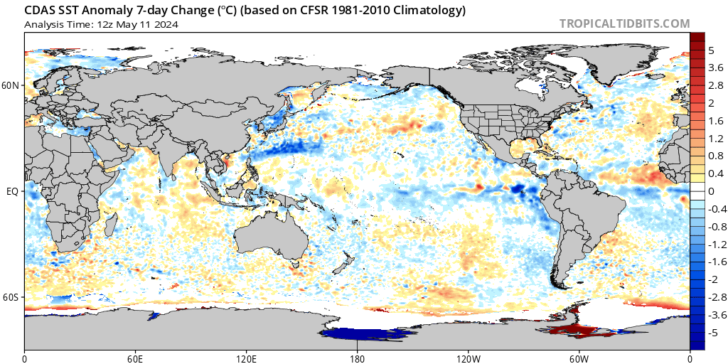
Image

Even though the MDR is cooling, the Subtropics off the East Coast are also cooling. I believe the MDR anomalies usually fluctuate around this time of year due to strong trades and SAL outbreaks causing upwelling. However, the Subtropics off the East Coast should be in a warming trend this time of year, but they are cooling since there has been cold outbreaks moving off the East Coast. Perhaps this could be a factor that stops the subtropics from outperforming the tropics this year, and this also may help the AMO take more of a + appearance as we go into hurricane season. Just throwing in my 2 cents here, obviously SSTs are always fluctuating and The Atlantic may look very different by August and September.
3 likes   
My posts are only my opinions and NOT official forecasts. For official forecasts, consult the National Hurricane Center or the National Weather Service.

Irene 11', Sandy 12', Fay 20’, Isaias 20’, Elsa 21’, Henri 21’, Ida 21’

tolakram
Admin
Admin
Posts: 20009
Age: 62
Joined: Sun Aug 27, 2006 8:23 pm
Location: Florence, KY (name is Mark)

Re: 2020 Indicators: SST's / SAL / MSLP / Steering / Shear / Instability / Sat Images

#414 Postby tolakram » Tue May 05, 2020 4:47 pm

The hype about my post about the hype seems a little over the top. :lol:

I'm talking about some of the tweets. I should have been very clear, I don't think anyone here is hyping, the discussion is good.

My personal view is we have no idea whatsoever, beyond a few slight hints, how bad the season will be.
10 likes   
M a r k
- - - - -
Join us in chat: Storm2K Chatroom Invite. Android and IOS apps also available.

The posts in this forum are NOT official forecasts and should not be used as such. Posts are NOT endorsed by any professional institution or STORM2K.org. For official information and forecasts, please refer to NHC and NWS products.

User avatar
SFLcane
S2K Supporter
S2K Supporter
Posts: 10163
Age: 47
Joined: Sat Jun 05, 2010 1:44 pm
Location: Lake Worth Florida

Re: 2020 Indicators: SST's / SAL / MSLP / Steering / Shear / Instability / Sat Images

#415 Postby SFLcane » Tue May 05, 2020 5:16 pm

weathaguyry wrote:https://www.tropicaltidbits.com/analysis/ocean/cdas-sflux_ssta7diff_global_1.png

Even though the MDR is cooling, the Subtropics off the East Coast are also cooling. I believe the MDR anomalies usually fluctuate around this time of year due to strong trades and SAL outbreaks causing upwelling. However, the Subtropics off the East Coast should be in a warming trend this time of year, but they are cooling since there has been cold outbreaks moving off the East Coast. Perhaps this could be a factor that stops the subtropics from outperforming the tropics this year, and this also may help the AMO take more of a + appearance as we go into hurricane season. Just throwing in my 2 cents here, obviously SSTs are always fluctuating and The Atlantic may look very different by August and September.


The Pacific is heading towards La Niña no doubt about that. Conditions across the Atlantic could be quite favorable to say the least come August.

Edit; after looking at the May euro it’s not as favorable as it looked the previous month for the Atlantic. 1973, 2012 are pretty extreme examples of a la Niña not amounting to much. Just going with the euro which as a whole is usually the best model it’s showing a near average season IF it’s right.
2 likes   

User avatar
SFLcane
S2K Supporter
S2K Supporter
Posts: 10163
Age: 47
Joined: Sat Jun 05, 2010 1:44 pm
Location: Lake Worth Florida

Re: 2020 Indicators: SST's / SAL / MSLP / Steering / Shear / Instability / Sat Images

#416 Postby SFLcane » Wed May 06, 2020 7:13 am

Phil k in his June update will likely account for the cooling in the Atlantic if it persists.
0 likes   

User avatar
cycloneye
Admin
Admin
Posts: 145303
Age: 68
Joined: Thu Oct 10, 2002 10:54 am
Location: San Juan, Puerto Rico

Re: 2020 Indicators: SST's / SAL / MSLP / Steering / Shear / Instability / Sat Images

#417 Postby cycloneye » Wed May 06, 2020 7:24 am

SFLcane wrote:Phil k in his June update will likely account for the cooling in the Atlantic if it persists.


But he wrote this twit on May 4th.

 https://twitter.com/philklotzbach/status/1257340716637925382


0 likes   
Visit the Caribbean-Central America Weather Thread where you can find at first post web cams,radars
and observations from Caribbean basin members Click Here

User avatar
SFLcane
S2K Supporter
S2K Supporter
Posts: 10163
Age: 47
Joined: Sat Jun 05, 2010 1:44 pm
Location: Lake Worth Florida

Re: 2020 Indicators: SST's / SAL / MSLP / Steering / Shear / Instability / Sat Images

#418 Postby SFLcane » Wed May 06, 2020 8:16 am

cycloneye wrote:
SFLcane wrote:Phil k in his June update will likely account for the cooling in the Atlantic if it persists.


But he wrote this twit on May 4th.

https://twitter.com/philklotzbach/status/1257340716637925382


Hi Luis, The Euro cools from that look.
0 likes   

TheStormExpert

Re: 2020 Indicators: SST's / SAL / MSLP / Steering / Shear / Instability / Sat Images

#419 Postby TheStormExpert » Wed May 06, 2020 8:36 am

Season cancel posts already!? It’s not even June 1st! :roll:
4 likes   

jconsor
Professional-Met
Professional-Met
Posts: 551
Joined: Mon Jun 30, 2008 9:31 pm
Location: Jerusalem, Israel
Contact:

Re: 2020 Indicators: SST's / SAL / MSLP / Steering / Shear / Instability / Sat Images

#420 Postby jconsor » Wed May 06, 2020 8:41 am

ECMWF appears to be too cool for the MDR for May 2020 vs. current SSTs, unless there is a significant cooling rest of May.

Also the SSTs forecast from ECMWF doesn't show much change in most of the MDR from May to Sep. The significant cooling is mainly from the far northern Caribbean into the subtropical Atlantic.

Image
Image
Image
Image
3 likes   


Return to “Talkin' Tropics”

Who is online

Users browsing this forum: Cdenton12, JtSmarts, Kennethb, southmdwatcher and 46 guests