BoB: AMPHAN - Post-Tropical
Moderator: S2k Moderators
-
Yellow Evan

- Professional-Met

- Posts: 16222
- Age: 27
- Joined: Fri Jul 15, 2011 12:48 pm
- Location: Henderson, Nevada/Honolulu, HI
- Contact:
Re: BoB: AMPHAN - Cyclonic Storm
Have no idea why the JTWC is only showing 85 knots. It’s CDO screams upper end Category 5 and the globals continue to hint at such.
2 likes

Re: BoB: AMPHAN - Cyclonic Storm
Crostorm wrote:https://i.postimg.cc/BZ4fnNzh/himawari8-wv-01-B.gif
That looks like a mid-range Tropical Storm, or even on the high end.
0 likes
-
Yellow Evan
- Professional-Met
- Posts: 16222
- Age: 27
- Joined: Fri Jul 15, 2011 12:48 pm
- Location: Henderson, Nevada/Honolulu, HI
- Contact:
Re: BoB: AMPHAN - Cyclonic Storm
Abdullah wrote:Crostorm wrote:https://i.postimg.cc/BZ4fnNzh/himawari8-wv-01-B.gif
That looks like a mid-range Tropical Storm, or even on the high end.
ASCAT shows 45 knots so probably 50 knots. It's actual presentation is that of, without microwave, something I'd suspect would be on the brink of becoming a hurricane.

3 likes
-
Yellow Evan
- Professional-Met
- Posts: 16222
- Age: 27
- Joined: Fri Jul 15, 2011 12:48 pm
- Location: Henderson, Nevada/Honolulu, HI
- Contact:
Re: BoB: AMPHAN - Cyclonic Storm
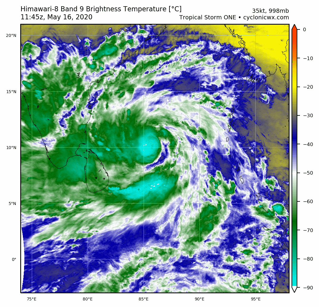
----- Current Analysis -----
Date : 16 MAY 2020 Time : 164500 UTC
Lat : 10:44:50 N Lon : 85:59:53 E
CI# /Pressure/ Vmax
3.4 / 993.1mb/ 53.0kt
Final T# Adj T# Raw T#
3.4 3.3 4.0
Center Temp : -86.8C Cloud Region Temp : -86.3C
Scene Type : UNIFORM CDO CLOUD REGION
Subtropical Adjustment : OFF
Extratropical Adjustment : OFF
Positioning Method : FORECAST INTERPOLATION
Ocean Basin : INDIAN
Dvorak CI > MSLP Conversion Used : CKZ Method
0 likes

Re: BoB: AMPHAN - Cyclonic Storm
Yellow Evan wrote:Have no idea why the JTWC is only showing 85 knots. It’s CDO screams upper end Category 5 and the globals continue to hint at such.
It’s the JTWC tracking something in the NIO, what else would you expect? I’m betting it becomes a Cat 5 but they only say it’s 130-135 kt.
2 likes
Irene '11 Sandy '12 Hermine '16 5/15/2018 Derecho Fay '20 Isaias '20 Elsa '21 Henri '21 Ida '21
I am only a meteorology enthusiast who knows a decent amount about tropical cyclones. Look to the professional mets, the NHC, or your local weather office for the best information.
I am only a meteorology enthusiast who knows a decent amount about tropical cyclones. Look to the professional mets, the NHC, or your local weather office for the best information.
-
Shell Mound
- Category 5

- Posts: 2432
- Age: 33
- Joined: Thu Sep 07, 2017 3:39 pm
- Location: St. Petersburg, FL → Scandinavia
Re: BoB: AMPHAN - Cyclonic Storm
BYG Jacob wrote:UKMET killing 5 or 6 digit figures of people in their runs I see.
This will probably end up killing just that amount of people, based on the synoptic/thermodynamic environment, topography, bathymetry, and population density.
0 likes
CVW / MiamiensisWx / Shell Mound
The posts in this forum are NOT official forecasts and should not be used as such. They are just the opinion of the poster and may or may not be backed by sound meteorological data. They are NOT endorsed by any professional institution or STORM2K. For official information, please refer to products from the NHC and NWS.
Re: BoB: AMPHAN - Cyclonic Storm
aspen wrote:Yellow Evan wrote:Have no idea why the JTWC is only showing 85 knots. It’s CDO screams upper end Category 5 and the globals continue to hint at such.
It’s the JTWC tracking something in the NIO, what else would you expect? I’m betting it becomes a Cat 5 but they only say it’s 130-135 kt.
Why do we use, or even care about the JTWC's unofficial forecasts and not the IMD's official forecasts?
0 likes
-
Yellow Evan
- Professional-Met
- Posts: 16222
- Age: 27
- Joined: Fri Jul 15, 2011 12:48 pm
- Location: Henderson, Nevada/Honolulu, HI
- Contact:
Re: BoB: AMPHAN - Cyclonic Storm
Abdullah wrote:aspen wrote:Yellow Evan wrote:Have no idea why the JTWC is only showing 85 knots. It’s CDO screams upper end Category 5 and the globals continue to hint at such.
It’s the JTWC tracking something in the NIO, what else would you expect? I’m betting it becomes a Cat 5 but they only say it’s 130-135 kt.
Why do we use, or even care about the JTWC's unofficial forecasts and not the IMD's official forecasts?
Neither agency has a good reputation for accuracy on here if I’m being frank though I find IMD’s poor Dvorak analysis and historical reluctance to classify what in my view are clear tropical cyclones worse.
2 likes
-
Yellow Evan
- Professional-Met
- Posts: 16222
- Age: 27
- Joined: Fri Jul 15, 2011 12:48 pm
- Location: Henderson, Nevada/Honolulu, HI
- Contact:
Re: BoB: AMPHAN - Cyclonic Storm
TPIO10 PGTW 161826
A. TROPICAL CYCLONE 01B (E OF INDIA)
B. 16/1745Z
C. 10.91N
D. 86.00E
E. FIVE/GOES-IO
F. T2.5/2.5/D2.5/24HRS STT: S0.0/03HRS
G. IR/EIR
H. REMARKS: 38A/PBO SBC/ANMTN. CNVTN WRAPS .40 ON LOG10 SPIRAL
YIELDING DT OF 2.5.PT AGREES. MET 2.0. DBO DT.
I. ADDITIONAL POSITIONS: NONE
DARLOW
A. TROPICAL CYCLONE 01B (E OF INDIA)
B. 16/1745Z
C. 10.91N
D. 86.00E
E. FIVE/GOES-IO
F. T2.5/2.5/D2.5/24HRS STT: S0.0/03HRS
G. IR/EIR
H. REMARKS: 38A/PBO SBC/ANMTN. CNVTN WRAPS .40 ON LOG10 SPIRAL
YIELDING DT OF 2.5.PT AGREES. MET 2.0. DBO DT.
I. ADDITIONAL POSITIONS: NONE
DARLOW
1 likes
-
Yellow Evan
- Professional-Met
- Posts: 16222
- Age: 27
- Joined: Fri Jul 15, 2011 12:48 pm
- Location: Henderson, Nevada/Honolulu, HI
- Contact:


Re: BoB: AMPHAN - Cyclonic Storm
That looks stronger than when i last checked 3 hours ago for sure
0 likes
Very useful information on the Dvorak Technique --
https://severe.worldweather.wmo.int/TCF ... kBeven.pdf
https://severe.worldweather.wmo.int/TCF ... kBeven.pdf
Re: BoB: AMPHAN - Cyclonic Storm
Yellow Evan wrote:Abdullah wrote:aspen wrote:It’s the JTWC tracking something in the NIO, what else would you expect? I’m betting it becomes a Cat 5 but they only say it’s 130-135 kt.
Why do we use, or even care about the JTWC's unofficial forecasts and not the IMD's official forecasts?
Neither agency has a good reputation for accuracy on here if I’m being frank though I find IMD’s poor Dvorak analysis and historical reluctance to classify what in my view are clear tropical cyclones worse.
The sheer incompetence I’ve seen with both the IMD and the JTWC with certain storms — Hagibis, Bualoi, Halong, Kyarr, and 07A to name a few — really makes me wonder if they’re just being lazy or actually trying to be terrible. It baffles me how official agencies can let something like 07A slide or do horrendous Dvorak analyses that people on this forum can do way better.
Not to say the JTWC doesn’t do stuff right; they did a mostly good job with Vongfong and Harold.
2 likes
Irene '11 Sandy '12 Hermine '16 5/15/2018 Derecho Fay '20 Isaias '20 Elsa '21 Henri '21 Ida '21
I am only a meteorology enthusiast who knows a decent amount about tropical cyclones. Look to the professional mets, the NHC, or your local weather office for the best information.
I am only a meteorology enthusiast who knows a decent amount about tropical cyclones. Look to the professional mets, the NHC, or your local weather office for the best information.

Re: BoB: AMPHAN - Cyclonic Storm
Based on the environment, water temps , depth of the warm waters and the fact this could pass thru virtually untapped waters, this could be a catastrophe indeed. One more thing to note is that the storm is about 3 to 4 days away (5/20/2020) from landfall, and this puts it in a peculiar position and time (3 days before landfall) in which many past storms, in all basins, were at before they struck land at peak intensity. Could this also be the case with Amphan? Hope not, but the fact models keep blowing this thing up is a very ominous thing indeed. I hope everyone in this future monster's path are taking precautions early.
0 likes
Georges '98, Irene '99, Frances '04, Jeanne '04, Katrina '05, Wilma '05, Gustav '08, Isaac '12, Matthew '16, Florence '18, Michael '18, Ian '22
-
Yellow Evan
- Professional-Met
- Posts: 16222
- Age: 27
- Joined: Fri Jul 15, 2011 12:48 pm
- Location: Henderson, Nevada/Honolulu, HI
- Contact:
Re: BoB: AMPHAN - Cyclonic Storm
aspen wrote:Yellow Evan wrote:Abdullah wrote:
Why do we use, or even care about the JTWC's unofficial forecasts and not the IMD's official forecasts?
Neither agency has a good reputation for accuracy on here if I’m being frank though I find IMD’s poor Dvorak analysis and historical reluctance to classify what in my view are clear tropical cyclones worse.
The sheer incompetence I’ve seen with both the IMD and the JTWC with certain storms — Hagibis, Bualoi, Halong, Kyarr, and 07A to name a few — really makes me wonder if they’re just being lazy or actually trying to be terrible. It baffles me how official agencies can let something like 07A slide or do horrendous Dvorak analyses that people on this forum can do way better.
Not to say the JTWC doesn’t do stuff right; they did a mostly good job with Vongfong and Harold.
I've long suspected that they are just new and didn't grow up doing Dvorak like many of this forum have.
0 likes
-
BYG Jacob
Re: BoB: AMPHAN - Cyclonic Storm
Shell Mound wrote:BYG Jacob wrote:UKMET killing 5 or 6 digit figures of people in their runs I see.
This will probably end up killing just that amount of people, based on the synoptic/thermodynamic environment, topography, bathymetry, and population density.
The Ganges delta is just about the worst landfall spot for an intense storm to make.
1 likes
Re: BoB: AMPHAN - Cyclonic Storm
Microwave pass from 15z shows an incomplete tiny eyewall: https://rammb-data.cira.colostate.edu/t ... 161522.gif
0 likes
Irene '11 Sandy '12 Hermine '16 5/15/2018 Derecho Fay '20 Isaias '20 Elsa '21 Henri '21 Ida '21
I am only a meteorology enthusiast who knows a decent amount about tropical cyclones. Look to the professional mets, the NHC, or your local weather office for the best information.
I am only a meteorology enthusiast who knows a decent amount about tropical cyclones. Look to the professional mets, the NHC, or your local weather office for the best information.
-
1900hurricane

- Category 5
- Posts: 6063
- Age: 34
- Joined: Fri Feb 06, 2015 12:04 pm
- Location: Houston, TX
- Contact:
Re: BoB: AMPHAN - Cyclonic Storm
Yellow Evan wrote:Abdullah wrote:Crostorm wrote:https://i.postimg.cc/BZ4fnNzh/himawari8-wv-01-B.gif
That looks like a mid-range Tropical Storm, or even on the high end.
ASCAT shows 45 knots so probably 50 knots. It's actual presentation is that of, without microwave, something I'd suspect would be on the brink of becoming a hurricane.
https://i.imgur.com/LxI5qLi.jpg
Chou, Wu, & Lin actually suggest that the ASCAT low bias is even higher at that level. When cross-compared with dropsonde data, a 23 m/s (45 kt) ASCAT vector actually best correlates to a 30 m/s (58 kt) intensity.

3 likes
Contract Meteorologist. TAMU & MSST. Fiercely authentic, one of a kind. We are all given free will, so choose a life meant to be lived. We are the Masters of our own Stories.
Opinions expressed are mine alone.
Follow me on Twitter at @1900hurricane : Read blogs at https://1900hurricane.wordpress.com/
Opinions expressed are mine alone.
Follow me on Twitter at @1900hurricane : Read blogs at https://1900hurricane.wordpress.com/
Re: BoB: AMPHAN - Cyclonic Storm
aspen wrote:Yellow Evan wrote:Abdullah wrote:
Why do we use, or even care about the JTWC's unofficial forecasts and not the IMD's official forecasts?
Neither agency has a good reputation for accuracy on here if I’m being frank though I find IMD’s poor Dvorak analysis and historical reluctance to classify what in my view are clear tropical cyclones worse.
The sheer incompetence I’ve seen with both the IMD and the JTWC with certain storms — Hagibis, Bualoi, Halong, Kyarr, and 07A to name a few — really makes me wonder if they’re just being lazy or actually trying to be terrible. It baffles me how official agencies can let something like 07A slide or do horrendous Dvorak analyses that people on this forum can do way better.
Not to say the JTWC doesn’t do stuff right; they did a mostly good job with Vongfong and Harold.
I don't think the JTWC is bad, but what started the JTWC making forecasts for the South Asia region too? Why don't the agencies stay in their respective regions?
0 likes
-
Yellow Evan
- Professional-Met
- Posts: 16222
- Age: 27
- Joined: Fri Jul 15, 2011 12:48 pm
- Location: Henderson, Nevada/Honolulu, HI
- Contact:
Re: BoB: AMPHAN - Cyclonic Storm

A good reminder to not take the GFS pressures literally and that inner core dynamics are likely to be the driving force in terms of intensity at its peak.
0 likes
-
Yellow Evan
- Professional-Met
- Posts: 16222
- Age: 27
- Joined: Fri Jul 15, 2011 12:48 pm
- Location: Henderson, Nevada/Honolulu, HI
- Contact:
Re: BoB: AMPHAN - Cyclonic Storm
Abdullah wrote:aspen wrote:Yellow Evan wrote:
Neither agency has a good reputation for accuracy on here if I’m being frank though I find IMD’s poor Dvorak analysis and historical reluctance to classify what in my view are clear tropical cyclones worse.
The sheer incompetence I’ve seen with both the IMD and the JTWC with certain storms — Hagibis, Bualoi, Halong, Kyarr, and 07A to name a few — really makes me wonder if they’re just being lazy or actually trying to be terrible. It baffles me how official agencies can let something like 07A slide or do horrendous Dvorak analyses that people on this forum can do way better.
Not to say the JTWC doesn’t do stuff right; they did a mostly good job with Vongfong and Harold.
I don't think the JTWC is bad, but what started the JTWC making forecasts for the South Asia region too? Why don't the agencies stay in their respective regions?
US has a military presence around the world, not just in the western Pacific so there "home region" is not just the western Pacific.
0 likes
Who is online
Users browsing this forum: No registered users and 11 guests