BoB: AMPHAN - Post-Tropical

Moderator: S2k Moderators

Message
Author
User avatar
Nancy Smar
Category 5
Category 5
Posts: 1081
Age: 24
Joined: Wed Aug 16, 2017 10:03 pm

Re: BoB: AMPHAN - Very Severe Cyclonic Storm

#221 Postby Nancy Smar » Sun May 17, 2020 7:26 pm

TPIO10 PGTW 180015
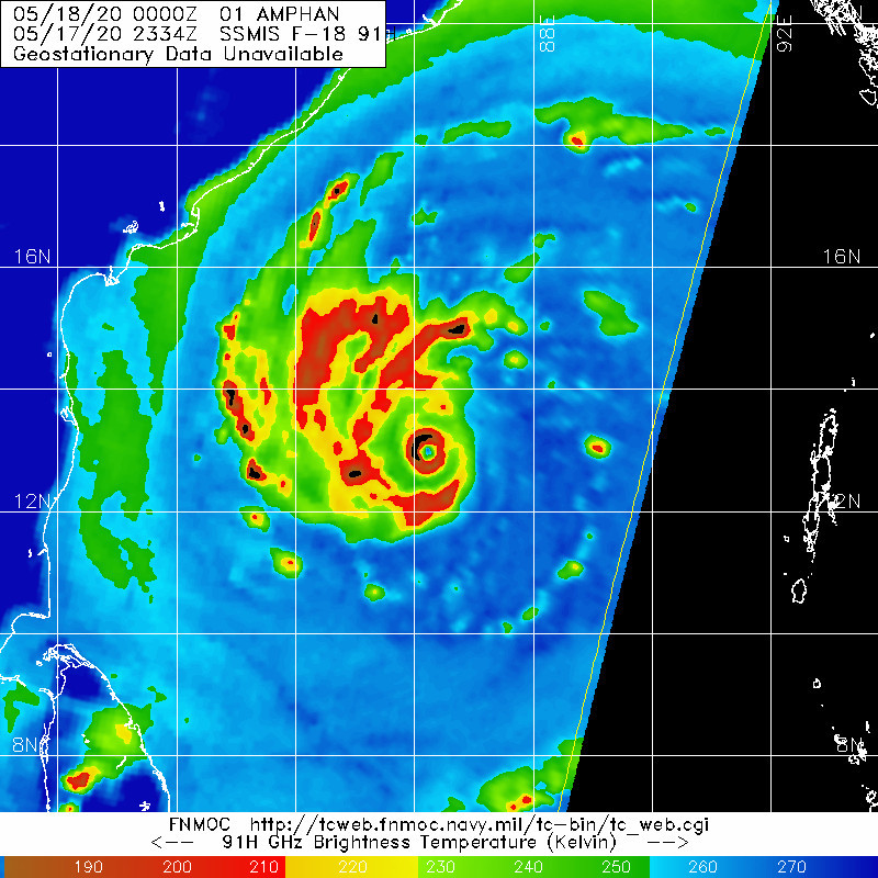
A. TROPICAL CYCLONE 01B (AMPHAN)
B. 17/2345Z
C. 13.18N
D. 86.33E
E. ONE/GOES-IO
F. T7.0/7.0/D4.5/24HRS STT: D0.5/03HRS
G. IR/EIR
H. REMARKS: 05A/PBO . CMG SURR EYE OF DG +0.5 EYE ADJ YIELDS DT OF
7.0, PT 6.5. MET 5.5. DBO DT.
I. ADDITIONAL POSITIONS: NONE
DARLOW
1 likes   

User avatar
Yellow Evan
Professional-Met
Professional-Met
Posts: 16058
Age: 26
Joined: Fri Jul 15, 2011 12:48 pm
Location: Henderson, Nevada/Honolulu, HI
Contact:

Re: BoB: AMPHAN - Very Severe Cyclonic Storm

#222 Postby Yellow Evan » Sun May 17, 2020 7:31 pm

I mean 2345z only has MG from METOSAT8 so not sure what JTWC is looking at with regards to a DG eye since using GEOS-IO. Not impossible that's showing a DG eye and warmer cloud tops though. Of course, I'd also argue the CDG rule should be invoked.
0 likes   

User avatar
Nancy Smar
Category 5
Category 5
Posts: 1081
Age: 24
Joined: Wed Aug 16, 2017 10:03 pm

Re: BoB: AMPHAN - Very Severe Cyclonic Storm

#223 Postby Nancy Smar » Sun May 17, 2020 7:33 pm

01B AMPHAN 200518 0000 13.2N 86.5E IO 130 919
2 likes   

User avatar
Highteeld
Category 5
Category 5
Posts: 2139
Age: 41
Joined: Tue Jan 30, 2018 9:10 pm
Location: Chicago

Re: BoB: AMPHAN - Very Severe Cyclonic Storm

#224 Postby Highteeld » Sun May 17, 2020 7:35 pm

Pretty remarkable CDO; colder than Haiyan's.
0 likes   
Very useful information on the Dvorak Technique --

https://severe.worldweather.wmo.int/TCF ... kBeven.pdf

MarioProtVI
Category 4
Category 4
Posts: 932
Age: 23
Joined: Sun Sep 29, 2019 7:33 pm
Location: New Jersey

Re: BoB: AMPHAN - Very Severe Cyclonic Storm

#225 Postby MarioProtVI » Sun May 17, 2020 7:37 pm

Amphan’s gone from 85/975 to 150/919 in 12 hours...when was the last time we saw this rate of explosive intensification this fast? On a roll rn to Cat 5 when that eye fully clears..
0 likes   

User avatar
Yellow Evan
Professional-Met
Professional-Met
Posts: 16058
Age: 26
Joined: Fri Jul 15, 2011 12:48 pm
Location: Henderson, Nevada/Honolulu, HI
Contact:

Re: BoB: AMPHAN - Very Severe Cyclonic Storm

#226 Postby Yellow Evan » Sun May 17, 2020 7:38 pm

2020MAY17 191500 4.4 972.2 74.6 4.4 5.4 6.7 1.7T/6hr OFF OFF OFF OFF -55.03 -86.28 EYE -99 IR -15.5 12.81 -86.57 ARCHER MSG1 53.4
2020MAY17 194500 4.5 970.5 77.0 4.5 5.4 6.7 1.7T/6hr OFF OFF OFF OFF -57.53 -86.76 EYE -99 IR -15.5 12.78 -86.50 ARCHER MSG1 53.3
2020MAY17 201500 4.7 966.7 82.2 4.7 5.4 6.7 1.7T/6hr OFF OFF OFF OFF -59.40 -86.67 EYE -99 IR -15.5 12.80 -86.60 ARCHER MSG1 53.4
2020MAY17 204500 4.9 962.7 87.4 4.9 5.4 6.8 1.7T/6hr OFF OFF OFF OFF -52.64 -86.91 EYE -99 IR -15.5 12.90 -86.57 ARCHER MSG1 53.4
2020MAY17 211500 5.1 958.8 92.4 5.1 5.4 6.8 1.7T/6hr OFF OFF OFF OFF -53.99 -86.93 EYE -99 IR -15.5 12.90 -86.58 ARCHER MSG1 53.4
2020MAY17 214500 5.2 956.8 94.8 5.2 5.4 6.7 1.7T/6hr OFF OFF OFF OFF -54.33 -86.10 EYE -99 IR -15.5 12.97 -86.60 FCST MSG1 53.5
2020MAY17 221500 5.4 952.9 99.6 5.4 5.5 6.8 1.7T/6hr OFF OFF OFF OFF -48.15 -85.62 EYE -99 IR -15.5 13.02 -86.58 ARCHER MSG1 53.5
2020MAY17 224500 5.4 952.9 99.6 5.4 5.5 6.9 1.7T/6hr OFF OFF OFF OFF -42.86 -86.06 EYE 8 IR -15.5 13.07 -86.53 ARCHER MSG1 53.4
2020MAY17 230000 5.4 952.8 99.6 5.4 5.6 6.8 1.7T/6hr OFF OFF OFF OFF -46.64 -85.94 EYE -99 IR -15.5 13.12 -86.59 ARCHER MSG1 53.5
2020MAY17 234500 5.4 952.8 99.6 5.4 5.6 6.8 1.7T/6hr OFF OFF OFF OFF -51.98 -86.49 EYE -99 IR -15.5 13.22 -86.49 ARCHER MSG1 53.4
Utilizing history file /data2/misc/ADTV9.0/scripts/history/01B.ODT
Successfully completed listing
0 likes   

User avatar
aspen
Category 5
Category 5
Posts: 8812
Joined: Sat Oct 12, 2019 7:10 pm
Location: Connecticut, USA

Re: BoB: AMPHAN - Very Severe Cyclonic Storm

#227 Postby aspen » Sun May 17, 2020 7:43 pm

Highteeld wrote:Pretty remarkable CDO; colder than Haiyan's.

Whenever we have to compare something to Haiyan, you know it’s the real deal.
0 likes   
Irene '11 Sandy '12 Hermine '16 5/15/2018 Derecho Fay '20 Isaias '20 Elsa '21 Henri '21 Ida '21

I am only a meteorology enthusiast who knows a decent amount about tropical cyclones. Look to the professional mets, the NHC, or your local weather office for the best information.

User avatar
Highteeld
Category 5
Category 5
Posts: 2139
Age: 41
Joined: Tue Jan 30, 2018 9:10 pm
Location: Chicago

Re: BoB: AMPHAN - Very Severe Cyclonic Storm

#228 Postby Highteeld » Sun May 17, 2020 7:45 pm

MarioProtVI wrote:Amphan’s gone from 85/975 to 150/919 in 12 hours...when was the last time we saw this rate of explosive intensification this fast? On a roll rn to Cat 5 when that eye fully clears..

Hagabis last year likely intensified faster than Amphan; so fast that the JTWC was unable to keep up and they missed the peak!
1 likes   
Very useful information on the Dvorak Technique --

https://severe.worldweather.wmo.int/TCF ... kBeven.pdf

User avatar
Hayabusa
Category 5
Category 5
Posts: 4245
Joined: Sun Sep 16, 2018 1:05 pm

Re: BoB: AMPHAN - Very Severe Cyclonic Storm

#229 Postby Hayabusa » Sun May 17, 2020 7:47 pm

Nancy Smar wrote:01B AMPHAN 200518 0000 13.2N 86.5E IO 130 919


Super Typhoon Amphan
0 likes   
ヤンデレ女が寝取られるているのを見たい!!!
ECMWF ensemble NWPAC plots: https://ecmwfensnwpac.imgbb.com/
Multimodel NWPAC plots: https://multimodelnwpac.imgbb.com/
GFS Ensemble NWPAC plots (16 & 35 day forecast): https://gefsnwpac.imgbb.com/
Plots updated automatically

User avatar
TheProfessor
Professional-Met
Professional-Met
Posts: 3506
Age: 28
Joined: Tue Dec 03, 2013 10:56 am
Location: Wichita, Kansas

Re: BoB: AMPHAN - Very Severe Cyclonic Storm

#230 Postby TheProfessor » Sun May 17, 2020 7:52 pm

This has been my first time watching an IO storm. It's been a bittersweet treat due to the fact of knowing that it's going to be catastrophic for the areas it's moving towards.
2 likes   
An alumnus of The Ohio State University.

Your local National Weather Service office is your best source for weather information.

MarioProtVI
Category 4
Category 4
Posts: 932
Age: 23
Joined: Sun Sep 29, 2019 7:33 pm
Location: New Jersey

Re: BoB: AMPHAN - Very Severe Cyclonic Storm

#231 Postby MarioProtVI » Sun May 17, 2020 8:00 pm

IMD is really failing to keep up or they just absolutely suck at estimating the intensity. Apparently they’re calling the increasingly well-defined eye “ragged”. This sort of issue sound familiar to y’all?
1 likes   

User avatar
Nancy Smar
Category 5
Category 5
Posts: 1081
Age: 24
Joined: Wed Aug 16, 2017 10:03 pm

Re: BoB: AMPHAN - Very Severe Cyclonic Storm

#232 Postby Nancy Smar » Sun May 17, 2020 8:06 pm

ESCS ‘AMPHAN’over central parts of South BoB near lat12.9°N and long 86.4°E, CENTRAL PARTS OF BOB, CYCLONE ALERT FOR WEST BENGAL AND NORTH ODISHA COASTS.
0 likes   

User avatar
Yellow Evan
Professional-Met
Professional-Met
Posts: 16058
Age: 26
Joined: Fri Jul 15, 2011 12:48 pm
Location: Henderson, Nevada/Honolulu, HI
Contact:

Re: BoB: AMPHAN - Very Severe Cyclonic Storm

#233 Postby Yellow Evan » Sun May 17, 2020 8:06 pm

Image
0 likes   

User avatar
aspen
Category 5
Category 5
Posts: 8812
Joined: Sat Oct 12, 2019 7:10 pm
Location: Connecticut, USA

Re: BoB: AMPHAN - Very Severe Cyclonic Storm

#234 Postby aspen » Sun May 17, 2020 8:08 pm

A secondary eyewall is trying to form around the tiny, tight inner one. Will an EWRC start to take hold within the next 12 hours, or will that bit of shear from the east delay it?
Image
0 likes   
Irene '11 Sandy '12 Hermine '16 5/15/2018 Derecho Fay '20 Isaias '20 Elsa '21 Henri '21 Ida '21

I am only a meteorology enthusiast who knows a decent amount about tropical cyclones. Look to the professional mets, the NHC, or your local weather office for the best information.

Abdullah
Category 1
Category 1
Posts: 379
Joined: Sat Sep 08, 2018 4:28 pm
Location: Miramar, FL

Re: BoB: AMPHAN - Very Severe Cyclonic Storm

#235 Postby Abdullah » Sun May 17, 2020 8:20 pm

MarioProtVI wrote:IMD is really failing to keep up or they just absolutely suck at estimating the intensity. Apparently they’re calling the increasingly well-defined eye “ragged”. This sort of issue sound familiar to y’all?


They're literally going to kill people.
0 likes   

User avatar
aspen
Category 5
Category 5
Posts: 8812
Joined: Sat Oct 12, 2019 7:10 pm
Location: Connecticut, USA

Re: BoB: AMPHAN - Very Severe Cyclonic Storm

#236 Postby aspen » Sun May 17, 2020 8:22 pm

MarioProtVI wrote:IMD is really failing to keep up or they just absolutely suck at estimating the intensity. Apparently they’re calling the increasingly well-defined eye “ragged”. This sort of issue sound familiar to y’all?

When Amphan’s eye is opened up and it skyrockets you 140-150+ kt, the IMD is going to say something dumb like suggesting it’s still a Cat 3 with a W ring.
0 likes   
Irene '11 Sandy '12 Hermine '16 5/15/2018 Derecho Fay '20 Isaias '20 Elsa '21 Henri '21 Ida '21

I am only a meteorology enthusiast who knows a decent amount about tropical cyclones. Look to the professional mets, the NHC, or your local weather office for the best information.

CrazyC83
Professional-Met
Professional-Met
Posts: 34001
Joined: Tue Mar 07, 2006 11:57 pm
Location: Deep South, for the first time!

Re: BoB: AMPHAN - Very Severe Cyclonic Storm

#237 Postby CrazyC83 » Sun May 17, 2020 8:23 pm

aspen wrote:A secondary eyewall is trying to form around the tiny, tight inner one. Will an EWRC start to take hold within the next 12 hours, or will that bit of shear from the east delay it?
https://rammb-data.cira.colostate.edu/tc_realtime/products/storms/2020io01/amsusr89/2020io01_amsusr89_202005172307.gif


Shear can delay or disrupt formative eyewall cycles too, as we saw with Hurricane Michael.

130 kt seems reasonable, although I think the pressure is probably more like 935 mb.
1 likes   

User avatar
aspen
Category 5
Category 5
Posts: 8812
Joined: Sat Oct 12, 2019 7:10 pm
Location: Connecticut, USA

Re: BoB: AMPHAN - Very Severe Cyclonic Storm

#238 Postby aspen » Sun May 17, 2020 8:29 pm

CrazyC83 wrote:
aspen wrote:A secondary eyewall is trying to form around the tiny, tight inner one. Will an EWRC start to take hold within the next 12 hours, or will that bit of shear from the east delay it?
https://rammb-data.cira.colostate.edu/tc_realtime/products/storms/2020io01/amsusr89/2020io01_amsusr89_202005172307.gif


Shear can delay or disrupt formative eyewall cycles too, as we saw with Hurricane Michael.

130 kt seems reasonable, although I think the pressure is probably more like 935 mb.

Didn’t the same thing happen with Dorian? I thought I heard its EWRC was prevented by a bit of shear, allowing it to bomb out before landfall.
0 likes   
Irene '11 Sandy '12 Hermine '16 5/15/2018 Derecho Fay '20 Isaias '20 Elsa '21 Henri '21 Ida '21

I am only a meteorology enthusiast who knows a decent amount about tropical cyclones. Look to the professional mets, the NHC, or your local weather office for the best information.

User avatar
Hypercane_Kyle
Category 5
Category 5
Posts: 3344
Joined: Sat Mar 07, 2015 7:58 pm
Location: Cape Canaveral, FL

Re: BoB: AMPHAN - Extremely Severe Cyclonic Storm

#239 Postby Hypercane_Kyle » Sun May 17, 2020 8:37 pm

Eye temps warming again.
0 likes   
My posts are my own personal opinion, defer to the National Hurricane Center (NHC) and other NOAA products for decision making during hurricane season.

User avatar
Hypercane_Kyle
Category 5
Category 5
Posts: 3344
Joined: Sat Mar 07, 2015 7:58 pm
Location: Cape Canaveral, FL

Re: BoB: AMPHAN - Very Severe Cyclonic Storm

#240 Postby Hypercane_Kyle » Sun May 17, 2020 8:41 pm

aspen wrote:
MarioProtVI wrote:IMD is really failing to keep up or they just absolutely suck at estimating the intensity. Apparently they’re calling the increasingly well-defined eye “ragged”. This sort of issue sound familiar to y’all?

When Amphan’s eye is opened up and it skyrockets you 140-150+ kt, the IMD is going to say something dumb like suggesting it’s still a Cat 3 with a W ring.


A little off-topic, but I've always believed there's a political aspect that pressures the IMD to undervalue the intensity of powerful cyclones in order to keep the chaos to a minimum. There's no way the IMD forecasters are as incompetent as some of their past intensity evaluations would lead one to believe.
3 likes   
My posts are my own personal opinion, defer to the National Hurricane Center (NHC) and other NOAA products for decision making during hurricane season.


Return to “2020”

Who is online

Users browsing this forum: No registered users and 40 guests