2020 Indicators: SST's / SAL / MSLP / Steering / Shear / Instability / Sat Images
Moderator: S2k Moderators
Forum rules

The posts in this forum are NOT official forecasts and should not be used as such. They are just the opinion of the poster and may or may not be backed by sound meteorological data. They are NOT endorsed by any professional institution or STORM2K. For official information, please refer to products from the National Hurricane Center and National Weather Service.
-
TheStormExpert
Re: 2020 Indicators: SST's / SAL / MSLP / Steering / Shear / Instability / Sat Images
0 likes
-
Shell Mound
- Category 5

- Posts: 2432
- Age: 33
- Joined: Thu Sep 07, 2017 3:39 pm
- Location: St. Petersburg, FL → Scandinavia
Re: 2020 Indicators: SST's / SAL / MSLP / Steering / Shear / Instability / Sat Images
The current track of Arthur looks quite similar to that of TD Three in 2019. Note that Arthur developed and is curving well to the south and east of where Alex was in 2004. If anything, Arthur is curving eastward even more than TD Three of 2019, based on comparison between each’s trajectory. The main theme is that the early signs are suggesting a season with very few landfalls and a lot of systems OTS, regardless of how many systems form. Florida, especially Southeast Florida, definitely looks to be much safer than average, while the rest of the U.S. and Caribbean look to be reasonably safer than average. Chances of a major-hurricane landfall are going to be quite low in all of these areas. Note that this is not an official forecast; please consult accredited meteorologists for those.
0 likes
CVW / MiamiensisWx / Shell Mound
The posts in this forum are NOT official forecasts and should not be used as such. They are just the opinion of the poster and may or may not be backed by sound meteorological data. They are NOT endorsed by any professional institution or STORM2K. For official information, please refer to products from the NHC and NWS.
-
TheStormExpert
Re: 2020 Indicators: SST's / SAL / MSLP / Steering / Shear / Instability / Sat Images
Shell Mound wrote:The current track of Arthur looks quite similar to that of TD Three in 2019. Note that Arthur developed and is curving well to the south and east of where Alex was in 2004. If anything, Arthur is curving eastward even more than TD Three of 2019, based on comparison between each’s trajectory. The main theme is that the early signs are suggesting a season with very few landfalls and a lot of systems OTS, regardless of how many systems form. Florida, especially Southeast Florida, definitely looks to be much safer than average, while the rest of the U.S. and Caribbean look to be reasonably safer than average. Chances of a major-hurricane landfall are going to be quite low in all of these areas. Note that this is not an official forecast; please consult accredited meteorologists for those.
What are you talking about!? TD #3 last year formed in The Bahamas and was very short-lived and dissipated right off the East-Central FL coast. As for Hurricane Alex in 2004, the tracks are pretty darn similar.
3 likes
-
SFLcane

- S2K Supporter

- Posts: 10281
- Age: 48
- Joined: Sat Jun 05, 2010 1:44 pm
- Location: Lake Worth Florida
Re: 2020 Indicators: SST's / SAL / MSLP / Steering / Shear / Instability / Sat Images
This cooling in the MDR is no bueno for those wanting an active season. Obviously could easily warm by August but we could easily end with a season like 2016.

2 likes
-
toad strangler

- S2K Supporter
- Posts: 4546
- Joined: Sun Jul 28, 2013 3:09 pm
- Location: Earth
- Contact:
Re: 2020 Indicators: SST's / SAL / MSLP / Steering / Shear / Instability / Sat Images
SFLcane wrote:This cooling in the MDR is no bueno for those wanting an active season. Obviously could easily warm by August but we could easily end with a season like 2016.
https://i.imgur.com/j1X1Buo.jpg
Not sure what you mean by "wanting" an active season. I think most here look at the data output and react accordingly no? Anyway, the current negative anomalies shown in the MDR shouldn't do much to stop the amount of waves making the trek westward. I'm not a huge believer in slightly cooler SST's putting the lid on wave activity. We'll see!
4 likes
My Weather Station
https://www.wunderground.com/dashboard/pws/KFLPORTS603
https://www.wunderground.com/dashboard/pws/KFLPORTS603
-
CyclonicFury

- Category 5
- Posts: 2033
- Age: 27
- Joined: Sun Jul 02, 2017 12:32 pm
- Location: NC
- Contact:
Re: 2020 Indicators: SST's / SAL / MSLP / Steering / Shear / Instability / Sat Images
Looks like June will probably have a favorable velocity potential anomaly pattern for more activity.
https://twitter.com/BenNollWeather/status/1262046467658616833
https://twitter.com/BenNollWeather/status/1262046467658616833
0 likes
NCSU B.S. in Meteorology Class of 2021. Tropical weather blogger at http://www.cyclonicfury.com. My forecasts and thoughts are NOT official, for official forecasts please consult the National Hurricane Center.

Re: 2020 Indicators: SST's / SAL / MSLP / Steering / Shear / Instability / Sat Images
toad strangler wrote:SFLcane wrote:This cooling in the MDR is no bueno for those wanting an active season. Obviously could easily warm by August but we could easily end with a season like 2016.
https://i.imgur.com/j1X1Buo.jpg
Not sure what you mean by "wanting" an active season. I think most here look at the data output and react accordingly no? Anyway, the current negative anomalies shown in the MDR shouldn't do much to stop the amount of waves making the trek westward. I'm not a huge believer in slightly cooler SST's putting the lid on wave activity. We'll see!
I take no issue whether people want or don't want an active season. Most here are fascinated and engaged with the dynamics and processes of tropical cyclones. I certainly am. Having said that, I do not believe that somewhat low MDR anomalies have that much of an impact to whether or not the season might be over-active or not. Where occurring, I see anomalous high SST's playing a potential factor suggesting an increased risk of near term rapid intensification for those potentially within a several day window of being hit. In terms of over-all numbers it's reasonable that "low" MDR SST's could lesson the number of MDR tropical cyclones that develop within that anomalous region (perhaps east of 50W?). The flip side to that scenario offers the other possibility that those same tropical disturbances not developing farther east might continue to march westward until generally better overall conditions (SST's, surface pressures, moisture within the vertical column, vertical wind shear) perhaps exist. That net result might suggest a greater all around risk to the Greater Antilles, W. Caribbean and the U.S. due to a fewer number of better developed tropical cyclones re-curving well east of 60W. All other dynamic factors aside, the only reason that I'd assume that SST anomalies alone were pointing toward an under-active to normal season at best would be if those anomalies extended throughout the MDR, the Caribbean, and the GOM.
9 likes
Andy D
(For official information, please refer to the NHC and NWS products.)
(For official information, please refer to the NHC and NWS products.)
Re: 2020 Indicators: SST's / SAL / MSLP / Steering / Shear / Instability / Sat Images
CyclonicFury wrote:Looks like June will probably have a favorable velocity potential anomaly pattern for more activity.
https://twitter.com/BenNollWeather/status/1262046467658616833
In spite of June not typically prolific month for activity, this would fit climo perfectly well. If we were to have a couple of tropical storms in June, this certainly suggests that increased possibility. All eyes on the GOM and W. Caribbean.
1 likes
Andy D
(For official information, please refer to the NHC and NWS products.)
(For official information, please refer to the NHC and NWS products.)

Re: 2020 Indicators: SST's / SAL / MSLP / Steering / Shear / Instability / Sat Images
My biggest concern, looking at those water temps and current trends is that we could see waves come off Africa and struggle until they get closer to the Leewards, then encounter warmer waters and more favorable conditions. Once that happens, we could see lots of activity blowing up near the Islands or Caribbean with future tracks into the Islands or the GOM/ Southeast US. It would actually be better to see a big MDR season because this would increase the odds that most storms go OTS. Unfortunately this season could behave more like 2004/2005, 2008, and 2017. This is just my take, of course. Lets see how things trend by August, when the meat of the season begins!
7 likes
Georges '98, Irene '99, Frances '04, Jeanne '04, Katrina '05, Wilma '05, Gustav '08, Isaac '12, Matthew '16, Florence '18, Michael '18, Ian '22
-
Shell Mound
- Category 5
- Posts: 2432
- Age: 33
- Joined: Thu Sep 07, 2017 3:39 pm
- Location: St. Petersburg, FL → Scandinavia
Re: 2020 Indicators: SST's / SAL / MSLP / Steering / Shear / Instability / Sat Images
FireRat wrote:My biggest concern, looking at those water temps and current trends is that we could see waves come off Africa and struggle until they get closer to the Leewards, then encounter warmer waters and more favorable conditions. Once that happens, we could see lots of activity blowing up near the Islands or Caribbean with future tracks into the Islands or the GOM/ Southeast US. It would actually be better to see a big MDR season because this would increase the odds that most storms go OTS. Unfortunately this season could behave more like 2004/2005, 2008, and 2017. This is just my take, of course. Lets see how things trend by August, when the meat of the season begins!
Years with a lot of “homegrown” storms are more the exception than the norm, even during -AMO regimes. Historically, based on HURDAT2 data back to 1851, more than three-fourths of all major hurricanes (Category-3+) to strike the mainland U.S. first developed in the MDR. 2005 was unusual not just in terms of overall “homegrown” activity—especially relative to the inactive MDR, itself highly unusual in a hyperactive season—but also in terms of the fact that the U.S. experienced four major-hurricane landfalls in one season, all of which originated from “homegrown” development. People might ask, “But what about the 1935 hurricane? Camille? Andrew? Michael?” While three of those four (Andrew originated in the MDR) began as “homegrown” systems, the overall sample size of Cat-5 landfalls is tiny. So overall, even though a lower proportion of MDR storms end up striking the U.S. due to eastward displacement of formation, most of the known major hurricane hits since 1851 have been attributable to MDR storms.
0 likes
CVW / MiamiensisWx / Shell Mound
The posts in this forum are NOT official forecasts and should not be used as such. They are just the opinion of the poster and may or may not be backed by sound meteorological data. They are NOT endorsed by any professional institution or STORM2K. For official information, please refer to products from the NHC and NWS.
-
cycloneye

- Admin

- Posts: 149425
- Age: 69
- Joined: Thu Oct 10, 2002 10:54 am
- Location: San Juan, Puerto Rico
Re: 2020 Indicators: SST's / SAL / MSLP / Steering / Shear / Instability / Sat Images
2 likes
Visit the Caribbean-Central America Weather Thread where you can find at first post web cams,radars
and observations from Caribbean basin members Click Here
and observations from Caribbean basin members Click Here
-
cycloneye
- Admin
- Posts: 149425
- Age: 69
- Joined: Thu Oct 10, 2002 10:54 am
- Location: San Juan, Puerto Rico
Re: 2020 Indicators: SST's / SAL / MSLP / Steering / Shear / Instability / Sat Images
1 likes
Visit the Caribbean-Central America Weather Thread where you can find at first post web cams,radars
and observations from Caribbean basin members Click Here
and observations from Caribbean basin members Click Here
-
Kingarabian

- S2K Supporter
- Posts: 16359
- Joined: Sat Aug 08, 2009 3:06 am
- Location: Honolulu, Hawaii
Re: 2020 Indicators: SST's / SAL / MSLP / Steering / Shear / Instability / Sat Images
cycloneye wrote:[url]https://twitter.com/BenNollWeather/status/1262046467658616833url]
Comparing this June setup to past active years, 1995 and 2005 had similar setups with no dominant rising motion over the MC. But in July they did. The July forecast will be important in gauging how active this season will be.
4 likes
RIP Kobe Bryant
Re: 2020 Indicators: SST's / SAL / MSLP / Steering / Shear / Instability / Sat Images
Shell Mound wrote:Years with a lot of “homegrown” storms are more the exception than the norm, even during -AMO regimes. Historically, based on HURDAT2 data back to 1851, more than three-fourths of all major hurricanes (Category-3+) to strike the mainland U.S. first developed in the MDR. 2005 was unusual not just in terms of overall “homegrown” activity—especially relative to the inactive MDR, itself highly unusual in a hyperactive season—but also in terms of the fact that the U.S. experienced four major-hurricane landfalls in one season, all of which originated from “homegrown” development. People might ask, “But what about the 1935 hurricane? Camille? Andrew? Michael?” While three of those four (Andrew originated in the MDR) began as “homegrown” systems, the overall sample size of Cat-5 landfalls is tiny. So overall, even though a lower proportion of MDR storms end up striking the U.S. due to eastward displacement of formation, most of the known major hurricane hits since 1851 have been attributable to MDR storms.
Good point Shell, most of the big landfallers formed in the MDR. 2005 was weird in how so many of then waited to get near the islands/ Caribbean to get named. I guess we could say a "big MDR season" would be one in which we get full blown hurricanes in the MDR, like 2010 for instance. Strong canes in the MDR tend to go poleward sooner and miss land more often than not. I do worry this year could be one in which storms do form in the MDR but struggle to become anything more than a TS or Cat 1 until they're just a day or two away from the leewards, then they take off, or even 'pull an Andrew', staying weak until they get near the Bahamas/ Southeast US and then go kaboom.
0 likes
Georges '98, Irene '99, Frances '04, Jeanne '04, Katrina '05, Wilma '05, Gustav '08, Isaac '12, Matthew '16, Florence '18, Michael '18, Ian '22
-
gatorcane

- S2K Supporter
- Posts: 23708
- Age: 48
- Joined: Sun Mar 13, 2005 3:54 pm
- Location: Boca Raton, FL
Re: 2020 Indicators: SST's / SAL / MSLP / Steering / Shear / Instability / Sat Images
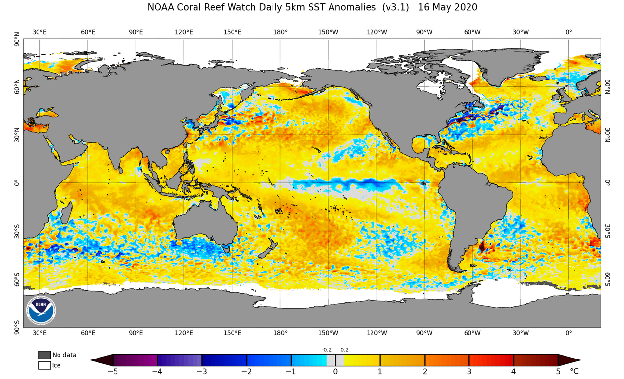
New imagery from NOAA:
2 likes
-
toad strangler
- S2K Supporter
- Posts: 4546
- Joined: Sun Jul 28, 2013 3:09 pm
- Location: Earth
- Contact:
Re: 2020 Indicators: SST's / SAL / MSLP / Steering / Shear / Instability / Sat Images
gatorcane wrote:New imagery from NOAA:
https://i.postimg.cc/qMHSkLP3/ct5km-ssta-v3-1-global-20200516.png
Yeah, there are negligible negative anomalies in the MDR there. Not that it interests me much at this point. I'm no fan of MDR SST hype. It's the blue wavy stripe out in the Pacific at the equator that speaks volumes.
3 likes
My Weather Station
https://www.wunderground.com/dashboard/pws/KFLPORTS603
https://www.wunderground.com/dashboard/pws/KFLPORTS603
-
USTropics
- Professional-Met

- Posts: 2738
- Joined: Sun Aug 12, 2007 3:45 am
- Location: Florida State University
Re: 2020 Indicators: SST's / SAL / MSLP / Steering / Shear / Instability / Sat Images
Past two runs of the CFS have hinted at a possible tropical system moving northward from the Caribbean first week of June.
12z run

00z run

This is super long range, but the conditions are hinting at the possibility with the large sinking branch enhancing the typical May/June CAG and a passing CCKW. You can find these runs here - https://www.pivotalweather.com/model.ph ... mslp&m=cfs
12z run
00z run
This is super long range, but the conditions are hinting at the possibility with the large sinking branch enhancing the typical May/June CAG and a passing CCKW. You can find these runs here - https://www.pivotalweather.com/model.ph ... mslp&m=cfs
5 likes
-
SFLcane
- S2K Supporter
- Posts: 10281
- Age: 48
- Joined: Sat Jun 05, 2010 1:44 pm
- Location: Lake Worth Florida
Re: 2020 Indicators: SST's / SAL / MSLP / Steering / Shear / Instability / Sat Images
USTropics wrote:Past two runs of the CFS have hinted at a possible tropical system moving northward from the Caribbean first week of June.
12z run
https://i.imgur.com/OSBQIS7.png
00z run
https://i.imgur.com/CJCEd5O.png
This is super long range, but the conditions are hinting at the possibility with the large sinking branch enhancing the typical May/June CAG and a passing CCKW. You can find these runs here - https://www.pivotalweather.com/model.ph ... mslp&m=cfs
Will be watching for a reliable model signal. Especially EPS
0 likes
-
SFLcane
- S2K Supporter
- Posts: 10281
- Age: 48
- Joined: Sat Jun 05, 2010 1:44 pm
- Location: Lake Worth Florida
Re: 2020 Indicators: SST's / SAL / MSLP / Steering / Shear / Instability / Sat Images
gatorcane wrote:New imagery from NOAA:
https://i.postimg.cc/qMHSkLP3/ct5km-ssta-v3-1-global-20200516.png
The yellow colorbars are a bit deceptive most of the mdr is basically near average right now.

1 likes
-
TheStormExpert
Re: 2020 Indicators: SST's / SAL / MSLP / Steering / Shear / Instability / Sat Images
A TC in the Western Caribbean or East Pacific seems likely at this point during the first week of June.
https://twitter.com/webberweather/status/1262359461290745857
https://twitter.com/webberweather/status/1262359461290745857
1 likes
Who is online
Users browsing this forum: Google Adsense [Bot], Ulf and 193 guests