
Texas Spring 2020
Moderator: S2k Moderators
Forum rules

The posts in this forum are NOT official forecast and should not be used as such. They are just the opinion of the poster and may or may not be backed by sound meteorological data. They are NOT endorsed by any professional institution or STORM2K.
-
bubba hotep

- S2K Supporter

- Posts: 6014
- Joined: Wed Dec 28, 2016 1:00 am
- Location: Collin County Texas
Re: Texas Spring 2020
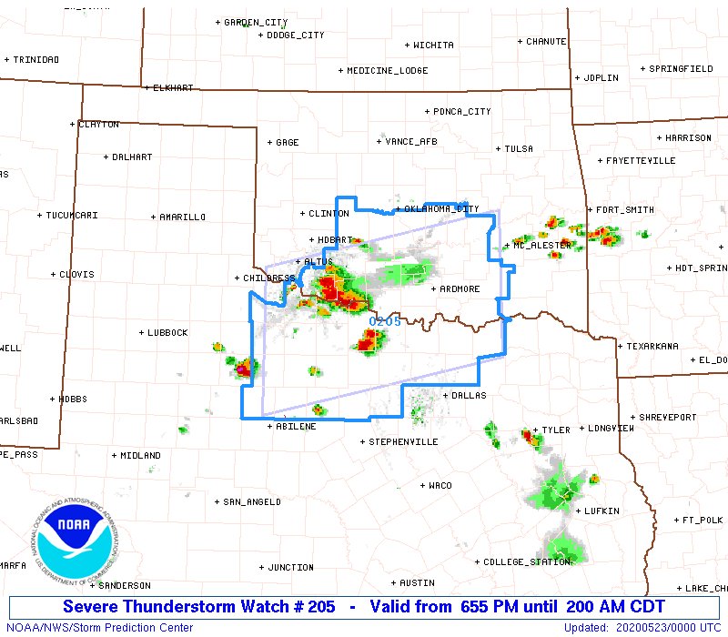
SPC holds steady on the afternoon update, as the outflow boundary from earlier has stalled/washed out.
0 likes
Winter time post are almost exclusively focused on the DFW area.

-
bubba hotep
- S2K Supporter
- Posts: 6014
- Joined: Wed Dec 28, 2016 1:00 am
- Location: Collin County Texas
Re: Texas Spring 2020
Really good update from FWD:
Area Forecast Discussion
National Weather Service Fort Worth TX
303 PM CDT Fri May 22 2020
.SHORT TERM... /Issued 206 PM CDT Fri May 22 2020/
/This afternoon through Saturday/
The overnight Plains convection made a run at North Texas, but
all that remains is a stationary outflow boundary along a line
from Graham to Denton to Bonham. Visible satellite loop shows
gravity waves continue to propagate southward through the cumulus
field into Central Texas, which is a sign of a very strong
capping inversion. This inversion is verified on recent AMDAR
soundings, and we`ll be sending up a balloon within an hour or so
to sample the evolution of the thermodynamic and moisture profile.
Obviously the outflow boundary will be an important mesoscale
feature that will impact not only convective initiation, but also
storm mode and hazards. The backing of winds behind the boundary
has served to increase deep layer shear values notably, resulting
in an environment now supportive of prolonged supercell structures
near and north of the boundary. Meanwhile insolation has been
excellent across the region and low level instability continues to
increase with MLCAPE likely to exceed 3500 J/kg this afternoon.
Given the high instability and prediction of slow eastward right
moving supercells, it is likely that actual supercell motions will
be even more rightward or due south. This is important as it will
impact the storm coverage and evolution. In the last few hours
we`ve seen the HRRR trend toward more supercellular coverage which
is inherently more scattered and therefore suggests less storm
coverage than a multicell cluster or line would have produced.
This more supercellular storm mode is also verified by the WoFs
which is highlighting the supercell threat primarily over the
northwestern zones over the next 4 hours where we have already
seen a few failed attempts at initiation.
Since mature storm motion may tend to take it southward, it may
be a while before storms can initiate farther east (east of
I-35/I-35E and north of I-30) where storm coverage is more in
question. SPC has issued a severe thunderstorm watch for our
northwestern counties through 8 pm. We`ve agreed to watch how
trends evolve before going too far east with a watch. Likewise
we`re concerned that the environment may become more favorable for
tornadoes around sunset, so this watch expiring at 8 pm allows an
assessment of those trends this evening. For now the primary
threat looks like very large hail - possibly up to baseball size -
as we anticipate that we`ll have more sustained supercell
structures than we were earlier. Given the already slow motion of
supercells, would not be surprised to see some nearly stationary
or stalled cells either which could result in localized multi-inch
rains and flash flooding.
By this evening we do expect more coverage of storms and eventually
enough of a cold pool should develop to help send cells
southeastward either as a multicell cluster or broken line. The
evening hours probably represent most of the DFW Metroplex`s best
shot at severe weather. This activity should move south of I-20 by
midnight into Central Texas, but the intensity/coverage should
decrease as the environment becomes increasingly more stable.
There remains a possibility of elevated scattered storms
developing in the overnight hours north of I-20, as this is
advertised by a couple of the models. So we can`t say for sure
that once the first round moves through that northern areas will
be done with the event.
The atmosphere should be worked over for additional storms on
Saturday and have kept PoPS low but advertised lots of cloud
cover. Highs will be in the 80s but it should be very muggy with
light to moderate southerly flow prevailing.
0 likes
Winter time post are almost exclusively focused on the DFW area.
-
bubba hotep
- S2K Supporter
- Posts: 6014
- Joined: Wed Dec 28, 2016 1:00 am
- Location: Collin County Texas
Re: Texas Spring 2020
WacoWx wrote:Everything’s that popping up NW of DFW immediately dissipates.
Yep, lots of orphans so far. Also, it looks like there might be some attempts at CI in the trail of orphan anvil shadows, which is always cool to see.
0 likes
Winter time post are almost exclusively focused on the DFW area.
-
cheezyWXguy

- Category 5

- Posts: 6282
- Joined: Mon Feb 13, 2006 12:29 am
- Location: Dallas, TX
Re: Texas Spring 2020
bubba hotep wrote:WacoWx wrote:Everything’s that popping up NW of DFW immediately dissipates.
Yep, lots of orphans so far. Also, it looks like there might be some attempts at CI in the trail of orphan anvil shadows, which is always cool to see.
Storms finally taking root west of Wichita Falls
2 likes
-
bubba hotep
- S2K Supporter
- Posts: 6014
- Joined: Wed Dec 28, 2016 1:00 am
- Location: Collin County Texas
Re: Texas Spring 2020
Latest HRRR runs move basically everything into Oklahoma leaving N. Texas mostly dry 
1 likes
Winter time post are almost exclusively focused on the DFW area.
-
HockeyTx82
- S2K Supporter
- Posts: 2791
- Joined: Tue Oct 27, 2009 11:17 am
- Location: Ponder, TX
Re: Texas Spring 2020
bubba hotep wrote:Latest HRRR runs move basically everything into Oklahoma leaving N. Texas mostly dry
What is causing this? Second time recently where it seems last minute we get nothing.
0 likes
Don't hold me accountable for anything I post on this forum. Leave the real forecasting up to the professionals.
Location: Ponder, TX (all observation posts are this location unless otherwise noted)
Location: Ponder, TX (all observation posts are this location unless otherwise noted)
-
bubba hotep
- S2K Supporter
- Posts: 6014
- Joined: Wed Dec 28, 2016 1:00 am
- Location: Collin County Texas
Re: Texas Spring 2020
HockeyTx82 wrote:bubba hotep wrote:Latest HRRR runs move basically everything into Oklahoma leaving N. Texas mostly dry
What is causing this? Second time recently where it seems last minute we get nothing.
Today, my guess is weak upper level flow and no truly focused surface feature for storms to fire on. The outflow boundary from this morning appears to have washed out but the best surface convergence was located out West where the remnants of the boundary were still somewhat defined. I actually think it is better for N. Texas that storms are firing farther north, as that could give an opportunity for them to develop a cold pool and eventually surge SE as a cluster or MCS. That is the solution that the 18z 3k NAM appeared to favor.
Also, looking at the 18z sounding from FWD and it still shows a cap in place.
1 likes
Winter time post are almost exclusively focused on the DFW area.

-
cheezyWXguy
- Category 5
- Posts: 6282
- Joined: Mon Feb 13, 2006 12:29 am
- Location: Dallas, TX
Re: Texas Spring 2020
bubba hotep wrote:HockeyTx82 wrote:bubba hotep wrote:Latest HRRR runs move basically everything into Oklahoma leaving N. Texas mostly dry
What is causing this? Second time recently where it seems last minute we get nothing.
Today, my guess is weak upper level flow and no truly focused surface feature for storms to fire on. The outflow boundary from this morning appears to have washed out but the best surface convergence was located out West where the remnants of the boundary were still somewhat defined. I actually think it is better for N. Texas that storms are firing farther north, as that could give an opportunity for them to develop a cold pool and eventually surge SE as a cluster or MCS. That is the solution that the 18z 3k NAM appeared to favor.
Also, looking at the 18z sounding from FWD and it still shows a cap in place.
Latest HRRR seems to be hinting at the NAM solution. More clustering and closer to DFW. I don’t have much faith in the HRRR either way though. The nam has been much more consistent since yesterday, and the HRRR has a bias towards overly discrete activity
0 likes
-
bubba hotep
- S2K Supporter
- Posts: 6014
- Joined: Wed Dec 28, 2016 1:00 am
- Location: Collin County Texas
-
Brent
- S2K Supporter
- Posts: 38737
- Age: 37
- Joined: Sun May 16, 2004 10:30 pm
- Location: Tulsa Oklahoma
- Contact:
Re: Texas Spring 2020
bubba hotep wrote:Latest HRRR runs move basically everything into Oklahoma leaving N. Texas mostly dry
Lol winter flashbacks

0 likes
#neversummer
-
rwfromkansas
- Category 5
- Posts: 3032
- Joined: Sat Aug 27, 2005 12:47 am
- Location: North Fort Worth
-
bubba hotep
- S2K Supporter
- Posts: 6014
- Joined: Wed Dec 28, 2016 1:00 am
- Location: Collin County Texas
Re: Texas Spring 2020
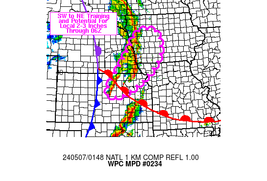
Mesoscale Precipitation Discussion 0234
NWS Weather Prediction Center College Park MD
759 PM EDT Fri May 22 2020
Areas affected...southern OK into north-central TX
Concerning...Heavy rainfall...Flash flooding possible
Valid 222358Z - 230430Z
Summary...The threat for locally heavy rainfall in excess of 3-4
inches will exist from southern OK into north-central TX over the
next few hours. Flash flooding may result, especially where
overlap occurs with locations that picked up 2 to 4+ inches of
rain over the past week.
Discussion...KFDR reflectivity from 2330Z showed a right moving
supercell over Wichita and Cotton counties along the Red River,
while additional thunderstorm growth was occurring upstream over
Tillman County. Visible satellite and radar imagery also showed
the early stages of new development to the south in northwestern
TX, near and north of US-380. The environment over northern TX was
characterized by moderate to high MLCAPE (3000-5000 J/kg) via the
23Z SPC mesoanalysis page and an early look at the 00Z FWD
sounding showed little to no CIN and a PWAT near 1.5 inches.
A mesoscale outflow boundary driven by thunderstorms along the Red
River was serving as a source of lift, supporting renewed
convective development near FDR. The VAD wind plot at KFDR was SSE
at 10-15 kt, but short term forecasts from the RAP indicate
strengthening of the 850 mb flow into the 30-40 kt range just
prior to 06Z. The strengthening of the low level jet will help to
support the advection of rich boundary layer moisture into what
may develop into an MCS near or just south of the Red River.
7-day rainfall anomalies along the western Red River Valley into
portions of north-central TX are 200-400 percent of normal which
may leave the area more susceptible to flash flooding. Rainfall
rates over 2 in/hr will be possible with localized storm totals of
3-5 inches through 04Z or 05Z.
Otto
ATTN...WFO...FWD...OUN...SJT...
ATTN...RFC...ABRFC...LMRFC...WGRFC...NWC...
1 likes
Winter time post are almost exclusively focused on the DFW area.
-
bubba hotep
- S2K Supporter
- Posts: 6014
- Joined: Wed Dec 28, 2016 1:00 am
- Location: Collin County Texas
Re: Texas Spring 2020
00z FWD sounding shows that the cap is mostly gone and CAPE is a jacked up 4,500!
1 likes
Winter time post are almost exclusively focused on the DFW area.
-
bubba hotep
- S2K Supporter
- Posts: 6014
- Joined: Wed Dec 28, 2016 1:00 am
- Location: Collin County Texas
Re: Texas Spring 2020
00z 3k NAM looks pretty good and it eventually sends these storms SE through DFW bringing a good bit of rain to many.

Also, the storm to the east of DFW looked pretty cool earlier and is now putting on a light show.
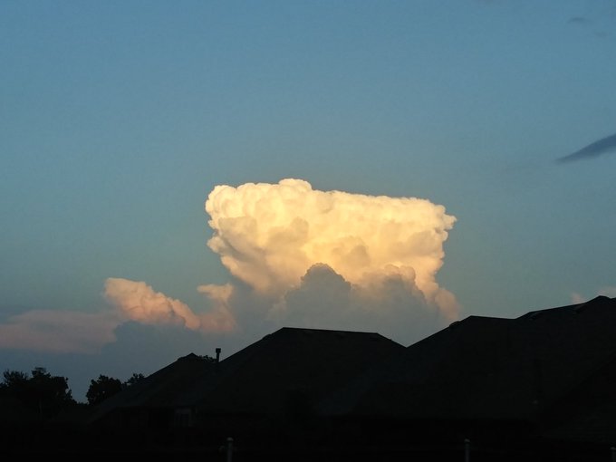
Also, the storm to the east of DFW looked pretty cool earlier and is now putting on a light show.
4 likes
Winter time post are almost exclusively focused on the DFW area.
-
Brent
- S2K Supporter
- Posts: 38737
- Age: 37
- Joined: Sun May 16, 2004 10:30 pm
- Location: Tulsa Oklahoma
- Contact:
Re: Texas Spring 2020
As long as it starts moving south DFW should get something definitely looks to be transitioning towards a line
1 likes
#neversummer
-
Yukon Cornelius
- S2K Supporter
- Posts: 1842
- Age: 42
- Joined: Thu Dec 20, 2012 9:23 pm
- Location: Dean, TX/Westcliffe, CO
Re: Texas Spring 2020
Not my photos. Burkburnett received giant hail this evening. It’s been a wild evening up this way, tornados and huge hail.
 [/url]
 [/url]
[/url][/url]
5 likes
#neversummer
-
HockeyTx82
- S2K Supporter
- Posts: 2791
- Joined: Tue Oct 27, 2009 11:17 am
- Location: Ponder, TX
Re: Texas Spring 2020
Here we go, now it's going SE, just got put under a Severe Thunderstorm Warning off the storm in Bowie. Looks like wind and hail
2 likes
Don't hold me accountable for anything I post on this forum. Leave the real forecasting up to the professionals.
Location: Ponder, TX (all observation posts are this location unless otherwise noted)
Location: Ponder, TX (all observation posts are this location unless otherwise noted)
-
bubba hotep
- S2K Supporter
- Posts: 6014
- Joined: Wed Dec 28, 2016 1:00 am
- Location: Collin County Texas
Re: Texas Spring 2020
Yukon Cornelius wrote:Not my photos. Burkburnett received giant hail this evening. It’s been a wild evening up this way, tornados and huge hail.
https://i.ibb.co/8j8ytHG/88010-EAA-5662-4-D48-A41-A-4-BAB25-A12-DAB.jpg [/url]
https://i.ibb.co/RjC2YdS/FA0-EBD86-AB95-4-A87-89-D5-32-CB2-F31-FE33.jpg [/url]
Holy Cow!
0 likes
Winter time post are almost exclusively focused on the DFW area.
Return to “USA & Caribbean Weather”
Who is online
Users browsing this forum: Stratton23 and 49 guests