2020 Global Model Runs Discussion (Out thru day 16)
Moderator: S2k Moderators
Forum rules

The posts in this forum are NOT official forecasts and should not be used as such. They are just the opinion of the poster and may or may not be backed by sound meteorological data. They are NOT endorsed by any professional institution or STORM2K. For official information, please refer to products from the National Hurricane Center and National Weather Service.
-
TheStormExpert
Re: 2020 Global Model Runs Discussion (Out thru day 16)
Typical case where the Euro shows stronger ridging and the GFS shows weaker ridging or more troughiness. I’d do a compromise of the two and say something forming out of the CAG on the East Pacific side is most likely and it moves north into Central America and dissipates but is a huge rainmaker.
1 likes

Re: 2020 Global Model Runs Discussion (Out thru day 16)
00Z GFS showing a secondary LL vort forming offshore of MX in the Pacific after the primary vort crosses over into the Carib.
Where, when, and how strong this secondary vort evolves will influence the track of the primary vort.
They will interact and create a CCW spin around each other.
The primary vort may or may not be drawn into the Yucatan peninsula.
GFS now evolves this into the whole gyre moving into the GOM.
Where, when, and how strong this secondary vort evolves will influence the track of the primary vort.
They will interact and create a CCW spin around each other.
The primary vort may or may not be drawn into the Yucatan peninsula.
GFS now evolves this into the whole gyre moving into the GOM.
1 likes
Re: 2020 Global Model Runs Discussion (Out thru day 16)
A later move into the GOM appears to be a potential for a stronger storm in the GOM.
355K PV in the clear.
Would fire along a strong dryline with a large infeed of high TPW air.
At this point there is a positive-tilt shortwave swinging over TX.
Timing of it and how this swings into the GOM could set up an area of low-shear for the storm to develop.


355K PV in the clear.
Would fire along a strong dryline with a large infeed of high TPW air.
At this point there is a positive-tilt shortwave swinging over TX.
Timing of it and how this swings into the GOM could set up an area of low-shear for the storm to develop.
0 likes
-
Kingarabian

- S2K Supporter

- Posts: 16360
- Joined: Sat Aug 08, 2009 3:06 am
- Location: Honolulu, Hawaii
Re: 2020 Global Model Runs Discussion (Out thru day 16)
00z Euro had less ridging but still buries it into Mexico.
0 likes
RIP Kobe Bryant
-
SFLcane

- S2K Supporter
- Posts: 10281
- Age: 48
- Joined: Sat Jun 05, 2010 1:44 pm
- Location: Lake Worth Florida
Re: 2020 Global Model Runs Discussion (Out thru day 16)
GCANE wrote:00Z GFS showing a secondary LL vort forming offshore of MX in the Pacific after the primary vort crosses over into the Carib.
Where, when, and how strong this secondary vort evolves will influence the track of the primary vort.
They will interact and create a CCW spin around each other.
The primary vort may or may not be drawn into the Yucatan peninsula.
GFS now evolves this into the whole gyre moving into the GOM.
The GFS is in full fantasycane mode. Notice the Euro has nothing at all.
0 likes
Re: 2020 Global Model Runs Discussion (Out thru day 16)
GFS just can't let go of this.
06Z run keeps it mainly in the Carib.
Stronger storm in the GOM.
One thing for sure, GOM is juiced.

06Z run keeps it mainly in the Carib.
Stronger storm in the GOM.
One thing for sure, GOM is juiced.
1 likes
Re: 2020 Global Model Runs Discussion (Out thru day 16)
Kicker may be a ULL at 28N 64W setting up a nearly ideal poleward outflow channel

1 likes
Re: 2020 Global Model Runs Discussion (Out thru day 16)
Better interaction with the shortwave on this run.
Going negative tilt.

Going negative tilt.
1 likes
-
jconsor
- Professional-Met

- Posts: 580
- Joined: Mon Jun 30, 2008 9:31 pm
- Location: Jerusalem, Israel
- Contact:
Re: 2020 Global Model Runs Discussion (Out thru day 16)
I disagree. If past history of Central American Gyres (CAGs) has taught us anything, it is that while operational and ensemble models are generally decent at showing the formation of CAGs a week or more in advance, the details of tropical cyclone(s) formation and vorticity interactions around the CAG are highly uncertain.
Furthermore, even if the E. Pacific tropical cyclone dies out over Central America, the pattern (upward motion related to a combination of MJO and a Kelvin wave moving from E. Pacific into the W. Atl basin) would favor another TC forming over the W. Caribbean or Bay of Campeche in the first third of Jun. It seems to me (hard to tell exactly) that more than half of the tropical cyclones that EPS members show in early Jun in the W. Caribbean, Bay of Campeche and GOM are not from the original E. Pacific system.


Furthermore, even if the E. Pacific tropical cyclone dies out over Central America, the pattern (upward motion related to a combination of MJO and a Kelvin wave moving from E. Pacific into the W. Atl basin) would favor another TC forming over the W. Caribbean or Bay of Campeche in the first third of Jun. It seems to me (hard to tell exactly) that more than half of the tropical cyclones that EPS members show in early Jun in the W. Caribbean, Bay of Campeche and GOM are not from the original E. Pacific system.
SFLcane wrote:The GFS is in full fantasycane mode. Notice the Euro has nothing at all.
6 likes
Re: 2020 Global Model Runs Discussion (Out thru day 16)
Eyes will be on how this crosses this weekend.
Sierra Madre mountains will be the challange.

Sierra Madre mountains will be the challange.
1 likes
Re: 2020 Global Model Runs Discussion (Out thru day 16)
Any type of vort forming in the GOM early June will pull in a ton of unstable air all the way from Panama.
The GOM will be primed then.

The GOM will be primed then.
2 likes

-
Ivanhater

- Storm2k Moderator

- Posts: 11221
- Age: 39
- Joined: Fri Jul 01, 2005 8:25 am
- Location: Pensacola
Re: 2020 Global Model Runs Discussion (Out thru day 16)
Specifics on each model run are not important. Odds are increasing of the northern cusp of the gyre spinning something up.
3 likes
Michael
-
TheStormExpert
Re: 2020 Global Model Runs Discussion (Out thru day 16)
SFLcane wrote:GCANE wrote:00Z GFS showing a secondary LL vort forming offshore of MX in the Pacific after the primary vort crosses over into the Carib.
Where, when, and how strong this secondary vort evolves will influence the track of the primary vort.
They will interact and create a CCW spin around each other.
The primary vort may or may not be drawn into the Yucatan peninsula.
GFS now evolves this into the whole gyre moving into the GOM.
The GFS is in full fantasycane mode. Notice the Euro has nothing at all.
Yes the GFS might be overdoing the hurricane in the Gulf but in my opinion the Euro is undergoing the situation.
0 likes
-
TheProfessor

- Professional-Met
- Posts: 3506
- Age: 29
- Joined: Tue Dec 03, 2013 10:56 am
- Location: Wichita, Kansas
Re: 2020 Global Model Runs Discussion (Out thru day 16)
Right now the GFS isn't on its own, the Canadian ensembles has been very aggressive with something forming from the northern cusp of the CAG and some of them do it much earlier as well.

4 likes
An alumnus of The Ohio State University.
Your local National Weather Service office is your best source for weather information.
Your local National Weather Service office is your best source for weather information.

Re: 2020 Global Model Runs Discussion (Out thru day 16)

12z Euro starts the crossover then loses it.
Sent from my iPhone using Tapatalk
1 likes
Re: 2020 Global Model Runs Discussion (Out thru day 16)

12z GFS ensembles
Sent from my iPhone using Tapatalk
1 likes
-
gatorcane

- S2K Supporter
- Posts: 23708
- Age: 48
- Joined: Sun Mar 13, 2005 3:54 pm
- Location: Boca Raton, FL
Re: 2020 Global Model Runs Discussion (Out thru day 16)
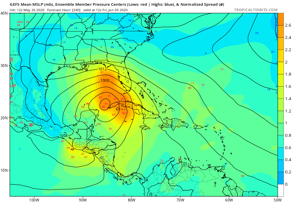
GFS ensembles lighting up. Western tip of Cuba / SE GOM at 240 hours. Strong members in this run:
2 likes
-
AutoPenalti
- Category 5

- Posts: 4091
- Age: 29
- Joined: Mon Aug 17, 2015 4:16 pm
- Location: Ft. Lauderdale, Florida
Re: 2020 Global Model Runs Discussion (Out thru day 16)
gatorcane wrote:GFS ensembles lighting up. Western tip of Cuba / SE GOM at 240 hours. Strong members in this run:
https://i.postimg.cc/50K6g90K/gfs-ememb-lowlocs-watl-41.png
This being 10 days out and knowing that the GFS can throw out fantasy forecasts past 240, I would say "eh" and shrug, but the fact that it's been consistently growing, kinda concerns me.
1 likes
The posts in this forum are NOT official forecasts and should not be used as such. They are just the opinion of the poster and may or may not be backed by sound meteorological data. They are NOT endorsed by any professional institution or STORM2K. For official information, please refer to products from the NHC and NWS.
Model Runs Cheat Sheet:
GFS (5:30 AM/PM, 11:30 AM/PM)
HWRF, GFDL, UKMET, NAVGEM (6:30-8:00 AM/PM, 12:30-2:00 AM/PM)
ECMWF (1:45 AM/PM)
TCVN is a weighted averaged
-
toad strangler

- S2K Supporter
- Posts: 4546
- Joined: Sun Jul 28, 2013 3:09 pm
- Location: Earth
- Contact:
Re: 2020 Global Model Runs Discussion (Out thru day 16)
The entire gigantic CAG snaps off and spirals into TX on the 18Z Happy Hour GFS 
1 likes
My Weather Station
https://www.wunderground.com/dashboard/pws/KFLPORTS603
https://www.wunderground.com/dashboard/pws/KFLPORTS603
Who is online
Users browsing this forum: No registered users and 99 guests