interestingly.. the 12z ICON almost develops something in the NW carrib.. lol
something to keep an eye on for sure now..
ATL: CRISTOBAL - Models
Moderator: S2k Moderators
-
Aric Dunn
- Category 5

- Posts: 21238
- Age: 43
- Joined: Sun Sep 19, 2004 9:58 pm
- Location: Ready for the Chase.
- Contact:
Re: ATL: CRISTOBAL - Models
0 likes
Note: If I make a post that is brief. Please refer back to previous posts for the analysis or reasoning. I do not re-write/qoute what my initial post said each time.
If there is nothing before... then just ask
Space & Atmospheric Physicist, Embry-Riddle Aeronautical University,
I believe the sky is falling...
If there is nothing before... then just ask
Space & Atmospheric Physicist, Embry-Riddle Aeronautical University,
I believe the sky is falling...

Re: ATL: CRISTOBAL - Models
Aric Dunn wrote:interestingly.. the 12z ICON almost develops something in the NW carrib.. lol
something to keep an eye on for sure now..
I recall the GFS showing this about 4 or so days ago. At that time it looked like back to back systems but maybe it was catching on to something? Time will tell.
1 likes
-
TheProfessor

- Professional-Met

- Posts: 3506
- Age: 29
- Joined: Tue Dec 03, 2013 10:56 am
- Location: Wichita, Kansas
Re: ATL: CRISTOBAL - Models
12z GFS showing a westward bend as well, an interesting trend in the 12z models.
0 likes
An alumnus of The Ohio State University.
Your local National Weather Service office is your best source for weather information.
Your local National Weather Service office is your best source for weather information.
-
gatorcane

- S2K Supporter

- Posts: 23708
- Age: 48
- Joined: Sun Mar 13, 2005 3:54 pm
- Location: Boca Raton, FL
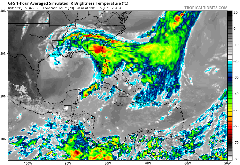
Re: ATL: CRISTOBAL - Models
Doesn’t even look tropical when it landfalls in LA as shown by 12Z GFS simulation. All the rainfall and any winds are hundreds of miles east of landfall over Florida:
1 likes
-
MississippiWx

- S2K Supporter
- Posts: 1720
- Joined: Sat Aug 14, 2010 1:44 pm
- Location: Hattiesburg, Mississippi
Re: ATL: CRISTOBAL - Models
gatorcane wrote:Doesn’t even look tropical when it landfalls in LA as shown by 12Z GFS simulation. All the rainfall and any winds are hundreds of miles east of landfall over Florida:
https://i.postimg.cc/dQxNBKcN/gfs-ir-watl-14.png
I think the Northern Gulf Coast leads the world in being dry slotted on the east side of tropical cyclones. It happens every year. We desperately need the rain in South Ms, La, AL, and in the Panhandle of FL. I’m not so sure that Cristobal is going to be what we need it to be.
0 likes
This post is not an official forecast and should not be used as such. It is just the opinion of MississippiWx and may or may not be backed by sound meteorological data. It is not endorsed by any professional institution including storm2k.org. For Official Information please refer to the NHC and NWS products.
-
Aric Dunn
- Category 5
- Posts: 21238
- Age: 43
- Joined: Sun Sep 19, 2004 9:58 pm
- Location: Ready for the Chase.
- Contact:
Re: ATL: CRISTOBAL - Models
Really GFS.. bringing Christobal back over the gulf after a loop over the southern US... lol
1 likes
Note: If I make a post that is brief. Please refer back to previous posts for the analysis or reasoning. I do not re-write/qoute what my initial post said each time.
If there is nothing before... then just ask
Space & Atmospheric Physicist, Embry-Riddle Aeronautical University,
I believe the sky is falling...
If there is nothing before... then just ask
Space & Atmospheric Physicist, Embry-Riddle Aeronautical University,
I believe the sky is falling...

Re: ATL: CRISTOBAL - Models
Aric Dunn wrote:Really GFS.. bringing Christobal back over the gulf after a loop over the southern US... lol
No, we’re not having this gyre system die and regenerate enough times to get Edouard by mid-June. Not happening.
3 likes
Irene '11 Sandy '12 Hermine '16 5/15/2018 Derecho Fay '20 Isaias '20 Elsa '21 Henri '21 Ida '21
I am only a meteorology enthusiast who knows a decent amount about tropical cyclones. Look to the professional mets, the NHC, or your local weather office for the best information.
I am only a meteorology enthusiast who knows a decent amount about tropical cyclones. Look to the professional mets, the NHC, or your local weather office for the best information.
-
Stormcenter
- S2K Supporter
- Posts: 6689
- Joined: Wed Sep 03, 2003 11:27 am
- Location: Houston, TX

Re: ATL: CRISTOBAL - Models
Here's the 12 QPF. 2.5-5" of rain across the immediate Gulf Coast from the Keys up to the LA/TX border. Not extreme, but you know there will likely be some higher totals.
https://www.wpc.ncep.noaa.gov/qpf/p168i.gif?1591289013
Here's the current MJO. According to the CPC, MJO should reach Phase 2 sometime tomorrow. Phase 2 is a very strong signal for the NC Gulf, probably the strongest one of all for something to come toward LA/MS or possibly Texas. Most of the models don't show deep amplification except possibly the JMA. So a couple days in 2 and then we'll see where it goes from there.
https://www.cpc.ncep.noaa.gov/products/ ... r_wh.shtml
2 likes
-
Aric Dunn
- Category 5
- Posts: 21238
- Age: 43
- Joined: Sun Sep 19, 2004 9:58 pm
- Location: Ready for the Chase.
- Contact:
Re: ATL: CRISTOBAL - Models
so far this GFS run.. we see Dolly, Fay, and possibly Edouard and the next after that lol ..
0 likes
Note: If I make a post that is brief. Please refer back to previous posts for the analysis or reasoning. I do not re-write/qoute what my initial post said each time.
If there is nothing before... then just ask
Space & Atmospheric Physicist, Embry-Riddle Aeronautical University,
I believe the sky is falling...
If there is nothing before... then just ask
Space & Atmospheric Physicist, Embry-Riddle Aeronautical University,
I believe the sky is falling...
Re: ATL: CRISTOBAL - Models
CMC slides east and makes landfall around Lake Pontchartrain Northshore (Slidell +/-) with the severe rains of a foot+ around Panama City, Tallahassee and points east.
HWRF goes in around Vermilion Bay @ 998mb Sunday afternoon.
HMON goes in a little farther east around Cocodrie at 998mb Sunday evening.
HWRF-P goes in Vermilion Bay at 995mb Sunday evening.
Waiting on the Euro and the GFS/EC Ensembles a bit later. Euro is out to 24 hours and has Chrisobal near the tip of the Yucatan tomorrow morning.
0 likes
-
PTrackerLA

- Category 5
- Posts: 5281
- Age: 42
- Joined: Thu Oct 10, 2002 8:40 pm
- Location: Lafayette, LA
Re: ATL: CRISTOBAL - Models
Steve wrote:CMC slides east and makes landfall around Lake Pontchartrain Northshore (Slidell +/-) with the severe rains of a foot+ around Panama City, Tallahassee and points east.
HWRF goes in around Vermilion Bay @ 998mb Sunday afternoon.
HMON goes in a little farther east around Cocodrie at 998mb Sunday evening.
HWRF-P goes in Vermilion Bay at 995mb Sunday evening.
Waiting on the Euro and the GFS/EC Ensembles a bit later. Euro is out to 24 hours and has Chrisobal near the tip of the Yucatan tomorrow morning.
12z Euro comes offshore a bit west of the 00z out to 24 and 48 hours
0 likes
Re: ATL: CRISTOBAL - Models
EC out to 48 hours and looks stronger than any other model at that point (994mb). 22.1 / 92.1. Since it's the EC, you have to give it a little weight regardless of whether it's right or not.
0 likes
-
tolakram
- Admin

- Posts: 20179
- Age: 62
- Joined: Sun Aug 27, 2006 8:23 pm
- Location: Florence, KY (name is Mark)
Re: ATL: CRISTOBAL - Models
Let's hope it doesn't get trapped or this will be yet another nasty flooding event.

2 likes
M a r k
- - - - -
Join us in chat: Storm2K Chatroom Invite. Android and IOS apps also available.
The posts in this forum are NOT official forecasts and should not be used as such. Posts are NOT endorsed by any professional institution or STORM2K.org. For official information and forecasts, please refer to NHC and NWS products.

Re: ATL: CRISTOBAL - Models
Big west shift on the 12z Euro. Pretty close to the LA/TX border.
2 likes

Re: ATL: CRISTOBAL - Models
Flooding to the east of the center (all the way to the FL panhandle) is gonna be the biggest problem with this storm imo
0 likes
Re: ATL: CRISTOBAL - Models
Cpv17 wrote:Big west shift on the 12z Euro. Pretty close to the LA/TX border.
It shows Landfall at 990mb (strong tropical storm or slightly possible low-end Cat 1) Monday am near Vermilion Bay. So it's about 12 hours slower than the Hurricane Models but landfalls near where the HWRF and HWRF-P have it.
0 likes
Re: ATL: CRISTOBAL - Models
Steve wrote:Cpv17 wrote:Big west shift on the 12z Euro. Pretty close to the LA/TX border.
It shows Landfall at 990mb (strong tropical storm or slightly possible low-end Cat 1) Monday am near Vermilion Bay. So it's about 12 hours slower than the Hurricane Models but landfalls near where the HWRF and HWRF-P have it.
I’ve heard rumblings about the slower it moves, the more west it’ll go.
1 likes
Re: ATL: CRISTOBAL - Models
GEFS ensembles focus around the LA/TX border.
GEPS ensembles focus around Grand Isle.
GEPS ensembles focus around Grand Isle.
0 likes

Re: ATL: CRISTOBAL - Models
Just like on its previous 06z run, the Euro is forecasting a stronger ridge to its north.

3 likes
Who is online
Users browsing this forum: No registered users and 105 guests