2020 Indicators: SST's / SAL / MSLP / Steering / Shear / Instability / Sat Images

This is the general tropical discussion area. Anyone can take their shot at predicting a storms path.

Moderator: S2k Moderators

Forum rules

The posts in this forum are NOT official forecasts and should not be used as such. They are just the opinion of the poster and may or may not be backed by sound meteorological data. They are NOT endorsed by any professional institution or STORM2K. For official information, please refer to products from the National Hurricane Center and National Weather Service.

Help Support Storm2K
Message
Author
TheStormExpert

Re: 2020 Indicators: SST's / SAL / MSLP / Steering / Shear / Instability / Sat Images

#761 Postby TheStormExpert » Tue Jun 09, 2020 8:50 am

SFLcane wrote:Just keeps getting better! :eek: Euro predicting a stronger then normal Bermuda high for Aug,Sept,Oct

https://twitter.com/webberweather/status/1270336893717286912

As if 2020 just keeps getting better! :roll:
0 likes   

AutoPenalti
Category 5
Category 5
Posts: 4030
Age: 29
Joined: Mon Aug 17, 2015 4:16 pm
Location: Ft. Lauderdale, Florida

Re: 2020 Indicators: SST's / SAL / MSLP / Steering / Shear / Instability / Sat Images

#762 Postby AutoPenalti » Tue Jun 09, 2020 8:57 am

SFLcane wrote:Just keeps getting better! :eek: Euro predicting a stronger then normal Bermuda high for Aug,Sept,Oct

https://twitter.com/webberweather/status/1270336893717286912

Don't know how much I believe this considering it's bias towards stronger ridging. We will see though.
0 likes   
The posts in this forum are NOT official forecasts and should not be used as such. They are just the opinion of the poster and may or may not be backed by sound meteorological data. They are NOT endorsed by any professional institution or STORM2K. For official information, please refer to products from the NHC and NWS.


Model Runs Cheat Sheet:
GFS (5:30 AM/PM, 11:30 AM/PM)
HWRF, GFDL, UKMET, NAVGEM (6:30-8:00 AM/PM, 12:30-2:00 AM/PM)
ECMWF (1:45 AM/PM)

TCVN
is a weighted averaged

User avatar
cycloneye
Admin
Admin
Posts: 145300
Age: 68
Joined: Thu Oct 10, 2002 10:54 am
Location: San Juan, Puerto Rico

Re: 2020 Indicators: SST's / SAL / MSLP / Steering / Shear / Instability / Sat Images

#763 Postby cycloneye » Tue Jun 09, 2020 9:21 am

SFLcane wrote:Just keeps getting better! :eek: Euro predicting a stronger then normal Bermuda high for Aug,Sept,Oct

https://twitter.com/webberweather/status/1270336893717286912


In plain words, Caribbean cruisers may be a norm in 2020. :eek:
0 likes   
Visit the Caribbean-Central America Weather Thread where you can find at first post web cams,radars
and observations from Caribbean basin members Click Here

User avatar
weathaguyry
Category 5
Category 5
Posts: 1272
Age: 22
Joined: Wed Jun 15, 2016 5:16 am
Location: Long Island, NY

Re: 2020 Indicators: SST's / SAL / MSLP / Steering / Shear / Instability / Sat Images

#764 Postby weathaguyry » Tue Jun 09, 2020 10:02 am

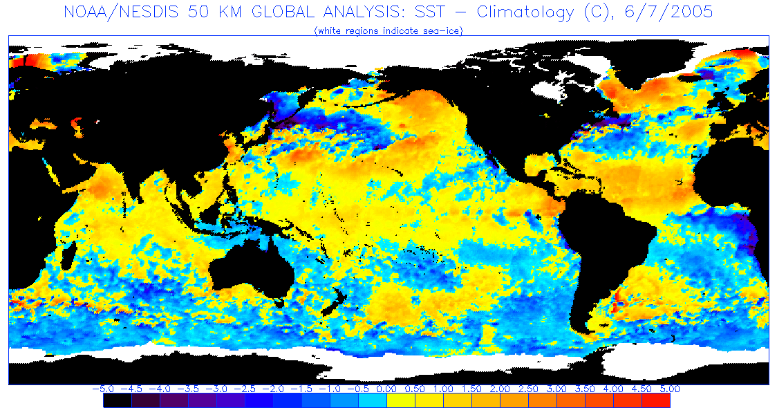
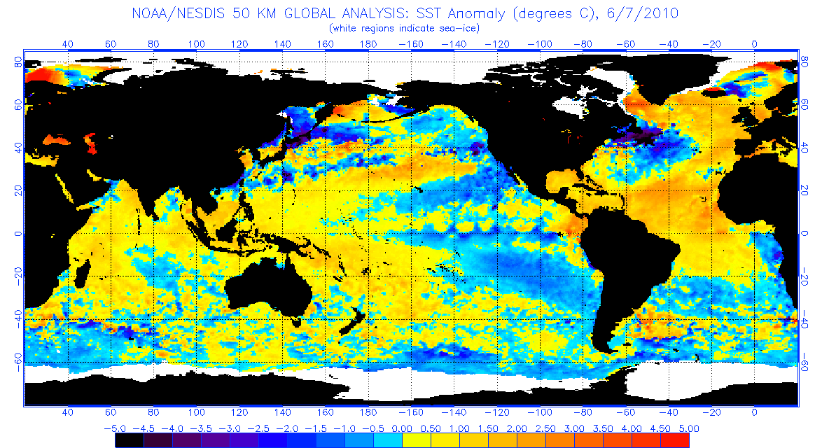
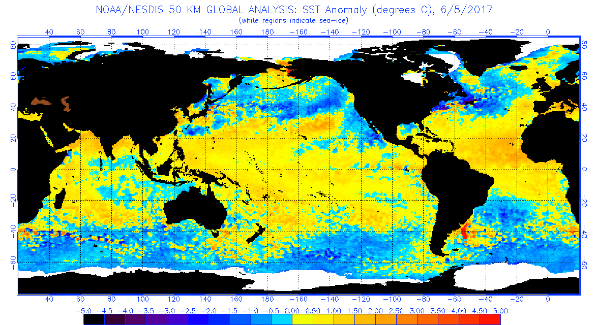
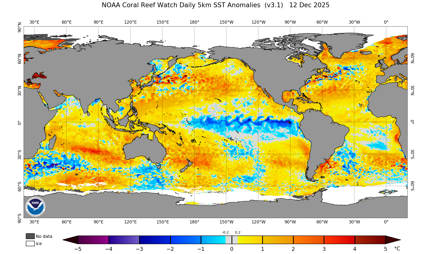
This very positive AMO setting up has me extremely concerned, the current SST profile is starting to look increasingly similar to hyperactive years like 2005, 2010, and 2017...

Current 2020 Anomalies
Image

2005 Anomalies
Image

2010 Anomalies
Image

2017 Anomalies
Image
8 likes   
My posts are only my opinions and NOT official forecasts. For official forecasts, consult the National Hurricane Center or the National Weather Service.

Irene 11', Sandy 12', Fay 20’, Isaias 20’, Elsa 21’, Henri 21’, Ida 21’

Shell Mound
Category 5
Category 5
Posts: 2434
Age: 32
Joined: Thu Sep 07, 2017 3:39 pm
Location: St. Petersburg, FL → Scandinavia

Re: 2020 Indicators: SST's / SAL / MSLP / Steering / Shear / Instability / Sat Images

#765 Postby Shell Mound » Tue Jun 09, 2020 11:52 am

AutoPenalti wrote:
SFLcane wrote:Just keeps getting better! :eek: Euro predicting a stronger then normal Bermuda high for Aug,Sept,Oct

https://twitter.com/webberweather/status/1270336893717286912
Don't know how much I believe this considering it's bias towards stronger ridging. We will see though.

 https://twitter.com/catinsight/status/1270342562872786944


 https://twitter.com/catinsight/status/1270339970360901632


 https://twitter.com/WorldClimateSvc/status/1270344884298416128


 https://twitter.com/catinsight/status/1270360565974806529


0 likes   
CVW / MiamiensisWx / Shell Mound
The posts in this forum are NOT official forecasts and should not be used as such. They are just the opinion of the poster and may or may not be backed by sound meteorological data. They are NOT endorsed by any professional institution or STORM2K. For official information, please refer to products from the NHC and NWS.

Shell Mound
Category 5
Category 5
Posts: 2434
Age: 32
Joined: Thu Sep 07, 2017 3:39 pm
Location: St. Petersburg, FL → Scandinavia

Re: 2020 Indicators: SST's / SAL / MSLP / Steering / Shear / Instability / Sat Images

#766 Postby Shell Mound » Tue Jun 09, 2020 11:55 am

2 likes   
CVW / MiamiensisWx / Shell Mound
The posts in this forum are NOT official forecasts and should not be used as such. They are just the opinion of the poster and may or may not be backed by sound meteorological data. They are NOT endorsed by any professional institution or STORM2K. For official information, please refer to products from the NHC and NWS.

AutoPenalti
Category 5
Category 5
Posts: 4030
Age: 29
Joined: Mon Aug 17, 2015 4:16 pm
Location: Ft. Lauderdale, Florida

Re: 2020 Indicators: SST's / SAL / MSLP / Steering / Shear / Instability / Sat Images

#767 Postby AutoPenalti » Tue Jun 09, 2020 12:28 pm

Yikes, the healthy Hadley cell gives me Irma vibes.
5 likes   
The posts in this forum are NOT official forecasts and should not be used as such. They are just the opinion of the poster and may or may not be backed by sound meteorological data. They are NOT endorsed by any professional institution or STORM2K. For official information, please refer to products from the NHC and NWS.


Model Runs Cheat Sheet:
GFS (5:30 AM/PM, 11:30 AM/PM)
HWRF, GFDL, UKMET, NAVGEM (6:30-8:00 AM/PM, 12:30-2:00 AM/PM)
ECMWF (1:45 AM/PM)

TCVN
is a weighted averaged

User avatar
NDG
S2K Supporter
S2K Supporter
Posts: 15446
Joined: Sun Jul 09, 2006 10:14 pm
Location: Orlando, FL

Re: 2020 Indicators: SST's / SAL / MSLP / Steering / Shear / Instability / Sat Images

#768 Postby NDG » Tue Jun 09, 2020 2:02 pm

Saharan dust has not made much progress to the west this season so far, I remember that by this time last year it was already raging across the Caribbean.
1 likes   

User avatar
JetFuel_SE
Category 1
Category 1
Posts: 282
Age: 25
Joined: Thu Apr 30, 2020 3:57 pm

Re: 2020 Indicators: SST's / SAL / MSLP / Steering / Shear / Instability / Sat Images

#769 Postby JetFuel_SE » Tue Jun 09, 2020 2:46 pm

NDG wrote:Saharan dust has not made much progress to the west this season so far, I remember that by this time last year it was already raging across the Caribbean.


And this means what for the hurricane season?
0 likes   

User avatar
NDG
S2K Supporter
S2K Supporter
Posts: 15446
Joined: Sun Jul 09, 2006 10:14 pm
Location: Orlando, FL

Re: 2020 Indicators: SST's / SAL / MSLP / Steering / Shear / Instability / Sat Images

#770 Postby NDG » Tue Jun 09, 2020 3:25 pm

JetFuel_SE wrote:
NDG wrote:Saharan dust has not made much progress to the west this season so far, I remember that by this time last year it was already raging across the Caribbean.


And this means what for the hurricane season?


Saharan dust all the way into the western Caribbean and GOM usually means strong trades & subsidence across the Atlantic MDR and puts a lid on development for a while.
0 likes   

User avatar
JetFuel_SE
Category 1
Category 1
Posts: 282
Age: 25
Joined: Thu Apr 30, 2020 3:57 pm

Re: 2020 Indicators: SST's / SAL / MSLP / Steering / Shear / Instability / Sat Images

#771 Postby JetFuel_SE » Tue Jun 09, 2020 3:30 pm

NDG wrote:
JetFuel_SE wrote:
NDG wrote:Saharan dust has not made much progress to the west this season so far, I remember that by this time last year it was already raging across the Caribbean.


And this means what for the hurricane season?


Saharan dust all the way into the western Caribbean and GOM usually means strong trades & subsidence across the Atlantic MDR and puts a lid on development for a while.


I may have worded that poorly, I meant something more like does this mean it's delayed or will we have very little SAL this year?
0 likes   

USTropics
Professional-Met
Professional-Met
Posts: 2650
Joined: Sun Aug 12, 2007 3:45 am
Location: Florida State University

Re: 2020 Indicators: SST's / SAL / MSLP / Steering / Shear / Instability / Sat Images

#772 Postby USTropics » Tue Jun 09, 2020 4:07 pm

JetFuel_SE wrote:
NDG wrote:
JetFuel_SE wrote:
And this means what for the hurricane season?


Saharan dust all the way into the western Caribbean and GOM usually means strong trades & subsidence across the Atlantic MDR and puts a lid on development for a while.


I may have worded that poorly, I meant something more like does this mean it's delayed or will we have very little SAL this year?


We'll have SAL outbreaks this year, especially as the ITCZ continues to lift north and increases the pressure gradient (common for peak SAL to be mid July - early August). The question remains, to what effect though? There is a correlation between an active/nonactive African Sahel monsoon season and an decrease/increase in SAL outbreaks. This is due to an active/nonactive monsoon pattern increasing/decreasing relative humidity, decreasing/increasing vertical wind shear, and thus decreasing/increasing dust load. We have had an active Sahel monsoon season so far:

Image


This is a pretty cool 10 day forecast of SAL produced by NASA using GEOS-5 processing:

[youtube]https://youtu.be/cRNTU3JbpRw[/youtube]

Src - https://svs.gsfc.nasa.gov/4582

As far as ITCZ location this year, there has been a subtle movement towards the north in the past 10 days. The eastern branch is near normal location, however the western branch still remains slightly south to date:

Image

Image
9 likes   

WeatherEmperor
S2K Supporter
S2K Supporter
Posts: 4806
Age: 41
Joined: Thu Sep 04, 2003 2:54 pm
Location: South Florida

Re: 2020 Indicators: SST's / SAL / MSLP / Steering / Shear / Instability / Sat Images

#773 Postby WeatherEmperor » Tue Jun 09, 2020 7:30 pm

One thing I want to make sure I understand. In terms of steering, are we looking at more of a 1996/1998/1999 steering or more like a 2004/2017 steering pattern? The reason I ask is because in 1996/1998/1999, we had multiple cape verde hurricanes turn north into the Carolinas whereas in 2004/2017 there was stronger high pressure sending hurricanes into Florida. Which of these 2 patterns is more likely this season?


Sent from my iPhone using Tapatalk
1 likes   

User avatar
cycloneye
Admin
Admin
Posts: 145300
Age: 68
Joined: Thu Oct 10, 2002 10:54 am
Location: San Juan, Puerto Rico

Re: 2020 Indicators: SST's / SAL / MSLP / Steering / Shear / Instability / Sat Images

#774 Postby cycloneye » Tue Jun 09, 2020 8:16 pm

3 likes   
Visit the Caribbean-Central America Weather Thread where you can find at first post web cams,radars
and observations from Caribbean basin members Click Here

User avatar
FireRat
Category 5
Category 5
Posts: 1246
Age: 38
Joined: Sun Sep 26, 2010 11:38 pm
Location: North Carolina

Re: 2020 Indicators: SST's / SAL / MSLP / Steering / Shear / Instability / Sat Images

#775 Postby FireRat » Tue Jun 09, 2020 9:00 pm

WeatherEmperor wrote:One thing I want to make sure I understand. In terms of steering, are we looking at more of a 1996/1998/1999 steering or more like a 2004/2017 steering pattern? The reason I ask is because in 1996/1998/1999, we had multiple cape verde hurricanes turn north into the Carolinas whereas in 2004/2017 there was stronger high pressure sending hurricanes into Florida. Which of these 2 patterns is more likely this season?


Sent from my iPhone using Tapatalk


Hi WeatherEmperor, if things pan out the way they look right now, especially with a STRONGER than normal Bermuda High, chances are that we will see more of a 2004/2017 steering pattern. A stronger Bermuda High would be less likely to weaken and allow hurricanes to go poleward ahead of the troughs. Instead, the high could remain firmly in control and send the storms more west, like into the Islands, Caribbean, FL and even the GOM. However the Carolinas would still be in play, because even with a strong Bermuda High, if it is far offshore, the storms could follow the edge of the High into SC/NC kind of like Hugo from 1989.

It really is tough to say what kind of steering we will have this far out, of course, but with the current indicators I'd go with a 2017 type steering pattern. This simply means that it would be unlikely to have most of the storms going out to sea, and instead hurtle toward land. Ultimately, for a Carolinas impact, or a FL/Carib impact, it will depend on both the strength and position of the Bermuda High, as well as the strength of any troughs by then.
2 likes   
Georges '98, Irene '99, Frances '04, Jeanne '04, Katrina '05, Wilma '05, Gustav '08, Isaac '12, Matthew '16, Florence '18, Michael '18, Ian '22

Shell Mound
Category 5
Category 5
Posts: 2434
Age: 32
Joined: Thu Sep 07, 2017 3:39 pm
Location: St. Petersburg, FL → Scandinavia

Re: 2020 Indicators: SST's / SAL / MSLP / Steering / Shear / Instability / Sat Images

#776 Postby Shell Mound » Wed Jun 10, 2020 12:25 am


This will probably result in some (short-term, that is) cooling of the MDR due to enhanced low-level divergence (trades) south of the PV axis.
0 likes   
CVW / MiamiensisWx / Shell Mound
The posts in this forum are NOT official forecasts and should not be used as such. They are just the opinion of the poster and may or may not be backed by sound meteorological data. They are NOT endorsed by any professional institution or STORM2K. For official information, please refer to products from the NHC and NWS.

User avatar
NDG
S2K Supporter
S2K Supporter
Posts: 15446
Joined: Sun Jul 09, 2006 10:14 pm
Location: Orlando, FL

Re: 2020 Indicators: SST's / SAL / MSLP / Steering / Shear / Instability / Sat Images

#777 Postby NDG » Wed Jun 10, 2020 6:21 am

USTropics wrote:
JetFuel_SE wrote:
NDG wrote:
Saharan dust all the way into the western Caribbean and GOM usually means strong trades & subsidence across the Atlantic MDR and puts a lid on development for a while.


I may have worded that poorly, I meant something more like does this mean it's delayed or will we have very little SAL this year?


We'll have SAL outbreaks this year, especially as the ITCZ continues to lift north and increases the pressure gradient (common for peak SAL to be mid July - early August). The question remains, to what effect though? There is a correlation between an active/nonactive African Sahel monsoon season and an decrease/increase in SAL outbreaks. This is due to an active/nonactive monsoon pattern increasing/decreasing relative humidity, decreasing/increasing vertical wind shear, and thus decreasing/increasing dust load. We have had an active Sahel monsoon season so far:

https://i.imgur.com/umrhCRH.png


This is a pretty cool 10 day forecast of SAL produced by NASA using GEOS-5 processing:

https://youtu.be/cRNTU3JbpRw

Src - https://svs.gsfc.nasa.gov/4582

As far as ITCZ location this year, there has been a subtle movement towards the north in the past 10 days. The eastern branch is near normal location, however the western branch still remains slightly south to date:

https://i.imgur.com/EnUiYMI.jpg

https://i.imgur.com/jsD7vQ2.gif


Not only is the Saharan dessert a dust producing machine, China is one heck of a pollution maker :eek:
0 likes   

User avatar
cycloneye
Admin
Admin
Posts: 145300
Age: 68
Joined: Thu Oct 10, 2002 10:54 am
Location: San Juan, Puerto Rico

Re: 2020 Indicators: SST's / SAL / MSLP / Steering / Shear / Instability / Sat Images

#778 Postby cycloneye » Wed Jun 10, 2020 8:49 am

0 likes   
Visit the Caribbean-Central America Weather Thread where you can find at first post web cams,radars
and observations from Caribbean basin members Click Here

User avatar
cycloneye
Admin
Admin
Posts: 145300
Age: 68
Joined: Thu Oct 10, 2002 10:54 am
Location: San Juan, Puerto Rico

Re: 2020 Indicators: SST's / SAL / MSLP / Steering / Shear / Instability / Sat Images

#779 Postby cycloneye » Wed Jun 10, 2020 9:38 am

0 likes   
Visit the Caribbean-Central America Weather Thread where you can find at first post web cams,radars
and observations from Caribbean basin members Click Here

User avatar
cycloneye
Admin
Admin
Posts: 145300
Age: 68
Joined: Thu Oct 10, 2002 10:54 am
Location: San Juan, Puerto Rico

Re: 2020 Indicators: SST's / SAL / MSLP / Steering / Shear / Instability / Sat Images

#780 Postby cycloneye » Wed Jun 10, 2020 10:20 am

0 likes   
Visit the Caribbean-Central America Weather Thread where you can find at first post web cams,radars
and observations from Caribbean basin members Click Here


Return to “Talkin' Tropics”

Who is online

Users browsing this forum: Ulf and 25 guests