Discussion of Intense Tropical Cyclones
Moderator: S2k Moderators
Forum rules

The posts in this forum are NOT official forecasts and should not be used as such. They are just the opinion of the poster and may or may not be backed by sound meteorological data. They are NOT endorsed by any professional institution or STORM2K. For official information, please refer to products from the National Hurricane Center and National Weather Service.
-
CrazyC83
- Professional-Met

- Posts: 34316
- Joined: Tue Mar 07, 2006 11:57 pm
- Location: Deep South, for the first time!
Re: Discussion of Intense Tropical Cyclones
I think 1995 and 1996 in particular could use a significant reanalysis. That was the beginning of the "modern era" and current instruments were in their infancy, hence the flight level wind rules were just being established for USAFR flights.
5 likes

Re: Discussion of Intense Tropical Cyclones
I think so too! 1996 likely had Cat 5 Edouard, and Hortense possibly was a little stronger at peak too.
In 1995, Luis might have been a tad stronger at peak as well.
I can imagine the ACE for these seasons, especially 1996, might get bumped up after reanalysis.
95-96 was also the start of the multi-decadal active era, "modern era" indeed!
In 1995, Luis might have been a tad stronger at peak as well.
I can imagine the ACE for these seasons, especially 1996, might get bumped up after reanalysis.
95-96 was also the start of the multi-decadal active era, "modern era" indeed!
0 likes
Georges '98, Irene '99, Frances '04, Jeanne '04, Katrina '05, Wilma '05, Gustav '08, Isaac '12, Matthew '16, Florence '18, Michael '18, Ian '22

Re: Discussion of Intense Tropical Cyclones
Is there an archive of Dvorak imagery for Atlantic and EPac storms from 1980-2010? I’m curious to see what some of the high-end Cat 4s of them 90s (Luis, Floyd, Lenny, etc) looked like via Dvorak and if any of them could’ve been low-end Cat 5s.
1 likes
Irene '11 Sandy '12 Hermine '16 5/15/2018 Derecho Fay '20 Isaias '20 Elsa '21 Henri '21 Ida '21
I am only a meteorology enthusiast who knows a decent amount about tropical cyclones. Look to the professional mets, the NHC, or your local weather office for the best information.
I am only a meteorology enthusiast who knows a decent amount about tropical cyclones. Look to the professional mets, the NHC, or your local weather office for the best information.
-
J_J99
- Tropical Depression

- Posts: 68
- Age: 26
- Joined: Wed Mar 09, 2016 9:43 pm
- Location: Cincinnati, OH
Re: Discussion of Intense Tropical Cyclones
Im curious about Opal.... it had a 916 mb pressure, incredibly low for just a Category 4 hurricane. They also measured 152 kts at the 700 mb FL right after they measured 916 mb. Opal was an odd hurricane with very widespread winds but a very small eye and area of maximum winds. I think it is possible Opal could have briefly attained category 5 status.
0 likes
The following post is NOT an official forecast and should not be used as such. It is just the opinion of the poster and may or may not be backed by sound meteorological data. It is NOT endorsed by any professional institution including storm2k.org For Official Information please refer to the NHC and NWS products.
Re: Discussion of Intense Tropical Cyclones
J_J99 wrote:Im curious about Opal.... it had a 916 mb pressure, incredibly low for just a Category 4 hurricane. They also measured 152 kts at the 700 mb FL right after they measured 916 mb. Opal was an odd hurricane with very widespread winds but a very small eye and area of maximum winds. I think it is possible Opal could have briefly attained category 5 status.
I think Michael's highest flight level winds were 152kts as well if I remember correctly, and with a very similar pressure, 919mb. Also same time of year and in the gulf, heading in a northerly direction. Taking into account these similarities, I think it would be very reasonable for a reanalysis of Opal to bump peak intensity up to 140kts.
0 likes
Solar Aquarian
Lunar Cancerian
 Sagittarian
Lunar Cancerian
-
BYG Jacob
Re: Discussion of Intense Tropical Cyclones
The monstrosity of 2007, thankfully he made landfall in sparsely populated territory.
2 likes
Re: Discussion of Intense Tropical Cyclones
Mean Dean was quite a beast indeed!! 
That year was the first one in the 2000s that actually had a Cat 5 Landfall at peak intensity I believe.
That year was the first one in the 2000s that actually had a Cat 5 Landfall at peak intensity I believe.
0 likes
Georges '98, Irene '99, Frances '04, Jeanne '04, Katrina '05, Wilma '05, Gustav '08, Isaac '12, Matthew '16, Florence '18, Michael '18, Ian '22
Re: Discussion of Intense Tropical Cyclones
Didn’t Felix ‘07 have some absurdly high SFMR readings like Dorian? I think I recall some people bringing that up when Dorian was peaking.
2 likes
Irene '11 Sandy '12 Hermine '16 5/15/2018 Derecho Fay '20 Isaias '20 Elsa '21 Henri '21 Ida '21
I am only a meteorology enthusiast who knows a decent amount about tropical cyclones. Look to the professional mets, the NHC, or your local weather office for the best information.
I am only a meteorology enthusiast who knows a decent amount about tropical cyclones. Look to the professional mets, the NHC, or your local weather office for the best information.
-
HurricaneEnzo

- Category 2

- Posts: 744
- Joined: Wed Mar 14, 2018 12:18 pm
- Location: Newport, NC (Hurricane Alley)
Re: RE: Re: Discussion of Intense Tropical Cyclones
Yeah supposedly the readings in Felix were contaminated by graupel so they weren't taken into account. They were around 165kts if I'm not mistaken.aspen wrote:Didn’t Felix ‘07 have some absurdly high SFMR readings like Dorian? I think I recall some people bringing that up when Dorian was peaking.
Sent from my SM-N975U using Tapatalk
2 likes
Bertha 96' - Fran 96' - Bonnie 98' - Dennis 99' - Floyd 99' - Isabel 03' - Alex 04' - Ophelia 05' - Irene 11' - Arthur 14' - Matthew 16' - Florence 18' - Dorian 19' - Isaias 20' (countless other tropical storms and Hurricane swipes)
I am not a Professional Met just an enthusiast. Get your weather forecasts from the Pros!
I am not a Professional Met just an enthusiast. Get your weather forecasts from the Pros!
-
BYG Jacob
Re: RE: Re: Discussion of Intense Tropical Cyclones
HurricaneEnzo wrote:Yeah supposedly the readings in Felix were contaminated by graupel so they weren't taken into account. They were around 165kts if I'm not mistaken.aspen wrote:Didn’t Felix ‘07 have some absurdly high SFMR readings like Dorian? I think I recall some people bringing that up when Dorian was peaking.
Sent from my SM-N975U using Tapatalk
They had to abort that whole flight because of graupel
2 likes
-
Shell Mound
- Category 5

- Posts: 2432
- Age: 33
- Joined: Thu Sep 07, 2017 3:39 pm
- Location: St. Petersburg, FL → Scandinavia
Re: Discussion of Intense Tropical Cyclones
Some of the possible Cat-5s from the EPAC (images courtesy of ibTRACS):
Norma 1981 (official peak in HURDAT2: 110 kt; my estimate: 150-155 kt)
Daniel 1982 (official peak in HURDAT2: 100 kt; my estimate: 145-150 kt)

John 1982 (official peak in HURDAT2: 100 kt; my estimate: 145-150 kt)
Olivia 1982 (official peak in HURDAT2: 125 kt; my estimate: 145-150 kt)
Henriette 1983 (official peak in HURDAT2: 115 kt; my estimate: 145-150 kt)
Kiko 1983 (official peak in HURDAT2: 125 kt; my estimate: 150-155 kt)
Raymond 1983 (official peak in HURDAT2: 125 kt; my estimate: 145-150 kt)
Tico 1983 (official peak in HURDAT2: 125 kt; my estimate: 145-150 kt)
Tico in particular reminds me of Kenna (2002), Norma of Linda (1997), Olivia of Rick (2009).
Norma 1981 (official peak in HURDAT2: 110 kt; my estimate: 150-155 kt)
Daniel 1982 (official peak in HURDAT2: 100 kt; my estimate: 145-150 kt)
John 1982 (official peak in HURDAT2: 100 kt; my estimate: 145-150 kt)
Olivia 1982 (official peak in HURDAT2: 125 kt; my estimate: 145-150 kt)
Henriette 1983 (official peak in HURDAT2: 115 kt; my estimate: 145-150 kt)
Kiko 1983 (official peak in HURDAT2: 125 kt; my estimate: 150-155 kt)
Raymond 1983 (official peak in HURDAT2: 125 kt; my estimate: 145-150 kt)
Tico 1983 (official peak in HURDAT2: 125 kt; my estimate: 145-150 kt)
Tico in particular reminds me of Kenna (2002), Norma of Linda (1997), Olivia of Rick (2009).
5 likes
CVW / MiamiensisWx / Shell Mound
The posts in this forum are NOT official forecasts and should not be used as such. They are just the opinion of the poster and may or may not be backed by sound meteorological data. They are NOT endorsed by any professional institution or STORM2K. For official information, please refer to products from the NHC and NWS.
Re: Discussion of Intense Tropical Cyclones
1 likes
Irene '11 Sandy '12 Hermine '16 5/15/2018 Derecho Fay '20 Isaias '20 Elsa '21 Henri '21 Ida '21
I am only a meteorology enthusiast who knows a decent amount about tropical cyclones. Look to the professional mets, the NHC, or your local weather office for the best information.
I am only a meteorology enthusiast who knows a decent amount about tropical cyclones. Look to the professional mets, the NHC, or your local weather office for the best information.
Re: Discussion of Intense Tropical Cyclones
Wow those 1980s EPAC hurricanes were def underestimated. Norma, Olivia, Kiko, Raymond and Tico take the cake IMO. Easy Cat 5's, probably between 140kt and 150kt.
0 likes
Georges '98, Irene '99, Frances '04, Jeanne '04, Katrina '05, Wilma '05, Gustav '08, Isaac '12, Matthew '16, Florence '18, Michael '18, Ian '22
-
1900hurricane

- Category 5
- Posts: 6063
- Age: 34
- Joined: Fri Feb 06, 2015 12:04 pm
- Location: Houston, TX
- Contact:
Re: Discussion of Intense Tropical Cyclones
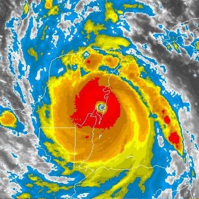
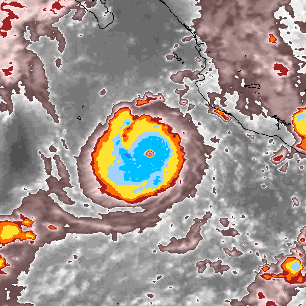
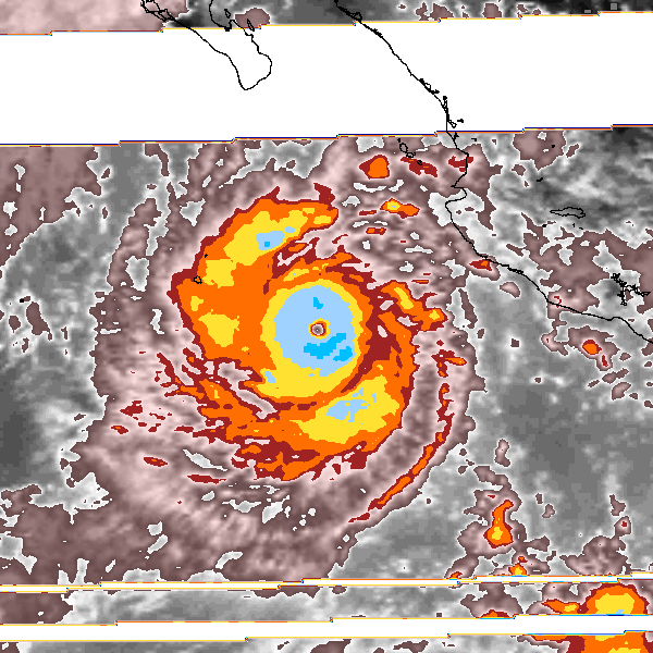
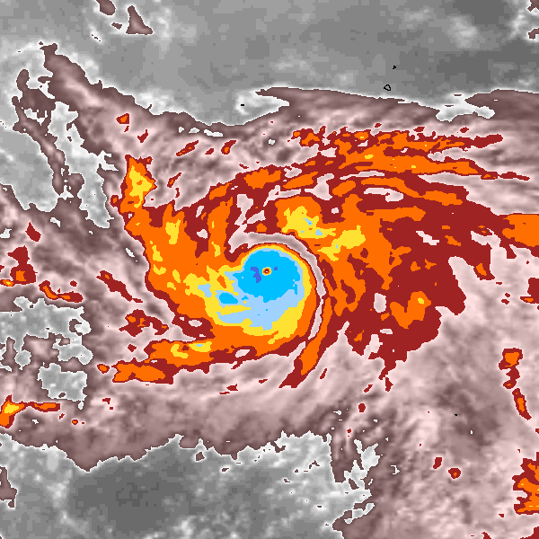
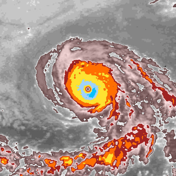
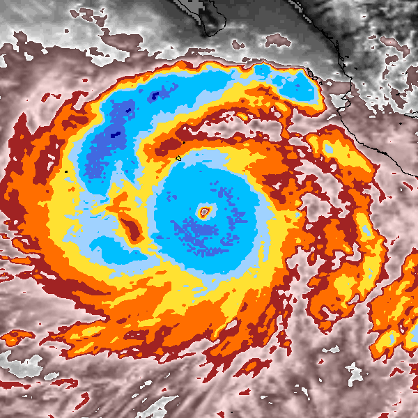
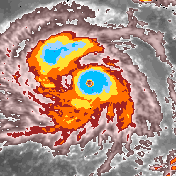
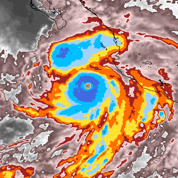
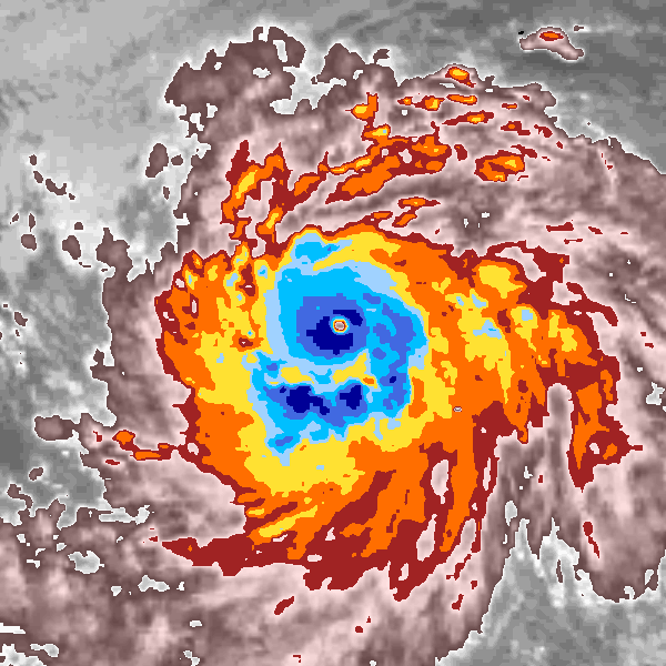
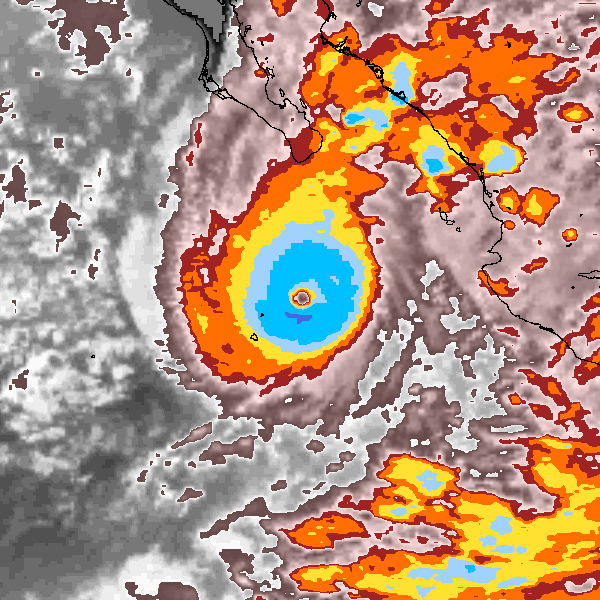
Since it goes beyond the beginning of NRL, I generated a few microwave images of Luis '95, Opal '95, and Edouard '96 as close to peak intensity as I could get.


10 likes
Contract Meteorologist. TAMU & MSST. Fiercely authentic, one of a kind. We are all given free will, so choose a life meant to be lived. We are the Masters of our own Stories.
Opinions expressed are mine alone.
Follow me on Twitter at @1900hurricane : Read blogs at https://1900hurricane.wordpress.com/
Opinions expressed are mine alone.
Follow me on Twitter at @1900hurricane : Read blogs at https://1900hurricane.wordpress.com/
Re: Discussion of Intense Tropical Cyclones
Wow, Luis was such a beast! Such a large and well developed eye, kind of reminds me of Floyd '99 or even Irma.
Edouard was smaller, but definitely had quite an intense core. Mid size hurricane that packed quite a punch!
Opal is the smallest.of the three, and her core was so tiny, wow, can't even discern an eye in that imagery, just red pixels! Pin hole eye y'all.
Cool images 1900hurricane, thanks!
Edouard was smaller, but definitely had quite an intense core. Mid size hurricane that packed quite a punch!
Opal is the smallest.of the three, and her core was so tiny, wow, can't even discern an eye in that imagery, just red pixels! Pin hole eye y'all.
Cool images 1900hurricane, thanks!
1 likes
Georges '98, Irene '99, Frances '04, Jeanne '04, Katrina '05, Wilma '05, Gustav '08, Isaac '12, Matthew '16, Florence '18, Michael '18, Ian '22
-
mrbagyo

- Category 5
- Posts: 3998
- Age: 33
- Joined: Thu Apr 12, 2012 9:18 am
- Location: 14.13N 120.98E
- Contact:
Re: Discussion of Intense Tropical Cyclones
It appears the Japanese conducted sea-based weather recon during the WW2 and one of their weather ship S.S. "No. 4 Kaiyo Maru" recorded some incredible surface observation during an intense typhoon in 1944.
Min pressure - 898 hPa
MSW (5 minute ave) - 65m/s (that's 234 kph!)
Eye temp at the surface : 28.4°C (0.8 to 0.9°C higher than the eyewa temp)
Full Article

Min pressure - 898 hPa
MSW (5 minute ave) - 65m/s (that's 234 kph!)
Eye temp at the surface : 28.4°C (0.8 to 0.9°C higher than the eyewa temp)
Full Article
6 likes
The posts in this forum are NOT official forecast and should not be used as such. They are just the opinion of the poster and may or may not be backed by sound meteorological data. They are NOT endorsed by any professional institution or storm2k.org. For official information, please refer to RSMC, NHC and NWS products.
Re: Discussion of Intense Tropical Cyclones
mrbagyo wrote:It appears the Japanese conducted sea-based weather recon during the WW2 and one of their weather ship S.S. "No. 4 Kaiyo Maru" recorded some incredible surface observation during an intense typhoon in 1944.
Min pressure - 898 hPa
MSW (5 minute ave) - 65m/s (that's 234 kph!)
Eye temp at the surface : 28.4°C (0.8 to 0.9°C higher than the eyewa temp)
Full Article
https://i.imgur.com/EsDvaJD.png
125 kt 5-min sustained winds...what would that translate to in 1-min sustained? It’s certainly a Category 5 just based off of the pressure alone.
0 likes
Irene '11 Sandy '12 Hermine '16 5/15/2018 Derecho Fay '20 Isaias '20 Elsa '21 Henri '21 Ida '21
I am only a meteorology enthusiast who knows a decent amount about tropical cyclones. Look to the professional mets, the NHC, or your local weather office for the best information.
I am only a meteorology enthusiast who knows a decent amount about tropical cyclones. Look to the professional mets, the NHC, or your local weather office for the best information.
Re: Discussion of Intense Tropical Cyclones
Typhoons are definitely the kings of the tropics, 898, gosh! Amazing the ship even survived that one!
As for landfallers, I remember reading once that the typhoon of Nov 1987, Nina I believe, struck the Philippines as a maxed-out Cat 5 and a pressure of 891 mb was measured at landfall. Always was curious about that one and if that reading was indeed real.
Edit: I found some info on this, and yeah it looks like it may have been that low according to the link below:
https://enacademic.com/dic.nsf/enwiki/1874548
0 likes
Georges '98, Irene '99, Frances '04, Jeanne '04, Katrina '05, Wilma '05, Gustav '08, Isaac '12, Matthew '16, Florence '18, Michael '18, Ian '22
Re: Discussion of Intense Tropical Cyclones
FireRat wrote:Typhoons are definitely the kings of the tropics, 898, gosh! Amazing the ship even survived that one!
As for landfallers, I remember reading once that the typhoon of Nov 1987, Nina I believe, struck the Philippines as a maxed-out Cat 5 and a pressure of 891 mb was measured at landfall. Always was curious about that one and if that reading was indeed real.
Edit: I found some info on this, and yeah it looks like it may have been that low according to the link below:
https://enacademic.com/dic.nsf/enwiki/1874548
The 891mb pressure was derived from the Atkinson-Holiday wind-pressure relationship and the 145KT JTWC best track intensity. Lowest pressure recorded in the Philippines at landfall should be 909.5mb for Nina.
2 likes
Personal Forecast Disclaimer:
The posts in this forum are NOT official forecast and should not be used as such. They are just the opinion of the poster and may or may not be backed by sound meteorological data. They are NOT endorsed by any professional institution or storm2k.org. For official information, please refer to RSMC and NWS products.
The posts in this forum are NOT official forecast and should not be used as such. They are just the opinion of the poster and may or may not be backed by sound meteorological data. They are NOT endorsed by any professional institution or storm2k.org. For official information, please refer to RSMC and NWS products.
Who is online
Users browsing this forum: No registered users and 262 guests