EPAC: FOUR-E - Remnants
Moderator: S2k Moderators
-
Kingarabian

- S2K Supporter

- Posts: 16342
- Joined: Sat Aug 08, 2009 3:06 am
- Location: Honolulu, Hawaii
-
Kingarabian
- S2K Supporter
- Posts: 16342
- Joined: Sat Aug 08, 2009 3:06 am
- Location: Honolulu, Hawaii
Re: EPAC: INVEST 95E
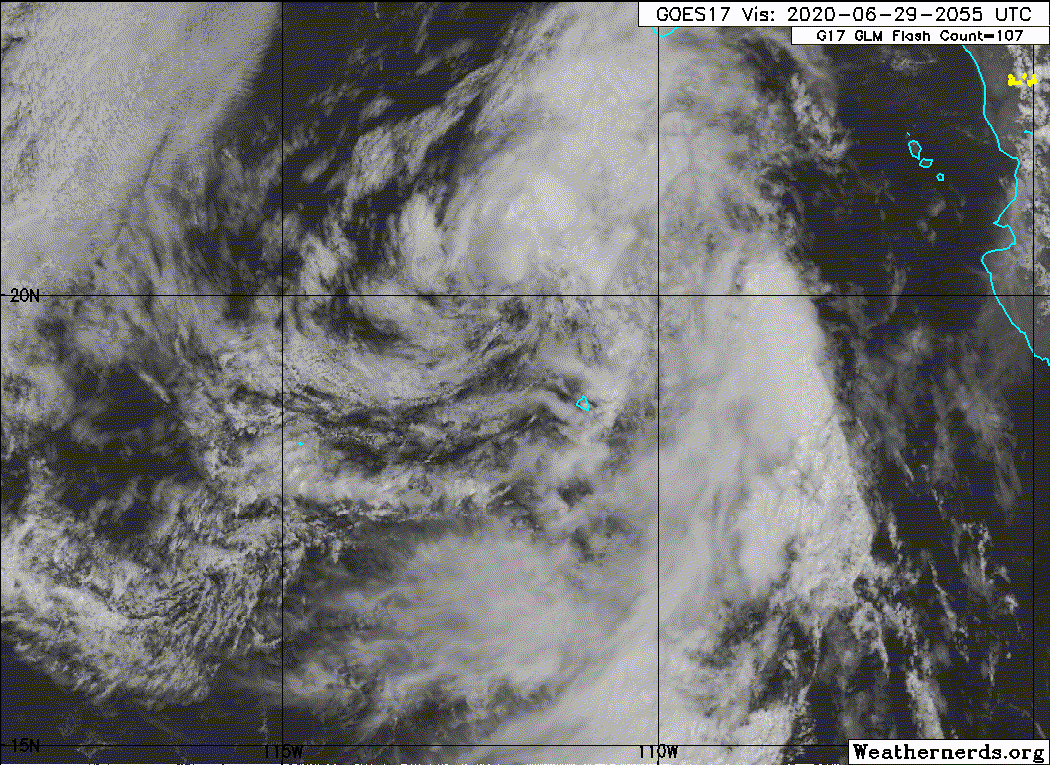
Don't even need ASCAT confirmation lol. It's nicely sheared to show the LLC.

0 likes
RIP Kobe Bryant
-
cycloneye

- Admin

- Posts: 149214
- Age: 69
- Joined: Thu Oct 10, 2002 10:54 am
- Location: San Juan, Puerto Rico
Re: EPAC: INVEST 95E
No upgrade at 2 PM PDT.
0 likes
Visit the Caribbean-Central America Weather Thread where you can find at first post web cams,radars
and observations from Caribbean basin members Click Here
and observations from Caribbean basin members Click Here

Re: EPAC: INVEST 95E
I don’t care what the NHC says (or, in this case, doesn’t say), I’m counting this towards 2020’s totals.
1 likes
Irene '11 Sandy '12 Hermine '16 5/15/2018 Derecho Fay '20 Isaias '20 Elsa '21 Henri '21 Ida '21
I am only a meteorology enthusiast who knows a decent amount about tropical cyclones. Look to the professional mets, the NHC, or your local weather office for the best information.
I am only a meteorology enthusiast who knows a decent amount about tropical cyclones. Look to the professional mets, the NHC, or your local weather office for the best information.
-
Yellow Evan

- Professional-Met

- Posts: 16222
- Age: 27
- Joined: Fri Jul 15, 2011 12:48 pm
- Location: Henderson, Nevada/Honolulu, HI
- Contact:

-
Monsoonjr99
- Tropical Storm

- Posts: 210
- Age: 26
- Joined: Fri Sep 21, 2018 11:22 pm
- Location: Inland Empire, SoCal
Re: EPAC: INVEST 95E
Looks better than Barry.
0 likes
The posts in this forum are NOT official forecasts and should not be used as such. They are just the opinion of the poster and may or may not be backed by sound meteorological data. They are NOT endorsed by any professional institution or STORM2K. For official information, please refer to products from the NHC and NWS.
Some Californian who codes things and tracks weather.
Kay '22, Hilary '23
-
cycloneye
- Admin
- Posts: 149214
- Age: 69
- Joined: Thu Oct 10, 2002 10:54 am
- Location: San Juan, Puerto Rico
Re: EPAC: INVEST 95E
Showers and thunderstorms associated with an area of low pressure
located a couple of hundred miles southwest of the southern tip of
the Baja California peninsula have become slightly less organized
since late this morning. This system, however, could still become
a short-lived tropical depression later today or tonight before it
moves over cooler waters and into an area of less favorable
upper-level winds on Tuesday.
* Formation chance through 48 hours...medium...60 percent.
* Formation chance through 5 days...medium...60 percent.
0 likes
Visit the Caribbean-Central America Weather Thread where you can find at first post web cams,radars
and observations from Caribbean basin members Click Here
and observations from Caribbean basin members Click Here
-
Sciencerocks
- Category 5

- Posts: 10181
- Age: 40
- Joined: Thu Jul 06, 2017 1:51 am
-
Yellow Evan
- Professional-Met
- Posts: 16222
- Age: 27
- Joined: Fri Jul 15, 2011 12:48 pm
- Location: Henderson, Nevada/Honolulu, HI
- Contact:
-
Nancy Smar

- Category 5
- Posts: 1081
- Age: 25
- Joined: Wed Aug 16, 2017 10:03 pm
Re: EPAC: INVEST 95E
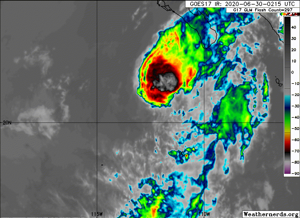
...SPECIAL FEATURES...
Tropical Depression Four-E is centered near 20.5N 112.6W at
30/0300 UTC moving NW at 6 kt. Estimated minimum central
pressure is 1004 mb. Maximum sustained wind speed is 30 kt with
gusts to 40 kt. Numerous moderate and isolated strong convection
is noted within 120 nm in the NE quadrant of the low with
additional scattered moderate and isolated strong convection
elsewhere from 12N to 21N between 107W and 114W. A large area of
seas to 9 ft in S-SW swell surrounds the low center. The
depression is forecast to maintain through Tue, then will become
a remnant low by Tue night, dissipating by early Thu. Please
read the latest NHC Public Advisory at:
https://www.nhc.noaa.gov/text/MIATCPEP4.shtml and Forecast/
Advisory at https://www.nhc.noaa.gov/text/MIATCMEP4.shtml for
more details.
0 likes
-
cycloneye
- Admin
- Posts: 149214
- Age: 69
- Joined: Thu Oct 10, 2002 10:54 am
- Location: San Juan, Puerto Rico
Re: EPAC: Four-E - Tropical Depression
Tropical Depression Four-E Discussion Number 1
NWS National Hurricane Center Miami FL EP042020
900 PM MDT Mon Jun 29 2020
The circulation associated with the area of low pressure located
southwest of the southern tip of the Baja California peninsula has
become better defined over the past 24 hours, and the system has
maintained convection for much of the past 12 hours. Although the
convection has not been particularly well organized at times today,
a new burst of convection developed just northeast of the low-level
center late this afternoon and has been persistent over the past
several hours. Based on these observations and Dvorak T-number of
1.5 from TAFB and 2.0 from SAB, the system is being designated as a
30-kt tropical depression. The system is expected to be a short-
lived tropical cyclone as it will be moving into an area of
increasing southwesterly vertical wind shear and over SSTs of around
24 degrees Celsius by Tuesday morning. As a result, the depression
is forecast to degenerate into a remnant low on Tuesday. The NHC
wind speed prediction follows the trend of the intensity guidance
and also calls for the remnant low to dissipate in 2 to 3 days.
The depression is moving slowly northwestward around the western
portion of a mid-level ridge that extends westward over central
Mexico. The cyclone should continue moving on the same general
heading with some reduction in forward speed as it weakens and is
steered by the weaker low-level flow. The NHC track forecast is
near the middle of the guidance envelope in best agreement
with the HFIP corrected consensus model.
FORECAST POSITIONS AND MAX WINDS
INIT 30/0300Z 20.5N 112.6W 30 KT 35 MPH
12H 30/1200Z 21.1N 113.2W 30 KT 35 MPH
24H 01/0000Z 21.4N 113.5W 25 KT 30 MPH...POST-TROP/REMNT LOW
36H 01/1200Z 21.6N 113.7W 20 KT 25 MPH...POST-TROP/REMNT LOW
48H 02/0000Z 21.8N 113.8W 15 KT 15 MPH...POST-TROP/REMNT LOW
60H 02/1200Z...DISSIPATED
$$
Forecaster Brown
0 likes
Visit the Caribbean-Central America Weather Thread where you can find at first post web cams,radars
and observations from Caribbean basin members Click Here
and observations from Caribbean basin members Click Here
-
Yellow Evan
- Professional-Met
- Posts: 16222
- Age: 27
- Joined: Fri Jul 15, 2011 12:48 pm
- Location: Henderson, Nevada/Honolulu, HI
- Contact:
Re: EPAC: FOUR-E - Tropical Depression
Worth pointing out that genesis at this latitude is quite unusual in any month other than September. Could be a sign for the rest of the season.
Last edited by Yellow Evan on Mon Jun 29, 2020 11:10 pm, edited 1 time in total.
0 likes
-
Yellow Evan
- Professional-Met
- Posts: 16222
- Age: 27
- Joined: Fri Jul 15, 2011 12:48 pm
- Location: Henderson, Nevada/Honolulu, HI
- Contact:
Re: EPAC: FOUR-E - Tropical Depression

Classic somewhat sheared but also fueled by poleward outflow look.
0 likes
-
TheStormExpert

Re: EPAC: FOUR-E - Tropical Depression
Hey, at least it’s something. Might be the last EPac system we get for a few weeks.
0 likes
Irene '11 Sandy '12 Hermine '16 5/15/2018 Derecho Fay '20 Isaias '20 Elsa '21 Henri '21 Ida '21
I am only a meteorology enthusiast who knows a decent amount about tropical cyclones. Look to the professional mets, the NHC, or your local weather office for the best information.
I am only a meteorology enthusiast who knows a decent amount about tropical cyclones. Look to the professional mets, the NHC, or your local weather office for the best information.
-
Astromanía
- Category 2

- Posts: 793
- Age: 27
- Joined: Sat Aug 25, 2018 10:34 pm
- Location: Monterrey, N.L, México
Re: EPAC: FOUR-E - Tropical Depression
TheStormExpert wrote:Should be gone in less than 24hrs.
Ahhh but if this was an Atlantic system in the middle of the ocean as well then this would have already 20 pages in this forum
4 likes
-
Sciencerocks
- Category 5
- Posts: 10181
- Age: 40
- Joined: Thu Jul 06, 2017 1:51 am
-
cycloneye
- Admin
- Posts: 149214
- Age: 69
- Joined: Thu Oct 10, 2002 10:54 am
- Location: San Juan, Puerto Rico
Re: EPAC: FOUR-E - Tropical Depression
Tropical Depression Four-E Discussion Number 2
NWS National Hurricane Center Miami FL EP042020
300 AM MDT Tue Jun 30 2020
Deep convection associated with the depression has waned since last
night and is now limited to a small burst displaced more than
75 n mi northeast of the cyclone's low-level center. An ASCAT-B pass
at 0517 UTC showed max winds of only 20-25 kt, so the intensity has
been lowered to 25 kt. The cyclone is now located over 24 deg C
waters and substantial redevelopment or organization of convection
is unlikely. It is therefore forecast to become a remnant low later
today. The remnant low should then spin down over the course of the
next couple of days until it dissipates later this week.
The depression has continued to move slowly northwestward, steered
by a mid-level ridge to its east. Once the cyclone becomes a remnant
low later today, weak low-level steering flow will likely cause the
system to meander for a few days until it dissipates. The NHC
forecast (both track and intensity) is mostly unchanged from the
previous advisory.
FORECAST POSITIONS AND MAX WINDS
INIT 30/0900Z 20.6N 113.2W 25 KT 30 MPH
12H 30/1800Z 20.9N 113.5W 25 KT 30 MPH...POST-TROP/REMNT LOW
24H 01/0600Z 21.0N 113.6W 20 KT 25 MPH...POST-TROP/REMNT LOW
36H 01/1800Z 21.2N 113.7W 20 KT 25 MPH...POST-TROP/REMNT LOW
48H 02/0600Z 21.6N 114.0W 15 KT 15 MPH...POST-TROP/REMNT LOW
60H 02/1800Z...DISSIPATED
$$
Forecaster Zelinsky
0 likes
Visit the Caribbean-Central America Weather Thread where you can find at first post web cams,radars
and observations from Caribbean basin members Click Here
and observations from Caribbean basin members Click Here
-
wxman57

- Moderator-Pro Met

- Posts: 23170
- Age: 68
- Joined: Sat Jun 21, 2003 8:06 pm
- Location: Houston, TX (southwest)
Re: EPAC: FOUR-E - Tropical Depression
Convection has dissipated. It was likely a TS on Sunday when ScatSat had a couple 35kt winds. Started weakening early Monday and was nearly a remnant low when it was finally classified as a TD.

4 likes
-
Yellow Evan
- Professional-Met
- Posts: 16222
- Age: 27
- Joined: Fri Jul 15, 2011 12:48 pm
- Location: Henderson, Nevada/Honolulu, HI
- Contact:
Re: EPAC: FOUR-E - Tropical Depression
2 likes
Who is online
Users browsing this forum: No registered users and 22 guests