000
ABNT20 KNHC 040357
TWOAT
Special Tropical Weather Outlook
NWS National Hurricane Center Miami FL
1200 AM EDT Sat Jul 4 2020
For the North Atlantic...Caribbean Sea and the Gulf of Mexico:
Special Tropical Weather Outlook issued to discuss potential
tropical development of low pressure system southwest of Bermuda.
An area of thunderstorms has persisted near the center of a small
low pressure system located more than 300 miles southwest of
Bermuda. Recent satellite-derived surface wind data indicate that
winds have increased and that the circulation has become better
defined. If this recent development trend continues, then a tropical
depression could form overnight or early Saturday while the system
moves eastward at about 15 mph. By Sunday night, however,
environmental conditions are expected to become unfavorable for
significant development to occur. Interests in Bermuda should
monitor the progress of this system.
* Formation chance through 48 hours...medium...40 percent.
* Formation chance through 5 days...medium...40 percent.
$$
Forecaster Blake/Stewart
ATL: EDOUARD - Post-Tropical - Discussion
Moderator: S2k Moderators
-
Nancy Smar

- Category 5

- Posts: 1081
- Age: 25
- Joined: Wed Aug 16, 2017 10:03 pm
Re: ATL: INVEST 97L - Discussion
1 likes
-
Aric Dunn
- Category 5
- Posts: 21238
- Age: 43
- Joined: Sun Sep 19, 2004 9:58 pm
- Location: Ready for the Chase.
- Contact:
Re: ATL: INVEST 97L - Discussion
Nancy Smar wrote:000
ABNT20 KNHC 040357
TWOAT
Special Tropical Weather Outlook
NWS National Hurricane Center Miami FL
1200 AM EDT Sat Jul 4 2020
For the North Atlantic...Caribbean Sea and the Gulf of Mexico:
Special Tropical Weather Outlook issued to discuss potential
tropical development of low pressure system southwest of Bermuda.
An area of thunderstorms has persisted near the center of a small
low pressure system located more than 300 miles southwest of
Bermuda. Recent satellite-derived surface wind data indicate that
winds have increased and that the circulation has become better
defined. If this recent development trend continues, then a tropical
depression could form overnight or early Saturday while the system
moves eastward at about 15 mph. By Sunday night, however,
environmental conditions are expected to become unfavorable for
significant development to occur. Interests in Bermuda should
monitor the progress of this system.
* Formation chance through 48 hours...medium...40 percent.
* Formation chance through 5 days...medium...40 percent.
$$
Forecaster Blake/Stewart
a little surprised they did a STWO .. only two hours until 2 am..
they do like to go up incrementally... 2am might go up to 60 percent or more.
only debate really is if its a TS..
a TD is pretty much a given.
Last edited by Aric Dunn on Fri Jul 03, 2020 11:08 pm, edited 2 times in total.
0 likes
Note: If I make a post that is brief. Please refer back to previous posts for the analysis or reasoning. I do not re-write/qoute what my initial post said each time.
If there is nothing before... then just ask
Space & Atmospheric Physicist, Embry-Riddle Aeronautical University,
I believe the sky is falling...
If there is nothing before... then just ask
Space & Atmospheric Physicist, Embry-Riddle Aeronautical University,
I believe the sky is falling...

Re: ATL: INVEST 97L - Discussion
The thing to remember with ASCAT is that I believe it's been stated by a couple pros that it can under sample and have a low bias, especially with smaller, tighter circulations. There might be some 35-45kt winds, just not in a very large area, so ASCAT would have trouble resolving it. I think the ATL is going to celebrate the 4th by giving us Edouard.
Off topic real quick, but Happy 4th to all of you as well and I hope you all have a wonderful and safe holiday weekend!
Off topic real quick, but Happy 4th to all of you as well and I hope you all have a wonderful and safe holiday weekend!
4 likes
Solar Aquarian
Lunar Cancerian
 Sagittarian
Lunar Cancerian
-
toad strangler

- S2K Supporter

- Posts: 4546
- Joined: Sun Jul 28, 2013 3:09 pm
- Location: Earth
- Contact:
-
NXStumpy_Robothing
- Category 1

- Posts: 335
- Age: 25
- Joined: Fri Jun 05, 2020 11:50 pm
- Location: North Georgia
Re: ATL: INVEST 97L - Discussion
Unfortunately for 97L, shear has taken its toll on the convection, displacing it to the south and west of the center. There might be another small window between now and tomorrow evening for it to make a run for TS status, but I feel like that scenario is looking increasingly unlikely.
I'm not ruling it out though; I've been proven wrong by doing that before. It seems like we'll just have to wait and see.
I'm not ruling it out though; I've been proven wrong by doing that before. It seems like we'll just have to wait and see.
0 likes
Undergraduate Meteorology Student, Georgia Institute of Technology
-
Sciencerocks
- Category 5
- Posts: 10181
- Age: 40
- Joined: Thu Jul 06, 2017 1:51 am
-
JetFuel_SE

- Category 1
- Posts: 286
- Age: 26
- Joined: Thu Apr 30, 2020 3:57 pm
-
cycloneye

- Admin

- Posts: 149275
- Age: 69
- Joined: Thu Oct 10, 2002 10:54 am
- Location: San Juan, Puerto Rico
Re: ATL: INVEST 97L - Discussion
Tropical Weather Outlook
NWS National Hurricane Center Miami FL
800 AM EDT Sat Jul 4 2020
For the North Atlantic...Caribbean Sea and the Gulf of Mexico:
A small area of low pressure located about 300 miles west-southwest
of Bermuda continues to produce persistent showers and
thunderstorms. The system appears to be getting better organized,
and if current trends continue, it could become a tropical
depression later today or tonight while it moves east-northeastward
or northeastward at about 15 mph. Environmental conditions are
expected to become unfavorable for further development by late
Sunday. Interests in Bermuda should monitor the progress of this
system.
* Formation chance through 48 hours...medium...60 percent.
* Formation chance through 5 days...medium...60 percent.
$$
Forecaster Zelinsky
0 likes
Visit the Caribbean-Central America Weather Thread where you can find at first post web cams,radars
and observations from Caribbean basin members Click Here
and observations from Caribbean basin members Click Here
-
northjaxpro

- S2K Supporter
- Posts: 8900
- Joined: Mon Sep 27, 2010 11:21 am
- Location: Jacksonville, FL
Re: ATL: INVEST 97L - Discussion
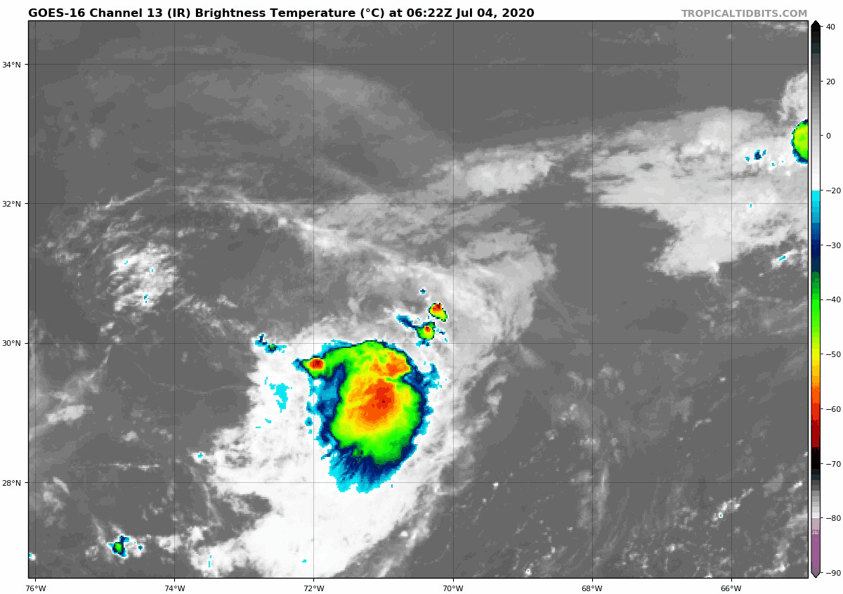
Ouch... 97L ģot stretched overnight , after having a very nice looking compact LLC with deep convection.
Small cyclones like these can ramp up quickly, but they can also decline quickly as well because its small size makes their enviŕonment much more susceptible to feel adverse conditions when it presents itself. This is why they are so extremely challenging to analyze. Convection is pulsating again this morning near the LLC, so it will be interesting to see if 97L can recover. But time is its enemy now as hostile shear is awaiting it in about the next 24 -36 hours.
I think there may be just enough of window of time to possibly see Edouard from this. We will see.
Last edited by northjaxpro on Sat Jul 04, 2020 7:22 am, edited 1 time in total.
0 likes
NEVER, EVER SAY NEVER in the tropics and weather in general, and most importantly, with life itself!!
________________________________________________________________________________________
Fay 2008 Beryl 2012 Debby 2012 Colin 2016 Hermine 2016 Julia 2016 Matthew 2016 Irma 2017 Dorian 2019
________________________________________________________________________________________
Fay 2008 Beryl 2012 Debby 2012 Colin 2016 Hermine 2016 Julia 2016 Matthew 2016 Irma 2017 Dorian 2019
-
plasticup
Re: ATL: INVEST 97L - Discussion
First visible looks good. I don’t suppose there is any chance of some recon - can be really useful with these tiny systems.
1 likes
-
ScottNAtlanta

- Category 5
- Posts: 2535
- Joined: Sat May 25, 2013 3:11 pm
- Location: Atlanta, GA
Re: ATL: INVEST 97L - Discussion
Looks like a big blow up right near the center this morning. It still could get there.
0 likes
The posts in this forum are NOT official forecast and should not be used as such. They are just the opinion of the poster and may or may not be backed by sound meteorological data. They are NOT endorsed by any professional institution or storm2k.org. For official information, please refer to the NHC and NWS products.
-
CyclonicFury

- Category 5
- Posts: 2032
- Age: 27
- Joined: Sun Jul 02, 2017 12:32 pm
- Location: NC
- Contact:
Re: ATL: INVEST 97L - Discussion
Station 41048
NDBC
Location: 31.831N 69.573W
Date: Sat, 4 Jul 2020 13:30:00 UTC
Winds: E (80°) at 5.8 kt gusting to 9.7 kt
Atmospheric Pressure: 29.86 in
NDBC
Location: 31.831N 69.573W
Date: Sat, 4 Jul 2020 13:30:00 UTC
Winds: E (80°) at 5.8 kt gusting to 9.7 kt
Atmospheric Pressure: 29.86 in
0 likes
NCSU B.S. in Meteorology Class of 2021. Tropical weather blogger at http://www.cyclonicfury.com. My forecasts and thoughts are NOT official, for official forecasts please consult the National Hurricane Center.

Re: ATL: INVEST 97L - Discussion
Starting to come into view on the Bermuda radar, which recently got expanded to 500km.
http://www.weather.bm/tools/graphics.asp?name=500KM%20PPI&user=
http://www.weather.bm/tools/graphics.asp?name=500KM%20PPI&user=
1 likes
Igor 2010, Sandy 2012, Fay 2014, Gonzalo 2014, Joaquin 2015, Nicole 2016, Humberto 2019, Imelda 2025
I am only a tropical weather enthusiast. My predictions are not official and may or may not be backed by sound meteorological data. For official information, please refer to the NHC and NWS products.
I am only a tropical weather enthusiast. My predictions are not official and may or may not be backed by sound meteorological data. For official information, please refer to the NHC and NWS products.
-
cycloneye
- Admin
- Posts: 149275
- Age: 69
- Joined: Thu Oct 10, 2002 10:54 am
- Location: San Juan, Puerto Rico
Re: ATL: FIVE - Tropical Depression - Discussion
3 likes
Visit the Caribbean-Central America Weather Thread where you can find at first post web cams,radars
and observations from Caribbean basin members Click Here
and observations from Caribbean basin members Click Here
-
Nancy Smar
- Category 5
- Posts: 1081
- Age: 25
- Joined: Wed Aug 16, 2017 10:03 pm
Re: ATL: FIVE - Tropical Depression - Discussion
cycloneye wrote:https://twitter.com/NHC_Atlantic/status/1279416573774532610
AL, 05, 2020070412, , BEST, 0, 309N, 694W, 30, 1009, TD, 34, NEQ, 0, 0, 0, 0, 1012, 120, 30, 40, 0, L, 0, , 0, 0, FIVE, M, 0, , 0, 0, 0, 0, genesis-num, 016, TRANSITIONED, alA72020 to al052020,
0 likes

Re: ATL: FIVE - Tropical Depression - Discussion
cycloneye wrote:https://twitter.com/NHC_Atlantic/status/1279416573774532610
If TD5 becomes Edouard today, it will be the earliest 5th named storm on record, beating out Emily ‘05 by exactly a week.
0 likes
Irene '11 Sandy '12 Hermine '16 5/15/2018 Derecho Fay '20 Isaias '20 Elsa '21 Henri '21 Ida '21
I am only a meteorology enthusiast who knows a decent amount about tropical cyclones. Look to the professional mets, the NHC, or your local weather office for the best information.
I am only a meteorology enthusiast who knows a decent amount about tropical cyclones. Look to the professional mets, the NHC, or your local weather office for the best information.
-
TheStormExpert
Re: ATL: FIVE - Tropical Depression - Discussion
Welp, it's only July 4th and we've already had 5 Tropical Cyclones. So much for season cancel. 
4 likes
-
Aric Dunn
- Category 5
- Posts: 21238
- Age: 43
- Joined: Sun Sep 19, 2004 9:58 pm
- Location: Ready for the Chase.
- Contact:
Re: ATL: FIVE - Tropical Depression - Discussion
Should become Edouard today. convection building nicely around the center. still has plenty of time with decent environment.
0 likes
Note: If I make a post that is brief. Please refer back to previous posts for the analysis or reasoning. I do not re-write/qoute what my initial post said each time.
If there is nothing before... then just ask
Space & Atmospheric Physicist, Embry-Riddle Aeronautical University,
I believe the sky is falling...
If there is nothing before... then just ask
Space & Atmospheric Physicist, Embry-Riddle Aeronautical University,
I believe the sky is falling...
-
northjaxpro
- S2K Supporter
- Posts: 8900
- Joined: Mon Sep 27, 2010 11:21 am
- Location: Jacksonville, FL
Re: ATL: FIVE - Tropical Depression - Discussion
Yes. This likely will be designated Edouard this afternoon or early this evening.
The cyclone really re-organizng quite well late this morning!
The cyclone really re-organizng quite well late this morning!
2 likes
NEVER, EVER SAY NEVER in the tropics and weather in general, and most importantly, with life itself!!
________________________________________________________________________________________
Fay 2008 Beryl 2012 Debby 2012 Colin 2016 Hermine 2016 Julia 2016 Matthew 2016 Irma 2017 Dorian 2019
________________________________________________________________________________________
Fay 2008 Beryl 2012 Debby 2012 Colin 2016 Hermine 2016 Julia 2016 Matthew 2016 Irma 2017 Dorian 2019
-
toad strangler
- S2K Supporter
- Posts: 4546
- Joined: Sun Jul 28, 2013 3:09 pm
- Location: Earth
- Contact:
Re: ATL: FIVE - Tropical Depression - Discussion
It looks great!
It looks like crap
It's coming back!
It's all stretched out
It'll be named later today!
Ahhhh almost in mid season form here at S2K
It looks like crap
It's coming back!
It's all stretched out
It'll be named later today!
Ahhhh almost in mid season form here at S2K
10 likes
My Weather Station
https://www.wunderground.com/dashboard/pws/KFLPORTS603
https://www.wunderground.com/dashboard/pws/KFLPORTS603
Who is online
Users browsing this forum: No registered users and 58 guests