137 KB. Source: Data from the Weather and Hazards Data Viewer. Plot made using QGIS.

Moderator: S2k Moderators


GCANE wrote:It took that hard left and then seems to have stalled a bit.
https://i.imgur.com/dooqMb4.png


TheStormExpert wrote:How is Fay still classifiable as purely Tropical in nature? If anything it could easily be Post-Tropical in my opinion on the 5pm advisory. Not to mention The Weather Channel is comparing it to notable Nor’easters!

NXStumpy_Robothing wrote:GCANE wrote:It took that hard left and then seems to have stalled a bit.
https://i.imgur.com/dooqMb4.png
Well, that line appears to be following the eddy inside the LLC that is now consolidating said circulation tighter around it, and, while Fay may have slowed down slightly, the general motion of the system is still NNE.
OT from your comment, but this storm has been absolutely gorgeous visually. I'm appreciating it before it begins to degrade over land later today.
GCANE wrote:It took that hard left and then seems to have stalled a bit.
https://i.imgur.com/dooqMb4.png
Hammy wrote:Track and satellite appearance remind me of Danielle in 1992. Not common we see tropical storms ride up the coast here, especially if they're not long trackers that came from further south.


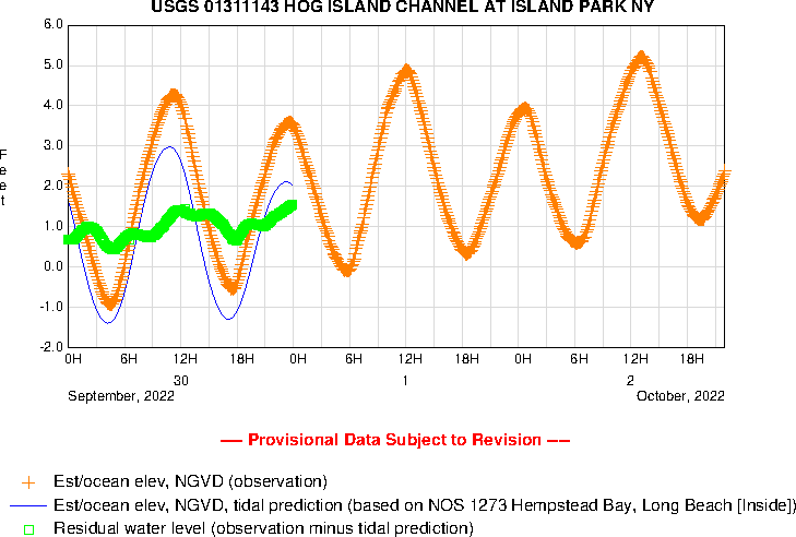
weathaguyry wrote:https://ny.water.usgs.gov/rt/pub/01311143_z_002400.gif
Tide is not going out as much as it should be here on Southern Long Island, this will be an interesting few hours as the center passes directly to my west

plasticup wrote:weathaguyry wrote:https://ny.water.usgs.gov/rt/pub/01311143_z_002400.gif
Tide is not going out as much as it should be here on Southern Long Island, this will be an interesting few hours as the center passes directly to my west
Looks like at most 2 feet of surge. Probably less. Will that be a problem?
Users browsing this forum: No registered users and 74 guests