2020 Indicators: SST's / SAL / MSLP / Steering / Shear / Instability / Sat Images

This is the general tropical discussion area. Anyone can take their shot at predicting a storms path.

Moderator: S2k Moderators

Forum rules

The posts in this forum are NOT official forecasts and should not be used as such. They are just the opinion of the poster and may or may not be backed by sound meteorological data. They are NOT endorsed by any professional institution or STORM2K. For official information, please refer to products from the National Hurricane Center and National Weather Service.

Help Support Storm2K
Message
Author
Chris90
Category 2
Category 2
Posts: 646
Age: 35
Joined: Thu Jun 01, 2017 9:36 pm

Re: 2020 Indicators: SST's / SAL / MSLP / Steering / Shear / Instability / Sat Images

#1581 Postby Chris90 » Mon Jul 13, 2020 12:35 pm

TheStormExpert wrote:
supercane4867 wrote:
TheStormExpert wrote:What about 2013?

Both WHEM basins were uneventful but WPAC was fairly active. Remember Typhoon Haiyan occurred in 2013.

Yeah I remember Haiyan but that was later in the year. I don’t recall anything else of significance.


Haiyan dominated the news cycle and tropical discussion for that year, but the WPAC was decently active overall for the season, with 5 total super typhoons. It crammed a lot of its ACE generation into the Sep-Oct-Nov period with a very clear peak. There were a couple big storms before those months, but a majority occurred towards the end of the season. The first 2/3 of the season are noted as being weak, with the last third being the part of the season that knocked it out of the park. I think the way the WPAC came to life towards the end of 2013 was one of the first big indicators of the active state the Pacific basin was headed towards, that culminated in the super niño of 2015.

Another notable storm that year in the Northern Hemisphere was Phailin over in the Northern Indian ocean basin, specifically the Bay of Bengal.

The lack of activity in the Pacific this year coupled with the way systems have been struggling when they do finally occur is one of the big signs to me offering validation to those indicators that the ATL is going to be active. I don't think we've got long to wait until the basin really gets going with the true tropical development. I think a Top 3 most active season is a definite possibility.
7 likes   
Solar Aquarian
Lunar Cancerian
:uarrow: Sagittarian

TheStormExpert

Re: 2020 Indicators: SST's / SAL / MSLP / Steering / Shear / Instability / Sat Images

#1582 Postby TheStormExpert » Mon Jul 13, 2020 12:36 pm

jaxfladude wrote:What in 2020 a quiet hurricane season in terms of impacts threats etc finally some good news....or another 2020 bad things yet to come?

Sent from my LG-SP320 using Tapatalk

It’s 2020, we’ll likely see something of significance affect land one way or another. :lol:

Hopefully everyone is continuing to prepare for this season more so than others with COVID-19 in mind.
2 likes   

BYG Jacob

Re: 2020 Indicators: SST's / SAL / MSLP / Steering / Shear / Instability / Sat Images

#1583 Postby BYG Jacob » Mon Jul 13, 2020 3:04 pm

Seems this flavor of the month is Florida's risk. Hint for y'all, its really high.

EDIT: Completely unrelated; KOALA BEAR
Last edited by BYG Jacob on Mon Jul 13, 2020 3:19 pm, edited 1 time in total.
0 likes   

MarioProtVI
Category 4
Category 4
Posts: 935
Age: 24
Joined: Sun Sep 29, 2019 7:33 pm
Location: New Jersey

Re: 2020 Indicators: SST's / SAL / MSLP / Steering / Shear / Instability / Sat Images

#1584 Postby MarioProtVI » Mon Jul 13, 2020 3:15 pm

Image

Quite low for July standards especially the Caribbean :double: if this continues till the peak we could be in big trouble, which does align with some of the models.
8 likes   

User avatar
captainbarbossa19
Professional-Met
Professional-Met
Posts: 1092
Age: 27
Joined: Wed Aug 21, 2019 11:09 pm
Location: Beaumont, TX

Re: 2020 Indicators: SST's / SAL / MSLP / Steering / Shear / Instability / Sat Images

#1585 Postby captainbarbossa19 » Mon Jul 13, 2020 3:30 pm

MarioProtVI wrote:http://tropic.ssec.wisc.edu/real-time/atlantic/winds/wg8shr.GIF

Quite low for July standards especially the Caribbean :double: if this continues till the peak we could be in big trouble, which does align with some of the models.


That is very low shear. In previous years at this time, the Caribbean had generally unfavorable conditions. I don't like seeing the favorable conditions in the Gulf too. Today at my location, it is almost 100 degrees. The strong ridge nearby is causing very hot conditions, but I am concerned that it won't be here if a storm enters the Gulf later this year. I have seen some projections of the ridge shifting to the east coast later this summer. I have seen this happen before (2017 with Harvey).
1 likes   

Nuno
Category 2
Category 2
Posts: 597
Joined: Fri Aug 30, 2019 8:35 am
Location: Coral Gables, FL

Re: 2020 Indicators: SST's / SAL / MSLP / Steering / Shear / Instability / Sat Images

#1586 Postby Nuno » Mon Jul 13, 2020 3:31 pm

MarioProtVI wrote:http://tropic.ssec.wisc.edu/real-time/atlantic/winds/wg8shr.GIF

Quite low for July standards especially the Caribbean :double: if this continues till the peak we could be in big trouble, which does align with some of the models.


It's wild how favorable the Caribbean is shaping up to be. I would be shocked if there was no major hurricane down there by September.
1 likes   
Andrew (1992), Irene (1999), Frances (2004), Katrina (2005), Wilma (2005), Fay (2008), Irma (2017), Eta (2020), Ian (2022)

User avatar
NDG
S2K Supporter
S2K Supporter
Posts: 15446
Joined: Sun Jul 09, 2006 10:14 pm
Location: Orlando, FL

Re: 2020 Indicators: SST's / SAL / MSLP / Steering / Shear / Instability / Sat Images

#1587 Postby NDG » Mon Jul 13, 2020 3:36 pm

MarioProtVI wrote:http://tropic.ssec.wisc.edu/real-time/atlantic/winds/wg8shr.GIF

Quite low for July standards especially the Caribbean :double: if this continues till the peak we could be in big trouble, which does align with some of the models.


This is a very big precursor of what the peak of the season will be like when we look at the shear anomaly over the Caribbean during July.
Below average shear= active rest of the season most likely.
Above average shear= not so active rest of the season most likely.
5 likes   

psyclone
S2K Supporter
S2K Supporter
Posts: 4762
Joined: Wed Aug 24, 2005 9:04 pm
Location: palm harbor fl

Re: 2020 Indicators: SST's / SAL / MSLP / Steering / Shear / Instability / Sat Images

#1588 Postby psyclone » Mon Jul 13, 2020 3:44 pm

Meanwhile...ridging which has stubbornly been to the south is poised to build north and yield a more typical southeast wind direction over florida. The pieces are relentlessly falling into place...and we still have a couple weeks before we even begin to climb the climo ramp.
4 likes   

CrazyC83
Professional-Met
Professional-Met
Posts: 34002
Joined: Tue Mar 07, 2006 11:57 pm
Location: Deep South, for the first time!

Re: 2020 Indicators: SST's / SAL / MSLP / Steering / Shear / Instability / Sat Images

#1589 Postby CrazyC83 » Mon Jul 13, 2020 4:04 pm

How does 2020 compare to 2011 at this point in terms of these factors? It seems that those have been comparable in the high number of early weak storms.
0 likes   

TheStormExpert

Re: 2020 Indicators: SST's / SAL / MSLP / Steering / Shear / Instability / Sat Images

#1590 Postby TheStormExpert » Mon Jul 13, 2020 4:35 pm

CrazyC83 wrote:How does 2020 compare to 2011 at this point in terms of these factors? It seems that those have been comparable in the high number of early weak storms.

Conditions seem more favorable than in 2011.
0 likes   

User avatar
SFLcane
S2K Supporter
S2K Supporter
Posts: 10163
Age: 47
Joined: Sat Jun 05, 2010 1:44 pm
Location: Lake Worth Florida

Re: 2020 Indicators: SST's / SAL / MSLP / Steering / Shear / Instability / Sat Images

#1591 Postby SFLcane » Mon Jul 13, 2020 5:04 pm

New EURO weeklies.. :crazyeyes: We should start seeing actual tc's in the modeling in time. Very impressive!
 https://twitter.com/TheSteveCop/status/1282786630584147969


1 likes   

User avatar
Yellow Evan
Professional-Met
Professional-Met
Posts: 16143
Age: 27
Joined: Fri Jul 15, 2011 12:48 pm
Location: Henderson, Nevada/Honolulu, HI
Contact:

Re: 2020 Indicators: SST's / SAL / MSLP / Steering / Shear / Instability / Sat Images

#1592 Postby Yellow Evan » Mon Jul 13, 2020 5:11 pm

TheStormExpert wrote:
supercane4867 wrote:
TheStormExpert wrote:What about 2013?

Both WHEM basins were uneventful but WPAC was fairly active. Remember Typhoon Haiyan occurred in 2013.

Yeah I remember Haiyan but that was later in the year. I don’t recall anything else of significance.


2013 in the WPAC had one of the more memorable second halfs of the seasons, which more than made up for the lackluster start.
1 likes   

User avatar
gatorcane
S2K Supporter
S2K Supporter
Posts: 23691
Age: 47
Joined: Sun Mar 13, 2005 3:54 pm
Location: Boca Raton, FL

Re: 2020 Indicators: SST's / SAL / MSLP / Steering / Shear / Instability / Sat Images

#1593 Postby gatorcane » Mon Jul 13, 2020 8:20 pm

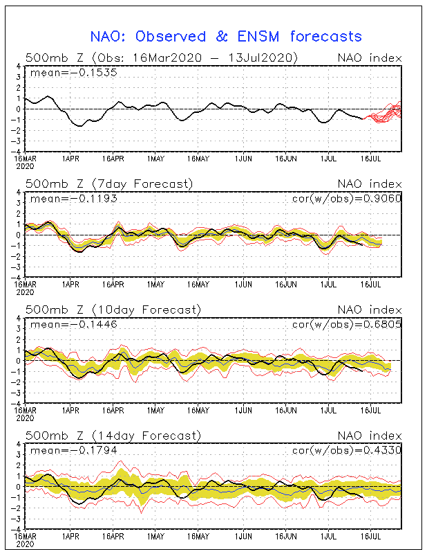
Looks like the NAO shows no sign of going positive, if anything it looks to stay the same or even is tending more negative. The more negative, the more chances storms would recurve possibly threatening Bermuda:

Image
0 likes   

AutoPenalti
Category 5
Category 5
Posts: 4030
Age: 29
Joined: Mon Aug 17, 2015 4:16 pm
Location: Ft. Lauderdale, Florida

Re: 2020 Indicators: SST's / SAL / MSLP / Steering / Shear / Instability / Sat Images

#1594 Postby AutoPenalti » Mon Jul 13, 2020 8:35 pm

gatorcane wrote:Looks like the NAO shows no sign of going positive, if anything it looks to stay the same or even is tending more negative. The more negative, the more chances storms would recurve possibly threatening Bermuda:

https://i.postimg.cc/dQxx21BM/nao-sprd2.gif

This can’t be used as a seasonal indicator though...
1 likes   
The posts in this forum are NOT official forecasts and should not be used as such. They are just the opinion of the poster and may or may not be backed by sound meteorological data. They are NOT endorsed by any professional institution or STORM2K. For official information, please refer to products from the NHC and NWS.


Model Runs Cheat Sheet:
GFS (5:30 AM/PM, 11:30 AM/PM)
HWRF, GFDL, UKMET, NAVGEM (6:30-8:00 AM/PM, 12:30-2:00 AM/PM)
ECMWF (1:45 AM/PM)

TCVN
is a weighted averaged

User avatar
DioBrando
Category 4
Category 4
Posts: 904
Age: 28
Joined: Sun Aug 12, 2018 12:45 pm

Re: 2020 Indicators: SST's / SAL / MSLP / Steering / Shear / Instability / Sat Images

#1595 Postby DioBrando » Mon Jul 13, 2020 9:55 pm

does this mean the ocean would be roasty toasty by the time the dust settles down and the shear relaxes?
:double:
0 likes   
blonde stacey (xe/xem/xir)

WeatherEmperor
S2K Supporter
S2K Supporter
Posts: 4806
Age: 41
Joined: Thu Sep 04, 2003 2:54 pm
Location: South Florida

Re: 2020 Indicators: SST's / SAL / MSLP / Steering / Shear / Instability / Sat Images

#1596 Postby WeatherEmperor » Mon Jul 13, 2020 10:15 pm

gatorcane wrote:Looks like the NAO shows no sign of going positive, if anything it looks to stay the same or even is tending more negative. The more negative, the more chances storms would recurve possibly threatening Bermuda:

[i.postimg.cc/dQxx21BM/nao-sprd2.gif[/img]


A negative NAO can be bad for Florida in Aug/Sept. Charley 2004 and Ernesto 2006 were pulled north out of the Caribbean into Florida due to stronger troughs because of negative NAO's. Some people argue that if Ernesto spent 24 hours longer over water, South Florida would have been hit by a Hurricane instead of a weak TS. With the Caribbean forecast to be much more favorable this year, I fear a negative NAO even more than a positive NAO living in South Florida. Dont forget October especially with cool neutral and possibly weak La Nina making the Caribbean a potential hot spot and Florida should always watch out for those conditions


Sent from my iPhone using Tapatalk
3 likes   

storminabox
Category 1
Category 1
Posts: 263
Joined: Sun Jul 09, 2017 10:50 pm

Re: 2020 Indicators: SST's / SAL / MSLP / Steering / Shear / Instability / Sat Images

#1597 Postby storminabox » Mon Jul 13, 2020 10:51 pm

captainbarbossa19 wrote:
MarioProtVI wrote:http://tropic.ssec.wisc.edu/real-time/atlantic/winds/wg8shr.GIF

Quite low for July standards especially the Caribbean :double: if this continues till the peak we could be in big trouble, which does align with some of the models.


That is very low shear. In previous years at this time, the Caribbean had generally unfavorable conditions. I don't like seeing the favorable conditions in the Gulf too. Today at my location, it is almost 100 degrees. The strong ridge nearby is causing very hot conditions, but I am concerned that it won't be here if a storm enters the Gulf later this year. I have seen some projections of the ridge shifting to the east coast later this summer. I have seen this happen before (2017 with Harvey).


If the Caribbean has favorable conditions, we are in trouble considering the boiling water temps. For the last few years, the Caribbean has generally been pretty unfavorable, but that doesn’t seem to be the case this year.
1 likes   

User avatar
Steve
S2K Supporter
S2K Supporter
Posts: 9621
Joined: Sat Apr 05, 2003 11:41 pm
Location: Not a state-caster

Re: 2020 Indicators: SST's / SAL / MSLP / Steering / Shear / Instability / Sat Images

#1598 Postby Steve » Mon Jul 13, 2020 11:27 pm

WeatherEmperor wrote:
gatorcane wrote:Looks like the NAO shows no sign of going positive, if anything it looks to stay the same or even is tending more negative. The more negative, the more chances storms would recurve possibly threatening Bermuda:

[i.postimg.cc/dQxx21BM/nao-sprd2.gif[/url]


A negative NAO can be bad for Florida in Aug/Sept. Charley 2004 and Ernesto 2006 were pulled north out of the Caribbean into Florida due to stronger troughs because of negative NAO's. Some people argue that if Ernesto spent 24 hours longer over water, South Florida would have been hit by a Hurricane instead of a weak TS. With the Caribbean forecast to be much more favorable this year, I fear a negative NAO even more than a positive NAO living in South Florida. Dont forget October especially with cool neutral and possibly weak La Nina making the Caribbean a potential hot spot and Florida should always watch out for those conditions


Sent from my iPhone using Tapatalk


It's been negative this month, and that isn't surprising. But it's mostly been neutral since mid-April except for that dip in May. Overall it's been slightly negative, but insignificant and more or less of a non-signal. MJO and the water temperature profiles look to me like they will be much more important signals. If, in fact, we get blocking high patterns, the highs are probably in New England, the eastern Great Lakes and south of there. That's actually a worse pattern for a lot of people in the Southeast and Bahamas because you don't have that same recurve potential west of 75W. IDK. I'm not doom and gloomer guy, but...

https://www.cpc.ncep.noaa.gov/products/ ... .sprd2.gif
0 likes   

User avatar
GCANE
S2K Supporter
S2K Supporter
Posts: 11497
Joined: Mon Oct 22, 2007 8:03 am

Re: 2020 Indicators: SST's / SAL / MSLP / Steering / Shear / Instability / Sat Images

#1599 Postby GCANE » Tue Jul 14, 2020 4:09 am

Rossby waves are starting to pull north for the season.
Two main Anticyclone Rossby Wave Breaks (ARWB) currently in the Atlantic.
Result is that shear is dropping quickly.
SAL just needs to settle down.
Latest wave is riding high, looks like it'll be a sweeper.


Image

Image

Image

Image

Image

Image
4 likes   

User avatar
HurricaneEnzo
Category 2
Category 2
Posts: 739
Joined: Wed Mar 14, 2018 12:18 pm
Location: Newport, NC (Hurricane Alley)

Re: 2020 Indicators: SST's / SAL / MSLP / Steering / Shear / Instability / Sat Images

#1600 Postby HurricaneEnzo » Tue Jul 14, 2020 6:13 am

MarioProtVI wrote:http://tropic.ssec.wisc.edu/real-time/atlantic/winds/wg8shr.GIF

Quite low for July standards especially the Caribbean :double: if this continues till the peak we could be in big trouble, which does align with some of the models.


Yeah that's a pretty stark contrast from the 60kts of shear we have become accustomed to in recent years :lol:
Last edited by HurricaneEnzo on Tue Jul 14, 2020 2:06 pm, edited 1 time in total.
3 likes   
Bertha 96' - Fran 96' - Bonnie 98' - Dennis 99' - Floyd 99' - Isabel 03' - Alex 04' - Ophelia 05' - Irene 11' - Arthur 14' - Matthew 16' - Florence 18' - Dorian 19' - Isaias 20' (countless other tropical storms and Hurricane swipes)

I am not a Professional Met just an enthusiast. Get your weather forecasts from the Pros!


Return to “Talkin' Tropics”

Who is online

Users browsing this forum: No registered users and 32 guests