2020 Indicators: SST's / SAL / MSLP / Steering / Shear / Instability / Sat Images

This is the general tropical discussion area. Anyone can take their shot at predicting a storms path.

Moderator: S2k Moderators

Forum rules

The posts in this forum are NOT official forecasts and should not be used as such. They are just the opinion of the poster and may or may not be backed by sound meteorological data. They are NOT endorsed by any professional institution or STORM2K. For official information, please refer to products from the National Hurricane Center and National Weather Service.

Help Support Storm2K
Message
Author
Aric Dunn
Category 5
Category 5
Posts: 21238
Age: 42
Joined: Sun Sep 19, 2004 9:58 pm
Location: Ready for the Chase.
Contact:

Re: 2020 Indicators: SST's / SAL / MSLP / Steering / Shear / Instability / Sat Images

#1761 Postby Aric Dunn » Sat Jul 18, 2020 3:12 pm

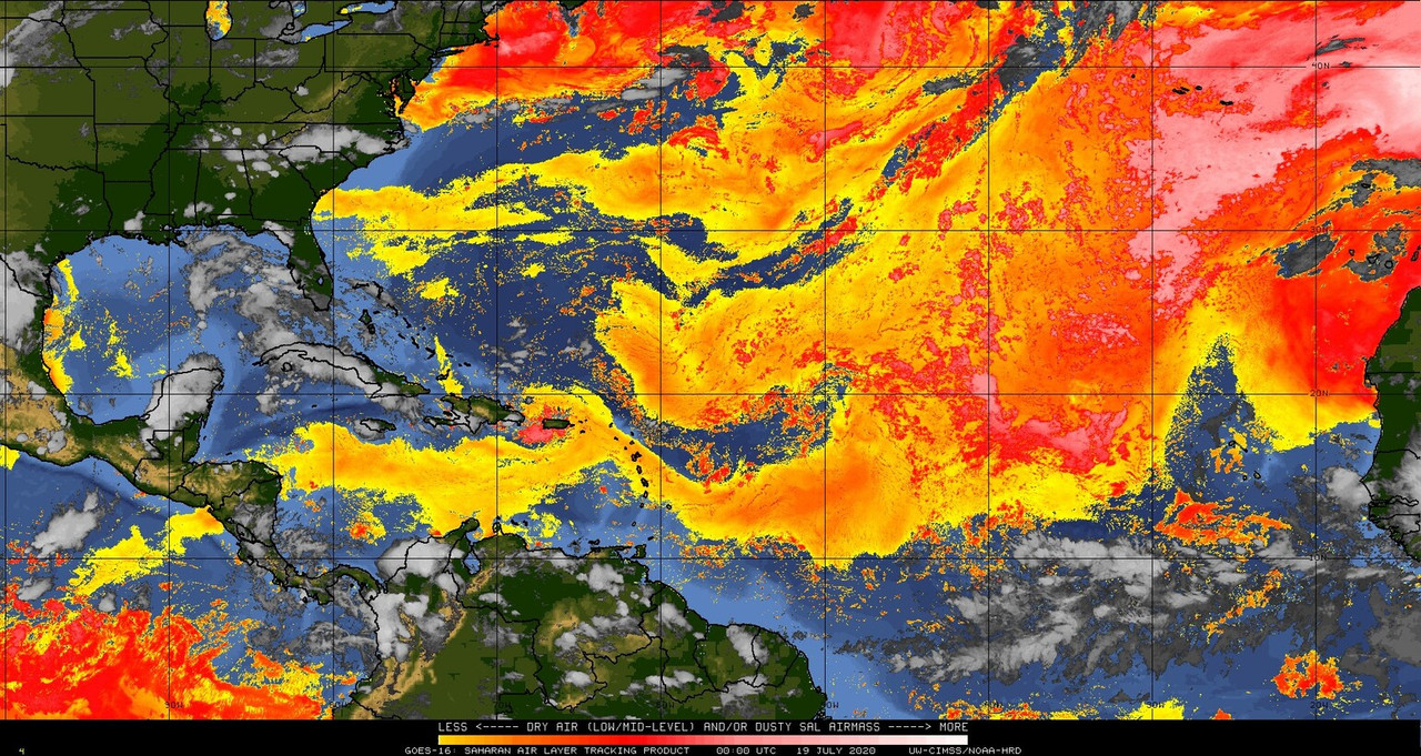
Hammy wrote:There's a nearly convection-free but clearly defined closed circulation near 50W--It seems that the low level conditions are significantly more favorable than in most recent years even at 20N so its now just a matter of the dry subsiding air clearing out.


Yeah it appears to be one of those years where there are Vort/Swirls all over the place.

and they can randomly develop if they find the right conditions.

similar to 2005.
5 likes   
Note: If I make a post that is brief. Please refer back to previous posts for the analysis or reasoning. I do not re-write/qoute what my initial post said each time.
If there is nothing before... then just ask :)

Space & Atmospheric Physicist, Embry-Riddle Aeronautical University,
I believe the sky is falling...

User avatar
aspen
Category 5
Category 5
Posts: 8818
Joined: Sat Oct 12, 2019 7:10 pm
Location: Connecticut, USA

Re: 2020 Indicators: SST's / SAL / MSLP / Steering / Shear / Instability / Sat Images

#1762 Postby aspen » Sat Jul 18, 2020 8:27 pm

The amount of warming in the tropical Atlantic over the last few days is insane. The MDR has shot up to a mean +0.59 C anomaly, while the Caribbean has warmed up even more to +0.716 C...and both were running 0.0-0.2 C above average before this week.
1 likes   
Irene '11 Sandy '12 Hermine '16 5/15/2018 Derecho Fay '20 Isaias '20 Elsa '21 Henri '21 Ida '21

I am only a meteorology enthusiast who knows a decent amount about tropical cyclones. Look to the professional mets, the NHC, or your local weather office for the best information.

User avatar
gatorcane
S2K Supporter
S2K Supporter
Posts: 23691
Age: 47
Joined: Sun Mar 13, 2005 3:54 pm
Location: Boca Raton, FL

Re: 2020 Indicators: SST's / SAL / MSLP / Steering / Shear / Instability / Sat Images

#1763 Postby gatorcane » Sat Jul 18, 2020 8:49 pm

The SAL is expansive as would be expected this time of year. The GFS continues to show dry air everywhere across the MDR for the foreseeable future:

Image
0 likes   

User avatar
cycloneye
Admin
Admin
Posts: 145349
Age: 68
Joined: Thu Oct 10, 2002 10:54 am
Location: San Juan, Puerto Rico

Re: 2020 Indicators: SST's / SAL / MSLP / Steering / Shear / Instability / Sat Images

#1764 Postby cycloneye » Sat Jul 18, 2020 8:50 pm

Also the MDR is leading the global tropics.

Image
0 likes   
Visit the Caribbean-Central America Weather Thread where you can find at first post web cams,radars
and observations from Caribbean basin members Click Here

User avatar
cycloneye
Admin
Admin
Posts: 145349
Age: 68
Joined: Thu Oct 10, 2002 10:54 am
Location: San Juan, Puerto Rico

Re: 2020 Indicators: SST's / SAL / MSLP / Steering / Shear / Instability / Sat Images

#1765 Postby cycloneye » Sat Jul 18, 2020 8:52 pm

This is the real one for Sal.

Image
11 likes   
Visit the Caribbean-Central America Weather Thread where you can find at first post web cams,radars
and observations from Caribbean basin members Click Here

User avatar
toad strangler
S2K Supporter
S2K Supporter
Posts: 4543
Joined: Sun Jul 28, 2013 3:09 pm
Location: Earth
Contact:

Re: 2020 Indicators: SST's / SAL / MSLP / Steering / Shear / Instability / Sat Images

#1766 Postby toad strangler » Sat Jul 18, 2020 9:00 pm

cycloneye wrote:This is the real one for Sal.

https://i.imgur.com/xfZ1fHN.jpg


Indeed, SAL is pretty scattershot in coverage now away from the immediate African coast / Cabo Verde area.
0 likes   

Aric Dunn
Category 5
Category 5
Posts: 21238
Age: 42
Joined: Sun Sep 19, 2004 9:58 pm
Location: Ready for the Chase.
Contact:

Re: 2020 Indicators: SST's / SAL / MSLP / Steering / Shear / Instability / Sat Images

#1767 Postby Aric Dunn » Sat Jul 18, 2020 9:13 pm

toad strangler wrote:
cycloneye wrote:This is the real one for Sal.

https://i.imgur.com/xfZ1fHN.jpg


Indeed, SAL is pretty scattershot in coverage now away from the immediate African coast / Cabo Verde area.


SAL producing regions had some rain the last couple weeks. overall moisture will continue to increase across the MDR
6 likes   
Note: If I make a post that is brief. Please refer back to previous posts for the analysis or reasoning. I do not re-write/qoute what my initial post said each time.
If there is nothing before... then just ask :)

Space & Atmospheric Physicist, Embry-Riddle Aeronautical University,
I believe the sky is falling...

USTropics
Professional-Met
Professional-Met
Posts: 2651
Joined: Sun Aug 12, 2007 3:45 am
Location: Florida State University

Re: 2020 Indicators: SST's / SAL / MSLP / Steering / Shear / Instability / Sat Images

#1768 Postby USTropics » Sun Jul 19, 2020 4:44 am

Something to take notice of, over the past 30 runs of the CFS, there has been a slow correction for August VP anomalies propagation towards Africa:

Image
2 likes   

User avatar
NDG
S2K Supporter
S2K Supporter
Posts: 15446
Joined: Sun Jul 09, 2006 10:14 pm
Location: Orlando, FL

Re: 2020 Indicators: SST's / SAL / MSLP / Steering / Shear / Instability / Sat Images

#1769 Postby NDG » Sun Jul 19, 2020 6:45 am

Aric Dunn wrote:
toad strangler wrote:
cycloneye wrote:This is the real one for Sal.

https://i.imgur.com/xfZ1fHN.jpg


Indeed, SAL is pretty scattershot in coverage now away from the immediate African coast / Cabo Verde area.


SAL producing regions had some rain the last couple weeks. overall moisture will continue to increase across the MDR


Indeed, compared to just a few days ago dust has really come down some, but there's another one being forecasted next week but nothing close to earlier in the month, the western Atlantic Basin is mostly clear of any dust.

Image
Image
6 likes   

User avatar
cycloneye
Admin
Admin
Posts: 145349
Age: 68
Joined: Thu Oct 10, 2002 10:54 am
Location: San Juan, Puerto Rico

Re: 2020 Indicators: SST's / SAL / MSLP / Steering / Shear / Instability / Sat Images

#1770 Postby cycloneye » Sun Jul 19, 2020 8:15 am

0 likes   
Visit the Caribbean-Central America Weather Thread where you can find at first post web cams,radars
and observations from Caribbean basin members Click Here

User avatar
toad strangler
S2K Supporter
S2K Supporter
Posts: 4543
Joined: Sun Jul 28, 2013 3:09 pm
Location: Earth
Contact:

Re: 2020 Indicators: SST's / SAL / MSLP / Steering / Shear / Instability / Sat Images

#1771 Postby toad strangler » Sun Jul 19, 2020 9:39 am

USTropics wrote:Something to take notice of, over the past 30 runs of the CFS, there has been a slow correction for August VP anomalies propagation towards Africa:

https://i.ibb.co/KFZLPVw/cfs-mon-01-chi200-global-fh1-trend-4.gif


Meaning?
1 likes   

User avatar
SFLcane
S2K Supporter
S2K Supporter
Posts: 10163
Age: 47
Joined: Sat Jun 05, 2010 1:44 pm
Location: Lake Worth Florida

Re: 2020 Indicators: SST's / SAL / MSLP / Steering / Shear / Instability / Sat Images

#1772 Postby SFLcane » Sun Jul 19, 2020 9:48 am

toad strangler wrote:
USTropics wrote:Something to take notice of, over the past 30 runs of the CFS, there has been a slow correction for August VP anomalies propagation towards Africa:

https://i.ibb.co/KFZLPVw/cfs-mon-01-chi200-global-fh1-trend-4.gif


Meaning?


Hi Toad,

It's correcting towards a less hostile look.
5 likes   

User avatar
NDG
S2K Supporter
S2K Supporter
Posts: 15446
Joined: Sun Jul 09, 2006 10:14 pm
Location: Orlando, FL

Re: 2020 Indicators: SST's / SAL / MSLP / Steering / Shear / Instability / Sat Images

#1773 Postby NDG » Sun Jul 19, 2020 9:49 am

There's definitely not a drop of dust in the western basin right now, nice tropical clean skies over central FL.

Image
13 likes   

AutoPenalti
Category 5
Category 5
Posts: 4030
Age: 29
Joined: Mon Aug 17, 2015 4:16 pm
Location: Ft. Lauderdale, Florida

Re: 2020 Indicators: SST's / SAL / MSLP / Steering / Shear / Instability / Sat Images

#1774 Postby AutoPenalti » Sun Jul 19, 2020 10:16 am

SFLcane wrote:
toad strangler wrote:
USTropics wrote:Something to take notice of, over the past 30 runs of the CFS, there has been a slow correction for August VP anomalies propagation towards Africa:

https://i.ibb.co/KFZLPVw/cfs-mon-01-chi200-global-fh1-trend-4.gif


Meaning?


Hi Toad,

It's correcting towards a less hostile look.

It seems relatively the same to me, I could be wrong.
0 likes   
The posts in this forum are NOT official forecasts and should not be used as such. They are just the opinion of the poster and may or may not be backed by sound meteorological data. They are NOT endorsed by any professional institution or STORM2K. For official information, please refer to products from the NHC and NWS.


Model Runs Cheat Sheet:
GFS (5:30 AM/PM, 11:30 AM/PM)
HWRF, GFDL, UKMET, NAVGEM (6:30-8:00 AM/PM, 12:30-2:00 AM/PM)
ECMWF (1:45 AM/PM)

TCVN
is a weighted averaged

IsabelaWeather
Category 1
Category 1
Posts: 287
Age: 36
Joined: Tue Jul 07, 2020 7:29 am
Location: Isabela, Puerto Rico

Re: 2020 Indicators: SST's / SAL / MSLP / Steering / Shear / Instability / Sat Images

#1775 Postby IsabelaWeather » Sun Jul 19, 2020 10:42 am

NDG wrote:There's definitely not a drop of dust in the western basin right now, nice tropical clean skies over central FL.

https://i.imgur.com/27JE9dI.jpg


Image
Nothing in the central atlantic either. Havent had any dust in quite some time :sun:
14 likes   

hurricanes1234
Category 5
Category 5
Posts: 2907
Joined: Sat Jul 28, 2012 6:19 pm
Location: Trinidad and Tobago

Re: 2020 Indicators: SST's / SAL / MSLP / Steering / Shear / Instability / Sat Images

#1776 Postby hurricanes1234 » Sun Jul 19, 2020 11:09 am

Same here in T&T. This week is the first time in maybe weeks that I can actually look up into a clear, blue sky (and not a white sky, a light brown sky, a bluish-brown sky, etc).
:lol:
7 likes   
PLEASE NOTE: With the exception of information from weather agencies that I may copy and paste here, my posts will NEVER be official, since I am NOT a meteorologist. They are solely my amateur opinion, and may or may not be accurate. Therefore, please DO NOT use them as official details, particularly when making important decisions. Thank you.

User avatar
abajan
S2K Supporter
S2K Supporter
Posts: 4233
Joined: Sun Sep 07, 2003 5:10 am
Location: Barbados

Re: 2020 Indicators: SST's / SAL / MSLP / Steering / Shear / Instability / Sat Images

#1777 Postby abajan » Sun Jul 19, 2020 11:43 am

hurricanes1234 wrote:Same here in T&T. This week is the first time in maybe weeks that I can actually look up into a clear, blue sky (and not a white sky, a light brown sky, a bluish-brown sky, etc).
:lol:

Ditto for Barbados. :sun:
5 likes   

User avatar
cycloneye
Admin
Admin
Posts: 145349
Age: 68
Joined: Thu Oct 10, 2002 10:54 am
Location: San Juan, Puerto Rico

Re: 2020 Indicators: SST's / SAL / MSLP / Steering / Shear / Instability / Sat Images

#1778 Postby cycloneye » Sun Jul 19, 2020 12:38 pm

In the past four days it has been a clear blue sky here in Puerto Rico.

Image
9 likes   
Visit the Caribbean-Central America Weather Thread where you can find at first post web cams,radars
and observations from Caribbean basin members Click Here

TheStormExpert

Re: 2020 Indicators: SST's / SAL / MSLP / Steering / Shear / Instability / Sat Images

#1779 Postby TheStormExpert » Sun Jul 19, 2020 1:14 pm

0 likes   

User avatar
Hammy
Category 5
Category 5
Posts: 5849
Age: 41
Joined: Fri May 25, 2012 5:25 pm
Contact:

Re: 2020 Indicators: SST's / SAL / MSLP / Steering / Shear / Instability / Sat Images

#1780 Postby Hammy » Sun Jul 19, 2020 1:37 pm

TheStormExpert wrote:Take this into consideration.

https://twitter.com/derekortt/status/1284908629615935489


The GFS has had a terrible history over the last few years in the Atlantic, with some exceptions obviously, of under-developing or simply not developing systems until a few days before they actually form--so this wouldn't surprise me in the least. I think they over-corrected the problem that was causing the Atlantic phantom storms.
6 likes   
The above post is not official and should not be used as such. It is the opinion of the poster and may or may not be backed by sound meteorological data. It is not endorsed by any professional institution or storm2k.org. For official information, please refer to the NHC and NWS products.


Return to “Talkin' Tropics”

Who is online

Users browsing this forum: Killjoy12, Pas_Bon and 35 guests