JB with his thing.
https://twitter.com/BigJoeBastardi/status/1285583935393628161
2020 Indicators: SST's / SAL / MSLP / Steering / Shear / Instability / Sat Images
Moderator: S2k Moderators
Forum rules

The posts in this forum are NOT official forecasts and should not be used as such. They are just the opinion of the poster and may or may not be backed by sound meteorological data. They are NOT endorsed by any professional institution or STORM2K. For official information, please refer to products from the National Hurricane Center and National Weather Service.
-
cycloneye

- Admin

- Posts: 149438
- Age: 69
- Joined: Thu Oct 10, 2002 10:54 am
- Location: San Juan, Puerto Rico
Re: 2020 Indicators: SST's / SAL / MSLP / Steering / Shear / Instability / Sat Images
0 likes
Visit the Caribbean-Central America Weather Thread where you can find at first post web cams,radars
and observations from Caribbean basin members Click Here
and observations from Caribbean basin members Click Here
-
Evan_Wilson
- Tropical Low

- Posts: 25
- Joined: Tue May 26, 2020 1:09 pm
Re: 2020 Indicators: SST's / SAL / MSLP / Steering / Shear / Instability / Sat Images
I know steering currents are hard to predict, but when does it appear that the blocking pattern becomes favorable for East Coast landfalls?
0 likes

Re: 2020 Indicators: SST's / SAL / MSLP / Steering / Shear / Instability / Sat Images
Evan_Wilson wrote:I know steering currents are hard to predict, but when does it appear that the blocking pattern becomes favorable for East Coast landfalls?
We're essentially there now. Granted, there will always be fluctuation in 500mb heights but as things stand now mid level steering is largely in place and without any East coast troughing to be seen. Next month will likely show even stronger West Atlantic heights which may result in a few Caribbean long tracks, but also pose potential risk to Florida and all the way north to the Northeast U.S. for those storms that may form at somewhat higher latitudes and that track near or just north of Puerto Rico. These would likely be such storms that might pose the greatest risk to impacting the U.S. seaboard over the next few weeks. I think that risk will increase toward the end of August/beginning of September as western Atlantic mid level heights wane somewhat thus influencing a bit more of a earlier poleward track as tropical cyclones traverse into the W. Atlantic. What'll be key at that precise time is the overall orientation of the 500mb pattern, whether high pressure over the Eastern U.S. appears to be bridging with high pressure over the West Atlantic, and of course where any digging short waves are located suggesting a weakness forming in the ridge (thus resulting in a more poleward turn near/at that point.
https://www.tropicaltidbits.com/analysi ... 72112&fh=6
2 likes
Andy D
(For official information, please refer to the NHC and NWS products.)
(For official information, please refer to the NHC and NWS products.)

-
HurricaneEnzo

- Category 2

- Posts: 743
- Joined: Wed Mar 14, 2018 12:18 pm
- Location: Newport, NC (Hurricane Alley)
Re: 2020 Indicators: SST's / SAL / MSLP / Steering / Shear / Instability / Sat Images
One thing that has stuck out to me so far this season is that although most of our development has been on the short lived weaker side ever since the first storm was named we have been getting storms ever since at a consistent pace.
Some seasons you might see some pre/early season formation followed by long lulls in activity. The middle of June was a little on the quiet side but overall we have been churning out storms since May. Not really rooted in any science but I just felt this was a harbinger of bad things to come. It at least looks currently like things could get wild during peak season.
Some seasons you might see some pre/early season formation followed by long lulls in activity. The middle of June was a little on the quiet side but overall we have been churning out storms since May. Not really rooted in any science but I just felt this was a harbinger of bad things to come. It at least looks currently like things could get wild during peak season.
0 likes
Bertha 96' - Fran 96' - Bonnie 98' - Dennis 99' - Floyd 99' - Isabel 03' - Alex 04' - Ophelia 05' - Irene 11' - Arthur 14' - Matthew 16' - Florence 18' - Dorian 19' - Isaias 20' (countless other tropical storms and Hurricane swipes)
I am not a Professional Met just an enthusiast. Get your weather forecasts from the Pros!
I am not a Professional Met just an enthusiast. Get your weather forecasts from the Pros!
Re: 2020 Indicators: SST's / SAL / MSLP / Steering / Shear / Instability / Sat Images
Impatience does not = unfavorable
Mt St Helens took a couple months of rumbling before it blew its top. The basin is rumbling awake like a long dormant volcano. Some things just take time.
Mt St Helens took a couple months of rumbling before it blew its top. The basin is rumbling awake like a long dormant volcano. Some things just take time.
2 likes
-
EquusStorm
- Category 5

- Posts: 1649
- Age: 35
- Joined: Thu Nov 07, 2013 1:04 pm
- Location: Jasper, AL
- Contact:
Re: 2020 Indicators: SST's / SAL / MSLP / Steering / Shear / Instability / Sat Images
Yeah the early activity is certainly intriguing. A satellite loop of a given hurricane season will show that there are usually a bunch of mid latitude early systems that try, struggle, and maybe get a 30 on the TWO but die off. This year has about the same number but almost EVERYTHING that's tried has succeeded, which certainly seems a little ominous. Reminder that we almost had a subtropical depression in the central Atlantic right before Cristobal which would have been THREE cyclones for May. It's been a fascinating season to track already
4 likes
Colors of lost purpose on the canvas of irrelevance
Not a meteorologist, in fact more of an idiot than anything. You should probably check with the NHC or a local NWS office for official information.
Not a meteorologist, in fact more of an idiot than anything. You should probably check with the NHC or a local NWS office for official information.
-
Aric Dunn
- Category 5
- Posts: 21238
- Age: 43
- Joined: Sun Sep 19, 2004 9:58 pm
- Location: Ready for the Chase.
- Contact:
Re: 2020 Indicators: SST's / SAL / MSLP / Steering / Shear / Instability / Sat Images
Here is an indicator..
you know things are getting bad when the Euro develops a TC in the eastern cariib.. the graveyard.. the death cap... the beginning and the end.. lol

you know things are getting bad when the Euro develops a TC in the eastern cariib.. the graveyard.. the death cap... the beginning and the end.. lol
4 likes
Note: If I make a post that is brief. Please refer back to previous posts for the analysis or reasoning. I do not re-write/qoute what my initial post said each time.
If there is nothing before... then just ask
Space & Atmospheric Physicist, Embry-Riddle Aeronautical University,
I believe the sky is falling...
If there is nothing before... then just ask
Space & Atmospheric Physicist, Embry-Riddle Aeronautical University,
I believe the sky is falling...

Re: 2020 Indicators: SST's / SAL / MSLP / Steering / Shear / Instability / Sat Images
TD-7 will likely beat Gert ‘05 to become the earliest seventh named storm in the Atlantic basin. At this rate, Harvey ‘05 will likely fall as well, and I don’t think Irene ‘05 is safe either. It all depends on which develops first: Invest 91L, or that AEW forecast to move off the African coast on Friday/Saturday. I’m a little doubtful that 91L will get named; I have more faith in the AEW developing next week. Either way, if any of these form, it will beat out Harvey ‘05.
1 likes
Irene '11 Sandy '12 Hermine '16 5/15/2018 Derecho Fay '20 Isaias '20 Elsa '21 Henri '21 Ida '21
I am only a meteorology enthusiast who knows a decent amount about tropical cyclones. Look to the professional mets, the NHC, or your local weather office for the best information.
I am only a meteorology enthusiast who knows a decent amount about tropical cyclones. Look to the professional mets, the NHC, or your local weather office for the best information.
-
CyclonicFury

- Category 5
- Posts: 2033
- Age: 27
- Joined: Sun Jul 02, 2017 12:32 pm
- Location: NC
- Contact:
Re: 2020 Indicators: SST's / SAL / MSLP / Steering / Shear / Instability / Sat Images
Shell Mound wrote:Top six hyperactive Atlantic seasons and earliest formation date* in MDR (satellite era)
2005 – 11 Jul
1995 – 12 Jul
2004 – 3 Aug
2017 – 19 Jun
1961 – 17 Jul
1998 – 27 Jul
*TD or stronger
So only ~17% or one-sixth of these years (2004) comprised an exception. All five others had at least a TD in the MDR prior to August.
If we don’t see at least one TD (preferably TS) in the MDR before August, then the forecasts for a hyperactive year may bust.
The main problem is that SSTs, on average, have been too cool over the past few months for instability to enable TC formation.
Of course, I am referring to SSTs in the MDR.
https://twitter.com/TylerJStanfield/status/1284837592874266624
2020 - 21 Jul
12 likes
NCSU B.S. in Meteorology Class of 2021. Tropical weather blogger at http://www.cyclonicfury.com. My forecasts and thoughts are NOT official, for official forecasts please consult the National Hurricane Center.
-
EquusStorm
- Category 5
- Posts: 1649
- Age: 35
- Joined: Thu Nov 07, 2013 1:04 pm
- Location: Jasper, AL
- Contact:
Re: 2020 Indicators: SST's / SAL / MSLP / Steering / Shear / Instability / Sat Images
The thing with 2005's records is, we had a big August lull between Irene and Jose, so if we're already this far ahead and have an active August, we could pull significantly ahead. It may seem impossible to beat much more of 2005's formation records, but 2011 tied it for earliest 13th named storm with 2012 only a few days behind, so it's certainly not impossible. 2005 only pulled WAY ahead of every other season in October; let's hope we aren't still challenging it then!
5 likes
Colors of lost purpose on the canvas of irrelevance
Not a meteorologist, in fact more of an idiot than anything. You should probably check with the NHC or a local NWS office for official information.
Not a meteorologist, in fact more of an idiot than anything. You should probably check with the NHC or a local NWS office for official information.
-
TheHurricaneGod
- Tropical Storm

- Posts: 165
- Age: 23
- Joined: Thu Apr 16, 2020 6:19 pm
- Location: Fort Lauderdale
Re: 2020 Indicators: SST's / SAL / MSLP / Steering / Shear / Instability / Sat Images
The major global models are showing a relaxation in the big heat in the east coast as a strong ridge finally retrogrades west by the end of the month. I am eyeing the potential for a return of cutoff lows that may hang around in the east coast for a few days at a time, a repeat of the pattern that dominated the east coast in May and June. This will likely increase the threat of tropical systems making landfall in the southeast/east coast of the U.S along with a somewhat blocky pattern in Atlantic Canada in early August to prevent recurvatures if it's in the right spot.
Notice that there were a lot of systems tracking off the east coast in late spring. This was due to cutoff lows bringing tropical lows close to the east coast. If this kind of pattern returns in early August, which it has a good possibility of doing so, be worried for potential significant impacts in the EC of the US as well as the Gulf Coast if we get any strong tropical cyclones with the correct steering.
I believe this same kind of pattern brought Hugo in to slam the southeast coast in 1989.
1 likes
-
gatorcane

- S2K Supporter

- Posts: 23708
- Age: 48
- Joined: Sun Mar 13, 2005 3:54 pm
- Location: Boca Raton, FL
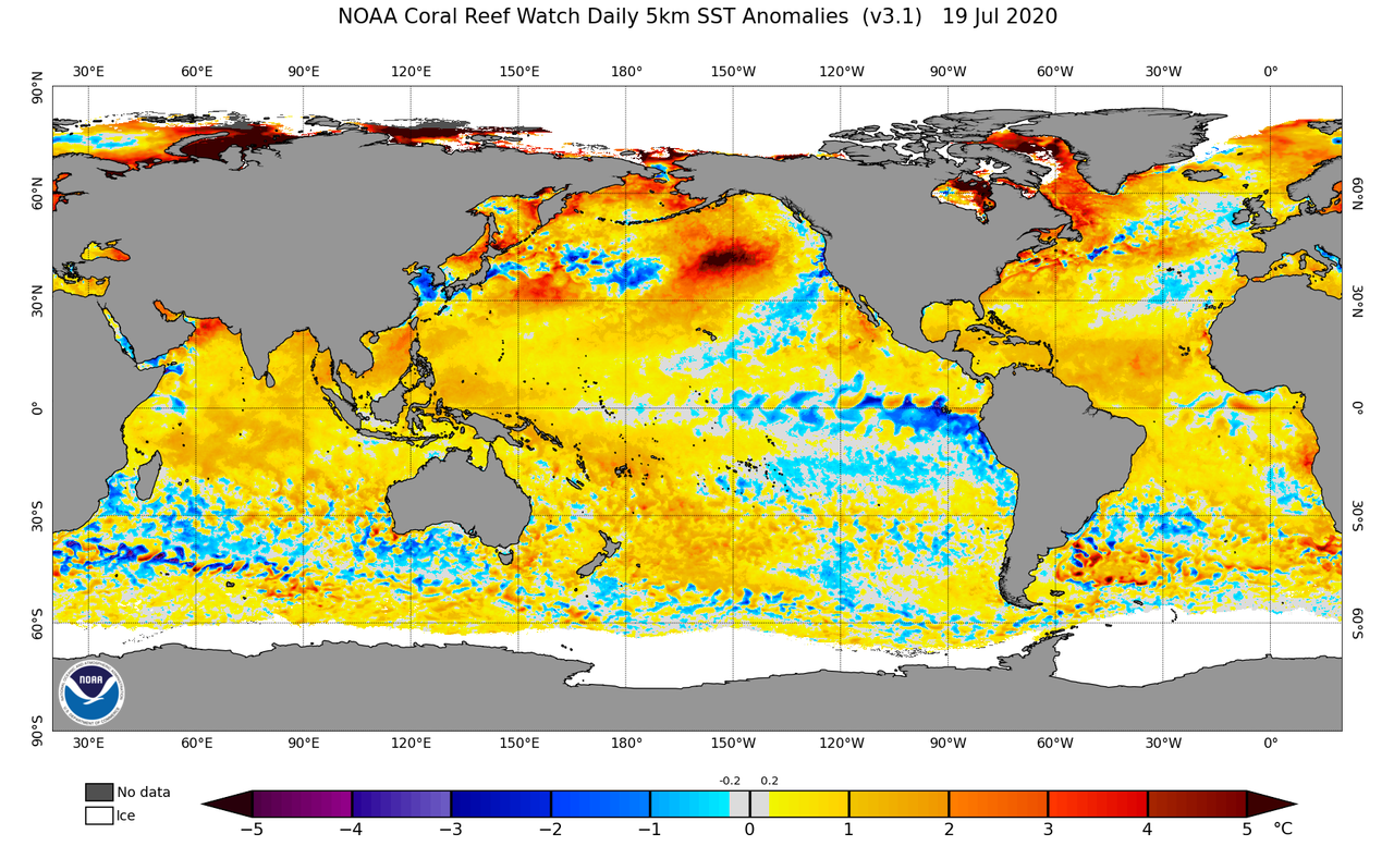
Re: 2020 Indicators: SST's / SAL / MSLP / Steering / Shear / Instability / Sat Images
Latest SST anomalies. Looks rather warm in the MDR:
3 likes

Re: 2020 Indicators: SST's / SAL / MSLP / Steering / Shear / Instability / Sat Images
1 likes
Georges '98, Irene '99, Frances '04, Jeanne '04, Katrina '05, Wilma '05, Gustav '08, Isaac '12, Matthew '16, Florence '18, Michael '18, Ian '22
-
SconnieCane
- Category 5
- Posts: 1013
- Joined: Thu Aug 02, 2018 5:29 pm
- Location: Madison, WI
Re: 2020 Indicators: SST's / SAL / MSLP / Steering / Shear / Instability / Sat Images
So...
July 22nd and we have a newly named TS in the MDR looking good and forecast to become a hurricane.
We have an organizing warm core low pressure system in the Gulf, possibly on the verge of becoming a depression if not a TS.
On top of that, we have another wave with model support for development moving off of Africa in the coming days.
It's almost like the Atlantic Ocean and the atmosphere above it decided to time skip forward by about 35-40 days.
6 likes
-
Shell Mound
- Category 5
- Posts: 2432
- Age: 33
- Joined: Thu Sep 07, 2017 3:39 pm
- Location: St. Petersburg, FL → Scandinavia
Re: 2020 Indicators: SST's / SAL / MSLP / Steering / Shear / Instability / Sat Images
https://twitter.com/webberweather/status/1285944854300762116
https://twitter.com/webberweather/status/1285946487822852099
https://twitter.com/splillo/status/1285935065671688192
https://twitter.com/splillo/status/1285941044454977537
https://twitter.com/splillo/status/1285949982797787136
https://twitter.com/webberweather/status/1285946487822852099
https://twitter.com/splillo/status/1285935065671688192
https://twitter.com/splillo/status/1285941044454977537
https://twitter.com/splillo/status/1285949982797787136
0 likes
CVW / MiamiensisWx / Shell Mound
The posts in this forum are NOT official forecasts and should not be used as such. They are just the opinion of the poster and may or may not be backed by sound meteorological data. They are NOT endorsed by any professional institution or STORM2K. For official information, please refer to products from the NHC and NWS.
-
StruThiO

- Category 3

- Posts: 821
- Age: 26
- Joined: Fri Sep 15, 2017 5:51 am
- Location: Currently Portland, OR. Raised in Jax, FL.
Re: 2020 Indicators: SST's / SAL / MSLP / Steering / Shear / Instability / Sat Images
This season is already becoming uncomfortable..
Everything everywhere wants to develop AND to add insult to injury the models seem to be playing catchup every time
Everything everywhere wants to develop AND to add insult to injury the models seem to be playing catchup every time
7 likes
Re: 2020 Indicators: SST's / SAL / MSLP / Steering / Shear / Instability / Sat Images
There's quite a bit to look at when we're entitled to nothing. The seasonal no man's land...which i like to call the "moat"...is being bridged. It's like the atlantic basin is diet coke and we're dumping mentos. crikey..
6 likes
-
TheHurricaneGod
- Tropical Storm
- Posts: 165
- Age: 23
- Joined: Thu Apr 16, 2020 6:19 pm
- Location: Fort Lauderdale
Re: 2020 Indicators: SST's / SAL / MSLP / Steering / Shear / Instability / Sat Images
StruThiO wrote:This season is already becoming uncomfortable..
Everything everywhere wants to develop AND to add insult to injury the models seem to be playing catchup every time
From dead quiet to active with the snap of a finger.
1 likes
Who is online
Users browsing this forum: Google [Bot] and 169 guests