ATL: HANNA - Remnants - Discussion
Moderator: S2k Moderators

Re: ATL: INVEST 91L - Discussion
Slowing down the forecast a little sounded like a possible stall till Sunday landfall under that building high?
0 likes
-
HurricaneEnzo

- Category 2

- Posts: 743
- Joined: Wed Mar 14, 2018 12:18 pm
- Location: Newport, NC (Hurricane Alley)
Re: ATL: INVEST 91L - Discussion
Wrong thread
Last edited by HurricaneEnzo on Wed Jul 22, 2020 7:49 pm, edited 1 time in total.
0 likes
Bertha 96' - Fran 96' - Bonnie 98' - Dennis 99' - Floyd 99' - Isabel 03' - Alex 04' - Ophelia 05' - Irene 11' - Arthur 14' - Matthew 16' - Florence 18' - Dorian 19' - Isaias 20' (countless other tropical storms and Hurricane swipes)
I am not a Professional Met just an enthusiast. Get your weather forecasts from the Pros!
I am not a Professional Met just an enthusiast. Get your weather forecasts from the Pros!
-
NXStumpy_Robothing
- Category 1

- Posts: 335
- Age: 25
- Joined: Fri Jun 05, 2020 11:50 pm
- Location: North Georgia
Re: ATL: INVEST 91L - Discussion
HurricaneEnzo wrote:http://tropic.ssec.wisc.edu/real-time/sal/g16split/movies/goes16split.html
SAL is bearing down on Gonzalo and he is starting to lose the battle. But at the same time he is also getting closer to better conditions as most of the SAL has passed him by.
Just a little bit more to deal with but the only way out is through. If he can hold on a while longer might have a chance for bigger things.
Sent from my SM-N975U using Tapatalk
I believe you posted this in the wrong thread. Insightful to see the SAL-Gonzalo interactions, though.
0 likes
Undergraduate Meteorology Student, Georgia Institute of Technology
-
cycloneye

- Admin

- Posts: 149286
- Age: 69
- Joined: Thu Oct 10, 2002 10:54 am
- Location: San Juan, Puerto Rico
Re: ATL: INVEST 91L - Discussion
PTC at 11.
Potential Tropical Cyclone EIGHT
As of 00:00 UTC Jul 23, 2020:
Location: 25.7°N 87.9°W
Maximum Winds: 25 kt Gusts: 35 kt
Minimum Central Pressure: 1009 mb
Environmental Pressure: 1012 mb
Radius of Circulation: 120 NM
Radius of Maximum Wind: 40 NM
Potential Tropical Cyclone EIGHT
As of 00:00 UTC Jul 23, 2020:
Location: 25.7°N 87.9°W
Maximum Winds: 25 kt Gusts: 35 kt
Minimum Central Pressure: 1009 mb
Environmental Pressure: 1012 mb
Radius of Circulation: 120 NM
Radius of Maximum Wind: 40 NM
5 likes
Visit the Caribbean-Central America Weather Thread where you can find at first post web cams,radars
and observations from Caribbean basin members Click Here
and observations from Caribbean basin members Click Here

Re: ATL: INVEST 91L - Discussion
It’s PTC-8 on Tropical Tidbits
0 likes
Irene '11 Sandy '12 Hermine '16 5/15/2018 Derecho Fay '20 Isaias '20 Elsa '21 Henri '21 Ida '21
I am only a meteorology enthusiast who knows a decent amount about tropical cyclones. Look to the professional mets, the NHC, or your local weather office for the best information.
I am only a meteorology enthusiast who knows a decent amount about tropical cyclones. Look to the professional mets, the NHC, or your local weather office for the best information.
Re: ATL: INVEST 91L - Discussion
aspen wrote:It’s PTC-8 on Tropical Tidbits
The high cirrus in the water vapor loop.
https://www.tropicaltidbits.com/sat/sat ... uct=wv-mid
0 likes
-
northjaxpro

- S2K Supporter

- Posts: 8900
- Joined: Mon Sep 27, 2010 11:21 am
- Location: Jacksonville, FL
Re: ATL: INVEST 91L - Discussion: Breaking News= PTC at 11 PM
Smart move by NHC to post the PTC advisory this evening!
1 likes
NEVER, EVER SAY NEVER in the tropics and weather in general, and most importantly, with life itself!!
________________________________________________________________________________________
Fay 2008 Beryl 2012 Debby 2012 Colin 2016 Hermine 2016 Julia 2016 Matthew 2016 Irma 2017 Dorian 2019
________________________________________________________________________________________
Fay 2008 Beryl 2012 Debby 2012 Colin 2016 Hermine 2016 Julia 2016 Matthew 2016 Irma 2017 Dorian 2019
Re: ATL: INVEST 91L - Discussion: Breaking News= PTC at 11 PM
Last visible shots for the day... will be interesting to see how PTC 8 evolves tomorrow.

0 likes
-
sphelps8681
- Category 2
- Posts: 785
- Joined: Thu Aug 16, 2007 5:37 pm
- Location: Somewhere over the rainbow
Re: ATL: INVEST 91L - Discussion
cycloneye wrote:PTC at 11.
Potential Tropical Cyclone EIGHT
As of 00:00 UTC Jul 23, 2020:
Location: 25.7°N 87.9°W
Maximum Winds: 25 kt Gusts: 35 kt
Minimum Central Pressure: 1009 mb
Environmental Pressure: 1012 mb
Radius of Circulation: 120 NM
Radius of Maximum Wind: 40 NM
I am sorry where would this be located?
0 likes
Re: ATL: INVEST 91L - Discussion
Nimbus wrote:aspen wrote:It’s PTC-8 on Tropical Tidbits
The high cirrus in the water vapor loop.
https://www.tropicaltidbits.com/sat/sat ... uct=wv-mid
That’s a lot of moisture for PTC-8 to work with. It’ll also be over water for 48-72 hours. The biggest issue will be how broad the circulation is, which can be seen in that WV loop.
0 likes
Irene '11 Sandy '12 Hermine '16 5/15/2018 Derecho Fay '20 Isaias '20 Elsa '21 Henri '21 Ida '21
I am only a meteorology enthusiast who knows a decent amount about tropical cyclones. Look to the professional mets, the NHC, or your local weather office for the best information.
I am only a meteorology enthusiast who knows a decent amount about tropical cyclones. Look to the professional mets, the NHC, or your local weather office for the best information.
-
cycloneye
- Admin
- Posts: 149286
- Age: 69
- Joined: Thu Oct 10, 2002 10:54 am
- Location: San Juan, Puerto Rico
Re: ATL: INVEST 91L - Discussion
sphelps8681 wrote:cycloneye wrote:PTC at 11.
Potential Tropical Cyclone EIGHT
As of 00:00 UTC Jul 23, 2020:
Location: 25.7°N 87.9°W
Maximum Winds: 25 kt Gusts: 35 kt
Minimum Central Pressure: 1009 mb
Environmental Pressure: 1012 mb
Radius of Circulation: 120 NM
Radius of Maximum Wind: 40 NM
I am sorry where would this be located?
Here is the link to tropical tidbits.
https://www.tropicaltidbits.com/storminfo/
1 likes
Visit the Caribbean-Central America Weather Thread where you can find at first post web cams,radars
and observations from Caribbean basin members Click Here
and observations from Caribbean basin members Click Here
-
cycloneye
- Admin
- Posts: 149286
- Age: 69
- Joined: Thu Oct 10, 2002 10:54 am
- Location: San Juan, Puerto Rico
Re: ATL: INVEST 91L - Discussion: Breaking News= PTC at 11 PM
Here is the transition of the 00z best track from 91L to 08L.
AL, 08, 2020072300, , BEST, 0, 257N, 879W, 25, 1009, LO, 34, NEQ, 0, 0, 0, 0, 1012, 120, 40, 35, 0, L, 0, , 0, 0, INVEST, S, 0, , 0, 0, 0, 0, genesis-num, 018, TRANSITIONED, alC12020 to al082020,
0 likes
Visit the Caribbean-Central America Weather Thread where you can find at first post web cams,radars
and observations from Caribbean basin members Click Here
and observations from Caribbean basin members Click Here
Re: ATL: INVEST 91L - Discussion
aspen wrote:Nimbus wrote:aspen wrote:It’s PTC-8 on Tropical Tidbits
The high cirrus in the water vapor loop.
https://www.tropicaltidbits.com/sat/sat ... uct=wv-mid
That’s a lot of moisture for PTC-8 to work with. It’ll also be over water for 48-72 hours. The biggest issue will be how broad the circulation is, which can be seen in that WV loop.
When the high cirrus clouds expand outward like that it highlights the ridge building up around 200 mb's.
Centered in a ridge dome the steering currents often collapse giving more time for development.
Even 24 hours of delay before landfall can make a big difference in flooding and sometimes even intensity.
0 likes
-
Aric Dunn
- Category 5

- Posts: 21238
- Age: 43
- Joined: Sun Sep 19, 2004 9:58 pm
- Location: Ready for the Chase.
- Contact:
Re: ATL: INVEST 91L - Discussion: Breaking News= PTC at 11 PM
Fading convection everywhere except right over the center.. good sign of an organizing TC.
and pressure continues to fall at the buoy right near the convection
and pressure continues to fall at the buoy right near the convection
5 likes
Note: If I make a post that is brief. Please refer back to previous posts for the analysis or reasoning. I do not re-write/qoute what my initial post said each time.
If there is nothing before... then just ask
Space & Atmospheric Physicist, Embry-Riddle Aeronautical University,
I believe the sky is falling...
If there is nothing before... then just ask
Space & Atmospheric Physicist, Embry-Riddle Aeronautical University,
I believe the sky is falling...
-
MississippiWx

- S2K Supporter
- Posts: 1720
- Joined: Sat Aug 14, 2010 1:44 pm
- Location: Hattiesburg, Mississippi
Re: ATL: INVEST 91L - Discussion: Breaking News= PTC at 11 PM
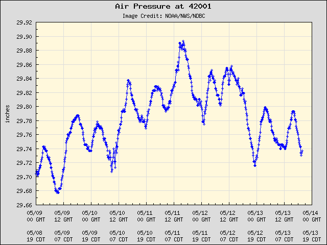
Aric Dunn wrote:Fading convection everywhere except right over the center.. good sign of an organizing TC.
and pressure continues to fall at the buoy right near the convection
https://www.ndbc.noaa.gov/plot_met.php?station=42001&meas=pres&uom=E&time_diff=-5&time_label=CDT
Yeah it needed to rid itself of all the other scattered convection. Centralized convection will help this tighten up quicker. I think most models are sleeping on this one.
3 likes
This post is not an official forecast and should not be used as such. It is just the opinion of MississippiWx and may or may not be backed by sound meteorological data. It is not endorsed by any professional institution including storm2k.org. For Official Information please refer to the NHC and NWS products.
-
HurricaneBrain

- S2K Supporter
- Posts: 520
- Joined: Thu Jun 30, 2011 2:07 pm
Re: ATL: INVEST 91L - Discussion
Recon headed back at 5:45 am EDT. I have my bets on them finding Hanna then.
https://twitter.com/mikeadcockwx/status/1286118131174453249
https://twitter.com/mikeadcockwx/status/1286118131174453249
1 likes
-
HurricaneBrain
- S2K Supporter
- Posts: 520
- Joined: Thu Jun 30, 2011 2:07 pm
Re: ATL: INVEST 91L - Discussion
We have Tropical Depression 8. Skipped the PTC designation. Tropical Storm watch issued for most of Texas coast.
0 likes
-
HurricaneFrances04
- Category 2
- Posts: 597
- Joined: Mon Jun 25, 2012 8:09 am
- Location: Fort Lauderdale, Florida
-
EquusStorm
- Category 5
- Posts: 1649
- Age: 35
- Joined: Thu Nov 07, 2013 1:04 pm
- Location: Jasper, AL
- Contact:
Re: ATL: INVEST 91L - Discussion
TD8. That happened fast
0 likes
Colors of lost purpose on the canvas of irrelevance
Not a meteorologist, in fact more of an idiot than anything. You should probably check with the NHC or a local NWS office for official information.
Not a meteorologist, in fact more of an idiot than anything. You should probably check with the NHC or a local NWS office for official information.
-
Aric Dunn
- Category 5
- Posts: 21238
- Age: 43
- Joined: Sun Sep 19, 2004 9:58 pm
- Location: Ready for the Chase.
- Contact:
Re: ATL: INVEST 91L - Discussion
HurricaneBrain wrote:We have Tropical Depression 8.
Makes sense. the llc was defined enough earlier from recon.. just lacked organized convection.
now we have some better organized convection around the center.
though I wish recon had sampled the full wind field. we would probably already have Hanna
3 likes
Note: If I make a post that is brief. Please refer back to previous posts for the analysis or reasoning. I do not re-write/qoute what my initial post said each time.
If there is nothing before... then just ask
Space & Atmospheric Physicist, Embry-Riddle Aeronautical University,
I believe the sky is falling...
If there is nothing before... then just ask
Space & Atmospheric Physicist, Embry-Riddle Aeronautical University,
I believe the sky is falling...
Who is online
Users browsing this forum: No registered users and 17 guests