
2020 Global Model Runs Discussion (Out thru day 16)
Moderator: S2k Moderators
Forum rules

The posts in this forum are NOT official forecasts and should not be used as such. They are just the opinion of the poster and may or may not be backed by sound meteorological data. They are NOT endorsed by any professional institution or STORM2K. For official information, please refer to products from the National Hurricane Center and National Weather Service.
-
supercane4867
- Category 5

- Posts: 4966
- Joined: Wed Nov 14, 2012 10:43 am
-
TheDreamTraveler

- Category 2

- Posts: 645
- Joined: Sun Aug 22, 2010 3:10 am
- Location: PA
Re: 2020 Global Model Runs Discussion (Out thru day 16)
One thing that caught my attention this year on modeling is tropical storms Bertha and Fay on the east coast. They both made very bizarre and odd tracks climatologically very early in the season. Bertha went northwest into South Carolina and Fay hugged the mid atlantic coast and shot due north into NJ/NY and the northeast. Not only is that rare in general but even rarer in early July and not only happened once but twice. Normally these storms don't make landfall and move northeast away from land. My point is it gives you a potential hint of the overall pattern for this year. We also had other storms already strike the Gulf coast as well. So it doesn't surprise me that we're seeing african waves this early in the season striking the gulf and east coasts already.
Another thing too is we're at record pace for named storms even beating out 2005. The problem with that though is this is still no 2005 because the ACE of 2005 is unparalleled to anything before it including this year despite having more named storms already. The fact we have so many storms forming will increase the chances of potential landfalls too given the pattern is right to steer them close to the US coast. Just felt like sharing these observations lol
Another thing too is we're at record pace for named storms even beating out 2005. The problem with that though is this is still no 2005 because the ACE of 2005 is unparalleled to anything before it including this year despite having more named storms already. The fact we have so many storms forming will increase the chances of potential landfalls too given the pattern is right to steer them close to the US coast. Just felt like sharing these observations lol
5 likes
-
Ivanhater

- Storm2k Moderator

- Posts: 11221
- Age: 39
- Joined: Fri Jul 01, 2005 8:25 am
- Location: Pensacola
Re: 2020 Global Model Runs Discussion (Out thru day 16)
TheProfessor wrote:Ivanhater wrote:I'm not sure exactly what the catalyst is but quite a few models are showing another spin up in the Gulf behind future Hannah, early next week. Icon, Cmc, Ukmethttps://uploads.tapatalk-cdn.com/20200723/96060e947f7a1d59cd492b1535a695b5.jpg https://uploads.tapatalk-cdn.com/20200723/9bba7ead4287e9addff7d8f693d2fd74.jpg https://uploads.tapatalk-cdn.com/20200723/ca14494e8e0874d68801cd68ee2cb3ad.jpg
Sent from my SM-G955U using Tapatalk
Steve has been alluding to this. Meanwhile here's yesterday's 6z Parallel GFS that just came out.
https://i.imgur.com/2VoBpc9.gif
Part of me want to attribute this to convective feedback(especially in the case above) but multiple models falling prey to that would be weird. Definitely something interesting and any leftover energy will need to be watched.
I didn't think to check the parallel. I agree, quite a few models showing this feature in some form in the Gulf in the 3 to 5 day range. Something to keep an eye on...
0 likes
Michael
-
TheProfessor

- Professional-Met

- Posts: 3506
- Age: 29
- Joined: Tue Dec 03, 2013 10:56 am
- Location: Wichita, Kansas
Re: 2020 Global Model Runs Discussion (Out thru day 16)
TheStormExpert wrote:TheProfessor wrote:TheStormExpert wrote:What do you mean?
Ah, it's a show, there is a character that shows up named Josephine, a real lunatic really. I don't want to spoil though.
Which show, never seen it?
The show is called The 100. It's on TheCW. Currently it's in the last season. It's on Netflix and is a pretty good watch, starts off a bit as a teen drama, but really finds its footing in the second season.
1 likes
An alumnus of The Ohio State University.
Your local National Weather Service office is your best source for weather information.
Your local National Weather Service office is your best source for weather information.
-
TheStormExpert
Re: 2020 Global Model Runs Discussion (Out thru day 16)
TheProfessor wrote:TheStormExpert wrote:TheProfessor wrote:
Ah, it's a show, there is a character that shows up named Josephine, a real lunatic really. I don't want to spoil though.
Which show, never seen it?
The show is called The 100. It's on TheCW. Currently it's in the last season. It's on Netflix and is a pretty good watch, starts off a bit as a teen drama, but really finds its footing in the second season.
Oh thanks! I might try watching it if I get some time.
0 likes

Re: 2020 Global Model Runs Discussion (Out thru day 16)
I think we might have to worry about something in the Gulf or western Caribbean in the next 1-2 weeks. The CMC tries to redevelop Gonzalo in the Bay of Campeche, ICON shows Gonzalo surviving into the Caribbean, and both the ICON and ECMWF still show a low-rider developing from that vigorous AEW. It’s possible “future Isaias” could take a track comparable to storms like Emily and Allen, although most of the Euro ensembles pull it north through the Greater Antilles and into the region around the Bahamas.
0 likes
Irene '11 Sandy '12 Hermine '16 5/15/2018 Derecho Fay '20 Isaias '20 Elsa '21 Henri '21 Ida '21
I am only a meteorology enthusiast who knows a decent amount about tropical cyclones. Look to the professional mets, the NHC, or your local weather office for the best information.
I am only a meteorology enthusiast who knows a decent amount about tropical cyclones. Look to the professional mets, the NHC, or your local weather office for the best information.

Re: 2020 Global Model Runs Discussion (Out thru day 16)
aspen wrote:I think we might have to worry about something in the Gulf or western Caribbean in the next 1-2 weeks. The CMC tries to redevelop Gonzalo in the Bay of Campeche, ICON shows Gonzalo surviving into the Caribbean, and both the ICON and ECMWF still show a low-rider developing from that vigorous AEW. It’s possible “future Isaias” could take a track comparable to storms like Emily and Allen, although most of the Euro ensembles pull it north through the Greater Antilles and into the region around the Bahamas.
When storms are emerging off the coast of Africa I’ve noticed many times models want to take them north way too quickly, even many times curving them ots but models adjust back west with time.
2 likes
-
TheProfessor
- Professional-Met
- Posts: 3506
- Age: 29
- Joined: Tue Dec 03, 2013 10:56 am
- Location: Wichita, Kansas
Re: 2020 Global Model Runs Discussion (Out thru day 16)
This feature in the northern Gulf that's been showing up on some of the models needs to be watched. You can see it on the 12z NAM and the 6z HWRF-P. It could steal the I name, but even if it's unnamed, it could cause problems for areas on the northern coast that are already getting rain from Hanna.
2 likes
An alumnus of The Ohio State University.
Your local National Weather Service office is your best source for weather information.
Your local National Weather Service office is your best source for weather information.
Re: 2020 Global Model Runs Discussion (Out thru day 16)
After 92L there doesn’t seem to be much to talk about on the models, but I doubt that holds true as models are really struggling to forecast genesis this year. I see the wave train over Africa is looking pretty good. There’s currently a very strong wave over Nigeria.
0 likes
Re: 2020 Global Model Runs Discussion (Out thru day 16)
Cpv17 wrote:After 92L there doesn’t seem to be much to talk about on the models, but I doubt that holds true as models are really struggling to forecast genesis this year. I see the wave train over Africa is looking pretty good. There’s currently a very strong wave over Nigeria.

GFS Parallel shows this feature at Hour 336...This is a long way of out of course. It appears to ultimately track the feature WSW into Mexico strengthing as it does so. Ironically very similar to the west-southwestly turn of Hanna.
0 likes
-
gatorcane

- S2K Supporter

- Posts: 23708
- Age: 48
- Joined: Sun Mar 13, 2005 3:54 pm
- Location: Boca Raton, FL
Re: 2020 Global Model Runs Discussion (Out thru day 16)
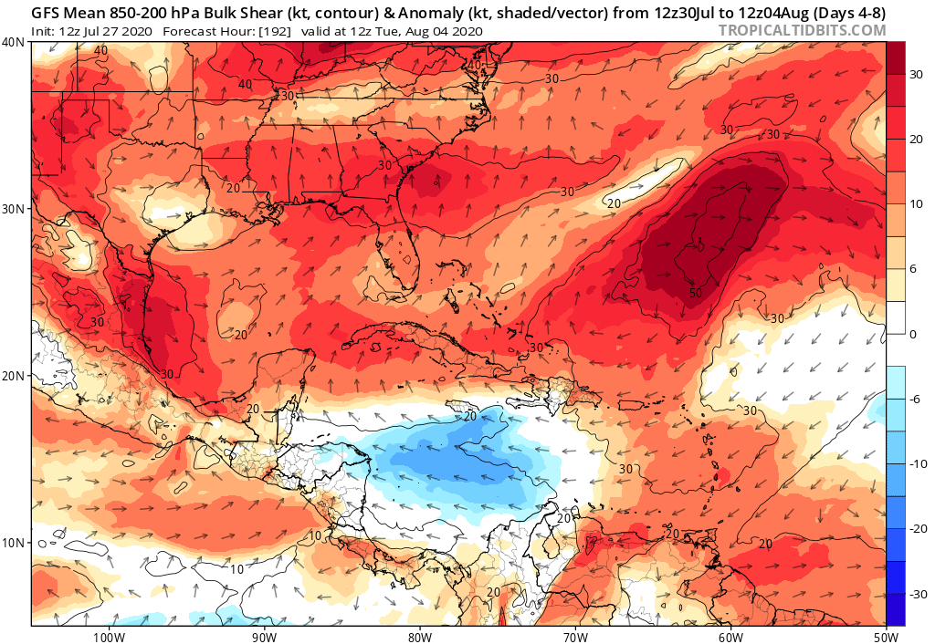
The GFS is showing much higher than normal shear over the entire SW Atlantic, Bahamas, Florida, and Gulf at least through the next week:
0 likes
-
AJC3

- Admin

- Posts: 4155
- Age: 62
- Joined: Tue Aug 31, 2004 7:04 pm
- Location: Ballston Spa, New York
- Contact:
Re: 2020 Global Model Runs Discussion (Out thru day 16)
Polite reminder: If there's an area of disturbed weather you wish to discuss, by all means, feel free to start a thread on it. If you want to talk about seasonal conditions, etc., there's another thread for that. Let's keep this thread on-topic (i.e. about model guidance through day 16). I had to delete a solid page worth of OT posts.
Thanks.
Thanks.
6 likes
Re: 2020 Global Model Runs Discussion (Out thru day 16)
I think we might need to keep an eye on that tropical wave in the central MDR. The GFS, Euro, GFS-Para, and ICON all hint at a weak TC developing from it in a few days. It recurves without hitting the Lesser Antilles or US East Coast, but it might get close to Bermuda.
3 likes
Irene '11 Sandy '12 Hermine '16 5/15/2018 Derecho Fay '20 Isaias '20 Elsa '21 Henri '21 Ida '21
I am only a meteorology enthusiast who knows a decent amount about tropical cyclones. Look to the professional mets, the NHC, or your local weather office for the best information.
I am only a meteorology enthusiast who knows a decent amount about tropical cyclones. Look to the professional mets, the NHC, or your local weather office for the best information.
-
Hurricaneman

- Category 5
- Posts: 7404
- Age: 45
- Joined: Tue Aug 31, 2004 3:24 pm
- Location: central florida
Re: 2020 Global Model Runs Discussion (Out thru day 16)
aspen wrote:I think we might need to keep an eye on that tropical wave in the central MDR. The GFS, Euro, GFS-Para, and ICON all hint at a weak TC developing from it in a few days. It recurves without hitting the Lesser Antilles or US East Coast, but it might get close to Bermuda.
Definitely need to watch that system as the models have been atrocious at picking out development this year and this could be underestimated
5 likes
-
CyclonicFury

- Category 5
- Posts: 2033
- Age: 27
- Joined: Sun Jul 02, 2017 12:32 pm
- Location: NC
- Contact:
Re: 2020 Global Model Runs Discussion (Out thru day 16)
GFS is now developing the wave behind 93L in about 5-6 days.
1 likes
NCSU B.S. in Meteorology Class of 2021. Tropical weather blogger at http://www.cyclonicfury.com. My forecasts and thoughts are NOT official, for official forecasts please consult the National Hurricane Center.

Re: 2020 Global Model Runs Discussion (Out thru day 16)
CyclonicFury wrote:GFS is now developing the wave behind 93L in about 5-6 days.
And the wave party continues

1 likes
-
EquusStorm
- Category 5
- Posts: 1649
- Age: 35
- Joined: Thu Nov 07, 2013 1:04 pm
- Location: Jasper, AL
- Contact:
Re: 2020 Global Model Runs Discussion (Out thru day 16)
GFS also wants the wave between 93L and Isaias to briefly close off NE of the Antilles now in addition to that post-93L wave... whiiich it wants to make a dangerous looking low latitude hurricane into the Caribbean
Not that GFS medium range tropical cyclogenesis has been anywhere close to good lately but still, good lord
Not that GFS medium range tropical cyclogenesis has been anywhere close to good lately but still, good lord
1 likes
Colors of lost purpose on the canvas of irrelevance
Not a meteorologist, in fact more of an idiot than anything. You should probably check with the NHC or a local NWS office for official information.
Not a meteorologist, in fact more of an idiot than anything. You should probably check with the NHC or a local NWS office for official information.
-
cycloneye

- Admin
- Posts: 149438
- Age: 69
- Joined: Thu Oct 10, 2002 10:54 am
- Location: San Juan, Puerto Rico
Re: 2020 Global Model Runs Discussion (Out thru day 16)


4 likes
Visit the Caribbean-Central America Weather Thread where you can find at first post web cams,radars
and observations from Caribbean basin members Click Here
and observations from Caribbean basin members Click Here


-
ouragans

- Category 2
- Posts: 501
- Age: 54
- Joined: Sun Jun 12, 2011 12:09 pm
- Location: Abymes, Guadeloupe F.W.I
- Contact:
Re: 2020 Global Model Runs Discussion (Out thru day 16)
I'm on this one
FYI in Martinique a statue of former French imperor Josephine (Napoleon Bonaparte's spouse) has been brought down by some people last week. She was born in Martinique.
The next name on the list is... Josephine
3 likes
Personal forecast disclaimer
This post is a personal point of view, not an information. Please refer to official statements for life-threatening decisions.
David '79, Frederic '79, Hugo '89, Iris, Luis & Marilyn '95, Georges '98, Lenny '99, Dean '07, Irma '17, Maria '17, Fiona '22, Philippe '23, Tammy '23
16°13'33.3,"6N -61°36'39.5"W
Who is online
Users browsing this forum: No registered users and 309 guests