NEW TROPICAL CYCLONE FORECAST TO DEVELOP AFTER 72 HOURS
FORECAST POSITION AT T+ 72 : 13.0N 44.6W
LEAD CENTRAL MAXIMUM WIND
VERIFYING TIME TIME POSITION PRESSURE (MB) SPEED (KNOTS)
-------------- ---- -------- ------------- -------------
1200UTC 27.07.2020 72 13.0N 44.6W 1008 31
0000UTC 28.07.2020 84 13.4N 48.8W 1007 33
1200UTC 28.07.2020 96 14.0N 53.2W 1006 35
0000UTC 29.07.2020 108 14.7N 56.9W 1004 39
1200UTC 29.07.2020 120 16.3N 60.9W 1001 42
0000UTC 30.07.2020 132 17.3N 64.7W 996 50
1200UTC 30.07.2020 144 17.9N 67.8W 993 51
Strong Tropical Wave SSE of Cabo Verde Islands (Is Invest 92L)
Moderator: S2k Moderators
Forum rules

The posts in this forum are NOT official forecasts and should not be used as such. They are just the opinion of the poster and may or may not be backed by sound meteorological data. They are NOT endorsed by any professional institution or STORM2K. For official information, please refer to products from the National Hurricane Center and National Weather Service.
-
ColdMiser123

- Professional-Met

- Posts: 905
- Age: 29
- Joined: Mon Sep 26, 2016 3:26 pm
- Location: Northeast US
Re: Strong Tropical Wave SSE of Cabo Verde Islands
5 likes
B.S., M.S., Meteorology & Atmospheric Science
-
AutoPenalti
- Category 5

- Posts: 4091
- Age: 29
- Joined: Mon Aug 17, 2015 4:16 pm
- Location: Ft. Lauderdale, Florida
Re: Strong Tropical Wave SSE of Cabo Verde Islands
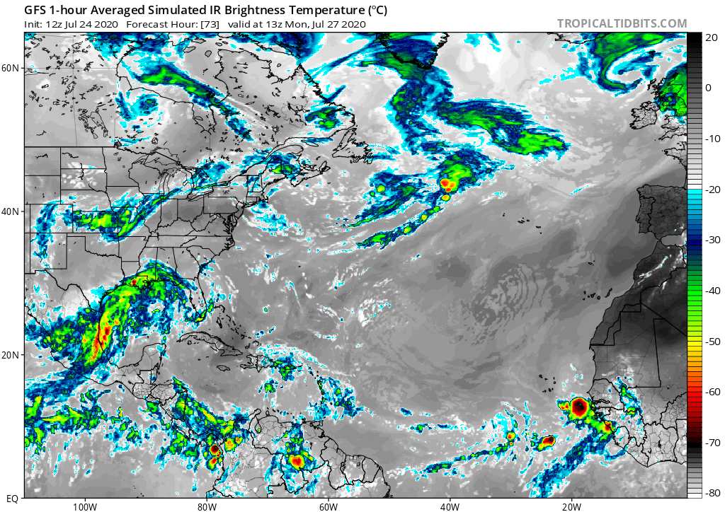
gatorcane wrote:The GFS doesn’t have much left of this in a few days as you can see by the simulated IR with a few pops SW of the Cape Verde islands. The real question is once it gets to the Western Atlantic later next week into next weekend, will this wave find some favorable conditions? The GFS says there won’t be enough left of this wave while the Euro insists it will develop.
Notice also from sat imagery how this wave is heavily embedded in the SAL. I expect convection to be on the downward trend the next few days:
https://www.tropicaltidbits.com/sat/sat ... =truecolor
https://i.postimg.cc/j5mpfcFd/gfs-ir-atl-13.png
I 100% do not buy this run, especially in favorable conditions.
1 likes
The posts in this forum are NOT official forecasts and should not be used as such. They are just the opinion of the poster and may or may not be backed by sound meteorological data. They are NOT endorsed by any professional institution or STORM2K. For official information, please refer to products from the NHC and NWS.
Model Runs Cheat Sheet:
GFS (5:30 AM/PM, 11:30 AM/PM)
HWRF, GFDL, UKMET, NAVGEM (6:30-8:00 AM/PM, 12:30-2:00 AM/PM)
ECMWF (1:45 AM/PM)
TCVN is a weighted averaged

Re: Strong Tropical Wave SSE of Cabo Verde Islands
AutoPenalti wrote:gatorcane wrote:The GFS doesn’t have much left of this in a few days as you can see by the simulated IR with a few pops SW of the Cape Verde islands. The real question is once it gets to the Western Atlantic later next week into next weekend, will this wave find some favorable conditions? The GFS says there won’t be enough left of this wave while the Euro insists it will develop.
Notice also from sat imagery how this wave is heavily embedded in the SAL. I expect convection to be on the downward trend the next few days:
https://www.tropicaltidbits.com/sat/sat ... =truecolor
https://i.postimg.cc/j5mpfcFd/gfs-ir-atl-13.png
I 100% do not buy this run, especially in favorable conditions.
SAl is still definitely a player for a little while longer, it's not mid-August yet. That has to be considered. If it were mid-August and beyond, I'd be 100% with you.
0 likes
Personal Forecast Disclaimer:
The posts in this forum are NOT official forecast and should not be used as such. They are just the opinion of the poster and may or may not be backed by sound meteorological data. They are NOT endorsed by any professional institution or storm2k.org. For official information, please refer to the NHC and NWS products.
The posts in this forum are NOT official forecast and should not be used as such. They are just the opinion of the poster and may or may not be backed by sound meteorological data. They are NOT endorsed by any professional institution or storm2k.org. For official information, please refer to the NHC and NWS products.
-
TheStormExpert
Re: Strong Tropical Wave SSE of Cabo Verde Islands
Cpv17 wrote:TheStormExpert wrote:SFLcane wrote:
Hey Jeremy!
Glad to see on here again. Yep this is one to watch much better moist environment surrounded it.It’s going to head west for a while.
This one is definitely going to have a much more favorable environment as a favorable Kelvin Wave passes. The GFS is lost in my opinion.
The GFS has been lost for a while now. It can’t even see genesis till it’s already happening.
Yep, probably won’t develop this or at least show anything until after the fact that it’s developed.
0 likes
-
DorkyMcDorkface

- Category 4

- Posts: 988
- Age: 28
- Joined: Mon Sep 30, 2019 1:32 pm
- Location: Mid-Atlantic
Re: Strong Tropical Wave SSE of Cabo Verde Islands
gatorcane wrote:The GFS doesn’t have much left of this in a few days as you can see by the simulated IR with a few pops SW of the Cape Verde islands. The real question is once it gets to the Western Atlantic later next week into next weekend, will this wave find some favorable conditions? The GFS says there won’t be enough left of this wave while the Euro insists it will develop.
Notice also from sat imagery how this wave is heavily embedded in the SAL. I expect convection to be on the downward trend the next few days:
https://www.tropicaltidbits.com/sat/sat ... =truecolor
https://i.postimg.cc/j5mpfcFd/gfs-ir-atl-13.png
My confidence in the GFS as of late has been running very low. It had to play catch-up with not just Gonzalo and Hanna, but Douglas as well. For the latter, it literally had it as an open wave several hundred miles SW of the Hawaiian islands for a few runs, yet we ended up getting a category 4. I don't know if it's a consequence of lack of proper observational aircraft data due to the pandemic or what, but it has really been off recently, so I am not sure what to think about it right now.
0 likes
Please note the thougths expressed by this account are solely those of the user and are from a hobbyist perspective. For more comprehensive analysis, consult an actual professional meteorologist or meteorology agency.
Floyd 1999 | Isabel 2003 | Hanna 2008 | Irene 2011 | Sandy 2012 | Isaias 2020

-
cycloneye

- Admin

- Posts: 149278
- Age: 69
- Joined: Thu Oct 10, 2002 10:54 am
- Location: San Juan, Puerto Rico
Re: Strong Tropical Wave SSE of Cabo Verde Islands
ColdMiser123 wrote:NEW TROPICAL CYCLONE FORECAST TO DEVELOP AFTER 72 HOURS
FORECAST POSITION AT T+ 72 : 13.0N 44.6W
LEAD CENTRAL MAXIMUM WIND
VERIFYING TIME TIME POSITION PRESSURE (MB) SPEED (KNOTS)
-------------- ---- -------- ------------- -------------
1200UTC 27.07.2020 72 13.0N 44.6W 1008 31
0000UTC 28.07.2020 84 13.4N 48.8W 1007 33
1200UTC 28.07.2020 96 14.0N 53.2W 1006 35
0000UTC 29.07.2020 108 14.7N 56.9W 1004 39
1200UTC 29.07.2020 120 16.3N 60.9W 1001 42
0000UTC 30.07.2020 132 17.3N 64.7W 996 50
1200UTC 30.07.2020 144 17.9N 67.8W 993 51
UKMET is on board much more now.
0 likes
Visit the Caribbean-Central America Weather Thread where you can find at first post web cams,radars
and observations from Caribbean basin members Click Here
and observations from Caribbean basin members Click Here
-
TheStormExpert
Re: Strong Tropical Wave SSE of Cabo Verde Islands
Still awaiting this afternoon’s 12z Euro run.
https://twitter.com/dylanfedericowx/status/1286697547764039680
https://twitter.com/dylanfedericowx/status/1286697547764039680
0 likes

Re: Strong Tropical Wave SSE of Cabo Verde Islands
What would be the outcome if you follow this out?
0 likes
Re: Strong Tropical Wave SSE of Cabo Verde Islands
abk_0710 wrote:
What would be the outcome if you follow this out?
A lot of bad stuff for the islands. It rolls right over them.
0 likes
Personal Forecast Disclaimer:
The posts in this forum are NOT official forecast and should not be used as such. They are just the opinion of the poster and may or may not be backed by sound meteorological data. They are NOT endorsed by any professional institution or storm2k.org. For official information, please refer to the NHC and NWS products.
The posts in this forum are NOT official forecast and should not be used as such. They are just the opinion of the poster and may or may not be backed by sound meteorological data. They are NOT endorsed by any professional institution or storm2k.org. For official information, please refer to the NHC and NWS products.
Re: Strong Tropical Wave SSE of Cabo Verde Islands
The classic September CV long range track we are accustomed to. Except a month behind
0 likes
-
TheStormExpert
Re: Strong Tropical Wave SSE of Cabo Verde Islands
How can we trust this model when it doesn’t even pick up on Gonzalo? After it’s screwup with Dorian it’s lost my trust.
0 likes
-
cycloneye
- Admin
- Posts: 149278
- Age: 69
- Joined: Thu Oct 10, 2002 10:54 am
- Location: San Juan, Puerto Rico
Re: Strong Tropical Wave SSE of Cabo Verde Islands
Graphic of UKMET. 

0 likes
Visit the Caribbean-Central America Weather Thread where you can find at first post web cams,radars
and observations from Caribbean basin members Click Here
and observations from Caribbean basin members Click Here
Re: Strong Tropical Wave SSE of Cabo Verde Islands
So someone mentioned that some of the models use commercial airline data for model runs. Do we have a list of the ones that use it, how much, etc?
3 likes
Personal Forecast Disclaimer:
The posts in this forum are NOT official forecast and should not be used as such. They are just the opinion of the poster and may or may not be backed by sound meteorological data. They are NOT endorsed by any professional institution or storm2k.org. For official information, please refer to the NHC and NWS products.
The posts in this forum are NOT official forecast and should not be used as such. They are just the opinion of the poster and may or may not be backed by sound meteorological data. They are NOT endorsed by any professional institution or storm2k.org. For official information, please refer to the NHC and NWS products.
-
toad strangler

- S2K Supporter

- Posts: 4546
- Joined: Sun Jul 28, 2013 3:09 pm
- Location: Earth
- Contact:
Re: Strong Tropical Wave SSE of Cabo Verde Islands
TheStormExpert wrote:
How can we trust this model when it doesn’t even pick up on Gonzalo? After it’s screwup with Dorian it’s lost my trust.
You don't TRUST models.. You USE models. They are tools ... some have different bias and weakness then others.
11 likes
My Weather Station
https://www.wunderground.com/dashboard/pws/KFLPORTS603
https://www.wunderground.com/dashboard/pws/KFLPORTS603
-
SFLcane

- S2K Supporter
- Posts: 10281
- Age: 48
- Joined: Sat Jun 05, 2010 1:44 pm
- Location: Lake Worth Florida
Re: Strong Tropical Wave SSE of Cabo Verde Islands
Up to 40%...
A tropical wave located about 300 miles south-southeast of the Cabo Verde Islands continues to produced an area of cloudiness and disorganized showers and thunderstorms. The disturbance is expected move westward across the tropical Atlantic during the next several days, and some gradual development of this system is possible by
early next week when it reaches the western tropical Atlantic.
* Formation chance through 48 hours...low...near 0 percent.
* Formation chance through 5 days...medium...40 percent.
3 likes
-
cycloneye
- Admin
- Posts: 149278
- Age: 69
- Joined: Thu Oct 10, 2002 10:54 am
- Location: San Juan, Puerto Rico
Re: Strong Tropical Wave SSE of Cabo Verde Islands
SFLcane wrote:Up to 40%...
A tropical wave located about 300 miles south-southeast of the Cabo Verde Islands continues to produced an area of cloudiness and disorganized showers and thunderstorms. The disturbance is expected move westward across the tropical Atlantic during the next several days, and some gradual development of this system is possible by
early next week when it reaches the western tropical Atlantic.
* Formation chance through 48 hours...low...near 0 percent.
* Formation chance through 5 days...medium...40 percent.

1 likes
Visit the Caribbean-Central America Weather Thread where you can find at first post web cams,radars
and observations from Caribbean basin members Click Here
and observations from Caribbean basin members Click Here
-
cheezyWXguy

- Category 5
- Posts: 6281
- Joined: Mon Feb 13, 2006 12:29 am
- Location: Dallas, TX
Re: Strong Tropical Wave SSE of Cabo Verde Islands
toad strangler wrote:TheStormExpert wrote:
How can we trust this model when it doesn’t even pick up on Gonzalo? After it’s screwup with Dorian it’s lost my trust.
You don't TRUST models.. You USE models. They are tools ... some have different bias and weakness then others.
This hits the nail on the head. It’s also important to understand just how complex the atmosphere is in contrast to how it’s resolved on models. Dorian went through a reasonably complex evolution as its center relocated prior to the islands, which caused significant downstream impacts to track and intensity. And all things considered, Gonzalo is basically a blip on the radar, given its small size and short-lived intensity. Even the NHC couldn’t keep up with its fluctuations.
1 likes
-
TheStormExpert
Re: Strong Tropical Wave SSE of Cabo Verde Islands
toad strangler wrote:TheStormExpert wrote:
How can we trust this model when it doesn’t even pick up on Gonzalo? After it’s screwup with Dorian it’s lost my trust.
You don't TRUST models.. You USE models. They are tools ... some have different bias and weakness then others.
Well we can’t use a model that has bad input! That’s why I don’t consider it a top-tier global model.
0 likes


Re: Strong Tropical Wave SSE of Cabo Verde Islands
ECMWF 120hrs out.. looks a touch slower than 0z
0 likes
Who is online
Users browsing this forum: Patrick99, pepecool20 and 212 guests