ATL: HANNA - Remnants - Discussion

Moderator: S2k Moderators

Message
Author
TheStormExpert

Re: ATL: HANNA - Tropical Storm - Discussion

#961 Postby TheStormExpert » Fri Jul 24, 2020 12:35 pm

wxman57 wrote:
NDG wrote:89 meters seem to be way too high to put anemometer on a ship.


Anemometers are placed above anything that might obstruct the wind, and that's always at the highest point. Otherwise, the wind would be blocked from some directions. On the offshore platforms, that's usually at the top of the derrick. That's why they record much higher winds than 10m above the water.

By the way, I've been in contact with Josh Morgerman. He's left his Mississippi summer rental home and is on his way to intercept Hanna.

Yep!

 https://twitter.com/icyclone/status/1286716058863362050


0 likes   

wx98
Category 5
Category 5
Posts: 1383
Joined: Sat Aug 25, 2018 9:24 pm

Re: ATL: HANNA - Tropical Storm - Discussion

#962 Postby wx98 » Fri Jul 24, 2020 12:36 pm

eastcoastFL wrote:
HurricaneAndre2008 wrote:Current Intensity Analysis


UW - CIMSS
ADVANCED DVORAK TECHNIQUE
ADT-Version 9.0
Tropical Cyclone Intensity Algorithm

----- Current Analysis -----
Date : 24 JUL 2020 Time : 152024 UTC
Lat : 27:12:46 N Lon : 93:14:57 W


CI# /Pressure/ Vmax
3.2 / 991.7mb/ 49.0kt


991mb?! Is that at the surface?


That’s just an estimate. Not actually measured. Although if recon was still in there I’d suspect they’d find sub-1000 for sure.
2 likes   

User avatar
eastcoastFL
Category 5
Category 5
Posts: 3900
Age: 43
Joined: Thu Apr 12, 2007 12:29 pm
Location: Palm City, FL

Re: ATL: HANNA - Tropical Storm - Discussion

#963 Postby eastcoastFL » Fri Jul 24, 2020 12:37 pm

Looking pretty impressive on visible right now. Can definitely see where it’s trying to clear out some kind of an eye. Pretty decent outflow.

Question : With some bigger storms we see the outflow flatten as it bumps up against the ridge and the ridge pushes down on it. Am I not seeing that now because the storm isn’t as organized yet or is the ridge weaker? Or is it just not pushing up against the ridge yet? I can’t remember if that just happens when it bumps up against the ridge and starts it’s turn. Thanks


Image
0 likes   

User avatar
eastcoastFL
Category 5
Category 5
Posts: 3900
Age: 43
Joined: Thu Apr 12, 2007 12:29 pm
Location: Palm City, FL

Re: ATL: HANNA - Tropical Storm - Discussion

#964 Postby eastcoastFL » Fri Jul 24, 2020 12:39 pm

jaguars_22 wrote:Would anyone throw in the possibility of the storm doing a loop and staying off coast lol who knows with her and you know ladies :) jk


I think there was a rule against saying stuff like that a few years ago.

As to the question, it doesn’t have enough time to avoid landfall with its current trajectory IMO.
0 likes   
Personal Forecast Disclaimer:
The posts in this forum are NOT official forecast and should not be used as such. They are just the opinion of the poster and may or may not be backed by sound meteorological data. They are NOT endorsed by any professional institution or storm2k.org. For official information, please refer to the NHC and NWS products.

User avatar
eastcoastFL
Category 5
Category 5
Posts: 3900
Age: 43
Joined: Thu Apr 12, 2007 12:29 pm
Location: Palm City, FL

Re: ATL: HANNA - Tropical Storm - Discussion

#965 Postby eastcoastFL » Fri Jul 24, 2020 12:41 pm

wx98 wrote:
eastcoastFL wrote:
HurricaneAndre2008 wrote:Current Intensity Analysis


UW - CIMSS
ADVANCED DVORAK TECHNIQUE
ADT-Version 9.0
Tropical Cyclone Intensity Algorithm

----- Current Analysis -----
Date : 24 JUL 2020 Time : 152024 UTC
Lat : 27:12:46 N Lon : 93:14:57 W


CI# /Pressure/ Vmax
3.2 / 991.7mb/ 49.0kt


991mb?! Is that at the surface?


That’s just an estimate. Not actually measured. Although if recon was still in there I’d suspect they’d find sub-1000 for sure.


Thanks. I think The most recent message I saw from recon was right at 1000 mb and they hadn’t crossed into the stronger quadrant yet so I’d definitely agree.
2 likes   
Personal Forecast Disclaimer:
The posts in this forum are NOT official forecast and should not be used as such. They are just the opinion of the poster and may or may not be backed by sound meteorological data. They are NOT endorsed by any professional institution or storm2k.org. For official information, please refer to the NHC and NWS products.

User avatar
HurricaneAndre2008
Category 1
Category 1
Posts: 327
Age: 27
Joined: Wed Jul 31, 2019 9:51 pm
Contact:

Re: ATL: HANNA - Tropical Storm - Discussion

#966 Postby HurricaneAndre2008 » Fri Jul 24, 2020 12:42 pm

ZCZC MIATCPAT3 ALL
TTAA00 KNHC DDHHMM

BULLETIN
Tropical Storm Hanna Intermediate Advisory Number 7A
NWS National Hurricane Center Miami FL AL082020
100 PM CDT Fri Jul 24 2020

...HANNA CONTINUES TO STRENGTHEN OVER THE WESTERN GULF OF MEXICO...


SUMMARY OF 100 PM CDT...1800 UTC...INFORMATION
----------------------------------------------
LOCATION...27.3N 93.7W
ABOUT 230 MI...375 KM E OF CORPUS CHRISTI TEXAS
ABOUT 230 MI...375 KM E OF PORT MANSFIELD TEXAS
MAXIMUM SUSTAINED WINDS...50 MPH...85 KM/H
PRESENT MOVEMENT...WNW OR 285 DEGREES AT 9 MPH...15 KM/H
MINIMUM CENTRAL PRESSURE...999 MB...29.50 INCHES
1 likes   
Cindy(2005), Katrina(2005), Rita(2005), Erin(2007), Isaac(2012)

User avatar
eastcoastFL
Category 5
Category 5
Posts: 3900
Age: 43
Joined: Thu Apr 12, 2007 12:29 pm
Location: Palm City, FL

Re: ATL: HANNA - Tropical Storm - Discussion

#967 Postby eastcoastFL » Fri Jul 24, 2020 12:43 pm

Ivanhater wrote:Almost all models deepen this pretty substantial right before landfall. A hurricane is definitely in play imo


Is there any reason that she could slow down on approach? I know we’ve seen it a dozen times where they kind of slow up as it starts to interact with land. At least it appears to slow or contract due to land interaction.
0 likes   
Personal Forecast Disclaimer:
The posts in this forum are NOT official forecast and should not be used as such. They are just the opinion of the poster and may or may not be backed by sound meteorological data. They are NOT endorsed by any professional institution or storm2k.org. For official information, please refer to the NHC and NWS products.

User avatar
eastcoastFL
Category 5
Category 5
Posts: 3900
Age: 43
Joined: Thu Apr 12, 2007 12:29 pm
Location: Palm City, FL

Re: ATL: HANNA - Tropical Storm - Discussion

#968 Postby eastcoastFL » Fri Jul 24, 2020 12:48 pm

Some nice cold cloud tops firing up right now. She’s looking more and more impressive both visually and structurally.


Image
0 likes   
Personal Forecast Disclaimer:
The posts in this forum are NOT official forecast and should not be used as such. They are just the opinion of the poster and may or may not be backed by sound meteorological data. They are NOT endorsed by any professional institution or storm2k.org. For official information, please refer to the NHC and NWS products.

User avatar
wxman57
Moderator-Pro Met
Moderator-Pro Met
Posts: 22953
Age: 67
Joined: Sat Jun 21, 2003 8:06 pm
Location: Houston, TX (southwest)

Re: ATL: HANNA - Tropical Storm - Discussion

#969 Postby wxman57 » Fri Jul 24, 2020 12:58 pm

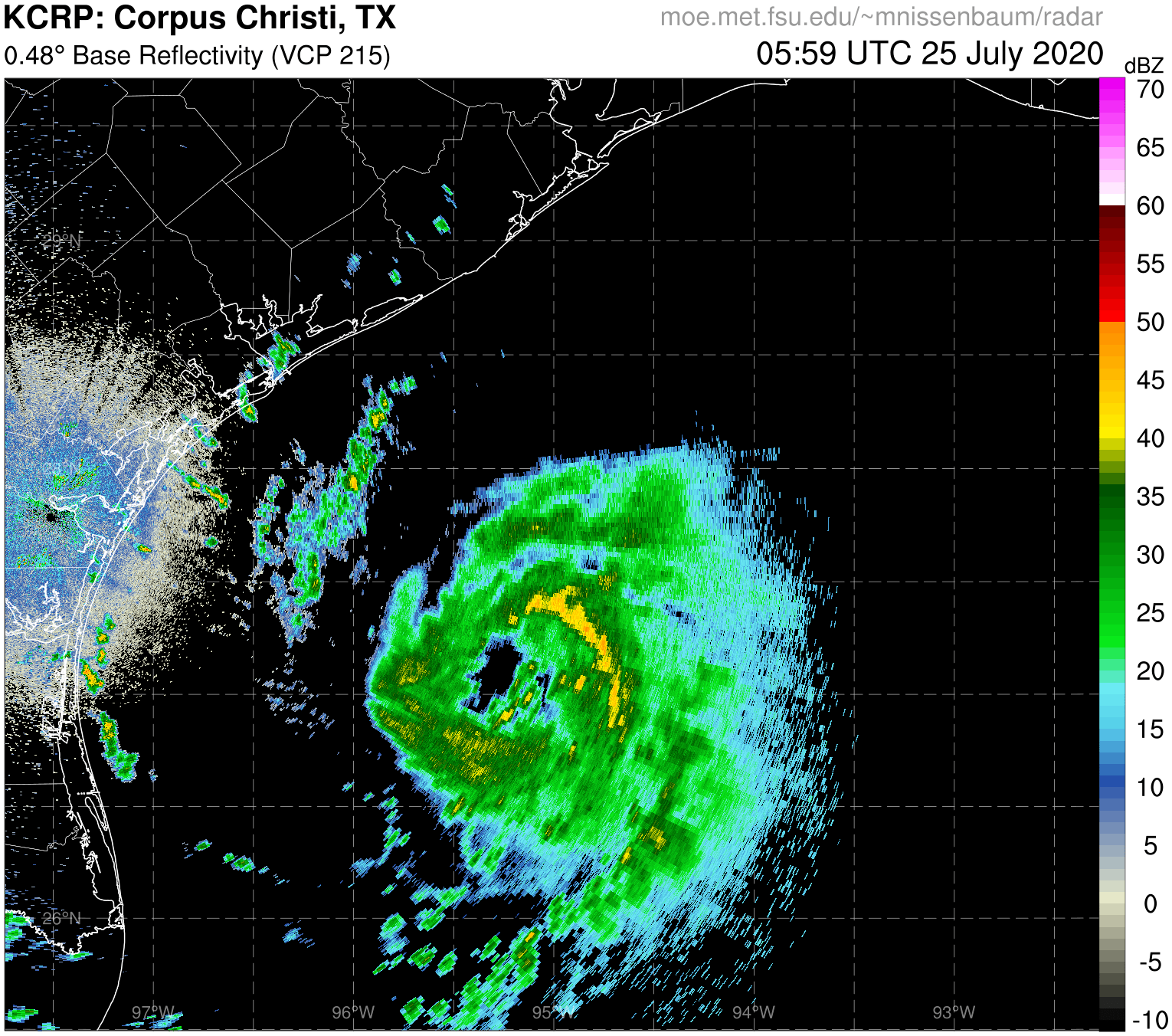
Observation very near the center up to 30 kts. One 35kt observation about 90 miles to the east, but I suspect it is well above 10m in height. There could be a small area of 45-50 mph winds southeast of the center, but squalls around the center are not very strong. We still have 60kts at landfall around 2pm tomorrow. Can't rule out stronger, but not forecasting it yet.

Image
5 likes   

Aric Dunn
Category 5
Category 5
Posts: 21238
Age: 42
Joined: Sun Sep 19, 2004 9:58 pm
Location: Ready for the Chase.
Contact:

Re: ATL: HANNA - Tropical Storm - Discussion

#970 Postby Aric Dunn » Fri Jul 24, 2020 12:59 pm

one good tower on the SW side is all it would need to starting ramping up.
2 likes   
Note: If I make a post that is brief. Please refer back to previous posts for the analysis or reasoning. I do not re-write/qoute what my initial post said each time.
If there is nothing before... then just ask :)

Space & Atmospheric Physicist, Embry-Riddle Aeronautical University,
I believe the sky is falling...

User avatar
GCANE
S2K Supporter
S2K Supporter
Posts: 11453
Joined: Mon Oct 22, 2007 8:03 am

Re: ATL: HANNA - Tropical Storm - Discussion

#971 Postby GCANE » Fri Jul 24, 2020 1:03 pm

Core is restructuring to a more normal altitude.
It was unusually high this morning and IMHO made it spatially unstable.
CAPE just offshore is ramping up and currently at 4500.
That is where the closest feeder is coming from.
Hanna will track into this.


Image

Image
2 likes   

User avatar
Nimbus
Category 5
Category 5
Posts: 5274
Joined: Mon Jul 19, 2004 10:54 am

Re: ATL: HANNA - Tropical Storm - Discussion

#972 Postby Nimbus » Fri Jul 24, 2020 1:04 pm

000
WTNT33 KNHC 241742
TCPAT3

BULLETIN
Tropical Storm Hanna Intermediate Advisory Number 7A
NWS National Hurricane Center Miami FL AL082020
100 PM CDT Fri Jul 24 2020

...HANNA CONTINUES TO STRENGTHEN OVER THE WESTERN GULF OF MEXICO...


SUMMARY OF 100 PM CDT...1800 UTC...INFORMATION
----------------------------------------------
LOCATION...27.3N 93.7W
ABOUT 230 MI...375 KM E OF CORPUS CHRISTI TEXAS
ABOUT 230 MI...375 KM E OF PORT MANSFIELD TEXAS
MAXIMUM SUSTAINED WINDS...50 MPH...85 KM/H
PRESENT MOVEMENT...WNW OR 285 DEGREES AT 9 MPH...15 KM/H
MINIMUM CENTRAL PRESSURE...999 MB...29.50 INCHES


WATCHES AND WARNINGS
--------------------
CHANGES WITH THIS ADVISORY:

None.

SUMMARY OF WATCHES AND WARNINGS IN EFFECT:

A Tropical Storm Warning is in effect for...
* Mouth of the Rio Grande to San Luis Pass Texas

A Tropical Storm Warning means that tropical storm conditions are
expected somewhere within the warning area, in this case within 24
to 36 hours.

Interests along the Texas and Louisiana coast should monitor the
progress of this system.

For storm information specific to your area, including possible
inland watches and warnings, please monitor products issued by your
local National Weather Service forecast office.


DISCUSSION AND OUTLOOK
----------------------
At 100 PM CDT (1800 UTC), the center of Tropical Storm Hanna was
located by satellite and NOAA Doppler weather radars near latitude
27.3 North, longitude 93.7 West. Hanna is moving toward the
west-northwest near 9 mph (15 km/h), and this motion should continue
this afternoon. A turn toward the west is expected tonight,
followed by a westward to west-southwestward motion through the
weekend. On the forecast track, center of Hanna should make
landfall along the Texas coast within the warning area Saturday
afternoon or evening.

Maximum sustained winds have increased to near 50 mph (85 km/h)
with higher gusts. Additional strengthening is expected until the
tropical cyclone makes landfall. Steady weakening is expected after
Hanna moves inland.

Tropical-storm-force winds extend outward up to 60 miles (95 km)
from the center. During the past couple of hours, a ship located
just east of the center reported a sustained wind of 46 mph (74
km/h).

The estimated minimum central pressure is 999 mb (29.50 inches).


HAZARDS AFFECTING LAND
----------------------
Key messages for Tropical Storm Hanna can be found in the
Tropical Cyclone Discussion under AWIPS header MIATCDAT3 and WMO
header WTNT43 KNHC.

WIND: Tropical storm conditions are expected in the warning area
by tonight or Saturday morning.

RAINFALL: Hanna is expected to produce 4 to 8 inches of rain with
isolated maximum totals of 12 inches through Sunday night in south
Texas. This rain may result in life-threatening flash flooding,
rapid rises on small streams, and isolated minor to moderate river
flooding in south Texas.

3 to 5 inches of rain is expected along the upper Texas and
Louisiana coasts, and inland to the Mexican states of Coahuila,
Nuevo Leon, and northern Tamaulipas.

STORM SURGE: The combination of storm surge and the tide will cause
normally dry areas near the coast to be flooded by rising waters
moving inland from the shoreline. The water could reach the
following heights above ground somewhere in the indicated areas if
the peak surge occurs at the time of high tide...

Mouth of the Rio Grande to High Island including Corpus Christi Bay,
Matagorda Bay, and Galveston Bay...1-3 ft

The deepest water will occur along the immediate coast near and to
the right of the landfall location. Surge-related flooding depends
on the relative timing of the surge and the tidal cycle, and can
vary greatly over short distances. For information specific to
your area, please see products issued by your local National
Weather Service forecast office.

SURF: Swells generated by Hanna are expected to increase and affect
much of the Texas and Louisiana coasts during the next few days.
These swells are likely to cause life-threatening surf and rip
current conditions. Please consult products from your local weather
office.


NEXT ADVISORY
-------------
Next complete advisory at 400 PM CDT.

$$
Forecaster Stewart
2 likes   

User avatar
GCANE
S2K Supporter
S2K Supporter
Posts: 11453
Joined: Mon Oct 22, 2007 8:03 am

Re: ATL: HANNA - Tropical Storm - Discussion

#973 Postby GCANE » Fri Jul 24, 2020 1:13 pm

Winding up - highest helicity I have seen so far.

Image
1 likes   

User avatar
TeamPlayersBlue
Category 5
Category 5
Posts: 3444
Joined: Tue Feb 02, 2010 1:44 am
Location: Denver/Applewood, CO

Re: ATL: HANNA - Tropical Storm - Discussion

#974 Postby TeamPlayersBlue » Fri Jul 24, 2020 1:14 pm

Radarscope app i see over 60 mph winds. Its very far out, so thats likely at a high altitude, but interesting to note.
0 likes   
Personal Forecast Disclaimer:
The posts in this forum are NOT official forecast and should not be used as such. They are just the opinion of the poster and may or may not be backed by sound meteorological data. They are NOT endorsed by any professional institution or storm2k.org. For official information, please refer to the NHC and NWS products.

Aric Dunn
Category 5
Category 5
Posts: 21238
Age: 42
Joined: Sun Sep 19, 2004 9:58 pm
Location: Ready for the Chase.
Contact:

Re: ATL: HANNA - Tropical Storm - Discussion

#975 Postby Aric Dunn » Fri Jul 24, 2020 1:15 pm

Couple of possible towers might be starting to fire off in the SW quad for the first time..

that will effectively close off the low to mid level eyewall and deepening can begin.

Image
3 likes   
Note: If I make a post that is brief. Please refer back to previous posts for the analysis or reasoning. I do not re-write/qoute what my initial post said each time.
If there is nothing before... then just ask :)

Space & Atmospheric Physicist, Embry-Riddle Aeronautical University,
I believe the sky is falling...

User avatar
Texashawk
Category 2
Category 2
Posts: 579
Joined: Tue Aug 14, 2007 1:50 am
Location: Missouri City, TX (Houston)

Re: ATL: HANNA - Tropical Storm - Discussion

#976 Postby Texashawk » Fri Jul 24, 2020 1:15 pm

It seems like several of the latest models have landfall closer to Port Aransas/ the Matagorda Bay Area. Is that accurate?
2 likes   

User avatar
HurricaneAndre2008
Category 1
Category 1
Posts: 327
Age: 27
Joined: Wed Jul 31, 2019 9:51 pm
Contact:

Re: ATL: HANNA - Tropical Storm - Discussion

#977 Postby HurricaneAndre2008 » Fri Jul 24, 2020 1:17 pm

TXNT27 KNES 241746
TCSNTL

A. 08L (HANNA)

B. 24/1731Z

C. 27.4N

D. 93.8W

E. THREE/GOES-E

F. T3.5/3.5

G. IR/EIR/VIS

H. REMARKS...6/10 BROKEN WHITE BANDING WAS MEASURED AROUND THE LLCC,
RESULTING IN A DT OF 3.5. THE MET AND PT AGREE AND THE FT IS BASED ON MET,
DUE TO UNCERTAINTY WITH THE EXACT LOCATION OF THE LLCC.

I. ADDL POSITIONS

NIL


...MLEVINE
0 likes   
Cindy(2005), Katrina(2005), Rita(2005), Erin(2007), Isaac(2012)

jaguars_22
Category 2
Category 2
Posts: 571
Joined: Tue Jun 20, 2017 2:26 pm

Re: ATL: HANNA - Tropical Storm - Discussion

#978 Postby jaguars_22 » Fri Jul 24, 2020 1:22 pm

Latest RGEM showing port a then drifting or stationary
3 likes   

User avatar
wxman57
Moderator-Pro Met
Moderator-Pro Met
Posts: 22953
Age: 67
Joined: Sat Jun 21, 2003 8:06 pm
Location: Houston, TX (southwest)

Re: ATL: HANNA - Tropical Storm - Discussion

#979 Postby wxman57 » Fri Jul 24, 2020 1:28 pm

Texashawk wrote:It seems like several of the latest models have landfall closer to Port Aransas/ the Matagorda Bay Area. Is that accurate?


I don't know what models you're looking at, but nothing I see says anywhere near Matagorda. Model trend has been farther south, not farther north.
1 likes   

User avatar
ScottNAtlanta
Category 5
Category 5
Posts: 2360
Joined: Sat May 25, 2013 3:11 pm
Location: Atlanta, GA

Re: ATL: HANNA - Tropical Storm - Discussion

#980 Postby ScottNAtlanta » Fri Jul 24, 2020 1:34 pm

eastcoastFL wrote:Looking pretty impressive on visible right now. Can definitely see where it’s trying to clear out some kind of an eye. Pretty decent outflow.

Question : With some bigger storms we see the outflow flatten as it bumps up against the ridge and the ridge pushes down on it. Am I not seeing that now because the storm isn’t as organized yet or is the ridge weaker? Or is it just not pushing up against the ridge yet? I can’t remember if that just happens when it bumps up against the ridge and starts it’s turn. Thanks


https://www.tropicaltidbits.com/sat/images/goes16_vis_08L_202007241722_lat27.1-lon267.2.jpg


If you want a better way to see that, the WV loop is your best bet, and looking at that, you can see where it is starting to be impacted

https://www.tropicaltidbits.com/sat/sat ... uct=wv-mid
0 likes   
The posts in this forum are NOT official forecast and should not be used as such. They are just the opinion of the poster and may or may not be backed by sound meteorological data. They are NOT endorsed by any professional institution or storm2k.org. For official information, please refer to the NHC and NWS products.


Return to “2020”

Who is online

Users browsing this forum: No registered users and 36 guests