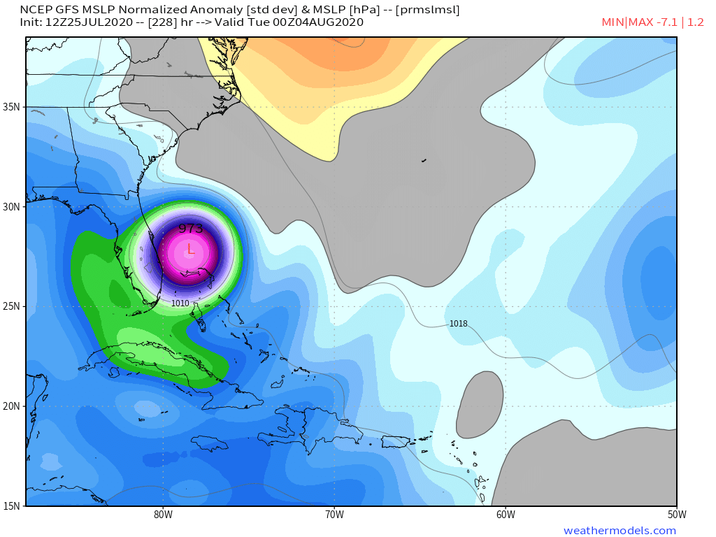
Landfall on the First Coast per GFS. At least it's still one week out and many things can change but the pattern that seems to be trending is for a hurricane threat somewhere from the Carolinas south starting next weekend. This is a good time to check our supplies
The posts in this forum are NOT official forecast and should not be used as such. They are just the opinion of the poster and may or may not be backed by sound meteorological data. They are NOT endorsed by any professional institution or STORM2K. For official information, please refer to products from the NHC and NWS.
ATL: ISAIAS - Models
Moderator: S2k Moderators
Re: ATL: INVEST 92L - Models
Last edited by caneseddy on Sat Jul 25, 2020 11:38 am, edited 2 times in total.
0 likes
-
AutoPenalti
- Category 5

- Posts: 4091
- Age: 29
- Joined: Mon Aug 17, 2015 4:16 pm
- Location: Ft. Lauderdale, Florida
Re: ATL: INVEST 92L - Models
So there’s just a random shortwave chillin’ by the Tennessee Valley?
0 likes
The posts in this forum are NOT official forecasts and should not be used as such. They are just the opinion of the poster and may or may not be backed by sound meteorological data. They are NOT endorsed by any professional institution or STORM2K. For official information, please refer to products from the NHC and NWS.
Model Runs Cheat Sheet:
GFS (5:30 AM/PM, 11:30 AM/PM)
HWRF, GFDL, UKMET, NAVGEM (6:30-8:00 AM/PM, 12:30-2:00 AM/PM)
ECMWF (1:45 AM/PM)
TCVN is a weighted averaged
-
WeatherEmperor
- S2K Supporter

- Posts: 4806
- Age: 42
- Joined: Thu Sep 04, 2003 2:54 pm
- Location: South Florida
ATL: INVEST 92L - Models
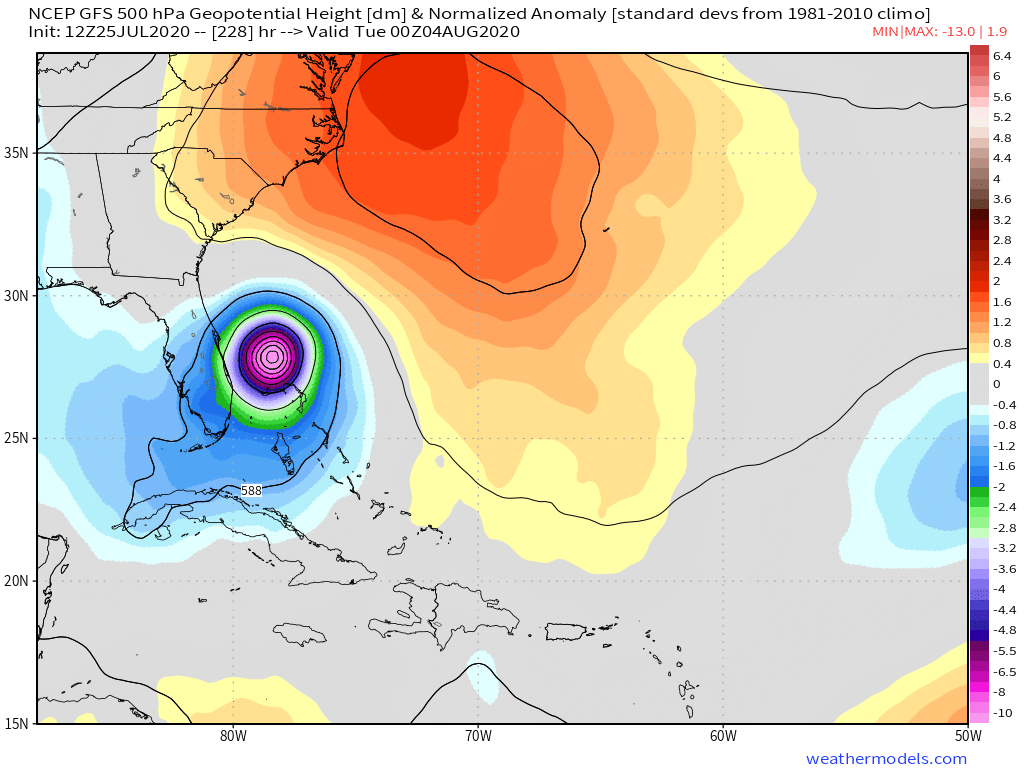
This should not be surprising since the NAO is forecast to shoot upwards and get positive near the first couple of days in August which would suggest more ridging. Lets watch the NAO and see how it changes

Sent from my iPhone using Tapatalk
Sent from my iPhone using Tapatalk
Last edited by WeatherEmperor on Sat Jul 25, 2020 11:38 am, edited 1 time in total.
4 likes

Re: ATL: INVEST 92L - Models
If these storms keep developing so strong early on like this there might not be another storm in the Gulf the rest of the season and the east coast could be getting hammered and probably a lot of recurves.
0 likes
-
toad strangler

- S2K Supporter
- Posts: 4546
- Joined: Sun Jul 28, 2013 3:09 pm
- Location: Earth
- Contact:
Re: ATL: INVEST 92L - Models
The GFS is fully on board. All this 12z GFS run does is tell everybody in the basin to be aware. Landfall point means absolutely nothing.
3 likes
My Weather Station
https://www.wunderground.com/dashboard/pws/KFLPORTS603
https://www.wunderground.com/dashboard/pws/KFLPORTS603
-
stormlover2013
Re: ATL: INVEST 92L - Models
Cpv17 wrote:If these storms keep developing so strong early on like this there might not be another storm in the Gulf the rest of the season and the east coast could be getting hammered and probably a lot of recurves.
Lol dude really?? Only reason it would go to East coast is trough breaks the ridge down come on dude
0 likes
-
Evan_Wilson
- Tropical Low

- Posts: 25
- Joined: Tue May 26, 2020 1:09 pm
Re: ATL: INVEST 92L - Models
Agreed, landfall points mean very little at this point in time until the system actually develops. As of now, we know there’s a tropical wave likely to develop and it has the potential to impact the U.S.
0 likes

-
HurricaneFrances04
- Category 2

- Posts: 597
- Joined: Mon Jun 25, 2012 8:09 am
- Location: Fort Lauderdale, Florida
Re: ATL: INVEST 92L - Models
CMC may be the eastern outlier and splits the gap between North Carolina and Bermuda
0 likes
-
northjaxpro

- S2K Supporter
- Posts: 8900
- Joined: Mon Sep 27, 2010 11:21 am
- Location: Jacksonville, FL
Re: ATL: INVEST 92L - Models
But, if the teleconnections forecast bears out next week, that +NAO will potentially be big trouble for Florida , the Southeast U.S. Coast, and even the Gulf Coast with a few of the opetational ensembles.
Last edited by northjaxpro on Sat Jul 25, 2020 11:54 am, edited 1 time in total.
0 likes
NEVER, EVER SAY NEVER in the tropics and weather in general, and most importantly, with life itself!!
________________________________________________________________________________________
Fay 2008 Beryl 2012 Debby 2012 Colin 2016 Hermine 2016 Julia 2016 Matthew 2016 Irma 2017 Dorian 2019
________________________________________________________________________________________
Fay 2008 Beryl 2012 Debby 2012 Colin 2016 Hermine 2016 Julia 2016 Matthew 2016 Irma 2017 Dorian 2019
-
SouthFLTropics

- Category 5
- Posts: 4258
- Age: 50
- Joined: Thu Aug 14, 2003 8:04 am
- Location: Port St. Lucie, Florida
Re: ATL: INVEST 92L - Models
12z GFS with the incredibly rare hit on Jacksonville. We’ve been down this road time and time again. Timing of troughs and ridges means everything. Predicting a landfall point over 10 days out is like throwing darts blindfolded. More often than not it ends up being a recurve away from the US. Given it will be early August and a +NAO, my confidence in a recurve is less than normal.
Sent from my iPhone using Tapatalk
Sent from my iPhone using Tapatalk
5 likes
Fourth Generation Florida Native
Personal Storm History: David 79, Andrew 92, Erin 95, Floyd 99, Irene 99, Frances 04, Jeanne 04, Wilma 05, Matthew 16, Irma 17, Ian 22, Nicole 22, Milton 24
Personal Storm History: David 79, Andrew 92, Erin 95, Floyd 99, Irene 99, Frances 04, Jeanne 04, Wilma 05, Matthew 16, Irma 17, Ian 22, Nicole 22, Milton 24
-
toad strangler
- S2K Supporter
- Posts: 4546
- Joined: Sun Jul 28, 2013 3:09 pm
- Location: Earth
- Contact:
Re: ATL: INVEST 92L - Models
HurricaneFrances04 wrote:CMC may be the eastern outlier and splits the gap between North Carolina and Bermuda
yep, CMC a classic re-curver. Certainly within the realm of possibilities. So far out. We track.
1 likes
My Weather Station
https://www.wunderground.com/dashboard/pws/KFLPORTS603
https://www.wunderground.com/dashboard/pws/KFLPORTS603
-
OuterBanker
- S2K Supporter
- Posts: 1761
- Joined: Wed Feb 26, 2003 10:53 am
- Location: Nags Head, NC
- Contact:
Re: ATL: INVEST 92L - Models
Interesting scenario with the GFS 12z run with a Fl/Ga border hit. Extremely rare, do not see that happening. At least the GFS is now seeing the future Isaias. Was wondering if it ever was going to catch it.
Euro has been consistent the last few runs with a weaker Caribbean cruiser into the Gulf.
CMC latest run is OTS off east coast.
Long time to watch, blindfold and dart board accuracy at this point.
Cannot come this way because I leave for Pittsburgh on the 7th for a week.
Euro has been consistent the last few runs with a weaker Caribbean cruiser into the Gulf.
CMC latest run is OTS off east coast.
Long time to watch, blindfold and dart board accuracy at this point.
Cannot come this way because I leave for Pittsburgh on the 7th for a week.
0 likes
Re: ATL: INVEST 92L - Models
12z Icon comes in and keeps it as a TD/low end TS going over the Northern Leewards, but missing PR and seems to be going OTS as well
0 likes
-
SouthFLTropics
- Category 5
- Posts: 4258
- Age: 50
- Joined: Thu Aug 14, 2003 8:04 am
- Location: Port St. Lucie, Florida
Re: ATL: INVEST 92L - Models
There’s only one thing we can say for certain at this point. A lot of us are going to lose sleep over the next week watching model runs come in.
Sent from my iPhone using Tapatalk
Sent from my iPhone using Tapatalk
2 likes
Fourth Generation Florida Native
Personal Storm History: David 79, Andrew 92, Erin 95, Floyd 99, Irene 99, Frances 04, Jeanne 04, Wilma 05, Matthew 16, Irma 17, Ian 22, Nicole 22, Milton 24
Personal Storm History: David 79, Andrew 92, Erin 95, Floyd 99, Irene 99, Frances 04, Jeanne 04, Wilma 05, Matthew 16, Irma 17, Ian 22, Nicole 22, Milton 24
-
toad strangler
- S2K Supporter
- Posts: 4546
- Joined: Sun Jul 28, 2013 3:09 pm
- Location: Earth
- Contact:
Re: ATL: INVEST 92L - Models
SouthFLTropics wrote:12z GFS with the incredibly rare hit on Jacksonville. We’ve been down this road time and time again. Timing of troughs and ridges means everything. Predicting a landfall point over 10 days out is like throwing darts blindfolded. More often than not it ends up being a recurve away from the US. Given it will be early August and a +NAO, my confidence in a recurve is less than normal.
Sent from my iPhone using Tapatalk
Excellent well thought out and level post.
0 likes
My Weather Station
https://www.wunderground.com/dashboard/pws/KFLPORTS603
https://www.wunderground.com/dashboard/pws/KFLPORTS603
Re: ATL: INVEST 92L - Models
stormlover2013 wrote:Cpv17 wrote:If these storms keep developing so strong early on like this there might not be another storm in the Gulf the rest of the season and the east coast could be getting hammered and probably a lot of recurves.
Lol dude really?? Only reason it would go to East coast is trough breaks the ridge down come on dude
All I’m saying is that the earlier and stronger these storms develop, the less likely they are to reach the Gulf unless the ridging is very strong.
0 likes
-
Evan_Wilson
- Tropical Low
- Posts: 25
- Joined: Tue May 26, 2020 1:09 pm
Re: ATL: INVEST 92L - Models
Basically anyone from the Gulf Coast to New England needs to pay attention to this storm. It’s 2020 and truly nothing is out of question.
0 likes
-
AutoPenalti
- Category 5
- Posts: 4091
- Age: 29
- Joined: Mon Aug 17, 2015 4:16 pm
- Location: Ft. Lauderdale, Florida
Re: ATL: INVEST 92L - Models
Cpv17 wrote:stormlover2013 wrote:Cpv17 wrote:If these storms keep developing so strong early on like this there might not be another storm in the Gulf the rest of the season and the east coast could be getting hammered and probably a lot of recurves.
Lol dude really?? Only reason it would go to East coast is trough breaks the ridge down come on dude
All I’m saying is that the earlier and stronger these storms develop, the less likely they are to reach the Gulf unless the ridging is very strong.
Irma would like a word with you.
3 likes
The posts in this forum are NOT official forecasts and should not be used as such. They are just the opinion of the poster and may or may not be backed by sound meteorological data. They are NOT endorsed by any professional institution or STORM2K. For official information, please refer to products from the NHC and NWS.
Model Runs Cheat Sheet:
GFS (5:30 AM/PM, 11:30 AM/PM)
HWRF, GFDL, UKMET, NAVGEM (6:30-8:00 AM/PM, 12:30-2:00 AM/PM)
ECMWF (1:45 AM/PM)
TCVN is a weighted averaged

Re: ATL: INVEST 92L - Models
OuterBanker wrote:Interesting scenario with the GFS 12z run with a Fl/Ga border hit. Extremely rare, do not see that happening. At least the GFS is now seeing the future Isaias. Was wondering if it ever was going to catch it.
Euro has been consistent the last few runs with a weaker Caribbean cruiser into the Gulf.
CMC latest run is OTS off east coast.
Long time to watch, blindfold and dart board accuracy at this point.
Cannot come this way because I leave for Pittsburgh on the 7th for a week.
Its 2020 anything is possible
0 likes
Who is online
Users browsing this forum: No registered users and 12 guests