EPAC: DOUGLAS - Remnants
Moderator: S2k Moderators
-
Kingarabian

- S2K Supporter

- Posts: 16360
- Joined: Sat Aug 08, 2009 3:06 am
- Location: Honolulu, Hawaii
Re: EPAC: DOUGLAS - Hurricane
Yeah it's looking lopsided. SHIPS has nearly 20kts of shear over it.
0 likes
RIP Kobe Bryant
-
Kingarabian
- S2K Supporter
- Posts: 16360
- Joined: Sat Aug 08, 2009 3:06 am
- Location: Honolulu, Hawaii
-
Aric Dunn
- Category 5

- Posts: 21238
- Age: 43
- Joined: Sun Sep 19, 2004 9:58 pm
- Location: Ready for the Chase.
- Contact:
Re: EPAC: DOUGLAS - Hurricane
Not sure anyone has mentioned this. but you really have to watch out for turbulent flow off of the islands they create vorticies/localized areas of low pressure that the models cannot forecast.
These vorts typically form on the opposite side of the island to the tropical system which has a tendency to pull the TC in a smaller scale Fujiwhara effect.
So as it passes the big islands there might be a bit of a bounce off due to the upslope wind flow and slightly higher pressure ..
but once the wind Direction changes vortices will start to be produced and I bet this get bent Westerly and goes right over some of the central and western Islands.
So Oahu might be in much more trouble. Even Maui
5 likes
Note: If I make a post that is brief. Please refer back to previous posts for the analysis or reasoning. I do not re-write/qoute what my initial post said each time.
If there is nothing before... then just ask
Space & Atmospheric Physicist, Embry-Riddle Aeronautical University,
I believe the sky is falling...
If there is nothing before... then just ask
Space & Atmospheric Physicist, Embry-Riddle Aeronautical University,
I believe the sky is falling...
-
JtSmarts

- S2K Supporter
- Posts: 1442
- Age: 40
- Joined: Thu Jul 10, 2003 1:29 pm
- Location: Columbia, South Carolina
Re: EPAC: DOUGLAS - Hurricane
Douglas seems to be holding steady thus far.
Hurricane Hunters from the Air Force 53rd Weather Reconnaissance
Squadron spent most of the night with Douglas, making 5 passes
through the center. The final pass contained some of the strongest
winds of the entire mission, with flight-level winds near 100 kt,
SFMR winds up to 79 kt, and a relatively steady pressure reading
near 983 mb. The initial intensity was maintained at 80 kt based on
these valuable data points. Also of extreme value is the fact that
the low-level center is south of the apparent center seen in
conventional satellite imagery, and closer to the islands than
might be otherwise expected. Although island-based radars are also
detecting Douglas' circulation, they are sampling the upper
portions of the cyclone that are sheared northward due to southerly
vertical wind shear.
Despite the vertical wind shear, Douglas has been slow to weaken,
and this trend will continue today as Douglas passes near, or
potentially over, the islands. Steadily increasing SSTs along the
forecast track are expected to limit the rate of weakening, while
the noted vertical wind shear may be confined to the upper-levels.
While Douglas is on the western edge of a ridge aloft, leading to
high-level southerly shear, a mid-level ridge is expected to build
westward to the north of Douglas through Monday, likely allowing
the low- to mid-level core of the cyclone to remain intact. The
updated intensity forecast once again closely follows the consensus
IVCN, and maintains Douglas as a hurricane until it passes west of
the islands. Steady weakening will occur thereafter due to
persistent southwesterly shear.
The mid-level ridge will continue to drive Douglas toward the west-
northwest, with the current motion vector estimated to be 285/14
kt. The forecast track takes the center of Douglas dangerously close
to the islands from Maui to Kauai through tonight, where a Hurricane
Warning is in effect. The updated forecast track is very close to
the previous forecast and the high-performing ECMWF guidance, and
anticipates some acceleration toward the west in the later periods
as the increasingly shallow system gets steered by the low-level
trade wind flow.
1 likes
-
Kingarabian
- S2K Supporter
- Posts: 16360
- Joined: Sat Aug 08, 2009 3:06 am
- Location: Honolulu, Hawaii
Re: EPAC: DOUGLAS - Hurricane
Maui has a hurricane warning, as we discussed today.

This might've been why the ensembles kept bringing this over Hawaii...
This might've been why the ensembles kept bringing this over Hawaii...
0 likes
RIP Kobe Bryant
-
supercane4867
- Category 5
- Posts: 4966
- Joined: Wed Nov 14, 2012 10:43 am
Re: EPAC: DOUGLAS - Hurricane
The edge of CDO is quickly approaching Maui. This is the end game folks. Let's hope residents took the hurricane warning seriously.

6 likes
-
Kingarabian
- S2K Supporter
- Posts: 16360
- Joined: Sat Aug 08, 2009 3:06 am
- Location: Honolulu, Hawaii
Re: EPAC: DOUGLAS - Hurricane
Aric Dunn wrote:Not sure anyone has mentioned this. but you really have to watch out for turbulent flow off of the islands they create vorticies/localized areas of low pressure that the models cannot forecast.
These vorts typically form on the opposite side of the island to the tropical system which has a tendency to pull the TC in a smaller scale Fujiwhara effect.
So as it passes the big islands there might be a bit of a bounce off due to the upslope wind flow and slightly higher pressure ..
but once the wind Direction changes vortices will start to be produced and I bet this get bent Westerly and goes right over some of the central and western Islands.
So Oahu might be in much more trouble. Even Maui
Thanks for the post, Aric. Yeah I figure the islands do weird stuff with these type of storms. My hunch is that this eventually makes landfall somewhere. It's what the ensembles have been insisting.
2 likes
RIP Kobe Bryant
-
SconnieCane
- Category 5
- Posts: 1013
- Joined: Thu Aug 02, 2018 5:29 pm
- Location: Madison, WI
Re: EPAC: DOUGLAS - Hurricane
Looks like a left (westward) bend in the last few frames. Probably a wobble, but wobbles are critical at this point in determining impacts to the islands.
0 likes
-
supercane4867
- Category 5
- Posts: 4966
- Joined: Wed Nov 14, 2012 10:43 am
Re: EPAC: DOUGLAS - Hurricane
Oahu can still count on the topographical effect of Maui to weaken the hurricane dramatically, but either way one of these islands will be screwed...
2 likes
-
Aric Dunn
- Category 5
- Posts: 21238
- Age: 43
- Joined: Sun Sep 19, 2004 9:58 pm
- Location: Ready for the Chase.
- Contact:
Re: EPAC: DOUGLAS - Hurricane
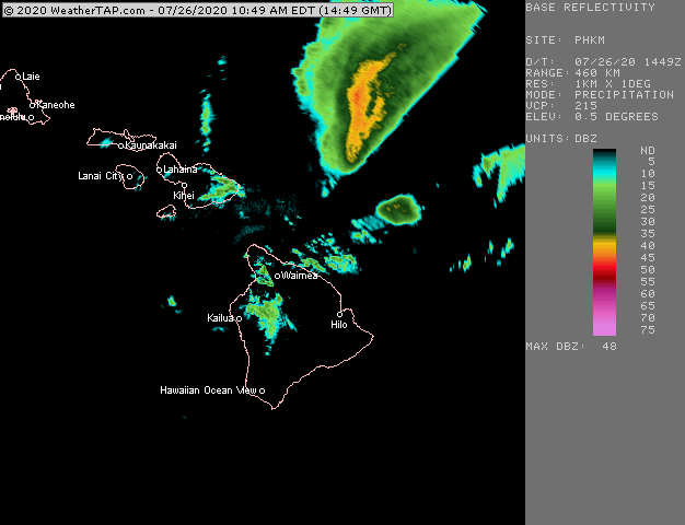
would be nice if there was not a giant chunk of the radar beam missing lol
3 likes
Note: If I make a post that is brief. Please refer back to previous posts for the analysis or reasoning. I do not re-write/qoute what my initial post said each time.
If there is nothing before... then just ask
Space & Atmospheric Physicist, Embry-Riddle Aeronautical University,
I believe the sky is falling...
If there is nothing before... then just ask
Space & Atmospheric Physicist, Embry-Riddle Aeronautical University,
I believe the sky is falling...
-
Aric Dunn
- Category 5
- Posts: 21238
- Age: 43
- Joined: Sun Sep 19, 2004 9:58 pm
- Location: Ready for the Chase.
- Contact:
Re: EPAC: DOUGLAS - Hurricane
supercane4867 wrote:Oahu can still count on the topographical effect of Maui to weaken the hurricane dramatically, but either way one of these islands will be screwed...
I personally think that as it approaches Maui the northerly winds on the high terrain will create a little bubble of high pressure ( localized of course) that will keep the eyewall from coming ashore on that island but will force it straight into Oahu..
0 likes
Note: If I make a post that is brief. Please refer back to previous posts for the analysis or reasoning. I do not re-write/qoute what my initial post said each time.
If there is nothing before... then just ask
Space & Atmospheric Physicist, Embry-Riddle Aeronautical University,
I believe the sky is falling...
If there is nothing before... then just ask
Space & Atmospheric Physicist, Embry-Riddle Aeronautical University,
I believe the sky is falling...
-
SconnieCane
- Category 5
- Posts: 1013
- Joined: Thu Aug 02, 2018 5:29 pm
- Location: Madison, WI
Re: EPAC: DOUGLAS - Hurricane
Anyone have any links to live cams/local coverage as conditions deteriorate?
Crazy to think this could be the second U.S. hurricane landfall in as many days. Has that ever happened before (let alone in two separate basins)? And it's still July.
Crazy to think this could be the second U.S. hurricane landfall in as many days. Has that ever happened before (let alone in two separate basins)? And it's still July.
0 likes

Re: EPAC: DOUGLAS - Hurricane
Aric Dunn wrote:Not sure anyone has mentioned this. but you really have to watch out for turbulent flow off of the islands they create vorticies/localized areas of low pressure that the models cannot forecast.
These vorts typically form on the opposite side of the island to the tropical system which has a tendency to pull the TC in a smaller scale Fujiwhara effect.
So as it passes the big islands there might be a bit of a bounce off due to the upslope wind flow and slightly higher pressure ..
but once the wind Direction changes vortices will start to be produced and I bet this get bent Westerly and goes right over some of the central and western Islands.
So Oahu might be in much more trouble. Even Maui
Is this why we see storms in the Caribbean "bounce" around coastlines at times?
2 likes
Andrew (1992), Irene (1999), Frances (2004), Katrina (2005), Wilma (2005), Fay (2008), Irma (2017), Eta (2020), Ian (2022)
-
Kingarabian
- S2K Supporter
- Posts: 16360
- Joined: Sat Aug 08, 2009 3:06 am
- Location: Honolulu, Hawaii
Re: EPAC: DOUGLAS - Hurricane
Aric Dunn wrote:supercane4867 wrote:Oahu can still count on the topographical effect of Maui to weaken the hurricane dramatically, but either way one of these islands will be screwed...
I personally think that as it approaches Maui the northerly winds on the high terrain will create a little bubble of high pressure ( localized of course) that will keep the eyewall from coming ashore on that island but will force it straight into Oahu..
Yeah recon basically had this at a heading that was more westerly vs a classic stair stepping motion that wouldve allowed it to gain more longitude.

Last edited by Kingarabian on Sun Jul 26, 2020 10:33 am, edited 1 time in total.
0 likes
RIP Kobe Bryant
-
supercane4867
- Category 5
- Posts: 4966
- Joined: Wed Nov 14, 2012 10:43 am

-
Kingarabian
- S2K Supporter
- Posts: 16360
- Joined: Sat Aug 08, 2009 3:06 am
- Location: Honolulu, Hawaii
Re: EPAC: DOUGLAS - Hurricane
supercane4867 wrote:IR loop looks like it's on a collision course with Maui.
https://i.imgur.com/IeEOVQh.gif
It's looking as if, if it's not Maui county then it will be Oahu.
0 likes
RIP Kobe Bryant
-
supercane4867
- Category 5
- Posts: 4966
- Joined: Wed Nov 14, 2012 10:43 am
-
Kingarabian
- S2K Supporter
- Posts: 16360
- Joined: Sat Aug 08, 2009 3:06 am
- Location: Honolulu, Hawaii
Re: EPAC: DOUGLAS - Hurricane
It would be an epic failure for the GFS if this thing hits Maui or Oahu.
1 likes
RIP Kobe Bryant
-
SconnieCane
- Category 5
- Posts: 1013
- Joined: Thu Aug 02, 2018 5:29 pm
- Location: Madison, WI
Re: EPAC: DOUGLAS - Hurricane
Kingarabian wrote:It would be an epic failure for the GFS if this thing hits Maui or Oahu.
GFS' poleward bias for NATL storms has been noted. I would imagine it's no different elsewhere in the world.
3 likes
-
supercane4867
- Category 5
- Posts: 4966
- Joined: Wed Nov 14, 2012 10:43 am

Who is online
Users browsing this forum: No registered users and 50 guests